
Abstract
In the United States, geographic information system (GIS) has been widely used and researched in thousands of organizations, including academic institutions, government agencies, and businesses. Few efforts have evaluated how much impact an organization has on the research community. To fill this gap, I established collaboration and citation networks among 2394 US organizations and calculated their impact scores based on quantity, diversity, and spread of scholarly activities. I reported top-ranking organizations between 1992 and 2011 and identified spatio-temporal patterns of GIS growth over the United States. The results are valuable for organizations to assess their strengths and weakness and find a path to broaden the impact.
Introduction
Geographic information system (GIS) has been disseminated over the United States for decades and widely researched in thousands of organizations, including academic institutions, government agencies, businesses, etc. Its scientific theories and technologies have revolutionized many traditional disciplines such as geography and brought together scientists and practitioners from a variety of fields. To date, more than 150 GIS graduate programs have been offered on campus or online (GradSchools Citation2013). GIS job opportunities are expected to grow 22% through 2020 according to the US Bureau of Labor Statistics (BLS Citation2012). The fast growth of GIS in education, scientific research, and industry requires an evaluation on the prestige and impact of GIS research organizations, a knowledge that could guide prospective students to choose universities, help researchers to find collaborators, and assist GIS practitioners to plan career paths.
Surprisingly, few efforts so far have been devoted to evaluating academic impact of GIS research organizations in the United States. An organization impacts a research community by exporting its scientific findings and innovative technologies to other members, through which it gains academic recognition and reputation. In the current literature, much attention has been paid to assessing academic institutions for various disciplines, such as geography, geology, and public health (Groop and Schaetzl Citation1997; Liu and Zhan Citation2012; Solem, Lee, and Schlemper Citation2009; Turner II and Meyer Citation1985). The US National Research Council (NRC) also issues departmental rankings every 5 years (NRC Citation2010). Few of them, however, have been oriented to GIS given its interdisciplinary nature. Furthermore, few of these studies have considered government agencies and businesses as GIS research organizations, although they have played important roles in the research community. Recently, there has been a number of studies assessing impact of GIS journals (Quiring Citation2007; Rohli and Liu Citation2008) or GIS researchers (Fisher Citation2006; Sun and Manson Citation2011), but few have analyzed organizations as basic units.
To fill this knowledge gap, I attempted to evaluate the academic impact of GIS research organizations in the United States. Here, the GIS research covers a wide range of topics that embrace GIS theories, methodologies, and applications (Bolstad Citation2012; Longley Citation2005). A GIS research organization is defined as any academic institution, government agency, business, and others whose publications have a “GIS” topic and have been indexed in the Web of Knowledge™ databases. This definition includes organizations that not only research on GIS, such as geospatial technologies and GIScience, but also apply GIS in other fields, for instance, public health, hydrology, and ecology. The academic impact measures the capability of an organization to share and export its scientific innovations through collaborations with others and citations by others. A network analysis approach was employed to measure their impacts over space and time.
The remainder of this article is organized into following sections. The second section introduces the construction of collaboration and citation networks among GIS research organizations in the United States. The third section describes the network analysis methods to evaluate impact of organizations. The section that follows presents and discusses results, and the last section draws conclusions from this research.
Data collection and network generation
To establish networks among organizations, I used a popular bibliographic database, ISI Web of Knowledge™, taking advantage of its wide coverage of quality journals and articles (ISI Citation2012). I set up search criteria as any article (1) with a topic of “GIS”, (2) having at least one affiliation in the United States, (3) being written in English, and (4) published between 1992 and 2011. In the search results, 98 article entries in the categories of cell biology, astronomy, and biochemistry were removed because their GIS acronyms bear a meaning other than “geographic information system”. The data query and cleaning finally returned 6667 GIS-related articles with detailed bibliographic information. A library was then created to store each article’s information, including its title, year of publication, journal name, author names, affiliations, volume-issue numbers, disciplinary categories, and reference list. Further, a computer algorithm was designed (and implemented by Visual C++) to scan and merge same affiliations with different names, for example, “SUNY BUFFALO” and “UNIV BUFFALO”. Notice that organizations with same names but at different locations were treated as two entities, for instance, “US EPA” in Las Vegas and Washington, DC. The scan had identified a total of 2374 unique organizations in the United States, including 746 academic institutions, 800 government agencies, 553 businesses, and 275 other organizations (e.g., independent authors and non-profit organizations). Based on street addresses of these organizations, I had identified their geographic locations on the Google Earth™ (Google Citation2012), recorded as latitudes and longitudes. These geographic locations were added into the library and used for network mapping purpose.
Network analysis approach has been intensively used to visualize and study academic networks (Assimakopoulos Citation2000; Marion et al. Citation2003; Small Citation1999). A network is composed of nodes and links, where nodes represent entities and links abstract relationships between entities. To measure the academic impact of GIS research organizations, a collaboration network and a citation network among them were established, respectively, both depicting how organizations share and export their innovations. For the collaboration network, each organization was represented as a network node. If two different organizations had published together in a same article, an undirected link was placed between their corresponding nodes. For example, David Mark from the SUNY Buffalo had coauthored with André Skupin from the University of New Orleans in an article titled “Features, Objects, and other Things: Ontological Distinctions in the Geographic Domain” in 2001. An undirected link was placed between the SUNY Buffalo and the University of New Orleans. Self-collaborations within an organization, e.g., those between departments within a university, are not considered in the network building. A weight was assigned to a link to indicate the number of articles published together by a pair of organizations. By iterating all GIS articles, an undirected collaboration network was created with 2374 nodes and 5449 links ().
Figure 1. Spatial networks between GIS research organizations in the United States: (a) Collaboration network and (b) citation network accumulated from 1992 to 2011. Only links with weights greater than 2 are displayed for graph clarity.
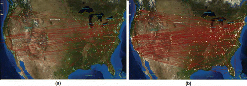
Similar to the collaboration network, the citation network modeled organizations as nodes, but links between nodes represent citations. That is, if an article published by Organization A cited another article from Organization B, a directed link was then placed on A and pointed to B, i.e., A cited B. For instance, if the article “Features, Objects, and other Things: Ontological Distinctions in the Geographic Domain” authored by David Mark from SUNY Buffalo in 2001 had been cited by Reginald G. Golledge from UC Santa Barbara (UCSB) in 2007 in the article “Matching Geospatial Concepts with Geographic Educational Needs”, a directed link was placed on UCSB and pointed to SUNY Buffalo. A weight was assigned to a link to indicate the number of citations made from a referring organization to a referred organization. To generate such a network, the reference list of each article was the major information to identify citations. Since reference entries had no affiliation information, a computer program was designed to match an article to each reference entry in the library. An article match was deemed to be successful only when a reference’s first author name, journal name, year of publication, and volume and issue numbers all matched to those of one article in the library. From the matched article, the organization(s) being cited could be identified, and directed links were placed from referring organization(s) to referred organization(s). Self-citations within an organization are not considered for the subsequent analysis. By checking reference lists of every article, a directed network was created with 2374 nodes and 10,816 links ().
Methodology
Impact score
In the collaboration network, the impact of an organization was evaluated as a composite score that incorporates the quantity, diversity, and spread of its collaborations. Specifically, the quantity of collaborations was measured by the total number of collaborations this organization had involved in. In the network analysis, the quantity is the sum of all weights on the links that are attached to a node, i.e., the weighted degree of the node. The diversity of collaborations is the total number of distinct organizations that had collaborated with this organization. Different from the quantity, the diversity is the total number of links associated with a node, i.e., the unweighted degree of the node. No matter how many collaborations between two organizations, the diversity only counts them as one. The spread of collaborations was defined as the total spatial distances from this organization to all of its collaborators, indicating its geographic impact in the nationwide community. An organization would have a broader impact in the community if its collaborators were widely distributed, and vice versa. Since each node in the network has a pair of latitude and longitude, the spatial distance between any pair of nodes were computed as the great circle distance. Given that the quantity, diversity, and spread are in different units, each was standardized, by Equation 1, to a non-dimensional scale between 0 and 100.
Similarly, the impact of an organization in the citation network was evaluated based on the quantity, diversity, and spread of citations referred to this organization. The quantity is the weighted in-degree of a node in the network, indicating the number of times an organization being cited by others. The diversity is the unweighted in-degree of a node, measuring the number of distinct organizations that had cited this organization. The spread is the total spatial distances between this organization and all organizations that cited it, reflecting the geographic influence of this organization. These three measurements were standardized using Equation (1) and then averaged to assess the impact score of an organization in the citation network, hereinafter referred to as the citation score.
Since an organization often impacts the community through both collaborations and citations, an overall impact score was also calculated by further averaging its collaboration and citation scores. Based on their collaboration, citation, and overall impact scores, I ranked the academic institutions, government agencies, and businesses, respectively.
Spatio-temporal variations
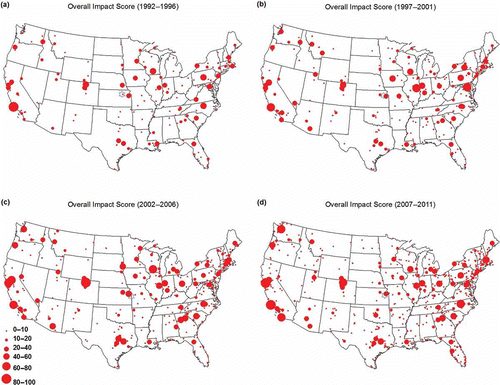
In order to reveal temporal variation of organizations’ impact, I have divided the 20 years’ time span into four periods, with a length of 5 years for each. The overall impact scores for organizations were estimated for each period following the same approach described above. The only difference is that the x variable (Equation 1) represents a measurement for a 5-year period, not the entire 20 years. The min(x) and max(x) are also the 5 years’ minimum and maximum, respectively. The overall impact of an organization was then mapped as a circle at its geographic location, with a symbol size proportional to its impact score. A serial of maps were then created to display the rise and fall of US organizations in the GIS research community over 20 years (). Further, I calculated the geographic center of academic impact in the United States for each period, in order to show how it has been changed over time and space. The latitude and longitude of geographic center was weighted by the impact scores of organizations, as shown in Equation (2):
Figure 2. Spatio-temporal dynamics of impact scores for US organizations from 1992 to 2001. Each circle represents an organization, and the size is proportional its impact score. The blue hexagon symbol on each panel indicates the geographic center of impact scores.
Results and discussion
The impact analysis described above was applied to each of the 2374 US organizations, and the resultant scores were ranked from high to low. Due to the word limit, I focused my discussion on the Top 10 academic institutions, government agencies, and businesses in terms of their collaboration scores and citation scores. In addition, I also presented the Top 20 organizations with the highest overall impact scores in each of the three categories.
Organization ranking in collaboration network
In the collaboration network, the University of California at Berkeley heads the collaboration score among the 745 academic institutions (). It is the only one organization with all the three contributing measures above 90, implying a balanced development. The network analysis shows that UC Berkeley has 192 collaboration counts with 95 different originations in the last two decades, consistent with its prestige in geography, environmental science, and public health. Particularly, its collaborations are the most extensive across the United States (spread score = 100) with a total collaboration distance of 189,010 km. University of Wisconsin – Madison (Ranked No. 5) has the highest score in diversity, researching with 102 distinct organizations. Its major weakness comes from the low spread score of 64, indicating a localized collaborative pattern. University of South Carolina (No. 9) possesses the largest quantity of collaborations (195), but its diversity only scores 66, suggesting its small pool of collaborators as a weak point.
Table 1. Top 10 academic institutions, government agencies, and businesses based on the collaboration score [quantity, diversity, and spread] from 1992 to 2011.
Regarding to the government agencies, their collaboration scores are much lower than the Top 10 academic institutions, possibly due to their own specializations. The NASA Godard Space Flight Center has topped any other government agency due to its dominant lead in the three contributing measures. It is claimed to be the nation’s largest organization of combined scientists, engineers, and technologists that study the Earth, the Sun, solar system, and the universe (NASA Citation2012). Two health-related agencies take the second and third places, possibly because of a large amount of grant opportunities and contracts in health sciences. The US Environment Protection Agency (EPA) at Las Vegas achieves No. 4, benefiting from the National Environmental Research Laboratory there. The Earth Resources Observation and Science (EROS) Center under US Geological Survey (USGS) is ranked to No. 5 due to its critical role in land use and land cover (LUCC) study, an intensively pursued topic in GIS and remote sensing.
All of the top-ranked businesses score under 20, far lower than those of academic and government organizations. This is not surprising because their primary goals are not oriented to scientific research and publications, but more concentrated on commercial profits. Given the dominance of ArcGIS software in the market, the Environmental System Research Institute (ESRI) becomes the leading business in the GIS research community. Three principal locations of the RAND Corporation are all in the Top 10 list. A majority of collaborations with the RAND were oriented to GIS and public health policies. An examination of its network shows that these three RAND units have worked with a wide variety of academic and governmental organizations, let alone the coast-to-coast collaborations among the three. Other Top 10 businesses are engaged in medical services (Westat), natural resource conservation (Weyerhaeuser and ABR), software (Microsoft), and power industry (EPRI).
Organization raking in citation network
The quantity of citations has been widely used to assess an organization’s reputation in research. I have additionally considered the diversity and spread of citations for a more comprehensive assessment. Compared to the collaboration network, the landscape of Top 10 academic institutions has a dramatic change (). Six new universities emerge in the list, while only four remain. This seems to contradict a recent finding by Figg et al. (Citation2006) that the collaboration and citations are highly correlated. A reasonable explanation is that this study measures the geographic impact of organizations, which has not been considered before. For academies, the University of California at Santa Barbara scores significantly higher than any other organization. Not only the most cited organization it is, but also its work has been cited by the most diverse organizations (186) and produced the broadest impact over the United States (485,240 km). The Colorado State University (No. 2) is excellent and prestigious in its atmospheric sciences, meteorology, and oceanography (No. 1 in the NRC ranking), where GIS is intensively employed. Not strong in the number of citations, the UC Berkeley drops to No. 4 in the citation network, but its publications have remained a diverse and wide impact.
Table 2. Top 10 academic institutions, government agencies, and businesses based on the citation scores [quantity, diversity, and spread] from 1992 to 2011.
The Top 10 government agencies in the citation network are similar to those in the collaboration network, but their order changes remarkably. NASA Goddard Space Flight Center falls down to No. 6 due to its localized citations (spread = 13). The USDA Grassland Soil and Water research laboratory takes the first place with high quantity and diversity of citations. Its work has been cited 360 times by 118 organizations in the last 20 years. The USGS EROS Data Center jumps to the third place in the citation network, as it provides data service to support enormous GIS and RS studies. The CDC and NIH persist in the Top 10 list due to a great number of researchers as their employers and a large pool of medical science publications.
The Top 10 businesses differ a lot between the collaboration and citation networks. The ESRI is the only business in both Top 10 lists ( and ), given its high reputation in the GIS industry. A majority of high ranking businesses (6 out of 10) have involved in soil and water studies, including the ZedX, Inc., Borton-Lawson, Tetra Tech Inc., Pacific Forest Trust, Mannik & Smith Group, and Cacheva International Corporation. There are also two health-oriented companies in the Top 10, namely, the Impact Assessment, Inc. (No. 1) and the EQE International, Inc. (No. 8), offering risk assessment service for local health departments. Their work has been highly cited because their collaborators are top medical schools, such as University of Minnesota and University of California Los Angles.
Overall academic impact of organizations
By considering their strengths in both collaboration and citation, I have rated the overall impact of organizations in GIS research (). Academic institutions from the eastern and western states have an even split in the Top 20 list, but those from the west dominate the upper 10 (7 out of 10) and push those from the east down to the lower 10. There are also some unexpected rankings. For example, the UC Davis is ranked high as No. 5, while the SUNY Buffalo (24th) and the University of Maine (40th) are out of Top 20. Only 9 academic institutions in are also listed in the NRC ranking list as Top 20 geography programs (NRC Citation2010). This is because GIS, as an interdisciplinary field, is not only a basic science focusing on spatial information theories, but also an applied science intersecting with various fields, such as geology, forestry, environmental sciences, and public health. The SUNY Buffalo and University of Maine are prestigious in their theoretical studies and that is why the National Centers for Geographic Information and Analysis (NCGIA) are located there. However, researchers on GIS theories are only a small group as compared to those who engage in GIS applications. This explains why these two organizations have low citation and collaboration scores (around 30s). On the contrary, the UC Davis has a wide range of strong programs in environmental sciences, engineering, and medical sciences, where GIS are intensively used. It is not surprising that it has high collaboration and citation scores. This inconsistency between this ranking and the normal expectancy highlights the uniqueness and necessity of this study that treats GIS as an interdisciplinary field.
Table 3. Top 20 academic institutions, government agencies, and businesses based on the overall impact scores considering both collaborations and citations from 1992 to 2011.
Turning to the government agencies, NASA, USDA, USGS, EPA, and DHHS (CDC and NIH) are the most influential entities in GIS research. The ranking implies that GIS applications in government have been concentrated on following topics: remote sensing, agriculture, geosciences, natural resources, environmental sciences, and human health. For businesses, the ESRI far outscores any other business in GIS industry, possibly due to the popularity of its GIS products. The services provided by the Top 20 businesses are primarily oriented to natural resource management, agriculture, environmental studies, and public health. These services overlap with the GIS in the government since many businesses are contractors of government.
Spatio-temporal dynamics of rankings
As shown in , the period of 1992–1996 can be coined as the “Era of UCSB”. UC Santa Barbara played a predominant role in GIS research with a remarkably high impact score of 97. The UNC Chapel Hill and Penn State University took the second and third places, but only scored 59 and 53, much lower than UCSB. Another characteristic of this period is the smallest number of organizations in the community, compared to other three periods. Only 335 organizations (15% of all organizations) had their work either published or cited.
The second period from 1997 to 2001 can be dubbed as the “Rise of the East” (). Although UCSB retained its first place (impact score = 69), its leading role was not as significant as in the first period. Academic institutions from the eastern states had grown fast and remarkably narrowed the gap, such as UIUC (scored 63), Penn State University (58), and UW-Madison (55). NASA Goddard Space Flight Center in Maryland beat AMES center in California, and became the No. 1 government agency. The rise of the east can be attributed to a large increase in the number of organizations (a total of 599) during this period, mostly in the eastern United States. More collaborations and citations, thus, occurred in the east, resulting in a faster growth than the west.
The third period (2002–2006) was characterized by the “Upsurge of CSU”. The Colorado State University had largely expanded its impact (Ranked No. 1) in the GIS community and became the largest node in . An examination of CSU history showed that it was during this period that a number of collaborative research centers had been established in atmospheric studies. This period had also seen a rapid growth of organizations in the Midwest and South, for example, UM-Wisconsin (No. 3), TAMU (No. 5), Purdue University (No. 7), USGS EROS Data Center (No. 1), and USDA Grassland Soil & Water Research Lab (No. 3).
The most recent period (2007–2011) witnessed a “Return of the West” (Figure 2d). UC Berkeley (No. 1) and UCSB (No. 2) had regained their dominance in the community, scoring 83 and 80, respectively. UNC Chapel Hill (No. 5) and UW Madison (No. 7) were the only two academic institutions in the Top 10, but only scored 63 and 58, respectively. More than 1100 organizations had their work either published or cited during this period, implying a wide diffusion of GIS over the United States.
Looking through the four periods, I have identified an “Ivy League” in the GIS research community, whose members have remained Top 10 rankings over 20 years. The Ivy League consists of four academic institutions: UCSB, UC Berkeley, Colorado State University, and UW-Madison, and two government agencies: NASA Goddard Space Flight Center and AMES center. These organizations have been acting as pivotal force in developing and disseminating GIS over the United States. In addition, the geographic center of impact scores had only varied a little in the last 20 years, slowly easting from 97°W to 95°W. The slight movement suggests a balanced development between the east and the west. Although there are fewer organizations in the west than the east, most of influential ones are located in the west, resulting in equilibrium on average.
Limitations and future work
A few limitations should be considered when interpreting the results. First, only one bibliographic database had been searched for GIS-related articles, leading to a limited sample size. Given the wide and quality coverage of articles in the Web of Science database, I believe that the results are a good representation to the landscape of GIS research community in the United States. Nevertheless, the future work is needed to include other bibliographic databases, such as the GEOBASE of Elsevier and the Google Scholar, and thus cover more articles as well as organizations. Second, the methodology assigned equal weights to the quantity, diversity, and spread when computing the impact scores. In the follow-up study, a sophisticated method, such as the Delphi approach, is needed to justify these weights. The choice of geographic distance sum as a spread measure is also debatable, and more appropriate index is worthy of exploration. Third, the networks generated were contained within the United States, while international organizations were not included in the analysis. One reason is that the language barriers make it difficult to interpret non-English bibliographies, and thus many international collaborators and citations are hard to identify and geo-reference. Fortunately, many scientometric studies have shown that the number of collaborations and citations often follow a distance decay law (Frenken et al. Citation2009; Hoekman, Frenken, and Van Oort Citation2009; Ponds, Van Oort, and Frenken Citation2007). A vast majority of GIS collaborations and citations happen between organizations that are not far away from one another (Mao Citation2013). As a result, cross-nation collaborations and citations are much fewer than those within the United States, and they may not significantly alter the ranking lists.
Conclusions
In this research, I evaluated the academic impact of US organizations in the GIS research community during 1992–2011, from a perspective of their collaborations and citations. With a network analysis approach, I have rated the Top 20 academic institutions, government agencies, and businesses, respectively. The spatio-temporal analysis shows that the eastern and western United States had a relatively balanced development in the GIS research, while the geographic center of impact moving slowly toward the east during the past 20 years. Although the western organizations are fewer in number, they are more influential than eastern organizations in the GIS research.
The contribution of this research to the literature has two folds. First, I have proposed a three-dimensional method to evaluate an organization’s academic impact based on quantity, diversity, and spread of their scholarly activities. Particularly, I added a spatial dimension into the evaluation and thus accounted for the geographic extent of an organization’s impact. In previous studies, social distance is a widely used measure, but it fails to discern if an organization has a statewide, nationwide, or worldwide reputation. The proposed spread measure is the first attempt to address this issue and reasonably reflects the geographic impact of many organizations. Still in its infancy, the spread measure is sensitive to the spatial distribution of organizations and may bias the evaluation of those in Alaska and Hawaii. For this reason, I have also provided the rankings only based on the quantity and diversity of collaborations and citations (see the Supplementary Document).
Second, I have filled the knowledge void that no ranking information is available for organizations engaged in GIS research. In addition to academic institutions, I expanded the evaluation to government agencies and businesses, making the ranking lists useful not only for students and scientists, but also for GIS practitioners in industry and government. The overall scores could be used as a reference by prospective students to choose their universities or by GIS practitioners to decide their job placement. Academic institutions could compare their quantity, diversity, and spread of scholarly activities with those of their peers, then identify their strengths and weakness in GIS research achievements, and find a path to broaden their impact.
Supplemental data
Supplemental data for this article can be accessed here: http://dx.doi.org/10.1080/15481603.2014.883211
Tables S1, S2 & S3_Top 10 academic institutions, government agencies, and businesses based on a 2-dimensional collaboration score
Download MS Word (31.4 KB)References
- Assimakopoulos, D. G. 2000. “Social Network Analysis as a Tool for Understanding the Diffusion of GIS Innovations: The Greek GIS Community.” Environment and Planning B 27 (4): 627–640.
- BLS. 2013. “Occupational Outlook Handbook.” U.S. Bureau of Labor Statistics 2012. Accessed January 13. http://www.bls.gov/ooh/architecture-and-engineering/cartographers-and-photogrammetrists.htm
- Bolstad, P. 2012. GIS Fundamentals. White Bear Lake, MN: Eider Press.
- Figg, W. D., L. Dunn, D. J. Liewehr, S. M. Steinberg, P. W. Thurman, J. C. Barrett, and J. Birkinshaw. 2006. “Scientific Collaboration Results in Higher Citation Rates of Published Articles.” Pharmacotherapy 26 (6): 759–767.
- Fisher, P. 2006. Classics from IJGIS: Twenty Years of the International Journal of Geographical Information Science and Systems. Boca Raton, FL: CRC.
- Frenken, K., J. Hoekman, S. Kok, R. Ponds, F. van Oort, and J. van Vliet. 2009. “Death of Distance in Science? A Gravity Approach to Research Collaboration.” In Innovation Networks: New Approaches in Modelling and Analyzing, edited by A. Pyka, and A. Scharnhorst, 43–57. Berlin: Springer.
- Google. 2012. “Google Earth.” Google 2012. Accessed September 15. http://www.google.com/earth/index.html
- GradSchools. 2013. “Geographic Information Systems Graduate Programs.” GradSchools.com 2013. Accessed January 18. http://www.gradschools.com/search-programs/geographic-information-systems
- Groop, R. E., and R. J. Schaetzl. 1997. “Productivity Profiles of PhD‐Granting Geography Departments in the Unites States: 1980–1994.” The Professional Geographer 49 (4): 451–464.
- Hoekman, J., K. Frenken, and F. Van Oort. 2009. “The Geography of Collaborative Knowledge Production in Europe.” The Annals of Regional Science 43: 721–738.
- ISI. 2013. “Web of Science.” Thomson Reuters 2012. Accessed January 13. http://thomsonreuters.com/products_services/science/science_products/a-z/web_of_science/
- Liu, X., and F. B. Zhan. 2012. “Productivity of Doctoral Graduate Placement among PhD-Granting Geography Programs in the United States: 1960–2010.” The Professional Geographer 64 (4): 475–490.
- Longley, P., ed. 2005. “Geographic Information Systems and Science.” New York: John Wiley & Sons.
- Mao, L. 2013. “The Geography, Structure, and Evolution of the GIS Research Community in the US: A Network Analysis from 1992 to 2011.” Transactions in GIS. doi:10.1111/tgis.12054.
- Marion, L. S., E. Garfield, L. L. Hargens, L. A. Lievrouw, H. D. White, and C. S. Wilson. 2003. “Social Network Analysis and Citation Network Analysis: Complementary Approaches to the Study of Scientific Communication. Sponsored by SIG MET.” Proceedings of the American Society for Information Science and Technology 40 (1): 486–487.
- NASA. 2013. “About the Goddard Space Flight Center 2012.” Accessed January 13. http://www.nasa.gov/centers/goddard/about/index.html
- NRC. 2013. “Doctoral Programs by the Numbers: Geography 2010.” Accessed January 13. http://chronicle.com/article/NRC-Rankings-Overview-/124734/
- Ponds, R., F. Van Oort, and K. Frenken. 2007. “The Geographical and Institutional Proximity of Research Collaboration.” Papers in Regional Science 86: 423–443.
- Quiring, S. M. 2007. “Trends in Publication Outlets of Geographer-Climatologists.” The Professional Geographer 59 (3): 357–364.
- Rohli, R. V., and K. Liu. 2008. “Citation of Research in Journals of Interest to Applied Geographers.” Applied Geography 28 (3): 151–167.
- Small, H. 1999. “Visualizing Science by Citation Mapping.” Journal of the American Society for Information Science 50 (9): 799–813.
- Solem, M., J. Lee, and B. Schlemper. 2009. “Departmental Climate and Student Experiences in Graduate Geography Programs.” Research in Higher Education 50 (3): 268–292.
- Sun, S., and S. M. Manson. 2011. “Social Network Analysis of the Academic GIScience Community.” The Professional Geographer 63 (1): 18–33.
- Turner II, B. L., and W. B. Meyer. 1985. “The Use of Citation Indices in Comparing Geography Programs: An Exploratory Study.” The Professional Geographer 37 (3): 271–278.