
Abstract
The article deals with the issue of the aerial survey of forest transportation (road mapping and calculation of skidding distance), via methods of remote sensing of the Earth and geographical information system (GIS) applications. Road network mapping was carried out by the manual vectorisation of linear objects based on terrain models created from laser scanning data. Based on the roads and digital terrain model derived from airborne laser scanning data, the average skidding distance for every forest stand was calculated. An algorithm created in the ArcGIS environment was used for calculation, which fully automated the calculation of the skidding distance. The versatility of the suggested method was verified on the study area of the University Forest Enterprise of the Technical University in Zvolen. The results indicated that it is possible to identify the permanent and, under certain conditions, temporary network of forest roads from airborne laser scanning data, including the case of roads situated under tree crowns. In the area of interest less than 13% of the roads could not be identified from the airborne laser scanning data. Likewise the algorithm for skidding distance calculation also performed well.
Introduction
The most commonly employed transportation system in forest management is the network, with road and cableway routes designed to gain access to forest stands. The level of access, to a great extent, determines forest transport logistics – the system of flow of raw materials, products and services. At the same time, it influences the concept of protection against fires and floods, as well as the public utilisation of the accessed landscape (Gumus, Acar, and Toksoy Citation2008). However, an unsuitable road network structure can have a devastating effect on this landscape, with the building and use of forest roads in some cases having more negative than positive effects (Saunders et al. Citation2002). These effects are connected mainly with the influence on the level of flood flows, or the speed of surface run-off into water courses and the subsequent increased risk of erosion mainly in small river basins (Bowling and Lettenmaier Citation1997; Scherer and Pike Citation2003). To provide for the optimal access of the landscape with no or minimal negative effects, it is necessary to have current and representative information about the latest state of the forest road network (Messingerová and Tajboš Citation2007).
One of the basic methods of obtaining such data is the terrain transportation survey (Klč, Bránka, and Žáček Citation2010), which enables the user to obtain accurate quantitative and qualitative forest road network characteristics. However, the method is both time consuming and financially consuming. Moreover, information about the position of the road in the forest environment, currently determined by GNSS technology, can be considerably influenced by vertical and horizontal accuracy. According to Klimánek and Mikita (Citation2009), this inaccuracy, largely associated with stand age and crop density, is typically in the range of 2–6 m root mean square error (RMSE).
For these reasons, a combination of terrain survey and aerial survey (based on the remote sensing of the Earth) is used more often nowadays. Today the technology of aerial photography is an established part of forest management (Phillips et al. Citation2012), and it has also proved useful in the field of transportation survey. However, the identification of roads at various levels of automation is still limited to road networks sufficiently visible in aerial images (Asnera et al. Citation2002). This is a serious problem; even the combination of contact and contactless data acquisition makes the original procedure only partially more effective. For example, White et al. (Citation2010) state that in the study area of dense forest canopy, only 15% of the target road was visible on aerial images with spatial resolution of 1 m.
Airborne laser scanning (ALS) brings a relatively new opportunity; it can be considered as a progressive alternative among technologies for the remote sensing of the Earth. This method works on the principle of emitting laser pulses towards a certain object and the detection of their reflection from the object. While emitting and receiving pulses, the position and orientation of the sensor, the scan angle, as well as the time of flight of the two-way travel distance of the laser pulse is detected. This process derives the three-dimensional coordinates of the points, representing the part of the object which reflected the pulse. Characteristics of ALS include high frequency of laser beam emitting, various sizes of laser beam footprint and the possibility to receive more reflections from one pulse. In this way, it is also possible to record overlapping objects (e.g. vegetation). This ability is very important for the purpose of a transportation survey, as it also enables recording terrain under forest cover. The accuracy of the terrain profile record depends on the number of recorded points. The number of points is mainly influenced by the height and speed of the flight, the scanning device used, geomorphology and the terrain surface. The density of points reaches a range of 1–40 points per square metre (in some cases more); practical experience suggests that for the purposes of a transportation survey it is desirable to achieve at least 1 point/m2. Digital terrain model (DTM) generated from the data with low density of points does not describe the terrain enough, especially under forest canopy there could be errors in DTM due to low point density on the terrain (Smreček and Danihelová Citation2013). Ideally the accuracy of the terrain model reaches ±15 cm for vertical accuracy and ±20 cm for horizontal accuracy (Ahokas, Kaartinen, and Hyppä Citation2003). According to the results of Hyyppä et al. (Citation2003) and Cibulka and Mikita (Citation2011), this error increases with the slope, and for the average conditions in a forest environment, it reaches the value of approximately ±22 cm (Sačkov and Kardoš Citation2013). Hodgson and Bresnahan (Citation2004) evaluated the variability of vertical accuracy for ALS data on six land cover categories. RMSE values ranged in their work from a low of ±17 to ±19 cm (asphalt, low grass) to a high of ±26 cm (deciduous forest). Another advantage of ALS data is that, besides the position of the points, it is possible to record e.g. the intensity of reflected pulse, number of pulse reflections, etc.
The main benefits of ALS technology for transport survey are therefore high-quality terrain models which are suitable reference data sources for the manual or automated mapping of forest roads. Nowadays the manual solution dominates in forestry practice; therefore this approach is presented in this article. Despite this, however, for the future, more efficient and more objective innovative (automated) approaches are sought. Based on the automation level and the number of used attributes recorded for each acquired point, several methods for the identification of linear elements (roads) exist. Essentially all procedures are based on the primary detection of a line, its tracking/monitoring and secondary vectorisation (White et al. Citation2010). They use methods of mathematical morphology, image segmentation, image classification and dynamic programming (Rieger et al. Citation1999; Auclair-Fortier et al. Citation2000; Deschenes, Yiou, and Auclair-Fortier Citation2004; Lee, Slatton, and Jhee Citation2005; David et al. Citation2009; García-Balboa, Reinoso-Gordo, and Ariza-López Citation2013).
Calculation of skidding distances is the final step in a forest transport survey. This distance is one of the general characteristics used to describe forest opening of the forest. In principle, forest opening is then an overall characteristic used to describe the location of forest roads in the landscape. In the past, the calculation was carried out mainly on the basis of theoretical calculations. Today, for this purpose, typically GIS analysis tools are used that work with, more accurately, value of the distance, slope, and so on (e.g. Storck et al. Citation1998; Tuček and Suchomel Citation2003; Ghaffariyan et al. Citation2010). In this article we present our own solution based on GIS applications.
The aim of this article is to present and to validate the universal solution of forest transport survey, consisting of forest road mapping based on ALS data and the automated evaluation of basic indicators of forest opening using GIS tools.
Material and methods
Study area
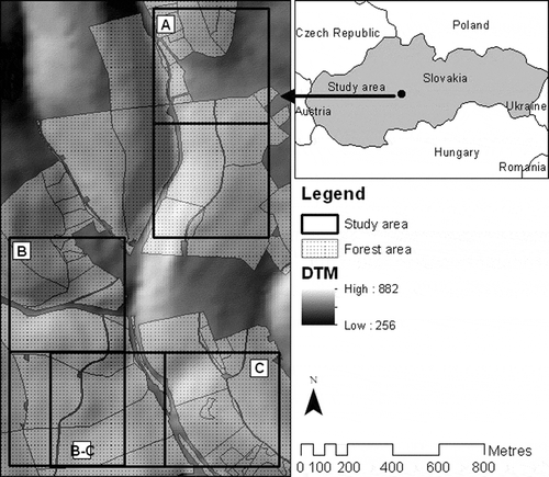
The study area consists of three reference areas with the size of 50 ha (A, B: 500 × 1000 m, C: 1000 × 500 m). All areas are part of the University Forest Enterprise of the Technical University in Zvolen (48˚ 37΄ N, 19˚ 04΄ E). The selection of areas was carried out with regard to recording various biological and geomorphologic conditions, and their position in Slovakia as illustrated in . The relevant part of area A is forest-free or with sparse forest. Areas B and C have a similar structure of forest with higher density, whereas they overlap partially for the purpose of additional checking of the edited road network (B-C).
Figure 1. Location of the study area in Slovakia.
ALS and ground data
Acquiring of ALS data was carried out in September 2011 for the whole study area using a RIEGL Q680i scanner. The scanner, at an average height of 700 m, field of view 60°, average overlap 40%, and frequency 120 Hz (SR), provided density of scanning of approximately 5 points (returns) per square metre.
Acquiring of ground data was carried out during 2011. The terrain survey was carried out on a large area and was aimed at recording temporary paved roads serving for wood transport and skidding. Their position, category according to the standard of national technical norm (STN 73 6108) and in particular parts also characteristics such as road material, road surface, break-up, slope stability and the state of road drainage were recorded. The position and category of roads were acquired especially by manual editing based on current aerial images and forest stands maps. Then a terrain survey was conducted, which enabled the checking and eventual correction of acquired data about the position and road category. At the same time, on a smaller portion of the roads increased qualitative characteristics were also being discovered. More about this methodology can be found in Smreček and Sedliak (Citation2011). As this survey was conducted for the whole area of the forest enterprise and detailed findings were carried out only in a particular part, it was necessary to provide for an additional terrain survey providing the necessary characteristics for the whole study area. Due to this fact, early in 2012 an additional terrain survey was conducted, providing a full spectrum of information about the qualitative and quantitative characteristics of the forest roads network in the study area. An overview of the basic characteristics of the forest road network located in study areas A, B and C is illustrated in .
Table 1. Quantitative and qualitative characteristics of the road network in the study area acquired via terrain survey (percentage of a particular characteristic in the overall length of the forest road network).
Forest roads mapping
Road network mapping was possible only after processing raw ALS data. This activity was carried out by relative and absolute data georeferencing, their classification into point classes (ground) and their final export into LAS 1.2 format. All these activities were done by a laser data supplier (Photomap, Ltd.) and via software from the company RIEGL Laser Measurement System, Ltd. and Terrasolid, Ltd.
Three alternative raster layers with a spatial resolution of 50 cm were created. This process was carried out by means of the GIS ArcGIS Desktop 10 (ESRI), as well as via the SAGA – LIS application (Laserdata, Ltd.). The first alternative was a raster layer considering the height of the terrain: DTM. It was created by the interpolation of multipoint objects via the inverse distance method, while applying the process of spatial autocorrelation. The second alternative was a raster layer representing the mean terrain slope in percentage, and it was derived from DTM. The third alternative was a raster layer created from the values of all points which fall into a particular raster cell. The final attribute was the value of maximum intensity of pulse signal.
Forest road network mapping was carried out through manual vectorisation, while the created raster layers served as a reference layer. This activity was aided by the generation of cross-sectional terrain profiles, which were useful when considering whether the identified line in the terrain contained road elements (flat road, embankment and cut grades, linear drainage structures, etc.). While editing the linear objects, assuring the topologic relations among objects and their exact identification was respected. Each part of the forest road was assigned an attribute expressing the exactness of its identification (e1: Excellent – road very well recognisable within raster layers; e2: Good – road sufficiently recognisable within raster layers; e3: Difficult – road not exactly recognisable within raster layers) and the position with regard to the forest environment (f1: Forest-free area – road situated in a forest-free area; f2: Sparse forest – road situated in an area with sparse forest; f3: Dense forest – situated in an area with dense forest).
The following characteristics were analysed on forest roads manually derived from ALS data:
The exactness of the identification of forest roads on alterative reference layers (raster with sea level, mean slope and maximum pulse signal)
The exactness of the identification of forest roads situated in forest-free areas, areas with sparse and dense forest
The exactness of the identification of individual forest road categories (permanent paved roads, permanent unpaved roads, temporary unpaved roads)
The influence of qualitative parameters of the forest road (surface, break-up, manner and condition of drainage, condition of bank and ditch slopes of the road) on the exactness of its identification
Comparison of the forest roads network acquired using the data from ALS with the forest road network acquired from terrain survey.
The exactness of road identification influenced by the reference layer and forestation was analysed on the basis of the attribute selection of records (identifier e1-e3; f1-f3) in the created database. In a similar way, the influence of the road category and its quality was also evaluated, whereas the attributes acquired from terrain survey were selected ().
Comparative analyses between forest roads acquired from ALS data and data from terrain survey were carried out by checking of a particular road part on both map layers. Each part was assigned an exact identifier (i1: Identity – the road is situated in approximately the same position in both data sources; i2: Partial identity – only a particular part of the road is situated in approximately the same position in both data sources; i3: Different – the road is not situated in both data sources; i4: Exist – the road is situated in both data sources in a different position; i5: Partially exist – only a particular part of the road is situated in both data sources in a different position) which characterised the conformity or difference in mapping based on ALS and terrain data. Comparison of terrain data and data acquired from ALS was done in two steps, because the terrain survey was done on permanent paved roads. From ALS, it is possible to also acquire other roads – unpaved roads – that were not part of the terrain survey. In the first step, permanent roads from the terrain survey were compared with permanent roads derived from ALS data – comparison of the same dataset. In the second step, the permanent road network acquired from the terrain survey was compared with all roads acquired from ALS data. In this step, the contribution of remote sensing technique by identification of forest roads without reference to their technical condition and equipment was evaluated. Following this two-step comparison, it was possible to assess the differences between map layers and to interpret how many roads, what kind of roads, and the precision of the mapping of forest roads based on ALS data.
Skidding distance calculation
For the purposes of the automated evaluation of the forest opening, the algorithm developed for skidding distance calculation was performed in ArcGIS 10.1 (Esri). Skidding distance is a combination of winch distance – the distance from the forest stand (place where there is a tree cut) up to the skidding road, and hauling distance – the distance along the road, from the place where the winch distance ends up to the hauling place. The algorithm is created from connected operations which are aggregated into three steps ().
Figure 2. Skidding distance algorithm.
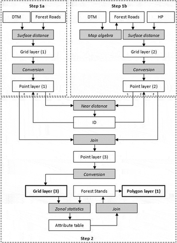
Step 1a: The goal of this step is winch distance calculation. The input source is DTM with spatial resolution of 50 cm and the forest road layer. For each cell of DTM raster layer, the distance over the terrain to the forest road was iteratively calculated. The result was the raster layer (Grid layer 1), which was converted into a vector point layer (Point layer 1).
Step 1b: The goal of this step is hauling distance calculation. The input source is DTM with spatial resolution of 50 cm and the forest road network with hauling places. Forest road was derived from ALS data, and the hauling places were taken from the terrain survey. Using the map algebra was assigned the value of DTM to every cell of roads. Thereafter for each cell of forest road raster layer, the distance over the terrain to the hauling place was iteratively calculated. The result was the raster layer (Grid layer 2), which was converted into a vector point layer (Point layer 2).
Step 2: the goal of this step is skidding distance calculation. The input source is layers from steps 1a and 1b. In these layers, the nearest points were identified and then the same identifier (ID) was assigned to them. Based on the added identifier, the layers were connected and then the distance calculated in steps 1a and 1b was summed. The resulting vector point layer (Point layer 3) was converted into the raster layer (Grid layer 3). After overlapping this raster layer with the layer representing the forest stands, using the zonal statistics tools, the skidding distance for every forest stand was calculated. After joining the resultant table with the vector layer representing forest stands, the output of step 2 was created (Vector layer 1).
Results
Forest roads mapping
Average density of points representing the terrain reached 1.4 ± 0.9 point/m2, whereby the average distance between them was 0.64 ± 0.18 m. Obviously the most classified terrain points, approximately 1.1 million, were acquired from the study area A, where the majority of the area was forest-free or with sparse forest. In contrast, the area with dense forest enabled the acquisition of approximately 0.4 million points in area B and 0.5 million points in area C.
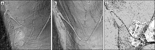
An overview of raster layers with the spatial resolution of 50 cm, created on the basis of the terrain points, is illustrated in . Illustrated raster layers were a basis for editing the forest roads network and provided the following three alternatives. The first one was a raster layer representing DTM (). This model proved to be very appropriate for the purpose of road vectorisation, as it recorded the terrain profile in detail. Roads in this profile were very well recognisable, except areas where the interpolation caused excessive generalisation of the surface. The raster layer representing the terrain slope of the previous model () proved to be an appropriate reference layer as well. Moreover this raster enabled the modification of shading that helped the better rendering of the line development. However, a direct classification of cells that would represent only the network according to a particular slope did not provide positive results. By the classification of the slope up to 10%, characterised in the standard STN 73 6108 as the boundary value for unpaved forest roads, it was not possible to identify the majority of roads mainly in flat areas. The technique of classification worked partially, however, only with the raster layer comprising values of maximum signal intensity (). It was proved that roads are characterised by a certain intensity interval according to which it is possible to classify them (roads in the figure are marked in black). This was true only in the case of roads situated in an open area, while in the forested area the characteristic intensity was interfered with by another surface from which the pulse was reflected (forested area is marked in grey).
Figure 3. Raster layers used for forest road vectorisation: (a) DTM; (b) Slope; (c) Pulse intensity.
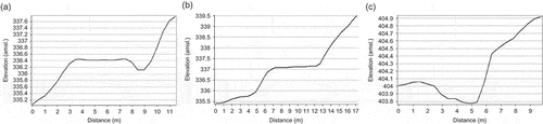
An overview of several terrain profiles is illustrated in . Individual illustrations present the details of the record of the terrain using ALS technology, which is also sufficient after carrying out the interpolation of point objects. In the profiles it is possible to recognise the surface of the road, bank or ditch slopes, as well as the built technical facilities of roads (road objects). Besides the fact that terrain profiles serve as a suitable aid tool during road identification, they are also suitable for analytical purposes. From them it is possible to derive data about the width and terrain profiles of the road, the height and condition of the slopes around the road, as well as the dimensions of the drainage facilities.
Figure 4. Examples of terrain profiles: (a) Haulage road with asphalt surface and longitudinal drainage; (b) Skid road with natural surface (good technical condition); (c) Skid road with natural surface (bad technical condition).
To provide for the vectorisation of the road network, the option selected from the analysed alternatives was the option of manual editing of linear objects in the reference raster layer representing DTM and slope with eventual additional use of cross-section terrain profiles. This option was the most optimal variant. In this way, approximately 11.7 km of roads were mapped. Of the overall study area, approximately 66% of the roads were identified exactly, 15% of roads were identified with minor problems, and 19% were identified with difficulties (). An average of 25% of roads was situated in forest-free areas, 22% was situated in areas with sparse forest and 54% in areas with dense forest (). The majority of the roads could be identified exactly, following the reference raster layers in the terrain model, in spite of the fact that their significant part was situated under the tree crown. An example of the visibility of forest road situated under forest vegetation is illustrated in . The figure renders the same part of the road in an aerial image and terrain model created on the basis of data from airborne scanning.
Figure 5. Qualitative characteristics of the road network in the study area acquired from ALS data: (a) The exactness of identification; (b) The position of the road with regard to the forest environment.
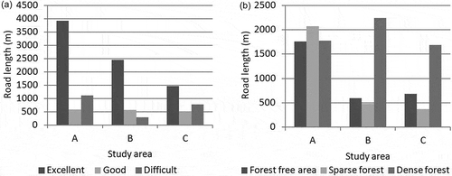
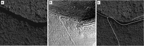
Figure 6. Example of the visibility of the forest road under vegetation cover: (a) Aerial image; (b) DTM from ALS; (c) Aerial image with edited forest road following the data from ALS.
An overview of the road network acquired from the scanning and terrain data is shown in . In recorded lengths differences are evident, whereby the method of scanning recorded more roads in area A and fewer roads in areas B and C than the method of terrain survey. This fact is the basic reason for detailed analyses of possible causes for the origination of such differences, including the evaluation of whether the level of forestation, different in areas A, B and C, affects the systematic deviation in over- or underestimation.
Table 2. Mapped road network in the study area in metres.
The results of the conformity comparison of mapped permanent forest roads, based on terrain survey with roads recorded from the ALS data, are given in (first step of analysis). They show that on average 87% of the forest roads are identical in the whole study area, whereas approximately one fourth of this portion is identical only in a certain part of the road, and approx. 6% has a significantly different position. That means that fewer than 13% of forest roads could not be identified from the ALS data. After selecting these roads, it was found out that these are exclusively skid roads with a natural surface situated under the forest vegetation, without built drainage system and bank and ditch slopes, and they are in bad condition. However, this finding cannot be generalised as some roads with similar attributes were identified.
Figure 7. Accuracy of identification: (a) Terrain data vs. ALS data; (b) ALS data vs. terrain data.
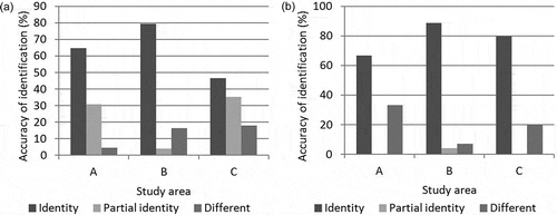
The results of the conformity comparison of mapped forest roads, based on terrain survey (only permanent forest roads) with roads recorded from the laser scanning data (permanent and temporary forest roads) are given in . They show that on average 80% of the roads are identical in the whole study area, whereas approximately 1% of this portion is identical only in a certain part of the road and approximately 16% has a significantly different position counter to the compared data. That means that the way of digitalisation the forest road network from the data acquired by laser scanning enabled the recording of approx. 20% more roads than by the terrain survey, which was aimed only at the permanent road network. At the same time, it is true that in this case these were roads exactly identified mainly in the terrain model, where only fewer than 33% of these roads were not exactly recognisable. With the additional terrain survey it was found that these were temporary forest roads and field paths used recently, and thus well recognisable in terrain.
Skidding distance calculation
The primary output is the raster layer where the cell values represent the shortest distance to the nearest forest road, and then to the nearest hauling place. The result is shown in . From this raster layer, a vector layer was created using zonal statistics tools, where each polygon represents a forest stand and the average skidding distance for each forest stand. The result is shown in . Based on the result, the average skidding distance in the study area is 1414 ± 954 m. 68% of forest stands are in a range of 460 m to 2368 m from the nearest hauling place.
Figure 8. Map of skidding distance: (a) Skidding distance – raster layer; (b) Average skidding distance – vector layer.

Discussion
Forest roads provide critical access for management of timber, wildlife, recreation and other forest values and also for forest protection. At the same time, forest roads are integral features of managed stands and landscapes that have microsite conditions and plant communities that differ from the surrounding patches of forest without forest floor and soil disturbances (Buckley et al. Citation2003). Precise planning of forest roads is one of the effective recommendations to prevent damages to the forest environment caused by roads, e.g. runoff, erosion (Saunders et al. Citation2002; Akbarimehr and Naghdi Citation2013). A basic prerequisite for optimal forest road network projection is a forest transport survey, which provides a view of the actual state of the forest roads in the analysed area. Based on skidding distance calculation results is evaluated state how the current forest road network opens up the analysed area.
Nowadays, forest transportation surveys are done mostly via terrain survey or a combination of terrain and aerial survey; aerial images are used. The terrain survey is the most expensive and also the most time-consuming part, due to the necessity for direct roads and crossroads measurement by GNSS, collection of attributes about roads and road objects, etc. The forest roads maps are not always precise, owing to the missing survey of transport conditions, and also, although this is a generalisation, they are not always the best information source for applications with an emphasis on accuracy (Tuček, Koreň, and Smreček Citation2012).
The aerial images are very reliable for the road inventory in forest-free areas and areas with sparse forest. In dense forest areas the roads are not visible on the aerial images. An alternative to aerial images could be ALS, which provides information also under forest cover. Therefore more roads could be identified using remote sensing techniques, in this way minimising the amount of terrain survey. ALS data provides the same or more reliable information about terrain or roads by comparing the traditional surveyed terrain data with data from ALS (Krogstad and Schiess Citation2004). However, inventory data, such as road material, condition of embankments and cut grades, road drainage condition, etc. are usually collected by terrain survey and are not likely to be extracted reliably from ALS data (White et al. Citation2010). On the other hand, detailed terrain models generated from ALS data enable better terrain analysis, e.g. evaluation of terrain profiles, state of road objects.
The analysis of the forest road network based on the data acquired from ALS on the example of the study area of 150 ha has proven good usability of this technology of remote sensing of the Earth within solving the analysed topic. Applying the terrain profiles, DTM and slope raster layers enable the exact identification of the majority of forest roads. These two raster layers proved to be optimal for manual identification and vectorisation of linear objects. Only approximately 13% of all permanent roads could not be recorded in the study area from ALS data. These were roads used exclusively for wood skidding, situated under dense forest vegetation, with a natural surface in bad technical condition, and they did not have any drainage system or bank or ditch slopes. At the same time it was possible to record approximately 20% of the roads that were not recorded within the terrain survey of the permanent forest road network. These were mainly temporary forest roads or field paths characterised by an unpaved road surface without drainage elements, all situated under the treetops. Because roads were visible under the forest canopy, we can say that forestation is not the most significant effect that affects visibility and identification of the roads from ALS data. A more important factor is the terrain profile or the visibility of the road line in the profile – quality of the DTM. At the same time it is valid that the visibility of the line is influenced mainly by the presence and condition of individual elements of the road network but also actual utilisation of the particular road. That means that the better the condition of the road, slopes and drainage is, or when the road is regularly used, the better the identification of the road in the terrain model.
A similar theme was dealt with by, for example, White et al. (Citation2010), who digitised all 30 km of road and trail features on the study area from ALS data. 95% of roads were derived from ALS data, digitised within 1.5 m from the terrain surveyed centreline. The remaining 5% of road length was located further than 1.5 m from the centreline. The maximum distance did not exceed 2.0 m. Also, Rieger et al. (Citation1999) achieved a high level of accuracy using roads and break lines identification. The discrepancies lay in the range of 1–2 m. David et al. (Citation2009) found that the shift was smaller than 3 m. The road inventory using ALS was also made in urban areas. The algorithm derived by Boyko and Funkhouser (Citation2011) achieved 86.3% precision of road identification from a point cloud in urban conditions. Chen and Lo (Citation2009) achieved more than 98% successful automatic road network reconstruction in an urban area.
Forest opening is evaluated by forest road spacing, which directly affects the distance between the place of felling trees and the place from where wood is transported from the forest. It is necessary to determine the optimal road density to minimise the combined yarding and road construction costs to secure efficiency of transport on forest roads (Ghaffariyan et al. Citation2010). The average skidding distance is unique for every calculated area. Variables such as technology (animal, tractor or cable skidding), skidding downhill or uphill, and the number of hauling places, have an influence on the average skidding distance. Information about the road network, forest stands, average skidding distance, logging mechanisms and geomorphology can be used to find the optimal technology for individual forest stands, on the basis of economy and ecology, using GIS tools and fuzzy logic (Suchomel et al. Citation2009). In the past the calculation of skidding distance and forest opening evaluation was realised from analogue maps and the results were generalised. Nowadays strong visualisation, analytic and programming tools of geoinformatics are used for these purposes.
This solution was presented in this article, where investigation of skidding distance was done in an automated way and based on precise data acquired from ALS. This method was applied for every forest stand in the analysed area. The average skidding distance on the study area is 1414 m. A map representing skidding distance for every forest stand was created. The suggested solution presented in the article proved to be efficient because it is based on automated processing of precise data acquired from ALS.
Conclusion
The main mission of the forest transport survey is to get quantitative and qualitative information about the forest road network in the analysed area. This in particular concerns information regarding the position, length and damage of forest roads, based on which the forest opening of the area is subsequently evaluated by calculated skidding distance. This article presents a solution in which the inventory of the road network performs the manual editing of the data based on laser scanning (ALS), and the subsequent calculation of the skidding distance being automated by the developed algorithm in the GIS. In this way this article shows the universal solution of forest transport survey, which is also evaluated on the study area of the University Forest Enterprise of the Technical University in Zvolen.
Although the forest road network is important, nowadays there is often no up-to-date information about the condition of roads. In the Slovak Republic, the survey of transport conditions was part of the forest plan. This survey gives a basic overview of the forest road network condition, and it was also used for forest opening planning. No transportation condition survey was made since 1993 (Tuček, Koreň, and Smreček Citation2012). The lack of up-to-date information about the forest road network currently leads to problems in landscape analysis, e.g. in flood management, fire protection.
The results of evaluation of using ALS when mapping roads within the study area have proven that this technology has prospects. However, these results cannot be considered universal, and it is necessary to provide for continual research. It is inevitable to examine the possibilities and limitations in different geomorphologic and biological conditions. At the same time, it is important to deal with the area of automatic procedures development, which will further increase the effectiveness of this activity. The resulting map of the area of forest roads can be used for automated skidding distance calculation, which will give the full overview of forest opening in the area.
Funding
This publication is the result of implementation of the project: Centre of Excellence “Decision support in forest and country”, ITMS [grant number 26220120069], supported by the Research & Development Operational Programme funded by the ERDF.
References
- Ahokas, E., H. Kaartinen, and J. Hyppä. 2003. “A Quality Assessment of Airborne Laser Scanner Data.” In 3-D Reconstruction from Airborne Laserscanner and InSAR Data, ISPRS Archives, Vol. XXXIV, Part 3/W13, edited by H.-G. Maas, G. Vosselman, and A. Streilein, Dresden, October 8–10.
- Akbarimehr, M., and R. Naghdi. 2013. “Assessing the Relationship of Slope and Runoff Volume on Skid Trails (Case Study: Nav 3 District).” Journal of Forest Science 58 (8): 357–362.
- Asnera, G. P., M. Keller, R. Pereira, J. Zweeded, and C. Johan. 2002. “Remote Sensing of Selective Logging in Amazonia Assessing Limitations Based on Detailed Field Observation Landsat ETM +, and Textural Analysis.” Remote Sensing of Environment 80: 483–496.
- Auclair-Fortier, M. F., D. Ziou, C. Armenakis, and S. Wang. 2000. “Automated Correction and Updating of Road Databases from High-Resolution Imagery.” Canadian Journal of Remote Sensing 27: 76–89.
- Bowling, L. C., and D. P. Lettenmaier. 1997. Evaluation of the Effects of Forest Roads on Streamflow in Hard and Ware Creeks, Washington, 378 p. Seattle, WA: University of Washington. Water Resources Series Technical Report: 202.
- Boyko, A., and T. Funkhouser. 2011. “Extracting Roads from Dense Point Clouds in Large Scale Urban Environment.” ISPRS Journal of Photogrammetry and Remote Sensing 66 (6): S2–S12.
- Buckley, D. S., T. R. Crow, E. A. Nauertz, and K. E. Schutz. 2003. “Influence of Skid Trails and Haul Roads on Understory Plant Richness and Composition in Managed Forest Landscapes in Upper Michigan, USA.” Forest Ecology and Management 175 (1–3): 509–520.
- Chen, L. C., and C. Y. Lo. 2009. “3D Road Modeling via the Integration of Large-Scale Topomaps and Airborne LiDAR Data.” Journal of the Chinese Institute of Engineers 32 (6): 811–823.
- Cibulka, M., and T. Mikita. 2011. “Using of Data from Aerial Laser Scanning for Digital Terrain Modeling in Forest Stands.” In Progressive Methods for Processing of Incidental Fellings, edited by J. Tuček, J. Suchomel, M. Gejdoš, and J. Jurica, 94–102, Zvolen, October 19–20 (in Czech).
- David, N., C. Mallet, T. Pons, A. Chauve, and F. Bretar. 2009. “Pathway Detection and Geometrical Description from ALS Data in Forested Mountainous Area.” In Proceedings of Laser Scanning 2009, edited by F. Bretar, M. Pierrot-Deseilligny, and G. Vosselman, 242–247, Paris, September 1–2.
- Deschenes, F., D. Yiou, and M. F. Auclair-Fortier. 2004. “Detection of Lines, Line Junction and Line Terminations“. International Journal of Remote Sensing 25 (3): 511–535.
- García-Balboa, J. L., J. F. Reinoso-Gordo, and F. J. Ariza-López. 2013. “Automated Assessment of Road Generalization Results by Means of an Artificial Neural Network.” GIScience & Remote Sensing 49 (4): 558–596.
- Ghaffariyan, M. R., K. Stamfer, J. Sessions, T. Durston, M. Kuehmaier, and C. H. Kahzian. 2010. “Road Network Optimization Using Heuristic and Linear Programming.” Journal of Forest Science 56 (3): 137–145.
- Gumus, S., H. H. Acar, and D. Toksoy. 2008. “Functional Forest Road Network Planning by Consideration of Environmental Impact Assessment for Wood Harvesting.” Environmental Monitoring and Assessment 142 (1–3): 109–116.
- Hodgson, M. E., and P. Bresnahan. 2004. “Accuracy of Airborne Lidar Derived Elevation: Empirical Assessment and Error Budget.” Photogrammetric Engineering and Remote Sensing 70 (3): 331–339.
- Hyyppä, J., H. Hyyppä, M. Maltamo, X. W. Yu, E. Ahokas, and U. Pyysalo. 2003. “Laser Scanning of Forest Resources – Some of the Finish Experience.” In Proceedings of the Scandlaser Scientific Workshop on Airborne Laser Scanning of Forests, edited by J. Hyppä, E. Naeset, H. Olsson, T. Granqvist, and H. Reese, 53–60, Umea, September 3–4.
- Klč, P., L. Bránka, and J. Žáček. 2010. “Research of the Structure of Forest Road Network in Chosen Model Area.” Lesn. Čas. – Forestry Journal 56 (3): 295–304 (in Czech).
- Klimánek, M., and T. Mikita. 2009. “Analysis of the Accuracy of GPS Measurement at the Field Research.” In Chřiby 2009 – Landscape, Forest, Water, edited by K. Rebrošová and J. Schneider, 52–62, Bukovanský mlýn, May 6–7 (in Czech).
- Krogstad, F., and P. Schiess. 2004. “The Allure and Pitfalls of Using LiDAR Topography in Harvest and Road Design.” Proceedings of The International Mountain Logging Conference, Vancouver, BC, June 13–16.
- Lee, H., K. C. Slatton, and H. Jhee. 2005. “Detecting Forest Trails Occluded by Dense Canopies Using ALSM Data.” In Proceedings of the Geoscience and Remote Sensing Symposium, 3587–3590, Seoul, July 25–29.
- Messingerová, V., and J. Tajboš. 2007. “Possibilities of Some Optimise Methods in Harvesting Process of Forestry Management.” In Logistics and Distribution Systems: Proceedings of the International Conference, 80–86, Zvolen, May 17–18 [in Slovakian].
- Phillips, R., M. West, N. Saliendra, B. Rundquist, and D. Pool. 2012. “Prediction of Senescent Rangeland Canopy Structural Attributes with Airborne Hyperspectral Imagery.” GIScience & Remote Sensing 50 (2): 133–153.
- Rieger, W., M. Kerschner, T. Reiter, and F. Rottensteiner. 1999. “Roads and Building from Laser Scanner Data in a Forest Enterprise.” In Mapping Surface Structure and Topography by Airborne and Spaceborne Lasers, Proceedings of the ISPRS Workshop at LaJOLLA, International Archives of Photogrammetry and Remote Sensing, edited by B. M. Csathó, 185–191, LaJolla, CA, November 9–11.
- Sačkov, I., and M. Kardoš. 2013. “Point Clouds from Airborne Laser Scanning and Aerial Images for Forestry Application.” In 33. Wissenschaftlich-Technische Jahrestagung Der DGPF, 8 p., Freiburg. February 27–March 1.
- Saunders, S. C., M. R. Mislivets, J. Chen, and D. T. Cleland. 2002. “Effect of Roads on Landscape Structure within Nested Ecological Units of the Northern Great Lakes Region.” Biological Conservation 103 (2): 209–225.
- Scherer, R., and R. G. Pike. 2003. Effects of Forest Management Activities on Streamflow in the Okanagan Basin: Outcomes of a Literature Review and a Workshop, 52p. Kamploops, BC: Forrex.
- Smreček, R., and Z. Danihelová. 2013. “Forest Stand Height Determination from Low Point Density Airborne Laser Scanning Data in Rožňava Forest Enterprise Zone (Slovakia).” iForest 6: 48–54. Accessed January 21. http://www.sisef.it/iforest/contents?id=ifor0767-006
- Smreček, R., and M. Sedliak. 2011. “Database of Forest Road Network and Purpose Objects on Area of Technical University Forest Enterprise by Geoinformation Technology.” Acta Facultatis Forestalis Zvolen 53 (2): 127–142 (in Slovakian).
- STN 73 6108. “Forest Transportation Network.” Slovenský ústav technickej normalizácie, Bratislava, July 2000, No. pub. 14483, 36 p. [in Slovakian].
- Storck, P., L. Bowling, P. Wetherbee, and D. Lettenmaier. 1998. “Application of a GIS-Based Distributed Hydrology Model for Prediction of Forest Harvest Effects on Peak Stream Flow in the Pacific Northwest.” Hydrological Processes 12 (6): 889–904.
- Suchomel, J., M. Slančík, J. Tuček, and M. Koreň. 2009. Optimization of Terrain and Technological Standardization in GIS Environment. Technical University in Zvolen, Zvolen, 117 p. (in Slovakian).
- Tuček, J., M. Koreň, and R. Smreček. 2012. “Creation and Application of Forest Road Network Database in Geoinformation Technologies Environment.” Lesn. Čas. – Forestry Journal 58 (1): 45–56 (in Slovakian).
- Tuček, J., and J. Suchomel. 2003. Geoinformatics in Providing Access to Forests and Optimization of Logging and Hauling Technologies – Possibilities, State and Perspectives. Technical University in Zvolen, Zvolen, 166 p. (in Slovakian).
- White, R. A., B. C. Dietterick, T. Mastin, and R. Strohman. 2010. “Forest Roads Mapped Using LiDAR in Steep Forested Terrain.” Remote Sensing 2 (4): 1120–1141.