
 ?Mathematical formulae have been encoded as MathML and are displayed in this HTML version using MathJax in order to improve their display. Uncheck the box to turn MathJax off. This feature requires Javascript. Click on a formula to zoom.
ABSTRACT
The difficult, time-consuming, and imbalanced acquisition of landslide inventories in complex and heterogeneous large areas often results in limited predictive performance for most statistical landslide spatial prediction methods. Although partial transfer learning methods have produced reliable predictive results and successfully implemented knowledge transfer between data-rich and data-scarce areas, most of these methods generally only extract inadequate environmental features and lack the ability to interpret when, what, and how to effectively transfer knowledge to other regions with limited data. In this paper, a heterogeneous transfer learning method considering feature representations and environmental consistency, which features robustness, similarity, and transferability, is proposed for landslide spatial prediction. Specifically, we trained a stacked autoencoder (SAE) to extract more nonlinear features among environmental factors, and added an environmental similarity criterion to the transfer adaptation boosting (TrAdaBoost) algorithm to minimize feature dissimilarities and avoid negative transfer in different scenarios. To evaluate the robustness of the proposed method, we first selected two target areas (Lushan County and Luding County, China) and a source area (Wenchuan County, China) as case study areas. Then, we directly combined the source area and target area as an additional dataset without considering transfer learning to validate the significance and necessity of the proposed method. The area under the receiver operating characteristic curve (AUC) of the two target regions for the proposed method were 0.920 and 0.972, respectively, which were greater than those of the traditional TrAdaBoost (0.909 and 0.969, respectively), SAE (0.790 and 0.937, respectively), and random forest (0.915 and 0.966, respectively) methods. Furthermore, the AUC values of the SAE (0.851 and 0.900) and random forest (0.890 and 0.935) models based on the expanded datasets were also lower than those of the proposed method. Therefore, the experimental results show that the proposed method can be generalized well due to its efficient utilization and high adaptability. Moreover, the proposed method can not only be applied to emergency rescue and disaster prevention but can also offer a promising way to improve landslide predictions of models with incomplete landslide inventories.
GRAPHICAL ABSTRACT

1. Introduction
Climate change is expected to increase the duration, frequency, and intensity of extreme weather events, such as heavy precipitation and heat waves, subsequently affecting landslide occurrences and threatening human lives and property (Chowdhuri et al. Citation2020, Citation2021; Froude and Petley Citation2018; Gariano and Guzzetti Citation2016; Seneviratne et al. Citation2012). In addition, strong earthquakes are also a main cause of landslide occurrences, which cause slope instability and generate a large number of loose deposits, leading to landslides and debris flows under the further action of heavy rainfall. Landslide spatial prediction (LSP), which refers to the spatial probability of landslide occurrence, is therefore extremely valuable for landslide prevention and mitigation (Chen et al. Citation2024; Huang et al. Citation2020a; Reichenbach et al. Citation2018; Ruidas et al. Citation2021, Citation2022, Citation2023; Yao et al. Citation2023, Citation2024).
In recent decades, an increasing number of LSP methods have been proposed to generate LSP results for different areas (Chen et al. Citation2022; Huang et al. Citation2020a; Jia et al. Citation2021; Lin et al. Citation2021; Ouyang et al. Citation2024; Pham et al. Citation2019b; Van Den Eeckhaut et al. Citation2011; Wang et al. Citation2022), including random forests (Chowdhuri et al. Citation2022; Sun et al. Citation2020), frequency ratios (Huang et al. Citation2022a; Pal and Chowdhuri Citation2019), convolutional neural networks (Panahi et al. Citation2021; Zhao et al. Citation2021), Bayesian generalized linear models (Pal et al. Citation2022), analytic hierarchy processes (Moragues et al. Citation2021; Pal, Das, and Malik Citation2019), support vector machines (Pham and Prakash Citation2019; Pham et al. Citation2019a), artificial neural networks (Chen et al. Citation2017), and U-Net convolutional networks (Bhuyan et al. Citation2023). These methods are generally classified into three categories: knowledge-driven, physically-driven, and data-driven methods (Corominas et al. Citation2014). Data-driven methods are much more convenient and high efficiency when expert knowledge and detailed geotechnical parameters are difficult to obtain in large areas (Corominas et al. Citation2014; Park et al. Citation2019; Zhao et al. Citation2023b), the accuracy of which is strongly correlated with the richness of the landslide inventory and the selection of environmental factors. However, data-driven methods also exhibit significant limitations in data-scarce regions and heterogeneous environments due to the problem of landslide inventory shortages (Ai, Sun, and Chen Citation2022; Al-Najjar et al. Citation2021; Chen et al. Citation2020; Hong et al. Citation2019; Huang et al. Citation2022a). Specifically, some regions with high altitudes, hidden features, and dense vegetation cover may hinder the investigation of landslide, and limited or imbalanced landslide data may occur, leading to inaccurate LSP results (Zeng et al. Citation2022). Although field investigation, visual interpretation of satellite or aerial images, identification of low-altitude unmanned aerial vehicle images, and semantic segmentation methods are used to generate accurate landslide inventory maps, these approaches are time-consuming, labor-intensive, expensive, and overlap in practical applications (Dai et al. Citation2022; Steger et al. Citation2017; Wang, Wang, and Zhang Citation2022; Zhao et al. Citation2023a). Thus, there is a challenge in how to achieve effective sharing and application between limited landslide inventories in different regions. Whenever feasible, it is essential to consider knowledge transfer or sharing between data-rich and data-limited regions when constructing LSP models. This contributes to enhancing the reuse efficiency of landslide data and the robustness of the model (Chen et al. Citation2020; Wang, Wang, and Zhang Citation2022; Zhu et al. Citation2020, Citation2022). However, many studies have overlooked the opportunity to learn general and transferable knowledge from similar environments. Instead, they directly utilize limited or unbalanced landslide inventories for LSP in heterogeneous environments (Conoscenti et al. Citation2016; Hong et al. Citation2019; Wang et al. Citation2022). Consequently, there is a need to develop transferable LSP methods that overcome the limitations of data deficiency.
As such, transfer learning has received much more attention due to its great potential in solving limited-data problems and facilitating knowledge transfer between the source domain and the target domain (Xu et al. Citation2022). For instance, an integrated deep learning and transfer learning method was proposed to generate LSP results in Hong Kong and achieved high prediction accuracy (Wang, Goetz, and Brenning Citation2022). The transfer adaptation boosting (TrAdaBoost) algorithm based on instance transfer was adopted to transfer useful information from different areas to improve the performance of an LSP model. Unsupervised transfer learning based on domain adaptation was applied to address the challenge of model transfer (Wang, Goetz, and Brenning Citation2022; Wang, Wang, and Zhang Citation2022). A spatial case-based reasoning method and its improvements were developed to improve the transferability and prediction accuracy of the model compared with other machine learning methods (Zhao et al. Citation2021, Citation2023b). However, in the construction of an LSP model, most transfer learning methods do not consider intrinsic differences in matching landslide datasets between the source and target domains and have directly expanded the entire landslide dataset in other areas to train the LSP model, which ignores intrinsic heterogeneity among different environmental characteristics and can lead to negative transfer due to its excessive transferability. Some studies have shown that the homogeneous distribution of landslide data is crucial for the performance of transfer learning methods. Therefore, there are still gaps regarding how to represent environmental characteristics and how to filter transferable landslide inventories in data-rich regions.
Thus, in this study, the key objective is to propose a heterogeneous transfer learning method that considers feature representation and environmental consistency to improve the robustness and transferability of an LSP model. In contrast to previous studies, we first trained a stacked autoencoder (SAE) to extract more representations of nonlinear features in an unsupervised manner, and an environmental similarity criterion was implemented to filter valuable landslide inventories. Then, the LSP results were predicted by three traditional machine learning methods, and their performances were evaluated and compared across two target study areas. Finally, the importance of feature representation and environmental consistency was further discussed, followed by the presentation of some future work.
2. Study area and data
Wenchuan County, Lushan County, and Luding County, which are located in Sichuan, China, were used as the source area and two target areas, respectively. The reasons for selecting these areas are their specific geographic locations, experience with intense earthquakes, and frequent occurrence of geological disasters (Zhao and Chen Citation2023; Zhao et al. Citation2021). This section provides a brief introduction to the study areas, landslide inventories, and corresponding environmental factors.
2.1. Source and target areas
Wenchuan County, with an area of approximately 8,820 km2, is in the northwestern plateau region of Sichuan Province, China. This region is situated in the Longmenshan tectonic belt on the eastern margin of the Qinghai Tibet Plateau and mainly comprises magmatic rocks, including granite, diorite, and gabbro (Wang et al. Citation2021). The area is characterized by three main faults: the Longmenshan Fault, Central Fault, and Houshan Fault (Wang et al. Citation2021). On 12 May 2008, an 8.0-magnitude earthquake with a focal depth of more than 20 km struck Wenchuan County, triggering extensive collapses, landslides, and debris flows, which severely disrupted the local economy and transportation infrastructure (Cui et al. Citation2021; Qi et al. Citation2010; Zhang et al. Citation2022). Consequently, the abundant landslide inventory in this area can serve as the source area for our study.
Lushan County is situated in the northeastern part of Ya’an, at the western edge of the Sichuan Basin in China. It features altitudes ranging from 527 m to 5,289 m, with an average annual rainfall of approximately 102 mm. Lushan County experienced a series of powerful earthquakes (Ms ≤ 7.0) on 20 April 2013, and 1 June 2022. These earthquakes altered the internal forces acting on the mountain slopes, resulting in frequent landslides in the study zone.
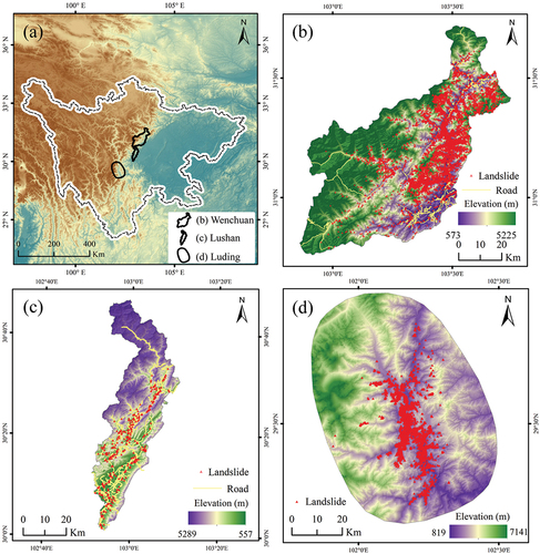
Luding County lies in a transitional zone between the western Sichuan Plateau and Sichuan Basin, located in southeastern Ganzi, Sichuan, China. The terrain varies from high in the west to low in the east and is shaped by river and glacial erosion, resulting in alpine and canyon landforms. Geological features, including faults and folds, are prominent in Luding County, and are characterized by active tectonic movements. The region has experienced numerous earthquakes, with 22 earthquakes above Ms 6.0 and 8 earthquakes above Ms 7.0 since 1700. Following the 2008 Wenchuan earthquake and the 2013 Lushan earthquake, the Kulun stress in the Xianshuihe fault zone notably increased, increasing the risk of major seismic events. On 5 September 2022, Luding County was struck by a Ms 6.6 earthquake, with a depth of 16 km and a maximum intensity of IX degrees. The earthquake resulted in injuries, casualties, and extensive damage to roads, bridges, and infrastructure. Consequently, it is important for decision-makers to quickly produce reliable landslide susceptibility map. displays the geographic location and landslide distribution of the source and target areas, respectively.
Figure 1. Locations of the study areas and landslide distributions. (a) The geographic location of the three study areas in Sichuan Province. (b) Wenchuan County as a source area. (c) Lushan County as a target area. (d) Luding County as a target area.
2.2. Data used
A comprehensive landslide inventory and relevant environmental factors are pivotal in elucidating the relationships between landslide occurrences and environmental conditions. The proposed method primarily emphasizes the representation and consistency of environmental factors, thus focusing on earthquake-induced landslides rather than those triggered by multiple events. Accordingly, we curated and filtered 5,447 historical earthquake-induced landslides in Wenchuan County, 353 in Lushan County, and 5,007 in Luding County based on historical records, field surveys, and remote sensing image interpretation (Huang et al. Citation2024). These landslides predominantly occurred in 2008, 2013, and 2022 in Wenchuan, Lushan, and Luding Counties, respectively. outlines the specifics of landslides in each study area, encompassing attributes such as name, type, volume, time, triggering conditions, and locations. Moreover, an equal number of non landslide samples were randomly selected from landslide-free areas to balance the overall sample distribution in both the source and target areas (Pham et al. Citation2019a).
Table 1. Details of landslides in the three study areas.
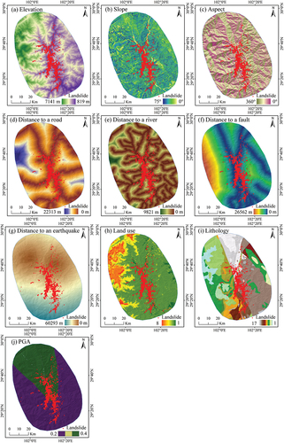
The selection of landslide-related environmental factors is crucial for the development of an effective LSP model that encompasses geological, topographic, hydrological, climatic, and triggering factors (Zhao et al. Citation2021). These factors not only influence landslide occurrence but also contribute to the spatiotemporal distribution of landslides. Despite the absence of a consensus on a definitive set of factors, our selection was informed by previous literature and the environmental context of both the source and target areas. Elevation, slope, aspect, distance to roads, rivers, faults, and earthquakes, land use, lithology, and peak ground acceleration (PGA) were identified as pertinent landslide-related environmental factors. Elevation, aspect, and slope data were derived from the ASTER Global Digital Elevation Model at a spatial resolution of 30 m × 30 m. Lithology and fault data were sourced from the 1:500,000 geological map of China, while river and road data were obtained from the 1:1000,000 national basic geographic information dataset. The land use data were derived from Landsat images via the Google Earth Engine platform, and the earthquake data were collected from the United States Geological Survey. Moreover, determining the appropriate spatial resolution and mapping unit for LSP is paramount. To this end, we considered the resolution of conditioning factors, data availability, landslide volume, and insights from previous studies (Abbaszadeh Shahri et al. Citation2019; Ba et al. Citation2018; Chang et al. Citation2020; He et al. Citation2021; Huang et al. Citation2024; Huang et al. Citation2020a; Pham et al. Citation2019a; Youssef et al. Citation2015). Thus, all the data layers were uniformly resampled and reclassified to raster layers with a spatial resolution of 30 m × 30 m. , and illustrate the landslide-related environmental factors in both the source and target areas, providing a visual representation of the data for analysis and interpretation.
Figure 2. Landslide-related environmental factors in Wenchuan County.
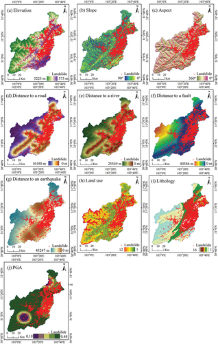
Figure 3. Landslide-related environmental factors in Lushan County.
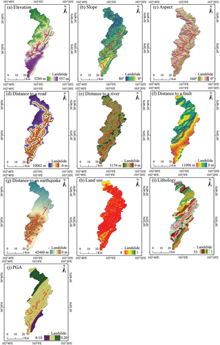
Figure 4. Landslide-related environmental factors in Luding County.
3. Methodology
3.1. Frequency ratio analysis
Frequency ratio (FR) analysis is a popular and traditional method for LSP (Lee, Ryu, and Kim Citation2007; Pal and Chowdhuri Citation2019; Vakhshoori and Zare Citation2016) and is employed to assess the influence of predisposing factors on landslide susceptibility (Chowdhuri et al. Citation2021; Pal, Das, and Malik Citation2019; Ruidas et al. Citation2021, Citation2022). Calculating the FR value enables the estimation of the likelihood of landslide occurrence within a target area under the influence of these factors. Typically, a higher FR indicates a greater probability of landslide occurrence, while a lower FR suggests a diminished correlation (Chang et al. Citation2020). The FR value can be calculated as:
where ,
, and
are the number of landslides, number of grid pixels, and frequency ratio value in the ith subclass of the jth environmental factor, respectively. In addition, n denotes the number of subclasses in the ith influencing factor.
3.2. Kullback-leibler divergence analysis
To meet the requirements of a transfer learning method and avoid negative transfer in different scenarios, we used the Kullback-Leibler (KL) divergence method to describe similarities between the source area and target area in terms of the distributions of two variables (Kullback and Leibler Citation1965). The equation for KL is as follows:
where and
represent the probability distributions of the two variables. The
value is greater than or equal to 0. Smaller KL values represent greater similarities between two independent variables.
3.3. Framework of the proposed transfer learning method
The purpose of this paper is to propose a transfer learning method that considers feature representation and environmental consistency to improve the robustness and transferability of LSPs. The framework of the proposed method is shown in . The procedure can be divided into three steps: environmental feature representation in source and target areas, environmental similarity criterion creation, and instance-based transfer learning.
Figure 5. The framework of the proposed transfer learning method.
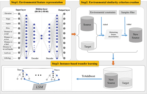
3.3.1. Environmental feature representation
The initial step involves acquiring a compressed representation of environmental factors through unsupervised learning, thereby enhancing feature representation within a lower-dimensional space. The stacked autoencoder (SAE), a specialized form of a multilayer perceptron, serves this purpose. In this study, the SAE model was utilized not only for reconstructing the features of landslide-related environmental factors but also for mitigating the simplistic use of original data (Nam and Wang Citation2020). Moreover, the middle layer, characterized by a lower dimension, aids in preventing overfitting and facilitates dimension reduction scenarios (Charte et al. Citation2018; Hinton and Salakhutdinov Citation2006). The SAE model comprises multiple autoencoders, in which the output of each layer connects to the input of the preceding layers, configured as 80-50-2-50-80 (refer to ). Five hidden layers, employing the rectified linear unit (ReLU) function, are utilized in the middle layer for encoding the input and decoding the output. The model underwent 8,000 training steps with a batch size of 32. An adaptive learning rate, implemented through the Adam optimizer, was utilized to refine the model weights. Consequently, this process yields a new feature representation of landslide-related environmental factors in both the source and target areas, which is essential for subsequent steps.
3.3.2. Environmental similarity criterion creation
The primary objective of this step is to discern and filter pertinent knowledge within the source area, recognizing that not all samples within the source area may be suitable for transfer (Jiang and Zhai Citation2007). The process of transferring knowledge from the source area to the target domain entails inherent uncertainties regarding what, when, and how this knowledge is effectively transferred. Given the insights gleaned from prior research and the significance of environmental consistency (Zhao et al. Citation2023b), we initially devised the environmental similarity criterion (ESC) to discern valuable landslide samples within the source domain. The identified samples within the source area are considered a new source for further analysis. Its purpose is to minimize the difference between the source and target domains and further prevent negative transfer. Specifically, an ESC method measures transferability by considering the environmental consistency between the source and target domains. We assumed two landslide collections among the source and target areas, CS ={L1 (,
, …
), L2 (
,
, …
), … Ln (
,
, …
)} and Ct ={L1 (
,
, …
), L2 (
,
, …
), … Lm (
,
, …
)}. Ln (
,
, …
) is the environmental factor collection of the nth landslide. n and m are the numbers of landslides for the Cs and Ct collections, respectively. The equations for ESC are as follows:
where Si denotes the similarity coefficient of the ith landslide-related environmental factor of a landslide between source domain s and target domain t. and
denote the ith landslide-related environmental factor corresponding to the landslide collections (s and t). Fmax is the maximal value of ith landslide-related environmental factor in the target domain t. Wi denotes the weight of the ith landslide-related environmental factor. S and i are the sum of Si and the number of landslide-related environmental factors, respectively. Finally, we filter a new subset with more similar environments according to a user-defined threshold
. Thus, a new collection (NC) is generated by filtering the original source domain (s) based on EquationEq. (5)
(5)
(5) . A landslide in the source domain belongs to the NC when S is greater than the threshold. In this study, we set multiple thresholds for repeated experiments and set 0.98 as the optimal threshold
according to the best performance of the model.
3.3.3. Instance-based transfer learning
The third step employs an instance-based transfer learning method to formulate LSP results based on the new source domain established in Step 2. Typically, a transfer learning method is initially trained on a substantial volume of labeled data to acquire general features, knowledge, relationships, or weights. Subsequently, this acquired general knowledge is transferred from data-abundant regions to data-limited areas to address specific tasks (Pan and Yang Citation2010). Transfer learning methods can be categorized into four main types: instance-based transfer learning, feature representation-based transfer learning, parameter-based transfer learning, and relational knowledge-based transfer learning. A fundamental assumption of instance-transfer learning is that the mechanism of landslide occurrence (e.g. landslide distribution characteristics) in some source domains is similar to that in the target domain, and knowledge transfer is realized by adjusting the weights of the samples between the source domain and the target domain. Conversely, the other three transfer methods realize knowledge transfer according to the feature distribution, parameter sharing and relational understanding. Consequently, in this study, we selected the TrAdaBoost algorithm based on instance-transfer learning to carry and transfer knowledge from the source domain, and then combined it with a random forest as a base classifier to train a robust LSP model in the target domain (Dai et al. Citation2007). A more detailed flowchart of the TrAdaBoost algorithm is shown in (Dai et al. Citation2007).
Table 2. TrAdaBoost algorithm.
3.4. Model evaluation
In this study, we propose a heterogeneous transfer learning method considering feature representation and environmental consistency to improve the robustness and transferability of LSPs. To validate the robustness of the proposed method and explore the influence of feature representation on similarity calculations, we developed three models for comparison: The TrAdaBoost-RF, SAE-RF, and RF models. The TrAdaBoost-RF model is trained by traditional TrAdaBoost without considering feature representation and environmental consistency. The SAE-RF model is developed by combining a stacked autoencoder with a random forest as a base classifier. RF is generated by a random forest method. For LSP model training, the experimental dataset was divided 7:3 by using stratified random sampling, of which 70% was used for model training and 30% was used for model validation (Zhao et al. Citation2023b). Finally, we used the area under the receiver operating characteristic curve (AUC) and statistical indicators to assess the performance of the proposed method based on 10-fold cross-validation.
4. Results
4.1. Quantification analysis of the landslide-related environmental factors
The collinearity analysis of landslide-related environmental factors for the three study areas is illustrated in . The quantification analysis of factors serves to mitigate noise and indicates that all factors demonstrate sufficient independence. It is evident that no linear correlation exists among the 10 landslide-related environmental factors in both the source and target areas, as evidenced by the variance inflation factor (VIF) values of all factors being less than 10. This suggests that all predisposing factors can be effectively incorporated into the development of the LSP model.
Figure 6. Collinearity analysis of the landslide-related environmental factors in the three study areas.
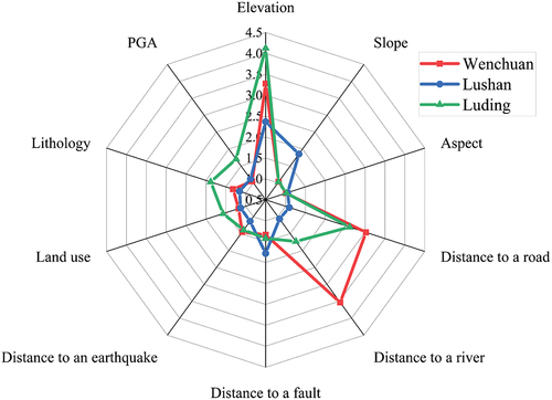
The mechanism of landslide occurrence may be different for different study areas. In , the FR values and classification schemes for each predisposing factor are presented. The different classifications of each landslide-related environmental factor exhibit varying effects on landslide occurrence, as indicated by their distinct FR values in both the source and target areas. Notably, in Wenchuan County, a greater frequency of landslides is inclined to occur in the middle altitude range (900–2500 m), while fewer landslides occur in low altitude areas. Similar trends are observed in Lushan County and Luding County. Conversely, the slope analysis reveals a greater likelihood of landslide occurrence between 80° and 90° in Wenchuan County, 0° and 24° in Lushan County, and between 26° and 49° in Luding County. These results underscore the utility of FR analysis in addressing issues of feature dissimilarities.
Table 3. Frs of landslide-related environmental factors.
A similar feature distribution between the source and target areas contributed to developing a better LSP result to avoid a negative transfer. presents the Kullback-Leibler (KL) divergence values for each landslide-related environmental factor. The results indicate that the feature distributions across the source and target areas are not entirely consistent. In particular, the probability distributions of distance to a road, distance to a river, and distance to a fault exhibit significantly higher KL values, suggesting notable differences in their distributions. Consequently, the presence of feature dissimilarities, especially in these variables, may lead to negative transfer when directly applying them to transfer learning methods.
Table 4. KL values of landslide-related environmental factors.
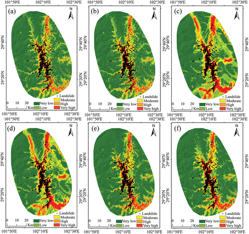
4.2. Landslide susceptibility mapping
summarizes the 12 LSP models used to evaluate the performance of the proposed transfer learning method. These models are compared based on their ability to predict landslide susceptibility indices (LSIs), which are classified into five categories using the natural break method: very low (0–0.13), low (0.13–0.37), moderate (0.37–0.60), high (0.60–0.82), and very high (0.82–1.0). Obviously, all the landslide susceptibility maps (LSMs) have similar spatial patterns. Specifically, the very high and high susceptibility levels are mainly distributed along rivers and roads.
Table 5. Performance comparison among the 12 methods.
shows a slight difference for the susceptibility levels. In addition, it must be emphasized that a large number of high-susceptibility areas in are clumps in the southern part of the study area, which is greater than that in other methods. This suggests that a direct combination of all the datasets does not necessarily improve the accuracy of the model.
Figure 7. Landslide susceptibility maps of the six models for Lushan County. (a) Proposed method; (b) TrAdaBoost-RF method; (c) SAE-RF method-based Lushan dataset; (d) SAE-RF method-based Lushan dataset and wenchuan dataset; (e) RF method-based Lushan dataset; and (f) RF method-based Lushan dataset and wenchuan dataset.
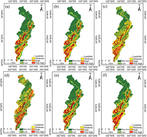
Furthermore, the LSM () predicted by the SAE-RF method displays a chaotic spatial pattern in which features overlap several landslide-related environmental factors. Similarly, the LSM results in Luding County also show the same spatial distribution pattern ().
Figure 8. Landslide susceptibility maps of the six models for luding county. (a) Proposed method; (b) TrAdaBoost-RF method; (c) SAE-RF method-based luding dataset; (d) SAE-RF method-based luding dataset and wenchuan dataset; (e) RF method-based luding dataset; and (f) RF method-based luding dataset and wenchuan dataset.
Accordingly, this suggests that an unsupervised SAE method can not only effectively extract local characteristics among predisposing factors, but can also reduce dimensionality in the selection of predisposing factors.
4.3. Model comparison and validation
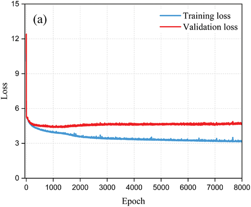
In , the training loss and validation loss of the SAE model are plotted against the number of iterations. The SAE model demonstrates high learning ability, as evidenced by the sharp decrease in both training and validation loss values, which stabilize at approximately 3 and 6, respectively, after 2000 iterations, while the training accuracy continues to increase. For all the statistical indices, the proposed method consistently achieves the highest values, with AUC, F1, kappa, precision, and recall values of 0.920, 0.850, 0.682, 0.821, and 0.886, respectively, for Lushan County and 0.972, 0.924, 0.845, 0.904, and 0.947, respectively, for Luding County. These results indicate that the proposed method outperforms other methods in terms of predictive accuracy and robustness. Furthermore, the AUC of the1TrAdaBoost-RF (0.909)-based transfer learning method is lower than that of the3RF method (0.915), which explains why valuable landslide samples should be screened in the source domain. In addition, although the number of the1RF and2RF datasets is larger than that of the3RF and4RF datasets, the AUC values of the1RF (0.890) and2RF (0.935) datasets are lower than those of the3RF (0.915) and4RF (0.966) datasets.
Figure 9. Loss values of the SAE model training process.
5. Discussion
5.1. Importance of feature representation
Effective feature representation among environmental factors is beneficial for exploring latent information in complex and heterogeneous environments (Huang et al. Citation2022a, Citation2022b; Wang et al. Citation2020; Zhao and Chen Citation2023; Zhao et al. Citation2021). In this study, we first calculated FRs and KL values for the three study areas, which show the obvious effect of each environmental factor on landslide occurrence () and contribute to solving the problem of feature dissimilarity. The differences in FR values hinder the process of transfer learning between source and target areas. The enhancement of knowledge representation among environmental factors can be achieved with the optimal discretization method and knowledge extraction (Huang et al. Citation2020a, Citation2024; Zhao and Chen Citation2023). Therefore, we introduced the SAE algorithm, which can effectively explore the linear and nonlinear correlations among input variables and extract natural and deep features from unlabeled data to avoid incorrect label assignment and reduce bias (Huang et al. Citation2020b; Zhang, Isola, and Efros Citation2017). For instance, a study investigated the performance of combining a sparse autoencoder and support vector machine, which provided better feature descriptions than the original data (Huang et al. Citation2020b). In contrast to previous studies, we only regard the output features of the SAE model as the input variables of environmental consistency rather than the final features (Huang et al. Citation2020b; Nam and Wang Citation2020). The results also show that the SAE-RF model can extract multidimensional characteristics of the environmental factors () and that the proposed method obtains the best AUC values (0.920 and 0.972) compared with traditional1TrAdaBoost-RF and2 TrAdaBoost-RF. Therefore, well-characterized features learned from original data can be used and provide insights into environmental similarity constraints. This can explain why the feature representation is considered in this study.
5.2. Importance of environmental consistency
The essential contribution of this study is that we propose a methodology for exploring feature representations and filtering similar data based on environmental consistency constraints. In this study, we successfully achieved knowledge transfer and extracted 2,130 and 120 useful samples from the Wenchuan dataset. The experimental results show that the AUC values of1RF and2 RF (0.890 and 0.935, respectively) are not improved by directly combining samples from the two study areas; instead, the proposed method has better performance than other methods. Thus, it is necessary to eliminate interfering samples by considering environmental consistency before knowledge sharing for different target areas. This is why we considered the SAE model and added environment-related similarity indices to the ESC to improve the interpretability of the proposed method. Although many studies have considered various unsupervised methods in LSP (Huang et al. Citation2020b; Nam and Wang Citation2020), a mathematical procedure based on ESC for filtering effective samples in the source domain has not been considered. Previous studies have developed only environmental similarity calculations that derive the best performance susceptibility results (Wang, Goetz, and Brenning Citation2022; Zhao et al. Citation2021, Citation2023b; Zhu et al. Citation2020). This study proposes filtering useful landslide samples in the source domain, which explains when, where and how knowledge in the source area transfers to the target area with limited data. In addition, environmental consistency or dissimilarity is a critical factor for model transferability (Wang, Goetz, and Brenning Citation2022; Zeng et al. Citation2022). The introduction of ESC may be able to handle negative transfer via overall environmental similarity calculations, suggesting the suitability of samples adopted in different study areas (Yates et al. Citation2018).
5.3. Future research
There are some potential improvements that can be considered in future work regarding transfer learning analysis.
First, more feature-related or process-related indices can be considered in the selection of similarity samples. The essential attributes among landslide-predisposing factors cannot describe complex and heterogeneous geographic environments (Masrur et al. Citation2022; Wang et al. Citation2020; Zhao et al. Citation2023b), and we recommend the extraction of more spatial features to help differentiate useful samples.
Second, we assumed that all landslide-related environmental factors in the source and target domains were identical. However, the physical processes of landslides in different areas are different, and we cannot guarantee that the same factor has a uniform effect on the spatial prediction of landslides. Accordingly, a suitable landslide-related environmental factor should be implemented in model transfer rather than all variables considered for use in the transfer process (Liang, Qin, and Zhu Citation2021). In other words, a more likely transferable approach should focus on the selection of features, as well as individual variables.
Third, relationship-based transfer, which is a type of physical landslide process, can be considered in the LSP. Therefore, landslide spatial prediction utilizing multiple landslide inventories is promising.
6. Conclusions
This study proposes and assesses a heterogeneous transfer learning method considering feature representation and environmental consistency to improve the robustness and transferability of spatial landslide predictions. The proposed method trains a stacked autoencoder to extract more representation features in an unsupervised manner, and then an environmental similarity criterion is implemented to filter valuable landslide inventories in the source area. Previous studies have not differentiated transferable landslide data and have directly adopted all data in the process of transfer learning. An extensive case study shows that the proposed method has better robustness and transferability than the other three methods. First, a stacked autoencoder can effectively extract latent knowledge from the source domain. Second, the introduction of the environmental similarity criterion filters the useful landslide samples in the source domain to avoid negative transfer learning. As a result, the proposed method can not only be applied to emergency rescue and disaster prevention but can also provide a promising way to improve landslide predictions of models in incomplete landslide inventories. Future work can be dedicated to advancing this transferring approach by considering more suitable relationship-related transfer learning methods and covering more transferable landslide datasets for different areas.
Data and code availability statement
The experimental data and the software source codes can be obtained at https://github.com/millet5818/TL_LSM.
Highlights
A heterogeneous transfer learning method considering feature representation and environmental consistency is proposed.
A stacked autoencoder can effectively extract latent knowledge from the source domain.
The environmental similarity criterion filters the valuable samples to avoid negative transfer learning.
The proposed transfer learning contributes to improving the performance of landslide spatial prediction.
tgrs_a_2349343_sm0347.docx
Download MS Word (15.3 KB)tgrs_a_2349343_sm0346.pdf
Download PDF (1.8 MB)Acknowledgments
We thank the Lushan Natural Resources and Planning Bureau, Lushan Public Security Bureau, Lushan Transportation Bureau, Ya’an Public Meteorological Service Center, Sichuan Institute of Geological Survey, China Earthquake Network Center, Geospatial Data Cloud Website, United States Geological Survey, and European Space Agency for providing the data needed for the experiments. In addition, we thank Mr. Yulong Qin for his warm support during the experiments. This study was supported by the Project of Sichuan Science and Technology Program [Grant No. 2019YFG0187]. The authors are grateful to the editor of the journal and the anonymous reviewers for their valuable comments and recommendations.
Disclosure statement
No potential conflict of interest was reported by the author(s).
Additional information
Funding
References
- Abbaszadeh Shahri, A., J. Spross, F. Johansson, and S. Larsson. 2019. “Landslide Susceptibility Hazard Map in Southwest Sweden Using Artificial Neural Network.” Catena 183:104225. https://doi.org/10.1016/j.catena.2019.104225.
- Ai, X., B. Sun, and X. Chen. 2022. “Construction of Small Sample Seismic Landslide Susceptibility Evaluation Model Based on Transfer Learning: A Case Study of Jiuzhaigou Earthquake.” Bulletin of Engineering Geology and the Environment 81 (3): 116. https://doi.org/10.1007/s10064-022-02601-6.
- Al-Najjar, H. A. H., B. Pradhan, B. Kalantar, M. I. Sameen, M. Santosh, and A. Alamri. 2021. “Landslide Susceptibility Modeling: An Integrated Novel Method Based on Machine Learning Feature Transformation.” Remote Sensing 13 (16): 3281. https://doi.org/10.3390/rs13163281.
- Ba, Q., Y. Chen, S. Deng, J. Yang, and H. Li. 2018. “A Comparison of Slope Units and Grid Cells as Mapping Units for Landslide Susceptibility Assessment.” Earth Science Informatics 11 (3): 373–22. https://doi.org/10.1007/s12145-018-0335-9.
- Bhuyan, K., S. R. Meena, L. Nava, C. van Westen, M. Floris, and F. Catani. 2023. “Mapping Landslides Through a Temporal Lens: An Insight Toward Multi-Temporal Landslide Mapping Using the U-Net Deep Learning Model.” GIScience & Remote Sensing 60 (1): 2182057. https://doi.org/10.1080/15481603.2023.2182057.
- Chang, Z., Z. Du, F. Zhang, F. Huang, J. Chen, W. Li, and Z. Guo. 2020. “Landslide Susceptibility Prediction Based on Remote Sensing Images and GIS: Comparisons of Supervised and Unsupervised Machine Learning Models.” Remote Sensing 12 (3): 502. https://doi.org/10.3390/rs12030502.
- Charte, D., F. Charte, S. García, M. J. Del Jesus, and F. Herrera. 2018. “A Practical Tutorial on Autoencoders for Nonlinear Feature Fusion: Taxonomy, Models, Software and Guidelines.” Information Fusion 44:78–96. https://doi.org/10.1016/j.inffus.2017.12.007.
- Chen, L., Y. Ding, S. Pirasteh, H. Hu, Q. Zhu, X. Ge, H. Zeng, H. Yu, Q. Shang, and Y. Song. 2022. “Meta-Learning an Intermediate Representation for Few-Shot Prediction of Landslide Susceptibility in Large Areas.” International Journal of Applied Earth Observation and Geoinformation 110:102807. https://doi.org/10.1016/j.jag.2022.102807.
- Chen, S., Z. Miao, L. Wu, and Y. He. 2020. “Application of an Incomplete Landslide Inventory and One Class Classifier to Earthquake-Induced Landslide Susceptibility Mapping.” IEEE Journal of Selected Topics in Applied Earth Observations and Remote Sensing 13:1649–1660. https://doi.org/10.1109/JSTARS.2020.2985088.
- Chen, W., H. R. Pourghasemi, A. Kornejady, and N. Zhang. 2017. “Landslide Spatial Modeling: Introducing New Ensembles of ANN, MaxEnt, and SVM Machine Learning Techniques.” Geoderma 305:314–327. https://doi.org/10.1016/j.geoderma.2017.06.020.
- Chen, J., K. Xu, Z. Zhao, X. Gan, and H. Xie. 2024. “A Cellular Automaton Integrating Spatial Case-Based Reasoning for Predicting Local Landslide Hazards.” International Journal of Geographical Information Science 38 (1): 100–127. https://doi.org/10.1080/13658816.2023.2273877.
- Chowdhuri, I., S. C. Pal, A. Arabameri, P. T. T. Ngo, R. Chakrabortty, S. Malik, B. Das, and P. Roy. 2020. “Ensemble Approach to Develop Landslide Susceptibility Map in Landslide Dominated Sikkim Himalayan Region, India.” Environmental Earth Sciences 79 (20): 1–28. https://doi.org/10.1007/s12665-020-09227-5.
- Chowdhuri, I., S. C. Pal, R. Chakrabortty, S. Malik, B. Das, and P. Roy. 2021. “Torrential Rainfall-Induced Landslide Susceptibility Assessment Using Machine Learning and Statistical Methods of Eastern Himalaya.” Natural Hazards 107 (1): 697–722. https://doi.org/10.1007/s11069-021-04601-3.
- Chowdhuri, I., S. C. Pal, S. Janizadeh, A. Saha, K. Ahmadi, R. Chakrabortty, A. R. M. Towfiqul Islam, P. Roy, and M. Shit. 2022. “Application of Novel Deep Boosting Framework-Based Earthquake Induced Landslide Hazards Prediction Approach in Sikkim Himalaya.” Geocarto International 37 (26): 12509–12535. https://doi.org/10.1080/10106049.2022.2068675.
- Conoscenti, C., E. Rotigliano, M. Cama, N. A. Caraballo-Arias, L. Lombardo, and V. Agnesi. 2016. “Exploring the Effect of Absence Selection on Landslide Susceptibility Models: A Case Study in Sicily, Italy.” Geomorphology 261:222–235. https://doi.org/10.1016/j.geomorph.2016.03.006.
- Corominas, J., C. van Westen, P. Frattini, L. Cascini, J. P. Malet, S. Fotopoulou, and J. T. Smith. 2014. “Recommendations for the Quantitative Analysis of Landslide Risk.” Bulletin of Engineering Geology and the Environment 73:209–263. https://doi.org/10.1007/s10064-013-0538-8.
- Cui, S., X. Pei, Y. Jiang, G. Wang, X. Fan, Q. Yang, and R. Huang. 2021. “Liquefaction within a Bedding Fault: Understanding the Initiation and Movement of the Daguangbao Landslide Triggered by the 2008 Wenchuan Earthquake (Ms = 8.0).” Engineering Geology 295:106455. https://doi.org/10.1016/j.enggeo.2021.106455.
- Dai, K., J. Deng, Q. Xu, Z. Li, X. Shi, C. Hancock, N. Wen, L. Zhang, and G. Zhuo. 2022. “Interpretation and Sensitivity Analysis of the InSAR Line of Sight Displacements in Landslide Measurements.” GIScience & Remote Sensing 59 (1): 1226–1242. https://doi.org/10.1080/15481603.2022.2100054.
- Dai, W., Q. Yang, G. R. Xue, and Y. Yu 2007. Boosting for Transfer Learning. In: Proceedings of the 24th international conference on Machine learning - ICML ’07. ACM Press, Corvalis, Oregon, pp. 193–200.
- Froude, M. J., and D. N. Petley. 2018. “Global Fatal Landslide Occurrence from 2004 to 2016.” Natural Hazards and Earth System Sciences 18 (8): 2161–2181. https://doi.org/10.5194/nhess-18-2161-2018.
- Gariano, S. L., and F. Guzzetti. 2016. “Landslides in a Changing Climate.” Earth-Science Reviews 162:227–252. https://doi.org/10.1016/j.earscirev.2016.08.011.
- He, Y., Z. A. Zhao, W. Yang, H. Yan, W. Wang, S. Yao, L. Zhang, and T. Liu. 2021. “A Unified Network of Information Considering Superimposed Landslide Factors Sequence and Pixel Spatial Neighbourhood for Landslide Susceptibility Mapping.” International Journal of Applied Earth Observation and Geoinformation 104:102508. https://doi.org/10.1016/j.jag.2021.102508.
- Hinton, G. E., and R. R. Salakhutdinov. 2006. “Reducing the Dimensionality of Data with Neural Networks.” Science 313 (5786): 504–507. https://doi.org/10.1126/science.1127647.
- Hong, H., Y. Miao, J. Liu, and A. X. Zhu. 2019. “Exploring the Effects of the Design and Quantity of Absence Data on the Performance of Random Forest-Based Landslide Susceptibility Mapping.” Catena 176:45–64. https://doi.org/10.1016/j.catena.2018.12.035.
- Huang, F., Z. Cao, J. Guo, S. H. Jiang, S. Li, and Z. Guo. 2020a. “Comparisons of Heuristic, General Statistical and Machine Learning Models for Landslide Susceptibility Prediction and Mapping.” Catena 191:104580. https://doi.org/10.1016/j.catena.2020.104580.
- Huang, F., S. Tao, D. Li, Z. Lian, F. Catani, J. Huang, K. Li, and C. Zhang. 2022a. “Landslide Susceptibility Prediction Considering Neighborhood Characteristics of Landslide Spatial Datasets and Hydrological Slope Units Using Remote Sensing and GIS Technologies.” Remote Sensing 14 (18): 4436. https://doi.org/10.3390/rs14184436.
- Huang, F., Z. Teng, C. Yao, S. H. Jiang, F. Catani, W. Chen, and J. Huang. 2024. “Uncertainties of Landslide Susceptibility Prediction: Influences of Random Errors in Landslide Conditioning Factors and Errors Reduction by Low Pass Filter Method.” Journal of Rock Mechanics and Geotechnical Engineering 16 (1): 213–230. https://doi.org/10.1016/j.jrmge.2023.11.001.
- Huang, F., J. Yan, X. Fan, C. Yao, J. Huang, W. Chen, and H. Hong. 2022b. “Uncertainty Pattern in Landslide Susceptibility Prediction Modelling: Effects of Different Landslide Boundaries and Spatial Shape Expressions.” Geoscience Frontiers 13 (2): 101317. https://doi.org/10.1016/j.gsf.2021.101317.
- Huang, F., J. Zhang, C. Zhou, Y. Wang, J. Huang, and L. Zhu. 2020b. “A Deep Learning Algorithm Using a Fully Connected Sparse Autoencoder Neural Network for Landslide Susceptibility Prediction.” Landslides 17 (1): 217–229. https://doi.org/10.1007/s10346-019-01274-9.
- Jia, G., M. Alvioli, S. L. Gariano, I. Marchesini, F. Guzzetti, and Q. Tang. 2021. “A Global Landslide Non-Susceptibility Map.” Geomorphology 389:107804. https://doi.org/10.1016/j.geomorph.2021.107804.
- Jiang, J., and C. Zhai 2007. Instance Weighting for Domain Adaptation in NLP. In: Proceedings of the 45th Annual Meeting of the Association Computational Linguistics, 23–30 June, Prague, Czech Republic, pp. 264–271.
- Kullback, S., and R. A. Leibler. 1965. “On Information and Sufficiency.” The Annals of Mathematical Statistics 22 (1): 79–86. https://doi.org/10.1214/aoms/1177729694.
- Lee, S., J.-H. Ryu, and I.-S. Kim. 2007. “Landslide Susceptibility Analysis and Its Verification Using Likelihood Ratio, Logistic Regression, and Artificial Neural Network Models: Case Study of Youngin, Korea.” Landslides 4 (4): 327–338. https://doi.org/10.1007/s10346-007-0088-x.
- Liang, P., C. Z. Qin, and A. X. Zhu. 2021. “Comparison on Two Case-Based Reasoning Strategies of Automatically Selecting Terrain Covariates for Digital Soil Mapping.” Transactions in GIS 25 (5): 2419–2437. https://doi.org/10.1111/tgis.12831.
- Lin, Q., P. Lima, S. Steger, T. Glade, T. Jiang, J. Zhang, T. Liu, and Y. Wang. 2021. “National-Scale Data-Driven Rainfall Induced Landslide Susceptibility Mapping for China by Accounting for Incomplete Landslide Data.” Geoscience Frontiers 12 (6): 101248. https://doi.org/10.1016/j.gsf.2021.101248.
- Masrur, A., M. Yu, P. Mitra, D. Peuquet, and A. Taylor. 2022. “Interpretable Machine Learning for Analysing Heterogeneous Drivers of Geographic Events in Space-Time.” International Journal of Geographical Information Science 36 (4): 692–719. https://doi.org/10.1080/13658816.2021.1965608.
- Moragues, S., M. G. Lenzano, M. Lanfri, S. Moreiras, E. Lannutti, and L. Lenzano. 2021. “Analytic Hierarchy Process Applied to Landslide Susceptibility Mapping of the North Branch of Argentino Lake, Argentina.” Natural Hazards 105 (1): 915–941. https://doi.org/10.1007/s11069-020-04343-8.
- Nam, K., and F. Wang. 2020. “An Extreme Rainfall-Induced Landslide Susceptibility Assessment Using Autoencoder Combined with Random Forest in Shimane Prefecture, Japan.” Geoenvironmental Disasters 7 (1): 1–16. https://doi.org/10.1186/s40677-020-0143-7.
- Ouyang, S., W. Chen, H. Liu, Y. Li, and Z. Xu. 2024. “A Novel Landslide Susceptibility Prediction Framework Based on Contrastive Loss.” GIScience & Remote Sensing 61 (1): 2306740. https://doi.org/10.1080/15481603.2024.2306740.
- Pal, S. C., R. Chakrabortty, A. Saha, S. K. Bozchaloei, Q. B. Pham, N. T. T. Linh, D. T. Anh, S. Janizadeh, and K. Ahmadi. 2022. “Evaluation of Debris Flow and Landslide Hazards Using Ensemble Framework of Bayesian-And Tree-Based Models.” Bulletin of Engineering Geology and the Environment 81 (1): 1–25. https://doi.org/10.1007/s10064-021-02546-2.
- Pal, S. C., and I. Chowdhuri. 2019. “GIS-Based Spatial Prediction of Landslide Susceptibility Using Frequency Ratio Model of Lachung River Basin, North Sikkim, India.” SN Applied Sciences 1 (5): 1–25. https://doi.org/10.1007/s42452-019-0422-7.
- Pal, S. C., B. Das, and S. Malik. 2019. “Potential Landslide Vulnerability Zonation Using Integrated Analytic Hierarchy Process and GIS Technique of Upper Rangit Catchment Area, West Sikkim, India.” Journal of the Indian Society of Remote Sensing 47 (10): 1643–1655. https://doi.org/10.1007/s12524-019-01009-2.
- Panahi, M., A. Jaafari, A. Shirzadi, H. Shahabi, O. Rahmati, E. Omidvar, S. Lee, and D. T. Bui. 2021. “Deep Learning Neural Networks for Spatially Explicit Prediction of Flash Flood Probability.” Geoscience Frontiers 12 (3): 101076. https://doi.org/10.1016/j.gsf.2020.09.007.
- Pan, S., and Q. Yang. 2010. “A Survey on Transfer Learning.” IEEE Transactions on Knowledge and Data Engineering 22 (10): 1345–1359. https://doi.org/10.1109/TKDE.2009.191.
- Park, J. Y., S. R. Lee, D. H. Lee, Y. T. Kim, and J. S. Lee. 2019. “A Regional-Scale Landslide Early Warning Methodology Applying Statistical and Physically Based Approaches in Sequence.” Engineering Geology 260:105193. https://doi.org/10.1016/j.enggeo.2019.105193.
- Pham, B. T., A. Jaafari, I. Prakash, and D. T. Bui. 2019a. “A Novel Hybrid Intelligent Model of Support Vector Machines and the MultiBoost Ensemble for Landslide Susceptibility Modeling.” Bulletin of Engineering Geology and the Environment 78 (4): 2865–2886. https://doi.org/10.1007/s10064-018-1281-y.
- Pham, B. T., and I. Prakash. 2019. “Evaluation and Comparison of LogitBoost Ensemble, fisher’s Linear Discriminant Analysis, Logistic Regression and Support Vector Machines Methods for Landslide Susceptibility Mapping.” Geocarto International 34 (3): 316–333. https://doi.org/10.1080/10106049.2017.1404141.
- Pham, B. T., I. Prakash, S. K. Singh, A. Shirzadi, H. Shahabi, and D. T. Bui. 2019b. “Landslide Susceptibility Modeling Using Reduced Error Pruning Trees and Different Ensemble Techniques: Hybrid Machine Learning Approaches.” Catena 175:203–218. https://doi.org/10.1016/j.catena.2018.12.018.
- Qi, S., Q. Xu, H. Lan, B. Zhang, and J. Liu. 2010. “Spatial Distribution Analysis of Landslides Triggered by 2008.5.12 Wenchuan Earthquake, China.” Engineering Geology 116 (1–2): 95–108. https://doi.org/10.1016/j.enggeo.2010.07.011.
- Reichenbach, P., M. Rossi, B. D. Malamud, M. Mihir, and F. Guzzetti. 2018. “A Review of Statistically-Based Landslide Susceptibility Models.” Earth-Science Reviews 180:60–91. https://doi.org/10.1016/j.earscirev.2018.03.001.
- Ruidas, D., R. Chakrabortty, A. R. M. T. Islam, A. Saha, and S. C. Pal. 2022. “A Novel Hybrid of Meta-Optimization Approach for Flash Flood-Susceptibility Assessment in a Monsoon-Dominated Watershed, Eastern India.” Environmental Earth Sciences 81 (5): 145. https://doi.org/10.1007/s12665-022-10269-0.
- Ruidas, D., S. C. Pal, A. R. M. T. Islam, and A. Saha. 2021. “Characterization of Groundwater Potential Zones in Water-Scarce Hardrock Regions Using Data Driven Model.” Environmental Earth Sciences 80 (24): 1–18. https://doi.org/10.1007/s12665-021-10116-8.
- Ruidas, D., A. Saha, A. R. M. T. Islam, R. Costache, and S. C. Pal. 2023. “Development of Geo-Environmental Factors Controlled Flash Flood Hazard Map for Emergency Relief Operation in Complex Hydro-Geomorphic Environment of Tropical River, India.” Environmental Science and Pollution Research 30 (49): 106951–106966. https://doi.org/10.1007/s11356-022-23441-7.
- Seneviratne, S. I., N. Nicholls, D. Easterling, C. M. Goodess, S. Kanae, J. Kossin, and Y. Luo. 2012. “Changes in Climate Extremes and Their Impacts on the Natural Physical Environment.” In Managing the Risks of Extreme Events and Disasters to Advance Climate Change Adaptation: Special Report of the Intergovernmental Panel on Climate Change, edited by C. B. Field, V. Barros, T. F. Stocker, D. Qin, D. J. Dokken, K. L. Ebi, M. D. Mastrandrea, K. J. Mach, G.-K. Plattner, S. K. Allen, M. Tignor, 109–230, Cambridge, UK: Cambridge University Press.
- Steger, S., A. Brenning, R. Bell, and T. Glade. 2017. “The Influence of Systematically Incomplete Shallow Landslide Inventories on Statistical Susceptibility Models and Suggestions for Improvements.” Landslides 14 (5): 1767–1781. https://doi.org/10.1007/s10346-017-0820-0.
- Sun, D., H. Wen, D. Wang, and J. Xu. 2020. “A Random Forest Model of Landslide Susceptibility Mapping Based on Hyperparameter Optimization Using Bayes Algorithm.” Geomorphology 362:107201. https://doi.org/10.1016/j.geomorph.2020.107201.
- Vakhshoori, V., and M. Zare. 2016. “Landslide Susceptibility Mapping by Comparing Weight of Evidence, Fuzzy Logic, and Frequency Ratio Methods.” Geomatics, Natural Hazards and Risk 7 (5): 1731–1752. https://doi.org/10.1080/19475705.2016.1144655.
- Van Den Eeckhaut, M., J. Hervás, C. Jaedicke, J. P. Malet, L. Montanarella, and F. Nadim. 2011. “Statistical Modelling of Europe-Wide Landslide Susceptibility Using Limited Landslide Inventory Data.” Landslides 9 (3): 357–369. https://doi.org/10.1007/s10346-011-0299-z.
- Wang, Y., L. Feng, S. Li, F. Ren, and Q. Du. 2020. “A Hybrid Model Considering Spatial Heterogeneity for Landslide Susceptibility Mapping in Zhejiang Province, China.” Catena 188:104425. https://doi.org/10.1016/j.catena.2019.104425.
- Wang, Z., J. Goetz, and A. Brenning. 2022. “Transfer Learning for Landslide Susceptibility Modeling Using Domain Adaptation and Case-Based Reasoning.” Geoscientific Model Development 15 (23): 8765–8784. https://doi.org/10.5194/gmd-15-8765-2022.
- Wang, X., S. Li, H. Liu, L. Liu, Y. Liu, S. Zeng, and Q. Tang. 2021. “Landslide Susceptibility Assessment in Wenchuan County After the 5.12 Magnitude Earthquake.” Bulletin of Engineering Geology and the Environment 80 (7): 5369–5390. https://doi.org/10.1007/s10064-021-02280-9.
- Wang, C., Q. Lin, L. Wang, T. Jiang, B. Su, Y. Wang, S. K. Mondal, J. Huang, and Y. Wang. 2022. “The Influences of the Spatial Extent Selection for Non-Landslide Samples on Statistical-Based Landslide Susceptibility Modelling: A Case Study of Anhui Province in China.” Natural Hazards 112 (3): 1967–1988. https://doi.org/10.1007/s11069-022-05252-8.
- Wang, H., L. Wang, and L. Zhang. 2022. “Transfer Learning Improves Landslide Susceptibility Assessment.” Gondwana Research 123:238–254. https://doi.org/10.1016/j.gr.2022.07.008.
- Xu, Q., C. Ouyang, T. Jiang, X. Yuan, X. Fan, and D. Cheng. 2022. “MFFENet and ADANet: A Robust Deep Transfer Learning Method and Its Application in High Precision and Fast Cross-Scene Recognition of Earthquake-Induced Landslides.” Landslides 19 (7): 1617–1647. https://doi.org/10.1007/s10346-022-01847-1.
- Yao, J., X. Yao, Y. Wang, Z. Zhao, and X. Liu. 2024. “Current Active Fault Distribution and Slip Rate Along the Middle Section of the Jiali-Chayu Fault from Sentinel-1 InSAR Observations (2017–2022).” Earth, Planets and Space 76 (1): 21. https://doi.org/10.1186/s40623-024-01962-4.
- Yao, J., X. Yao, Z. Zhao, and X. Liu. 2023. “Performance Comparison of Landslide Susceptibility Mapping Under Multiple Machine-Learning Based Models Considering InSAR Deformation: A Case Study of the Upper Jinsha River.” Geomatics, Natural Hazards and Risk 14 (1): 2212833. https://doi.org/10.1080/19475705.2023.2212833.
- Yates, K. L., P. J. Bouchet, M. J. Caley, K. Mengersen, C. F. Randin, S. Parnell, A. H. Fielding, et al. 2018. “Outstanding Challenges in the Transferability of Ecological Models.” Trends in Ecology & Evolution 33 (10): 790–802. https://doi.org/10.1016/j.tree.2018.08.001.
- Youssef, A. M., H. R. Pourghasemi, Z. S. Pourtaghi, and M. M. Al-Katheeri. 2015. “Landslide Susceptibility Mapping Using Random Forest, Boosted Regression Tree, Classification and Regression Tree, and General Linear Models and Comparison of Their Performance at Wadi Tayyah Basin, Asir Region, Saudi Arabia.” Landslides 13 (5): 839–856. https://doi.org/10.1007/s10346-015-0614-1.
- Zeng, H., Q. Zhu, Y. Ding, H. Hu, L. Chen, X. Xie, M. Chen, and Y. Yao. 2022. “Graph Neural Networks with Constraints of Environmental Consistency for Landslide Susceptibility Evaluation.” International Journal of Geographical Information Science 36 (11): 2270–2295. https://doi.org/10.1080/13658816.2022.2103819.
- Zhang, S., L. Bai, Y. Li, W. Li, and M. Xie. 2022. “Comparing Convolutional Neural Network and Machine Learning Models in Landslide Susceptibility Mapping: A Case Study in Wenchuan County.” Frontiers in Environmental Science 496. https://doi.org/10.3389/fenvs.2022.886841.
- Zhang, R., P. Isola, and A. A. Efros. 2017. “Split-Brain Autoencoders: Unsupervised Learning by Cross-Channel Prediction.” In Proceedings of the IEEE conference on computer vision and pattern recognition, Honolulu, Hawaii, USA, 1058–1067.
- Zhao, Z., and J. Chen. 2023. “A Robust Discretization Method of Factor Screening for Landslide Susceptibility Mapping Using Convolution Neural Network, Random Forest, and Logistic Regression Models.” International Journal of Digital Earth 16 (1): 408–429. https://doi.org/10.1080/17538947.2023.2174192.
- Zhao, Z., J. Chen, K. Xu, H. Xie, X. Gan, and H. Xu. 2021. “A Spatial Case-Based Reasoning Method for Regional Landslide Risk Assessment.” International Journal of Applied Earth Observation and Geoinformation 102:102381. https://doi.org/10.1016/j.jag.2021.102381.
- Zhao, Z., J. Chen, J. Yao, K. Xu, Y. Liao, H. Xie, and X. Gan. 2023b. “An Improved Spatial Case-Based Reasoning Considering Multiple Spatial Drivers of Geographic Events and Its Application in Landslide Susceptibility Mapping.” Catena 223:106940. https://doi.org/10.1016/j.catena.2023.106940.
- Zhao, C., L. Chen, Y. Yin, X. Liu, B. Li, C. Ren, and D. Liu. 2023a. “Failure Process and Three-Dimensional Motions of Mining-Induced Jianshanying Landslide in China Observed by Optical, LiDAR and SAR Datasets.” GIScience & Remote Sensing 60 (1): 2268367. https://doi.org/10.1080/15481603.2023.2268367.
- Zhu, Q., L. Chen, H. Hu, S. Pirasteh, H. Li, and X. Xie. 2020. “Unsupervised Feature Learning to Improve Transferability of Landslide Susceptibility Representations.” IEEE Journal of Selected Topics in Applied Earth Observations and Remote Sensing 13:3917–3930. https://doi.org/10.1109/JSTARS.2020.3006192.
- Zhu, L., G. Wang, F. Huang, Y. Li, W. Chen, and H. Hong. 2022. “Landslide Susceptibility Prediction Using Sparse Feature Extraction and Machine Learning Models Based on GIS and Remote Sensing.” IEEE Geoscience and Remote Sensing Letters 19:1–5. https://doi.org/10.1109/LGRS.2021.3054029.