
ABSTRACT
Along the northern littoral of the Iberian Peninsula, from Cuerres (Asturias) to Oyambre (Cantabria) there are caves, such as El Pindal (World Heritage List). Two geomorphologic maps have been prepared: a general scaled 1:25000, and a detail one of the cave, with erosional and depositional landforms geomorphologic units. A relative Quaternary chronology for the depositional landforms, uses colour spots. Marine morphologies suitable for determining past sea-level positions were surveyed to identify the elevation of past high-stands and reconstructing paleo-shorelines. As a result, the study of seven erosional surfaces (rasas) in quartzites and six on limestones led to reconstructing a general sequence between 275–120 m and 90–1 m above sea level (a.s.l.) respectively. Around the El Pindal cave there are four rasas cut on quartzites (171–160 m) and four cut on limestone (65–32 m). Other additional indicators of paleoshorelines are: 24–25 m entrance to the El Pindal cave, 20–21 m lower Pindal, 15–17 m marine terrace, 9–10 m shelter, 2–3 m notches and 0–1 m present rasa.Considering the elevation rates for the various rasas, an estimated value of 0.066 mm/y as the most probable, it is concluded that the beginning of Quaternary lays at 172 m a.s.l.
1. Introduction
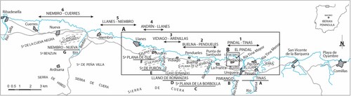
The selected study area includes two zones: an ample one, between Nueva (Llanes) and the Nansa river mouth (Ría de Tina Menor) and a smaller one near El Pindal Cave which extends from the littoral between Rejolguero and Moral bays to Pimiango ().
Figure 1. Study area.
This paper presents a geomorphological map based upon previous photo-geologic survey with field controls, map elaboration and later GIS digitalization and geo-referentiation. The study includes a detailed analysis of previous sea-level positions and the genesis of erosional and depositional marine terraces.
There are many studies of erosional marine terraces (rasas) since the middle twentieth Century. Some of the most outstanding are: CitationGómez de Llarena and Royo Gómez (Citation1927), CitationHernández Pacheco (Citation1956, Citation1957), CitationHernández Pacheco et al. (Citation1957), CitationLlopis Lladó (Citation1962), CitationHernandez Pacheco and Asensio Amor (Citation1963, Citation1964), CitationMary (Citation1970, Citation1971, Citation1985, Citation1977, Citation1983), CitationGuilcher (Citation1974), CitationFlor (Citation1983), CitationDuque and Elizaga (Citation1983), CitationHoyos Gomez (Citation1987, Citation1989), CitationMoñino et al. (Citation1988), CitationGarzón et al. (Citation1996), CitationGonzález et al. (Citation2005), CitationJiménez-Sánchez et al. (Citation2006), CitationGutiérrez Claverol et al. (Citation2006), CitationÁlvarez-Marrón et al. (Citation2008), CitationFlor and Flor-Blanco (Citation2009, Citation2014a, Citation2014b), CitationMoreno et al. (Citation2009), CitationDomínguez-Cuesta et al. (Citation2013, Citation2015), CitationPedoja et al. (Citation2011, Citation2014, Citation2018), CitationAdrados (Citation2014), CitationLópez-Fernández et al. (Citation2020), CitationRemondo (Citation2020). Most of these papers refer to the rasas of the Cantabrian littoral without offering either a clear chronology or the Quaternary evolution. Only CitationÁlvarez-Marrón et al. (Citation2008) gave a numerical age for the rasa of Cabo Peñas based on cosmogenic isotopes, and CitationPedoja et al. (Citation2014, Citation2018), who compare these rasas with others in Europe, providing ages for marine deposits. More recently, CitationSanz de Murieta et al. (Citation2021) gave an age of ca. 130 Ka based on quartz and feldspar luminescence (OSL), for the deposit of a Last Interglacial marine terrace in Oyambre Beach (Cantabria).
Concerning El Pindal Cave, some papers (such as CitationBallesteros et al., Citation2019; CitationJiménez-Sánchez et al., Citation2002, Citation2004, Citation2006) calculated a minimum age of the cave based on phreatic speleothems.
The aim of this paper is to present a geomorphological map that allows interpreting landforms of karstic systems for reconstructing the successive sea-level changes during Quaternary and to determine the age of El Pindal Cave, to calculate rates of regional uplift of this area and to locate the limit of the Quaternary in the general sequence of rasas, correlating marine and karstic sequences in the two study areas. This is based on the study of the geomorphological evolution of marine sequences and markers of sea-level highstands on karstified carbonate rocks.
2. Geological-geomorphological setting
The Eastern Asturian coastal belt, from Cuerres to the Ría of Tina Menor (Cantabria), is a part of a geomorphological unit adjacent to the Hibea and Cuera ranges, which consists of a system of intermediate less elevated ranges (Purón range, Cué and La Borbolla Plains), and extends to the littoral where the reliefs are flat surfaces. Pre-Permian rocks dominate in this area, with some unconformable, small outcrops of Cretaceous rocks (to the West and East of Punta de Santiuste) forming a fringe between La Franca and south of Pimiango and eastwards of Tina Menor (Santa Catalina), just overlying the eastern limit of the karstified Late Carboniferous limestones. The width of the karstified littoral belt ranges from 4 km (Llanes) to 1 km (El Pindal).
From a geological point of view, this is a part of the Eastern Cantabrian Zone where Late Carboniferous carbonate rocks abound. These are parallel-laminated dark/blackish rocks and sedimentary breccias (Barcaliente Formation) of Namurian-Westphalian age, and Westphalian light-coloured (white-beige) limestones (CitationGarcía-Ramos & Gutiérrez Claverol, Citation1995).
The substratum includes the Lower Ordovician quartzites, paraconglomerates and sandstones with interbedded mudstones of the Barrios Formation, which form NE-SW oriented, roughly parallel to the coast and referred to as flat sierras, plains and rasas, located in this area at elevations between 125 and 275 m. These occur staircased, and gently inclined towards the sea (CitationNavarro & Leyva, Citation1996, CitationPortero et al., Citation1976).
The complex regional structure is the result of a superposition of the Variscan orogeny, a phase of extensional tectonics that generated the Mesozoic basins and the later Alpine orogeny. The Alpine deformation uplifted the basement and reactivated old Variscan structures (CitationAlonso & Pulgar, Citation1995). The alpine fractures were later reactivated by recent (Pliocene-Quaternary) neotectonics, as suggested by various geomorphologic indicators. There are in the area several post-alpine small-scale displacements with directions E-W and WNW-ESE.
3. Methods
The most relevant morphologies have been marked in the geomorphologic map (, main map).
From a lithological and structural analysis of the materials of the geological substrate that the cartography covers; For this, a simplified geological map (Geology Map) is introduced in the general map, in order to be able to differentiate the two types of substrate: (1) highly permeable, intensely dissolved, dolomitic limestones and breccias, prone to karstification, and (2) low-permeability quartzite, paraconglomerates and sandstones prone to the superficial movement of water with limited infiltration. Given the difficulty in using conventional geological plots to represent the substratum (it darkens the map), it has been preferred to make the additional geological scheme indicated above and represent the geomorphological units on a DEM that allows a better vision of the 3D relief. On this basis, the geomorphological units of erosion and deposit (surface formations) have been represented, to which we have given a textural pattern and a relative age by assigning a colour for the Lower Pleistocene (purple), Middle Pleistocene (green), Upper Pleistocene (blue) and Holocene (red).
Characteristic (erosional, depositional) forms. These are represented and arranged according to their genetic groups: marine, karstic, fluvial, gravitational, polygenic, and morpho-structural. Particular attention was paid to marine (rasas, cliffs, caves and shelters, etc.) and karstic (dolines, cenotes or vertical caves, poljes or interior valleys, canyons, lapiazes or karren, etc.) morphologies. All these are represented by standard geomorphologic symbols superimposed on the colour corresponding to their genesis. This allows a rapid, easy visualization also assessing the importance of each morphogenetic system.
The most significant morphologic units are marine forms and deposits, and karstic features. Based on these it is possible to deduce sea-level highstands and also the various base levels of the systems of caves and galleries associated to them.
The elevations of these morphologic features related to the present sea level were used to construct a staircased sequence of Quaternary morphologies and/or deposits. Elevations are measured at the transgressive maxima of the forms and marine deposits (type and sedimentary structures), caves, shelters and notches related to the high tide mark of present beaches. Each morphologic reference recognized represents the general water table (sea level) at the time of formation, and can be related to the caves, conducts and galleries of the littoral karstic systems (endokarst), that occur at different elevations as a consequence of the general uplift of the emergent land (littoral and pre-littoral) owing to epirogenetic movements.
4. Results
The map allows a better knowledge of the geological-geomorphological parameters that affect the El Pindal karstic system indicating the type of limestone lithology, degree of solubility, the structures affecting them (faults, joints and dips), ways of dissolution (lapiazes, dolines and poljes), and possible hydric inputs through creeks, the Quaternary deposits associated to these depressions and the slopes of the mountain front (alluvial cones and colluvium), owing to the influence of depressions as potential collectors of runoff water.
General area (Cuerres-Tina Menor). Presented a geomorphological mapping of the area between Llanes and the Nansa river mouth (Tina Menor) marking the erosional marine terraces (rasas) over quarzitic and carbonate rocks. The distribution of morphogenetic systems, morphotectonic behaviours and paleogeographical changes were also indicated ().
In this area is possible the representation of the main rasas and marine levels, and their distribution over quarzitic and carbonate rocks. Seven sectors for the rasas on quartzites and six over limestones were surveyed aimed to establish a general sequence ( and (A, B)).
Figure 2. General sequence of marine erosional surfaces (rasas).
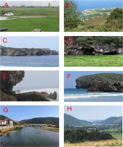
Figure 3. Examples of rasas, indicators of sea-level and palaeographic changes. (A) Rasas eroded on quartzites. There is one below the village of Pimiango at 160–162 m, and another at 150 m (herb packages); they are separated by a glacis. (B) Rasas cut on limestones. The village of Buelna rests on the one at 40-42 m; the one behing the village, near the coast is at 30–32 m. (C) Rasas and caves in limestones,as seen from Los Bufones de Arenillas. Rasas of La Tejera (16 and 31 m) in the first plane and, at the far end, Castro Bellota (40 m). Caves at 2–3 m elevation (Present) and at various elevations in the cliff. (D) Caves of possible marine origin at 65–66 m (Early Pleistocene), when there was a marine connection between Ensenada de Novales and Pendueles beach. At that time, the Piedrallada and Catariello hills formed an island. (E) A current notch, indicator of sea level, at Playa Vidiago; note in the upper part, the superimposition on an older notch. (F) Notches in Playa de Borizu: a fossil notch at 10–11 m and a current one at sea level. (G) Narrow v-shaped valley at the present mouth of the Deva River, as seen from Bustio-Unquera. (H) Fossil valley: abandoned tract with a flat bottom and mature slopes, between Unquera and Pesués.
The first ones (E-W) are related to the boundary between quartzites and sandstones and the Late Carboniferous limestones. These are parallel to the thrust directions (E-W), and some of them were active during the Quaternary as revealed by geomorphological indicators.
The second group (NNW-SSE) limits the blocks forming this sector, such as the eastern part of this area where the Tinas block, separated by these faults, was tilted.
El Pindal Cave area. Quartzitic materials to the south of the map are little permeable and, besides, the flat morphologies gently sloping towards the sea forming a staircase with steps separated by the old, degraded, marine escarpments, strongly favour the surface runoff and, as a consequence, the excavation of ravines that drain to the karstic system.
From the geomorphological point of view, 14 levels of major rasas on quarzite and limestones whose escarps range between elevations 223 m (R-1) and 31 m (R-14) above present sea-level (a.s.l.) were distinguished in El Pindal-Tinas.
The older (R-6 to R-9), cut on Ordovician quartzites, are well defined, with steps around 10 m high. The last one (R-9, elevation 149 m) stands 75 m above the Lower Carboniferous carbonates. This creates an anomaly that favours the generation of troughs and ravines that channel rain waters and runoff to the lower platforms where it is collected by the karstic depressions (dolines and poljes).
Rasas cut on carbonate rocks are less preserved as a consequence of karstification that led to the formation of dolines, poljes, lapiazes and caves, the superficial expression of which are little flat surfaces such as the San Emeterio lighthouse (over El Pindal cave). The rasa, here at elevation 65-66 m, corresponds to the middle galleries of the cave and it shows on surface a very well-developed lapiaz, strongly conditioned by the almost vertical dip (73° S) of the calcareous strata, which greatly favours the percolation of meteoric waters. The sequence of rasas on calcareous rocks is: 65-66 m San Emeterio lighthouse, 49-50 m Tina Monastery, 40 m ravine east of Ensenada de Moral, 30-31 m San Emeterio Point ( and ).
Figure 4. A general sequence of erosional marine terraces (rasas) and other paleo sea-level indicators at El Pindal-Tinas area.
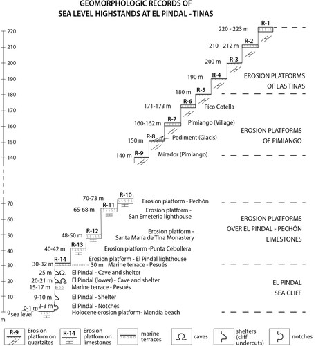
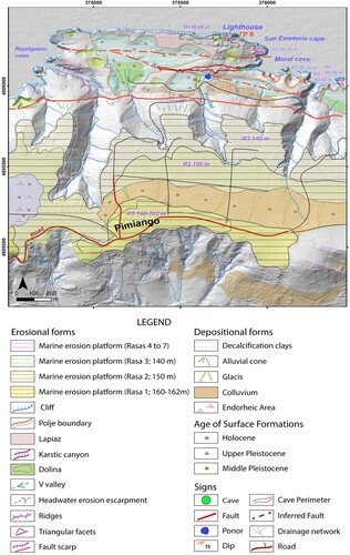
Figure 5. Geomorphological map of the area surrounding El Pindal cave.
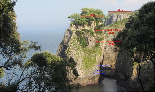
There are other morphologies indicative of former positions of sea level carved in the sea cliffs: caves (upper and lower El Pindal) at 25–24 and 20 m, shelters at 10 m, and notches at 4 and 2 m, such as the block in front of El Pindal cave (). All these indicators of paleo sea levels, plus the marine terraces, allow reconstructing a relative (in the absence of numeric dating) sequence of sea-level changes and getting information about the time and age when the water table (sea level) affected El Pindal cave ((C–F) and ).
Figure 6. Fallen block in front of the entrance of El Pindal cave.
With respect to morphotectonic aspects, from a structural point of view, this zone is marked by the fault boundary separating the Devonian quarzites and sandstones from the Devonian limestones. This E-W trending, old fracture, roughly parallel to the coast, was reactivated during the Quaternary as revealed () by a series of geomorphologic/tectonic features (fault escarpments, faceted surfaces, escarpments of retrograding erosion, anomalous incision of ravines). In addition, two recent faults affecting the Carboniferous limestones have generated karstic depressions (polje) elongated E-W and WNW-ESE. The latter deforms gently the northernmost part of the doline located to the south of the perimeter of cave galleries, and also affects the interior part of the cave, as recorded in the map ().
5. Discussion
In the General Area (Cuerres-Tina Menor) a differential behaviour of the pre-littoral mountain fronts is interpreted from the geomorphological map (). The more mobile are those to the west (south of Llanes), with four systems of encased alluvial fans, and to the east, in the fronts of Pimiango – Las Tinas block, with many geomorphologic indicators of recent activity. Carboniferous limestones are more soluble than the Cretaceous limestones of the eastern area. Referring to the Carboniferous rocks, the Namurian limestones show a better development of karstic features (dolines, poljes, uvalas, lapiazes, etc.) than those of Westphalian age. In addition are determined major palaeogeographical changes, such as:
A fossil fluvial valley between Unquera and Pesués, after abandonment by the Deva river (which formerly debouched in the Nansa) following a possible tilting of the Tina Mayor-Tina Menor block. Because of the tilting, the river changed its direction from W-E to N-S ((G,H)).
The incorporation to the mainland of the (present) Sierra Plana de Cué, a former island during the Early Pleistocene, as demonstrated by the surrounding marine terraces of this age.
With respect to uplift rates and the rasa at the beginning of the Quaternary, the chronology obtained by CitationÁlvarez-Marrón et al. (Citation2008) using cosmogenic nuclide acids near Cabo de Peñas at elevations 100 m (4 samples) and 90 m (1 sample) suggests a minimum age ca 1 Ma for this level, although the authors suppose that the true age could be around 1–2 Ma.
Using the minimum age of 1 Ma, the rasa marking the beginning of Quaternary should be at 259 m; using 1.5 Ma, at 172 m, and considering 2 Ma it should be at 130 m. All these elevations are found in the studied sequence: 259 m (R-3, Roñanzas plain), 172 m (R15, rasa of Pimiango-Pico Cotella), and 130 m (R-20, rasas of Sierra Plana de Cue).
Considering their uplift rates (between 0.07 and 0.15 mm/y), only the lower elevation is compatible with the local sequence, and the limit of the Quaternary should be placed at elevation 181 m.
We think that the most likely value is the rasa at 172 m. All those located at higher elevations should be assigned to the Pliocene. This is consistent with an uplifting area and it coincides with an observed change of trend () in the encasements and in the separation between successive rasas. In any case, it cannot be ruled out that the limit be at lower elevations.
El Pindal Cave Area. The geomorphological map (1:10.000 scaled) presents the main rasas and their place on quarzitic and carbonate rocks, and gives a spatial view of the morphology of the terrain and the possible effects of extraordinary rains on the flooding of karstic depressions connected to El Pindal endokarstic system.
The morphology of rasas eroded on quartzite (between 160 and 180 m) is almost a flat surface. The low permeability (limited to fissures) coupled to a difference of some 75 m in elevation as compared with the surfaces eroded on carbonates (140 m the youngest on quartzite, 65 m the oldest on limestone) led to the excavation of several ravines that drain the runoff either to the sea through karstic canyons, or (the three in the centre) to the karstic depressions (dolines, poljes) that are, direct or indirectly, related to the galleries of the cave. The Westphalian limestones are strongly tectonized and fissured all around this area, making them very easy to dissolve, which accounts for the large observed karstic system. Besides, the steep dip (70–75° S) greatly favours infiltration along stratification surfaces.
The most significant depressions are two poljes elongated E-W and NNW-SSE. The first one lays on the San Emeterio rasa and is the largest geomorphological unit clearly related to the inner gallery of the cave. The bottom of the polje is between 30 and 40 m.a.s.l., whereas the main inner gallery develops between 30 and 20 m a.s.l. Thus, it is most likely that the polje supplied sporadically water to the cave. The bottom of the second polje, located to the south of the cave but topographically higher, is at 40-35 m, making it very likely that it might be connected to the cave.
The third main karstic morphology is the doline located to the SW of the cave, and connected to it by a ponor associated to the NNW-SSE fracture ().
The deduced fractures that affect the poljes also influence the hydrologic aspects of the cave: the more oriental rectifies the deeper, inner gallery, whereas the rectilinear, external gallery is affected by the E-W fault indicated by CitationJiménez-Sánchez et al. (Citation2002).
From the general sequence and the geomorphological map ( and ), it is deduced that there are at least 14 positions of sea level in this sector during the Quaternary. The number rises to 22 between El Pindal and Tinas.
Eight staircased rasas eroded on quartzites between 220 and 140 m a.s.l. that may correspond to the Early Pleistocene. Five eroded on limestones (70–30 m a.s.l.) assigned to the Middle Pleistocene (relative chronology) at elevations: +70–73 m, +65–66 m, +48–50 m, +40–42 m, +30–32 m (roof of the main gallery of El Pindal cave). In addition to these morphologies, there are marine deposits and indicators of highstands at +24–25 m (Pindal cave entrance), +20–21 m (floor of the main gallery), +15–17 m, +9–10 m, +2–3 m, and +1 m near El Pindal, which, in some cases coincide with the indicated figures ( and ).
With respect to uplift rates and the minimum age of the cave – El Pindal Cave area, the calculations of the minimum age of the cave are based on the elevation and age of the MIS 5e marine terrace in Oyambre beach (CitationSanz de Murieta et al., Citation2021), located some 16 km far from El Pindal.
The marine deposit occurs at an elevation of 9.2 m a.s.l. and its age is ca. 130 ka. Considering that sea level was 6 ± 4 m higher than present (CitationPedoja et al., Citation2018), the difference in elevation (3.2 m) corresponds to a post-depositional rise of the littoral; this results in a rate of uplift of 0.0248 mm/a, for the last 129 ka.
The following interglacials with sea levels higher than the present are MIS 9 and MIS 11. During MIS 9 (334 ka) the sea level was 3 ± 2 m higher than the present, whereas during MIS 11 (420 ka) sea level was 9.5 ± 3.5 m higher (CitationPedoja et al., Citation2018). Applying a constant rate of elevation of 0.0248 mm/y to these marine episodes the obtained values are 8.28 and 10.42 m respectively. But, considering the difference in elevation of these highstands with the present, the values are corrected to 11.28 m for MIS 9 and 19.92 for MIS 11. The last elevation coincides with the floor of the main Gallery of El Pindal cave, placed 4–5 m below the entrance of El Pindal cave. The next interglacial highstand MIS 15 (612 ka) was lower than both the present and the MIS 11 (CitationBerger et al., Citation2016; CitationCapron et al., Citation2019; CitationPatridge, 1997; CitationShackleton, Citation1995; CitationSiddall et al., Citation2006). Using this rate, each metre of uplift would require 40,323 years; this, added to the 420 ka of the MIS 11 means 601,453 years for the MIS 15, but as the sea level was then lower than the present, it is still lower than the El Pindal cave. In consequence, the MIS 15 (568–612 ka) can be used as a minimum age, but a probable age should be between MIS 15 and MIS 25 (ca. 970 ka), when the sea level was higher than the present according to the cited authors.
6. Conclusions
A geomorphological map of the sequence of erosive surfaces (rasas) and marine deposits on quarzitic and carbonate substrata in the study area. No repeated sequences were observed. The topographically higher rasa (275 m) is at Llano de Roñanzas, and the probable limit of the Quaternary coincides with at the one at elevation 172 m, which means a rate of uplift 0.066 mm/y. A different geomorphological behaviorof the main E-W faults affecting the boundary of the Ordovician quartzites and the Carboniferous limestones. The largest neotectonic activity takes place south of Llanes (Cuera range) and El Pindal-Tinas area, as revealed by geomorphologic indicators. There were possible movements of blocks along NNW-SSE faults which changed the courses of the rivers Deva and Nansa and the abandonment of the paleovalley of the Deva river between Unquera and Pesués during the Early Pleistocene. Also a deduction of (supposed) E-W fractures that affect El Pindal cave and favoured the genesis of the E-W elongated Tronía-San Emeterio polje which coincides with the external galleries of the cave. Other fractures directed NNW-SSE are responsible of the narrow, elongated polje at San Emeterio hermitage, and the inner galleries of the cave. In the event of heavy rains, the cave collects the waters of these two poljes and the doline located to the south all of which can accumulate a large amount of water to be added to waters flowing along the three valleys debouching in these karstic depressions and runoff along the subvertical dip (70° S) from Pimiango Viewpoint to this karstic system. Using the available uplift rates, the age of El Pindal cave is assigned to the MIS 15 (568-612 ka), most probably between MIS 15 and MIS 25 (ca. 970 ka).
Software
ArcGIS v10.9 with extensions Spatial Analysis, 3D Analysis and Geostadistics was used, with vectorial (dots, lines and polygons) and raster (ortophotos) formats. Working scale was 1:25.000 with Universal Transverse Mercator UTM-Datum – ETRS 89 in huse 30 as coordinates system.
Supplemental Material
Download Zip (21.4 MB)Disclosure statement
No potential conflict of interest was reported by the author(s).
Data availability statement
The scientific data obtained in this work are published in the text of the article. However, any extension or detail can be requested from the corresponding author.
Additional information
Funding
References
- Adrados, L. (2014). Costa oriental de Asturias. Un paisaje singular. Excursiones geológicas a pie y en kayak. Adrados Ediciones. Asturias. 302 pp.
- Alonso, J. L., & Pulgar, A. (1995). 8-La estructura de la Zona Cantábrica, 103–112. In: Geología de Asturias (Aramburu & Bastida, Eds), 314 pp.
- Álvarez-Marrón, J., Hetzel, R., Niedermann, S., Menéndez Duarte, R., & Marquínez, J. (2008). Origin, structure and exposure history of a wave-cut platform more than 1 Ma in age at the coast of northern Spain: A multiple cosmogenic nuclide approach. Geomorphology, 93(3-4), 316–334. https://doi.org/10.1016/j.geomorph.2007.03.005
- Ballesteros, D., Giralt, S., García-Sansegundo, J., & Jiménez-Sánchez, M. (2019). Quaternary regional evolution based on karst cave geomorphology in Picos de Europa (Atlantic margin of the Iberian Peninsula). Geomorphology, 336, 133–151. https://doi.org/10.1016/j.geomorph.2019.04.002
- Berger, B., Crucifix, M., Hodell, D. A., Mangili, C., McManus, J. F., Otto-Bliesner, B., Pol, K., Raynaud, D., Skinner, L. C., Tzedakis, P. C., Wolff, E. W., Yin, Q. Z., Abe-Ouchi, A., Barbante, C., Brovkin, V., Cacho, I., Capron, E., Ferretti, P., Ganopolski, A., … Vazquez Riveiros, N. (2016). Interglacials of the last 800,000 years. Reviews of Geophysics, 54(1), 162–219. https://doi.org/10.1002/2015RG000482
- Capron, E., Rovere, A., Austermann, J., Axford, Y., Barlow, N. L. M., Carlson, A. E., De Vernal, A., Dutton, A., Kopp, R. E., McManus, J. F., Menviel, L., Otto-Bliesner, B. L., Robinson, A., Shakun, J. D., Tzedakis, P. C., & Wolf, E. W. (2019). Challenges and research priorities to understand interactions between climate, icesheets and global mean sea level during past interglacials. Quaternary Science Reviews, 219, 308–311. https://doi.org/10.1016/j.quascirev.2019.06.030
- Domínguez-Cuesta, M. J., Jiménez-Sánchez, M., & González-Fernández, J. A. (2013). Detección de rasas mediante SIG en la costa oriental de Asturias (N de España). Geo-temas 14, 63–66, VII Jornadas de Geomorfología Litoral. Oviedo.
- Domínguez-Cuesta, M. J., Jiménez-Sánchez, M., González-Fernández, J. A., Quintana, L., Flor, G., & Flor-Blanco, G. (2015). GIS as a tool to detect flat erosional surfaces in coastal areas: A case study in North Spain. Geological Acta, 14, 97–106.
- Duque, L. C., & Elizaga, E. (1983). Puntos de interés geológico en el sector oriental de la Cordillera Cantabrica. Instituto Geológico y Minero de España (IGME). 76 pp.
- Flor, G. (1983). Las rasas asturianas: ensayos de correlación y emplazamiento. Trabajos de Geología, 13, Univ. Oviedo, 65–81.
- Flor, G., & Flor-Blanco, G. (2009). Guía de Campo. Aspectos morfológicos, dinámicos y sedimentarios del sector costero: desembocadura del Nalón-playa de Bañugues. Problemática ambiental. 6° Simposio sobre el Margen Ibérico Atlántico (MIA09).
- Flor, G., & Flor-Blanco, G. (2014a). Área de Cabo de Peñas. Guía de Campo de Geología Marina (Grado en Geología), 33–67. Facultad de Geología. Servicio de Publicaciones. Universidad de Oviedo. 132 pp.
- Flor, G., & Flor-Blanco, G. (2014b). Raised beaches in the Cantabrian coast. In F. Gutiérrez, & F. Gutiérrez Elorza (Eds.), Landscapes and landforms in Spain. World geomorphological landscapes (pp. 239–248). Springer Science + Business Media Dordrecht.
- García-Ramos, J. C., & Gutiérrez Claverol, M. (1995). La cobertera mesozoico-terciaria. 8–94. In: Aramburu, C. & Bastida, F. (Eds.). Geología de Asturias. 314 pp.
- Garzón, G., Alonso, A., Torres, T., & Llamas, J. (1996). Edad de las playas colgadas y de las turberas de Oyambre y Merón (Cantabria). Geogaceta, 20(2), 498–501.
- Gómez de Llarena, J., & Royo Gómez, J. (1927). Las terrazas y rasas litorales de Asturias y Santander. Boletín de la Sociedad Española de Historia Natural, XVII, 15–38.
- González, M. J., Serrano, E., Edeso, J. M., & Meaza, G. (2005). Cambios en el nivel del mar durante el Cuaternario y Morfología litoral en la costa oriental cantábrica (País vasco y Cantabria). 167–180 Geomorfologia litoral i Quaternari. (Eds Sanjaume, Mateu). Universitat de Valencia. Valencia.
- Guilcher, A. (1974). Les «rasas»: un problème de morphologie littorale générale. Annales de Géographie, 455(455), 1–33. https://doi.org/10.3406/geo.1974.18924
- Gutiérrez Claverol, M., López Fernández, C., & Alonso, J. L. (2006). Procesos neotectónicos en los depósitos de rasa de la zona de Canero (Occidente de Asturias). Geogaceta, 4, 75–78.
- Hernández Pacheco, F. (1956). Síntesis orográfica y orogénica de la península hispana. Boletín de la Real Sociedad Española de Historia Natural, LIII, 31–77.
- Hernández Pacheco, F. (1957). Las rasas de la costa cantábrica en el segmento oriental de Asturias. V Congr. Intern. del INQUA. Oviedo.
- Hernandez Pacheco, F., & Asensio Amor, I. (1963). Materiales sedimentarios sobre la rasa cantábrica. V. Tramo comprendido entre el valle del río Porcía y la ría del Eo. Boletín de la Real Sociedad Española de Historia Natural, 30, 159–172.
- Hernández Pacheco, F., & Asensio Amor, I. (1964). Recientes investigaciones sobre la génesis de la rasa litoral cantábrica. Tramo final del valle del río Navia (Asturias). Boletín de la Real Sociedad Española de Historia Natural, 62, 61–89.
- Hernández Pacheco, F., Llopis Llado, N., Jorda Cerda, F., & Martínez, J. A. (1957). Libro guía de la excursión N2. El cuaternario de la región cantábrica (22–31 Agosto 1957). INQUA, V. Congr. Intern., pp. 7–72, 9 fig., 2 mapas, fuera texto, Oviedo. I.G.M.E. (1973).
- Hoyos Gomez, M. (1987). Upper Pleistocene and Holocene marine levels on the Cornisa Cantabrica, (Asturias, Cantabria and Basque country) Spain. In C. Zazo (Ed.), Late quaternary sea-level changes in Spain Trabajos sobre Neogeno-Cuaternario n° 10 (pp. 251–258). Museo Nacional de Ciencias Naturales.
- Hoyos Gomez, M. (1989). La Cornisa Cantábrica., 105–118. In: Mapa del Cuaternario de España, E. 1/1.000.000. Instituto Geológico y Minero de España (IGME).
- Jiménez-Sánchez, M., Anadón-Ruiz, S., Farias, P., García-Sansegundo, J., & Canto-Toimil, N. (2002). Estudio preliminar de la Geomorfología de la Cueva del Pindal (Ribadedeva, Oriente de Asturias). Geogaceta, 31, 47–50.
- Jiménez-Sánchez, M., Bischoff, J. L., Stoll, H., & Aranburu, A. (2006). A geochronological approach for cave evolution in the Cantabrian Coast (Pindal Cave, NW Spain). Zeitschrift für Geomorphologie, 147, 129–141.
- Jiménez-Sánchez, M., Canto Toimil, N., & Anadón Ruiz, S. (2004). Caracterización estratigráfica del relleno sedimentario de la Cueva del Pindal (Ribadedeva, Asturias): implicaciones geomorfológicas. In: Flor, G. (ed.): Actas de la XI Reunion de AEQUA: 151–158.
- Llopis Lladó, N. (1962). Mapa Geológico de Asturias. Hojas n° 1 y 2. Estudio de la región de Cabo Peñas. Real Instituto de Estudios Asturianos. 116 pp. 10 pls. 2 mapas. Oviedo.
- López-Fernández, C., Llana-Fúnez, S., Fernández-Viejo, G., Domingues-Cuesta, M. J., & Diaz-Diaz, L. M. (2020). Comprehensive characterization of elevated coastal platforms in the north Iberian margin: A new template to quantify uplift rates and tectonic patterns. Geomorphology, 364(1-13), 107242. https://doi.org/10.1016/j.geomorph.2020.107242
- Mary, G. (1970). Dépôts marins et éolisation anciene près du phare de Peñas. Breviora Geológica Astúrica, 14(3), 29–32.
- Mary, G. (1971). Les formations quaternaires de la côte asturienne (Espagne) entre Ribadesella et Comillas. Bull AFEQ, 2, 11–18.
- Mary, G. (1983). Evolución del margen costero de la Cordillera Cantábrica en Asturias desde el Mioceno. Trabajos de Geología, 13, 3–35.
- Mary, G. (1985). Les éboulis périglaciaires le long du littoral asturien et galicien, in: Actas I Reunión Del Cuaternario Ibérico. pp. 119–126. Martinez Garcia, E., 1981. Hoja Geológica de España, E. 1:50.000 (2ª serie). Llanes (32). Instituto Geológico y Minero de España (IGME).
- Mary, G., Mendus, J., & Delibrias, G. (1977). Documents sur l’évolution de la flore du littoral nord espagnol au Würm. In: Recherches francaises sur le Quaternaire, INQUA. BULL AFEQ, 50(Suppl. 19), 23–31.
- Moñino, M., Díaz de Terán, J. R., & Cendrero, A. (1988). Pleistocene sea level changes in the Cantabrian coast, Spain. In S. Singh, & R. C. Tiwari (Eds.), Geomorphology and environment (pp. 351–356). The Allahabad Geographical Society.
- Moreno, F., Mediato, J. F., & Canas, V. (2009). Terrazas marinas en el litoral de Cantabria. Controles litológicos del sustrato. 6° Simposio sobre el Margen Ibérico MIA09, 181-184.
- Navarro, D., & Leyva, F. (1996). Hoja Geológica de España E.1:50.000 (2ªserie). Ribadesella (31). Instituto Geológico y Minero de España (IGME).
- Partridge, T. C. (1997). Reassessment of the position of the Plio-Pleistocene boundary: Is there a case for lowering it to the Gauss-Matuyama palaeomagnetic reversal? Quaternary International, 40, 5–10. https://doi.org/10.1016/S1040-6182(96)00054-7
- Pedoja, K., Husson, L., Johnson, M. E., Melnick, D., Witt, C., Pochat, S., Nexer, M., Delcaillau, B., Pinegina, T., Poprawski, Y., Authemayou, C., Elliot, M., Regard, V., & Garestier, F. (2014). Coastal staircase sequences reflecting sea-level oscillations and tectonic uplift during the Quaternary and Neogene. Earth Science Reviews, 132, 13–38. https://doi.org/10.1016/j.earscirev.2014.01.00.7.
- Pedoja, K., Husson, L., Regard, V., Cobbold, P. R., Ostanciaux, E., Johnson, M. E., Kershaw, S., Saillard, M., Martinod, J., Furgerot, L., Weill, P., & Delcaillau, B. (2011). Relative sea-level fall since the last interglacial stage: Are coasts uplifting worldwide? Earth-Science Reviews, 108(1-2), 1–15. https://doi.org/10.1016/j.earscirev.2011.05.002
- Pedoja, K., Jara-Muñoz, J., De Gelder, G., Robertson, J., Meschis, M., Fernandez-Blanco, D., Nexer, M., Poprawski, Y., Dugué, O., Delcaillau, B., Bessin, P., Benabdelouahed, M., Authemayou, C., Husson, L., Regard, V., Menier, D., & Pinel, B. (2018). Neogenequaternary slow coastal uplift of Western Europe through the perspective of sequences of strandlines from the Cotentin Peninsula (Normandy,France). Geomorphology, 303, 338–356. https://doi.org/10.1016/j.geomorph.2017.11.021
- Portero, J. M., Ramírez del Pozo, J., Olivé, A., & Martin Alafont, J. M. (1976). Hoja Geológica de España, E.1:50.000 (2ªserie). Comillas (33). Instituto Geológico y Minero de España (IGME).
- Remondo, J. (2020). Relief and active processes in the Cantabrian mountains. In C. Quesada, & J. T. Oliveira (Eds.), 5-Active landscapes of iberia in:The Geology of Iberia: A geodynamic approach (pp. 87–90). Springer Nature Switzerland.
- Sanz de Murieta, E., Cunha, P. P., Cearreta, A., Murray, A. S., & Buylaert, J. P. (2021). The Oyambre coastal terrace: A detailed sedimentary record of the Last Interglacial Stage in northern Iberia (Cantabrian coast, Spain). Journal of Quaternary Science, 36(4), 570–585. https://doi.org/10.1002/jqs.3317
- Shackleton, N. J. (1995). New data on the evolution of Pliocene climatic variability. In E. S. Vrba, G. H. Denton, T. C. Partridge, & L. H. Burckl (Eds.), Paleoclimate and evolution with emphasis on human origins (pp. 242–248). Yale University Press.
- Siddall, M., Chappell, J., & Potter, E. K. (2006). Eustatic sea level during past interglacials. In F. Sirocko, M. Claussen, T. Litt, & M. F. Sanchez-Goni (Eds.), The climate of past interglacials (pp. 75–92). Elsevier Science.