
Abstract
With the increased recognition that bicycling is a sustainable transportation mode choice, there is a continued interest in understanding how the built environment affects bicyclist travel behavior. Research on the influence of small-scale built form elements, such as street characteristics, on bicyclist wayfinding is limited. wayfinding is defined as a purposeful way of reaching from point A to point B; it is comprised of decision-making and subsequent movement. This research uses an agent-based model to investigate how small-scale urban design affects bicyclist wayfinding. Using geographic information systems and statistical analysis, different types of simulated bicycle agents were compared to observed bicycle volumes. Statistically significant positive relationships between bicycle agent types and observational data existed. The largest correspondence between agents and field observations occurred along central routes that were accessible from other streets (R2 = .377) and that had fewer decision-making junctions (R2 = .352). Bicyclists selected streets that were wider and with fewer obstructions to one’s forward view. The results support the need to design streetscapes that offer a high level of visibility and reduced stops to promote bicycling. The study also describes a modeling approach that can be replicated by urban planners to understand bicyclist travel patterns.
Introduction
Many communities in the United States remain eager to integrate sustainable transportation systems that promote health and reduce automobile reliance. In the US, approximately two-thirds of the population is sedentary; health care costs associated with inactive lifestyles exceed $24 billion (Colditz, Citation1999; Pratt, Macera, & Blanton, Citation1999). To reduce these extraordinary health care costs, one solution is to increase physical activity by using bicycling for daily travel purposes (Frank, Engelke, & Schmid, Citation2003). Moreover, transferring a portion of daily automobile trips to bicycling will result in decreased air and noise pollution (Litman, Citation1994), reduced traffic congestion (Lee, Citation1986), lower energy costs (Komanoff & Roelofs, Citation1993), and improved environmental quality (Newman & Kenworthy, Citation1999). Several US legislative acts such as the Intermodal Surface Transportation Efficiency Act (ISTEA), the Transportation Enhancement Act for the twenty-first century (TEA-21), and safe, accountable, flexible, efficient transportation equity act: a legacy for users (SAFETEA-LU) seek to increase bicycling rates; still, bicycling trips accounts for nearly 1% of all trips in US cities (Handy, Xing, & Buehler, Citation2010). Policy-makers, planners, and researchers, therefore, continue to investigate what factors may contribute to elevated bicycle mode choice.
Due to the clear benefits of bicycling, past research has investigated what factors will increase bicycling. Only a minimum amount of work has investigated in detail how small-scale (i.e. microscopic) urban form elements such as building and street design can affect bicycling rates. Rather, prior research has focused on the influence of land-use diversity (Frank et al., Citation2003), trip distance (Parkin, Ryley, & Jones, Citation2007), socio-demographics (Heinen, Wee, & Maat, Citation2010), topography (Rodríguez & Joo, Citation2004), personal attitudes (Gatersleben & Haddadb, Citation2010), and urban density (Frank et al., Citation2003) on bicycling. Prior investigations determined that direct routes (McDonald & Burns, Citation2001), dense intersections (Winters, Brauer, Setton, & Teschke, Citation2010) configured roads (Cervero & Kockelman, Citation1997), presence of bicycle facilities (Dill, Citation2009; Pucher, Dill, & Handy, Citation2010), road safety (Landis, Vattikuti, & Brannick, Citation1997), warmer weather (Saneinejad, Roorda, & Kennedy, Citation2012), and presence of built form (Winters et al., Citation2010) promote bicycling. Most prior studies used surveys (Rodríguez & Joo, Citation2004), geographic information systems (GIS) (Aultman-Hall, Hall, & Baetz, Citation1997), indices (Black, Citation2010), and discrete choice models (Cervero & Duncan, Citation2003; Frank, Bradley, Kavage, Chapman, & Lawton, Citation2008) to determine what factors contribute to increased bicycling rates.
The planning field has recognized that human systems are multidimensional and irrational and require the use of progressive modeling techniques (Penn & Turner, Citation2003). In terms of bicycling, Raford, Chiaradia, and Gil (Citation2007) suggested that like pedestrians and car movement, bicycling is an emergent phenomenon. Despite this, top-down modeling approaches that are static and utilize aggregated datasets remain a popular method to predict bicycle travel behavior. The primary faults with such models and datasets are their vague inclusion of bicyclist perception factors, exclusion of precise urban design metrics, and use of homogenous utility functions (Andriotti, Citation2006; Axelrod, Citation1997; Katz, Citation1995; McCahill & Garrick, Citation2008; Porter, Suhrbier, & Schwartz, Citation1999). For example, discrete choice models were used to predict an individual’s willingness to commute via bicycle based on summarized independent variables such as land-use mix, neighborhood design, connectivity, bicycle facility design, and socio-demographic variables (Barnes & Krizek, Citation2005; Frank & Pivo, Citation1995). While such research illustrated the important influence of environmental and social facilitators on bicycling, it did little to explain the strategies bicyclists use while determining their route choices within an urban environment with varying spatial qualities. A recent study by Dill (Citation2009) used global positioning systems (GPS) to record individual bicyclist behavioral choices along a street network to derive microscale movement patterns. While the linkages between built form and bicycling are evident, advanced methods that fully describe how microscale urban morphology elements affect the evolution of individual bicycling travel behavior continues to be a strong research need (Dill, Citation2009; Ronald, Sterling, & Kirley, Citation2009; Winters et al., Citation2010).
To date, there are minimal investigations that have utilized bottom-up approaches to highlight built environment effects on bicyclist wayfinding ability. Wayfinding is defined as a purposeful and meaningful way to reach from point A to point B; it is comprised of decision-making and subsequent movement (Allen, Citation1999). Prior research primarily focused on pedestrian wayfinding. For example, Raubal and Winter (Citation2002) discovered that tourists who walked utilized topological knowledge, inherent knowledge, and habits from previous movements to guide wayfinding. Pedestrian wayfinding was also heavily influenced by natural or man-made landmarks, such as buildings, tree stands, or street corners (Golledge, Citation1999; Peponis, Zimring, & Choi, Citation1990). Travel route identification, route preferences, personal differences, and landmark utility were other factors influencing pedestrian wayfinding (Xia, Arrowsmith, Jackson, & Cartwright, Citation2008). Building on prior studies that have explored the connections between wayfinding performance and the built environment, this research explores the degree to which urban form and visibility affects bicyclist wayfinding success in a virtual environment. A space syntax inspired agent-based model (ABM) was utilized to capture the evolution of emergent bicycle travel behavior in an urban environment. To test the usefulness of the model in predicting bicyclist wayfinding success and for determining bicyclist built form preferences, bicyclist agent trails were compared to observation data. The article concludes with important findings and implications for sound bicycle facility planning strategies.
Background
Agent-based modeling and space syntax
In the Background section, prior research findings on the utility of space syntax ABMs are discussed. Agent-based modeling offers three benefits over stochastic, top-down, empirical models, (1) heterogeneous individual behavior is integral in the model development, (2) nonlinear human travel can be accommodated, and (3) simulation modeling is less data intensive than traditional static models (Groff, Citation2007). Unlike typical top-down modeling approaches which apply over-arching equations and assumptions to the system, ABMs provide a means to understand the unexplainable human-environment relationship (Najlis & North, Citation2004). ABMs account for the evolution of disaggregated behaviors of individuals and their system-wide effects. An example of this is commonly witnessed when congestion ensues after new travel lanes are added to roads; an occurrence commonly known as “induced traffic.” In this example, a traditional model would not be able to capture the effects of an increased use of the roadway and ensuing congestion because it is dynamic and a nonlinear outcome. For this reason, ABMs have been instrumental in stock market prediction (Bonabeau, Citation2002), designing of store layouts (Bonabeau, Citation2002), transportation modeling (Batty, Desyllas, & Duxbury, Citation2003; Chen, Meaker, & Zhan, Citation2006), pedestrian activity (Torrens, Citation2012), urban planning (Jackson, Forest, & Sengupta, Citation2008), and crime analysis (Groff, Citation2007). A type of ABM that relies on urban form and vision is space syntax.
Space syntax ABMs have proven successful in modeling pedestrian behavior (Penn & Turner, Citation2002). The success of space syntax ABMs is attributed to their foundational connections to isovist analysis. Isovist analysis was proposed by Benedikt (Citation1979) as a means to quantify the perceptual experience of a space. Simply stated, an isovist is an area visible from any space in the system. Isovist theory posits that people instantaneously react to the changing spatial relationships within a viewing area. Gibson (Citation1979) promoted a related theoretical construct entitled: ecological theory of perception. The theory stated that perceived environmental affordances drive human movement. To put another way, humans inherently view space in optic arrays and the visual information contained within them aids with navigation. A similar theory posited by Hillier, Penn, Hanson, Grajewski, and Xu (Citation1993) stated that “natural movement” details the importance of spatial configurations in generating human traffic. Furthermore, natural movement has been suggested as the strongest determinant of human movement flows in urban environments (Hillier et al., Citation1993; Hillier & Vaughan, Citation2007). Hillier (Citation2006) also stated that people largely respond to cities visually more so than in real, metric distances.
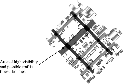
Building on the theories discussed above, visibility graph analysis (VGA) is used in the development of space syntax ABMs. Visibility analysis is used in space syntax-based ABMs. VGA measures the spatial characteristics of locations from multiple positions within the environment (Franz and Wiener, Citation2008). The basic assumptions of VGA are that longer lines of sight, reduced path angularity, and integrated (i.e. connected) spaces facilitate efficient wayfinding. Additionally, VGA has been correlated to notions of wayfinding, movement, and space use (Turner, Citation2003). Figure was produced using VGA. It depicts areas with elevated visibility and connectivity. These areas have strong potential to generate high traffic flows. VGA produces a raster surface containing pixels. The pixels depict urban form and visibility metrics derived from the built environment. Visibility graphs such as the one presented in Figure have been used to assess human wayfinding, use of space, and human movement (Desyllas & Duxbury, Citation2001; Turner, Citation2001). In space syntax ABMs, agents utilize VGA to provide vision and guidance during all route decisions. The space syntax ABM also allows the user to define the parameters, the number of steps an agent can take, the starting point, and the urban form and visibility rules (Turner, Citation2000). The ABM rules that have shown correlations to human movement include the following: occlusions, angularity, and integration have demonstrated strong correlations to human movement (Turner & Penn, Citation1999). For instance, a study by Dalton (Citation2003) discovered that minimizing angularity was an effective natural movement agent rule and Mottram, Conroy, and Turner (Citation1999) designed agents to maximize lengths of sight with moderate success. Additionally, Raford, Chiaradia, and Gil (Citation2005) used a space syntax ABM and discovered that bicyclists largely conform to spatial logic when selecting routes.
Figure 1. Space syntax vision based metric, integration.
Study area
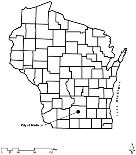
The study area used in this research is the City of Madison, Wisconsin. Madison, part of Dane County, is a medium-sized city with a population of approximately 223,389 and is the home to the University of Wisconsin (Figure ). As a typical college town, the bicycle mode share is above the national average, thus providing a prime study area for bicycle-related research. Bicycling in the city accounts for 3.2 of work trips and 2.4% of all trips. Bicycling Magazine designated Madison as one of the most bicycle-friendly cities in the country in the 200,000–500,000 population range. The city also received the second highest designation by the League of American Bicyclists under its Bicycle Friendly Community Program (Schaefer, Citation2008). The relatively high use of bicycles in Madison has been attributed to a well-developed bikeway system, extensive bicycle/pedestrian planning, unique land-use pattern, significant commercial bicycle industry, and strong bicycle culture. Unfortunately, like many cities in the US, Madison faces congestion problems (Schaefer, Citation2008). Sixty-five percent of commuters use single-occupant-vehicles (SOVs) (Schaefer, Citation2008).
Figure 2. City of Madison.
Data sources and preliminary GIS work
The Dane County, WI add-on sample from the 2001 US National Household Travel Survey (NHTS) was used in this research to obtain individual utilitarian (i.e. regular and non-recreational) bicycle mode choice and residential trip origins. The NHTS was conducted over a one-year period from 1 May 2001 through 6 May 2002. The Dane County census add-on sample was comprised of 2841 households, 6210 persons, 26,351 any trips, and 6601 long distance trips reported. Each survey respondent starting trips from home via bicycle for non-recreational purposes was selected using geographic information software. The start of these trips served as the bicycle agent trip origins. Available bicycle routes in this research consisted of road right-of-ways (ROW). ROWs are defined as roads legal for bicycling; they exclude highways and service roads. In addition, all bicycle off-street trails were included.
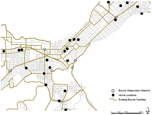
In addition to the NHTS survey data, bicycling observation data on counts of bicyclists for seven locations within the study area were obtained from the Dane County Land Information Office and the City of Madison’s Engineering Department. They were used in this study to compare actual bicyclist route choices to virtual bicyclist agent route choices. These bicyclist observations were collected in the years 2000 and 2007 for most stations. All bicyclist observation count stations were located near the CBD and other traffic generators such as the University of Wisconsin and state capital (Figure ). As a result, minimal variation in bicycling activity between these years was expected. The bicyclist observations were collected hourly using a triggered counting strip. Due to the limited number of observation field stations, a localized interpolation technique, inverse distance weighting (IDW), was used to estimate missing bicycle counts. IDW is a common GIS method to estimate unknown values (Clarke, Citation1997). The estimated IDW bicyclist counts for the entire study area were then joined to the existing traversable ROWs using Esri GIS version 9.3. However, only the ROWs within 500 feet of the observation stations (n = 75) were used for statistically comparing bicyclist field counts to bicycle agents. The buffer distance and resulting ROWs used for statistical comparisons were chosen in order to minimize possible variations in urban design and visibility clues.
Figure 3. CBD of Madison, WI, bicyclist residence and bicyclist observation stations.
Bicycle agent design and statistical approach
The bicycle agents were linked to all viable ROWs and off-street trails within the central business district of Madison, WI (Figure ). ROWs were converted to CAD format using GIS software and then imported into Depthmap 8.15 software. A VGA raster surface with a step resolution (virtual agent steps) of 8 m and grid spacing of 100 m2 was produced in order to provide a basis for bicyclist movement. This step resolution was selected because it is approximately ten times the spacing of a pedestrian ABM due and is representative of bicyclist movement rates. The raster surface resulted in approximately 111,088 possible bicycle agent access points. It contained several vision and urban form indices. The release points for the bicyclist agents consisted of 25 randomly selected NHTS residential locations. Upon entering the system, agents followed a trajectory for a total of six random steps before making their next travel decision using the agent rule at hand. The 6-step rule was put in place to represent a feasible bicycle travel decision point using an urban design or visibility metric. These agents were designed to move at an approximate speed of 12 mph and make a travel decision after 48 m (the 6th step or approximately 23 s). An additional agent rule utilized in this research is that two agents cannot occupy the same cell at the same time, nor are they allowed to continually walk into objects. This aversion tactic forces the agents to select a new random direction when confronted with another agent or obstacle to prevent gridlock. Bicycle agent trails from each set of agents were recorded for the 75 ROWs within 500 feet of the bicycle count stations.
A non-causal statistical approach was implemented to determine the relative strength of covariance between the bicycle agents and the field data. The focus of correlation analysis is to highlight negative or positive relationships between two variables, and in turn, spur in-depth explanatory thought. The goal in this research is to highlight significant linear associations between contrasting bicycle agent wayfinding patterns and actual bicyclist counts, therefore, validating the use of correlation analysis. To enhance any associations, the estimated observations and bicycle agent values were log transformed due to the non-normal distribution of data values. Previous research indicates that a stronger linear associations can be found with a logarithmic transformation of space syntax and observation variables (Hillier et al., Citation1993; Penn & Turner, Citation2002). In order to distinguish how vision and urban morphology affect bicyclist wayfinding, three different bicycle agent types were constructed: urban morphology, vision, and system-wide (global) properties.
Urban morphology agent parameters
Previous research has found strong correlations among several VGA metrics and human movement. To remain in line with this prior research, VGA factors, clustering coefficient, integration, mean depth, and mean entropy were employed during the development of bicyclist agent rules. The clustering coefficient index was first posited by Watts and Strogatz (Citation1998) and relates to the potential information loss or gain as one travels in an environment. The clustering coefficient metric was included in this study due to its ability to predict pedestrian movements (Penn & Turner, Citation2002). The metric represents the number of vertices that are connected to other vertices in the neighborhood, compared to the quantity of vertices that could be connected (Turner, Citation2004). Increased coefficients may reach a maximum of one when every point in the convex polygon is visible. For example, public squares may possess a coefficient close to one. On the other hand, reduced coefficients represent areas with elevated spatial complexity due to the increased presence of junctions. It has been proposed that these junctions can be construed as human wayfinding mechanisms (Penn & Turner, Citation2002). Integration, which has been utilized in this research, can be inferred as a measure of centrality for to-movements (Hillier & Vaughan, Citation2007). In other words, streets that are highly accessible in relation to other streets tend to be used for reaching a destination more often than less integrated streets (Raford & Ragland, Citation2004). A street with a high integration index can be interpreted as a major thoroughfare. Mean depth is analogous to the integration metric. It measures how visually connected a space is to the remaining spaces in the system (Turner, Citation2004). Because mean depth is a strong correlate to pedestrian movement, it has been included in this research (Turner, Citation2004). Mean entropy is the final VGA rule applied to the virtual bicyclist agents. Entropy is a measure of the visual accessibility of other spaces in the environment. The index is low when visual depths are uneven (i.e. reduced disorder) from any given space (Turner, Citation2004). A system with low entropy has a positive effect on navigational ability because spaces appear visually accessible and disorder is small. Conversely, high entropy areas contain elevated disorder, making wayfinding more difficult. The VGA indices are contained in bins via a lookup table and available to the bicyclist agents. The agents possess a ~170° field of view that equals 15 bins.
Vision agent parameters
Bicyclist agents based exclusively on cognition and occlusivity are illustrated in this section. The bicyclist agents in this experiment were designed to emphasize visibility in a virtual setting. The agents are ruled by perceptions of occlusivity. Occlusivity is a metric proposed by Benedict (Citation1979). It measures obstructions to visibility. An area with a high occlusivity index has many obstructions to visibility such as building corners, turns, and vegetation. Occluding radials (i.e. boundary lines) mark the difference between open space and closed space. In other words, occluding radials in an urban environment represent linear paths one might take to reach an area that was previously invisible. In this research, agents were designed to seek out occluding radials while also accounting for topological factors such as angularity and route length. Five agent rules were invoked in this ABM. The rules consisted of angularity, length, angle and length, furthest edges, and random occlusions. Bicyclist agents weighted by angles selected occluding radials with the greatest angular separation from the current position. In other words, the agents sought out an occlusion that contained a greater angular deviation from the current location vs. all others. Length weighted agents maximized the distance of the radial (i.e. sight line) when moving toward the occlusion. Agents weighted by length and weight were ruled to choose the lengthiest occlusion that contained the greatest angular deviation. Agents weighted by the furthest occlusion sought out the occlusion that was furthest away regardless of angularity or length of all the available radials. The last group of agents selected any occluding point from the viewable area. These agents randomly selected an occlusion and when found turned and selected another object at random. The bicyclist agents were released from 25 randomly selected homes and given a side step rule as allowed in the software to avoid collisions with agents and obstructions. The bicyclist agents also have cones of vision that equal approximately 170° and are allowed to take six steps before making a turn decision. The agent’s viewable area is then divided into three 45° bins and within each bin an occlusion metric (see above) was available to the agent.
Global agent parameters
A global agent simulation was instituted to test whether bicyclist agents with no visibility or VGA rules correspond to bicycle observation data. The global bicycle agents were directed only by the space provided by the VGA grid. This example presents a true exploratory simulation, where the agent is ruled by the availability of bikeable surface only. Moreover, the global agents only consider the availability of free space in front of them. This random directionality and motivation continued every 6th step until they are removed from the system. The agents were granted a generalized bicycling viewable area of 170° when traversing the environment.
Results and discussion
A positive relationship was found between all urban form-based (VGA) bicycle agents and estimated bicycle observation counts (Figure ). Among the VGA directed bicyclist agents, those weighted by integration displayed the highest positive correlation to bicyclist observations (Figure (a)). Table indicates that a moderate, but statistically significant relationship existed between agents guided by integration values and observational data (R2 = .377, p-value of .001). Similarly, a positive relationship was found between agents weighted by mean depth and observational data (R2 = .324, p-value = .005). Both of these outcomes support the conclusion that bicycling rates may be higher along routes that increase accessibility. For instance, major arterials roads may be used by bicyclists and therefore warrant the implementation of bicycle sensitive design elements to increase safety. The bicycle agents weighted by the clustering coefficient also exhibited a positive association to observation data (R2 = .352, p-value = .002). In other words, bicycling increased along routes that possessed a greater viewable area and fewer junctions (i.e. street intersections). The evidence supports the need for planners to design streetscapes that offer a high level of visibility and reduced stops to facilitate bicycling. Figure indicates that a moderately positive relationship exists between bicycling activity and agents weighted by mean entropy (R2 = .329, p-value = .004). The result contradicts previous research which has stated that high entropy areas are difficult to navigate (Turner, Citation2004). In this research, however, bicycling appeared to increase in areas that are visually disordered. This result could be attributed to the presence of several equally distributed accessible route options or end-of-trip destinations such as bicycle racks throughout the area. From a planning perspective, providing bicyclists with a wide array of visually equitable bicycle facilities will perpetuate successful wayfinding and bicycling activity.
Figure 4. Correlation scatterplots for VGA bicyclist agents.
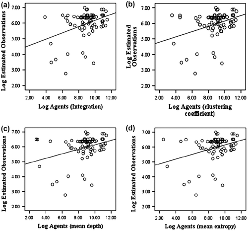
Table 1. VGA based agents and correlation coefficients (n = 75).
The linear associations between vision-based agents and estimated bicycle observation data are displayed in Figure and Table . The agent rules in this scenario are founded on visionary clues obtained from occluded edges. In general, positive relationships were found among bicyclist observations and bicycle agents. A statistically significant relationship was not found between bicycle agents designed to move toward anyrandom occlusion (any occlusion) and observation data (Figure (a)). The insignificant result indicates that bicyclists may not focus on random edges while traversing the environment. The strongest statistically significant relationship was found between vision-based bicycle agents designed to seek the furthest occlusion and bicyclist observations (R2 = .300, p-value = .009) (Table , Figure (c)). This result is supported by Turner (Citation2007), who found that pedestrian movement was strongly correlated to furthest occlusions. In this research, bicyclists may have utilized distant occlusions such as building corners or other types of visible objects such as traffic control devices for wayfinding. In an urban environment where there are many occlusions, the furthest object will likely be the focus. Therefore, urban designs that promote bicycling should include bicycle facilities such as bicycle signage or bicycle lanes that are visible from afar. A positive correlation coefficient was also found between globally directed bicycle agents and observation data (R2 = .332, p-value = .004) (Table , Figure (b)). The agents in this iteration relied on elementary vision in a true exploratory traveling motivation. This result supports prior evidence that human movement is nonlinear and should be treated as such (Andriotti, Citation2006). More importantly, the association found in this research may shed light on the needs of bicyclists unfamiliar with the area. For instance, new bicyclists to an area may require wayfinding points (i.e. occlusions) throughout the environment to navigate successfully. Table also indicates that bicycle agents guided by occluding radials weighted by length, angularity, or length and angularity exhibited significant p-values and positive associations to observed bicycle counts (Figures (d–f)). Bicyclist agents weighted by the angles (i.e. angular deviation from the current position) was moderately positive and statistically significant in this study (R2 = .283, p-value = .014). The result appears contradictory to past research that has shown bicyclists tend to minimizing street designs with increased angularity (Raford et al., Citation2007). Bicyclists in this example appeared to choose occlusions that contained the greatest amount of angular deviation. This finding may be a result of elevated bicycling in this area or the sheer number of turns needed to traverse the gridded street pattern. The significant statistical associations found between agents and observation data indicate that bicyclists capitalize on occluded points that allow them to maintain a linear heading by focusing on occlusions that are in the distance. Therefore, potential bicycle travel corridors should be designed to maintain linearity and contain visible infrastructural elements that satisfy a bicyclist’s wayfinding need. For example, a bicycle shelter positioned along a linear route could satisfy such a need by providing a place for refuge and allow for route decisions to be made.
Figure 5. Correlation scatterplots for vision based bicyclist agents.
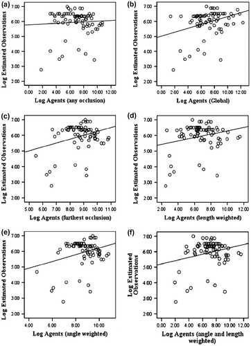
Table 2. Vision based agent correlation coefficients (n = 75).
Conclusion
Promoting bicycling through efficient design holds great promise in reducing automobile orientated externalities and in promoting public health. To meet these goals, a greater understanding of the spatial influence on bicycling wayfinding is needed. This research implemented a progressive bottom-up modeling approach to investigate the importance of vision and urban morphology on bicycle wayfinding. A bicycle specific ABM was implemented to test its usefulness in predicting bicyclist movements using vision and built form rules. The modeling approach used in this study has shown that a simplistic ABM can be utilized with moderate success in shedding light on bicycle movement patterns. With this information, urban planners in other cities may successfully design bicycle-friendly environments.
In this paper, a space syntax ABM was utilized to demonstrate that individual bicycle wayfinding behavior can be simulated in a virtual syntactical environment; further substantiating the important link among vision, urban form, and bicycling. Three groups of bicycle agents were developed in this research. Each agent group was guided by differing rules. The success of the bicycle agents was validated by comparing them to estimated bicycle observation data. The first group of agents were directed by urban morphology (VGA) measures; these were founded on Gibson’s (Citation1979) theory of ecological perception and Hillier’s (Citation1993) theory of natural movement. The second groups of agents were guided by vision-based metrics. These metrics address the visual acknowledgment of occluding radials. In addition, undirected and unsighted global bicyclist agents were incorporated in this research to investigate the degree of correspondence between true exploratory bicycle agent behavior and observation data. A correlation analysis was conducted to test the strength of association between the bicycle agents and observation data.
Bicyclist agents directed by urban form-based rules displayed the largest correlation to observation data. For example, the analysis on agents guided by urban form factors demonstrated that bicyclists gravitated toward well-connected, visually enhanced, and visually equitable spaces. The significant correlation coefficients between observational data and bicyclist agents ruled by the furthest occluding point signify that routes which contain extended visible landmarks may contribute to successful bicyclist wayfinding. From a practical standpoint, traversable bicyclist right-of-ways that include a multitude of visual edges and points, such as street level architecture, bicyclist signage, and properly scaled buildings that do not hinder visibility may encourage bicycle travel.
The research has several limitations. First, it should be noted that the ABM used in this research is not a complete model. The ABM was relatively homogenous in that the agents were designed using simplistic vision and built form rules; it did not incorporate socio-demographic factors, travel destinations, or bicyclist safety factors. Excluding these factors may have contributed to the moderate correlations found in this research. In terms of bicyclist safety, previous research has found that bicycling accidents are largely attributed to roadway conditions such as higher traffic speeds, reduced roadway width, and increased daily traffic (Landis et al., Citation1997). Therefore, future bicycle ABM research should strive to include these variables when designing ABMs to forecast bicycling. For instance, weighting the traversable roads by average daily traffic may produce a more realistic transportation condition thus increasing the explanatory power of the model. The correlation coefficients in this study had a moderate strength. One reason for the moderate correlation coefficients may be the small sample size. Therefore, future research should include a larger set of observational data. Additional data could be collected via GPS devices or from bicycle route traces collected from a sample of people in the area. For example, a study conducted by Raford et al. (Citation2005) collected 423 cyclist traces and compared them to bicycle agents to compute bicyclist shortest path routes. An additional drawback of this study was the ABM specification related to bicyclist movement. The bicyclists in this research were neither directed toward any particular destination nor were they allowed to interact with other agents thus potentially contributing to the moderate correlation coefficients. The current research could be extended by utilizing more advanced ABMs such as REPAST or NetLogo. For example, pedestrian agents were successfully directed toward a particular destination using ArcGIS and NetLogo in a study by Jiang and Jia (Citation2011). Implementing directed agents in this research would make it more comparable to existing traffic models that incorporate origin-destination pairs.
The finding that bicyclist wayfinding success hinges on microscopic visual clues and the built form factors provides further recommendations for practitioners on how to increase bicycling in their area. In particular, the results support the need for bicycle corridors that are wide, offer high visibility, contain reduced stops, are visually accessibility, and possess distant bicycle specific wayfinding features. With this information, practitioners will be better prepared to enact policies and plans that successfully encourage bicycling.
References
- Allen, G. (1999). Cognitive abilities in the service of wayfinding: A functional approach. The Professional Geographer, 51, 555–561.10.1111/0033-0124.00192
- Andriotti, G. K. F. K. (2006). Agent-based simulation versus econometrics – From macro to microscopic approaches to route choice simulation. Lecture notes in computer Science, 4196, 61–72.10.1007/11872283
- Aultman-Hall, L., Hall, F. L., & Baetz, B. B. (1997). Analysis of bicycle commuter routes using geographic information systems: Implications for bicycle planning. Transportation Research Record, 1578, 102–110.10.3141/1578-13
- Axelrod, R. (1997). Advancing the art of simulation in the social sciences. Complexity, 3, 16–22.10.1002/(ISSN)1099-0526
- Barnes, G., & Krizek, K. (2005). Estimating bicycling demand. Transportation Research Record, 1939, 45–51.10.3141/1939-06
- Batty, M., Desyllas, J., & Duxbury, E. (2003). The discrete dynamics of small-scale spatial events: Agent-based models of mobility in carnivals and street parades. International Journal of Geographical Information Science, 17, 673–697.10.1080/1365881031000135474
- Benedikt, M. L. (1979). To take hold of space: Isovists and isovist fields. Environment and Planning B, 6, 47–65.10.1068/b060047
- Black, W. R. (2010). Sustainable transportation: Problems and solutions. New York, NY: The Guilford Press.
- Bonabeau, E. (2002). Predicting the unpredictable. Harvard Business Review, 80, 109–116.
- Cervero, R., & Duncan, M. (2003). Walking, bicycling, and urban landscapes: Evidence from the San Francisco bay area. American Journal of Public Health, 93, 1478–1483.10.2105/AJPH.93.9.1478
- Cervero, R., & Kockelman, K. (1997). Travel demand and the 3Ds: Density, diversity, and design. Transportation Research Part D, 2, 199–219.10.1016/S1361-9209(97)00009-6
- Chen, X., Meaker, J. W., & Zhan, F. B. (2006). Agent-based modeling and analysis of hurricane evacuation procedures for the Florida keys. Natural Hazards, 38, 321–338.10.1007/s11069-005-0263-0
- Clarke, K. C. (1997). Getting started with geographic information systems. Upper Saddle River, NJ: Prentice Hall.
- Colditz, G. A. (1999). Economic costs of obesity and inactivity. Medicine & Science in Sports and Exercise, 31, S663.10.1097/00005768-199911001-00026
- Dalton, R. C. (2003). The secret is to follow your nose: Route path selection and angularity. Environment and Behavior, 35, 107–131.
- Desyllas, J., & Duxbury, E. (2001). Axial maps and visibility graph analysis. Paper presented at the Proceedings of the 3rd International Symposium on Space Syntax, Georgia Institute of Technology, Atlanta, GA.
- Dill, J. (2009). Bicycling for transportation and health: The role of infrastructure. Journal of Public Health Policy, 30, S95–S110.10.1057/jphp.2008.56
- Frank, L., Bradley, M., Kavage, S., Chapman, J., & Lawton, T. K. (2008). Urban form, travel time, and cost relationships with tour complexity and mode choice. Transportation, 35, 37–54.
- Frank, L., Engelke, P. O., & Schmid, T. L. (2003). Health and community design: The impact of the built environment on physical activity. Washington, DC: Island Press.
- Frank, L. D., & Pivo, G. (1995). Impacts of mixed use and density on utilization of three modes of travel: Single-occupant vehicle, transit, and walking. Transportation Research Record, 1466, 44–52.
- Franz, G., & Wiener, J. M. (2008). From space syntax to space semantics: A behaviorally and perceptually oriented methodology for the efficient description of the geometry and topology of environments. Environment and Planning B: Planning and Design, 35, 574–592.10.1068/b33050
- Gatersleben, B., & Haddadb, H. (2010). Who is the typical bicyclist? Transportation Research Part F: Traffic Psychology and Behaviour, 13, 41–48.10.1016/j.trf.2009.10.003
- Gibson, J. J. (1979). The ecological approach to perception. Boston, MA: Houghton Mifflin.
- Golledge, R. G. (Ed.). (1999). Human wayfinding and cognitive maps. Baltimore, MD: The Johns Hopkins University Press.
- Groff, E. R. (2007). ‘Situating’ simulation to model human spatio–temporal interactions: An example using crime events. Transactions in GIS, 11, 507–530.10.1111/tgis.2007.11.issue-4
- Handy, S., Xing, Y., & Buehler, T. J. (2010). Factors associated with bicycle ownership and use: A study of six small US cities. Transportation, 37, 967–985.10.1007/s11116-010-9269-x
- Heinen, E., Wee, B. V., & Maat, K. (2010). Commuting by bicycle: An overview of the literature. Transport Reviews, 30, 59–96.10.1080/01441640903187001
- Hillier, B. (2006). Studying cities to learn about minds: How geometric intuitions shape urban space and make it work. In C. Hoelscher, A. Turner, & R. Conroy-Dalton (Eds.), Space syntax and spatial cognition – Proceedings of the workshop in Bremen (pp. 11–31). Bremen: Springer.
- Hillier, B., Penn, A., Hanson, J., Grajewski, T., & Xu, J. (1993). Natural movement: Or, configuration and attraction in urban pedestrian movement. Environment and Planning B: Planning and Design, 20, 29–66.10.1068/b200029
- Hillier, B., & Vaughan, L. (2007). The city as one thing. Progress in Planning, 67, 205–230.
- Jackson, J., Forest, B., & Sengupta, R. (2008). Agent-based simulation of urban residential dynamics and land rent change in a gentrifying area of Boston. Transactions in GIS, 12, 475–491.10.1111/tgis.2008.12.issue-4
- Jiang, B., & Jia, T. (2011). Agent-based simulation of human movement shaped by the underlying street structure. International Journal of Geographical Information Science, 25, 51–64.
- Katz, R. (1995). Modeling bicycle demand as a mainstream transportation planning function. Transportation Research Record, 1502, 22–28.
- Komanoff, C., & Roelofs, C. (1993). The environmental benefits of bicycling and walking. In FHWA (Ed.), National bicycling and walking study case study #15 (p. 15). Washington, DC: US Department of Transportation, Federal Highway Administration.
- Landis, B. W., Vattikuti, V. R., & Brannick, M. T. (1997). Real-time human perceptions: Toward a bicycle level of service. Transportation Research Record, 1578, 119–126.10.3141/1578-15
- Lee, D. (1986). An efficient transportation and land use system. Cambridge, MA: Transportation Systems Center.
- Litman, T. (1994). Bicycling and transportation demand management. Transportation Research Record, 1441, 134–140.
- McCahill, C., & Garrick, N. W. (2008). The applicability of space syntax to bicycle facility planning. Transportation Research Record: Journal of the Transportation Research Board, 2074, 46–51.10.3141/2074-06
- McDonald, C. H., & Burns, E. K. (2001). Cycling to work in phoenix: Route choice, travel behavior, and commuter characteristics. Paper presented at the Transportation Research Board Annual Meeting, Washington, DC.
- Mottram, C., Conroy, R., & Turner, A. (1999). Virtual beings: Emergence of population level movement behaviors from individual rule sets. Paper presented at the Proceedings of the 2nd International Symposium on Space Syntax, Universidad de Brasil, Brasilia.
- Najlis, R., & North, M. J. (2004). Repast for GIS. Paper presented at the Proceedings of Agent 2004: Social Dynamics: Interaction, Reflexivity and Emergence, Chicago, IL.
- Newman, P., & Kenworthy, J. R. (1999). Sustainability and cities: Overcoming automobile dependence. Washington, DC: Island Press.
- Parkin, J., Ryley, T., & Jones, T. (2007). On barriers to cycling: An exploration of quantitative analysis. In P. R. D. Horton & P. Cox (Eds.), Cycling and Society (pp. 67–82). London: Ashgate.
- Penn, A., & Turner, A. (2002). Space syntax based agent simulation. In M. Schreckenberg & S. D. Sharma (Eds.), Pedestrian and evacuation dynamics (Vol. XIX, pp. 99–114). Berlin: Springer.
- Penn, A., & Turner, A. (2003). Space layout affects search efficiency for agents with vision. Paper presented at the Proceedings 4th International Space Syntax Symposium, London.
- Peponis, J., Zimring, C., & Choi, Y. K. (1990). Finding the building in wayfinding. Environment & Behavior, 22, 555–590.
- Porter, C., Suhrbier, J., & Schwartz, W. L. (1999). Forecasting bicycle and pedestrian travel: State of the practice and research needs. Transportation Research Record, 1674, 94–101.10.3141/1674-13
- Pratt, M., Macera, C. A., & Blanton, C. (1999). Levels of physical activity and inactivity in children and adults in the United States: Current evidence and research issues. Medicine & Science in Sports and Exercise, 31, S526–533.10.1097/00005768-199911001-00007
- Pucher, J., Dill, J., & Handy, S. (2010). Infrastructure, programs, and policies to increase bicycling: An international review. Preventative Medicine, 50, 106–125.
- Raford, N., Chiaradia, A., & Gil, J. (2005). Critical mass: Emergent cyclist route choice in central London. In The 5th Space Syntax Symposium, TU Delft, Holland.
- Raford, N., Chiaradia, A. J. F., & Gil, J. (2007). Space syntax: The role of urban form in cyclist route choice in central London. Paper presented at the 86th Annual Meeting of the Transportation Research Board, Washington, DC.
- Raford, N., & Ragland, D. (2004). Space syntax: Innovative pedestrian volume modeling tool for pedestrian safety. Transportation Research Record, 1878, 66–74.10.3141/1878-09
- Raubal, M., & Winter, S. (2002). Enriching wayfinding instructions with local landmarks. In E. Egenhofer & D. Mark (Eds.), Geographic information science – second international conference, GIScience (Vol. 2478, pp. 243–259). Berlin: Springer.
- Rodrı́guez, D. A., & Joo, J. (2004). The relationship between non-motorized mode choice and the local physical environment. Transportation Research Part D: Transport and Environment, 9, 151–173.10.1016/j.trd.2003.11.001
- Ronald, N., Sterling, L., & Kirley, M. (2009). An agent-based approach to modelling pedestrian behaviour. International Journal of Simulation, 8, 25–38.
- Saneinejad, S., Roorda, M. J., & Kennedy, C. (2012). Modelling the impact of weather conditions on active transportation travel behaviour. Transportation Research Part D: Transport and Environment, 17, 129–137.10.1016/j.trd.2011.09.005
- Schaefer, B. (2008). Case statement for the Madison, Wisconsin metropolitan area rails-to-trails conservancy 2010 campaign for active transportation. Madison, WI: Madison Area Transportation Planning Board (pp. 1–13).
- Torrens, P. M. (2012). Moving agent pedestrians through space and time. Annals of the Association of American Geographers, 102, 35–66.10.1080/00045608.2011.595658
- Turner, A. (2000). Depthmap, Version 7: From Isovist analysis to generic spatial network analysis. London: University College London.
- Turner, A. (2001). Angular analysis. In J. Peponis, J. Wineman, & S. Bafna (Eds.), Proceedings of the 3rd international symposium on space syntax Georgia Institute of Technology (pp. 30.1–30.11). Atlanta, GA: Georgia Institute of Technology.
- Turner, A. (2003). Analysing the visual dynamics of spatial morphology. Environment and Planning B: Planning and Design, 30, 657–676.10.1068/b12962
- Turner, A. (2004). Depthmap 4 – A researcher’s handbook. London: Bartlett School of Graduate Studies, UCL (pp. 58).
- Turner, A. (2007). The ingredients of an exosomatic cognitive map: Isovists, agents and axial lines? In C. Hölscher, R. C. Dalton, & A. Turner (Eds.), Space syntax and spatial cognition: Proceedings of the workshop held in Bremen, 24th September 2006 (pp. 163–180). Bremen: Universität Bremen.
- Turner, A., & Penn, A. (1999). Making isovists syntactic: Isovist integration analysis. In F. Holanda (Ed.), Proceedings, second international symposium on space syntax (Vol. 1, p. 08). Brasillia: Universidade de Brasillia.
- Watts, D. J., & Strogatz, S. H. (1998). Collective dynamics of ‘small-world’ networks. Nature, 393, 440–442.10.1038/30918
- Winters, M., Brauer, M., Setton, E. M., & Teschke, K. (2010). Built environment influences on healthy transportation choices: Bicycling versus driving. Journal of Urban Health, 87, 969–993.10.1007/s11524-010-9509-6
- Xia, J. C., Arrowsmith, C., Jackson, M., & Cartwright, W. (2008). The wayfinding process relationships between decision-making and landmark utility. Tourism Management, 29, 445–457.10.1016/j.tourman.2007.05.010