
Abstract
Landslides are one of the most substantial damaging and recurrent disasters in the hilly areas of Bangladesh. In the last decades, devastating landslides have repeatedly hit the hilly regions of the country, typically due to climate change along with other anthropogenic causes such as high population density, unplanned land use, and rampant hill cutting. However, there is a lack of an official database to analyze the trends of the landslide disaster in Bangladesh. In this vein, this paper compiled a catalog of 204 reported landslides in Bangladesh that caused 727 deaths and 1017 injuries during the period 2000–2018. The average number of annual landslides is 19, with a 4% yearly growth rate, which results in 38 fatalities and 54 injuries yearly on average. Using data from three national and two regional newspapers, the study finds that monsoon summer is the most damaging season and 83% of landslides are primarily triggered by heavy rainfall. A Hot Spot Analysis tool (Getis-Ord- Gi* algorithm) was used to identify the spatial concentration of high and low landslide affected areas in Bangladesh. Of 64 districts in the country, eight were exposed by landslide episodes, five were recognized as profoundly affected. Moreover, three sub-districts (Chattogram City Corporation, Ukhiya and Teknaf) have been identified as hot spot areas. Finally, the study will assist academicians for continuing risk studies through understanding the trends of landslide related causalities; policymakers for formulating suitable policies considering the high landslide affected areas; consequently, help local communities to protect their life and properties through raising awareness.
PUBLIC INTEREST STATEMENT
The paper contributes to the discourse on the geographic variations of landslide incidence in Bangladesh through preparing a landslide catalog for 19 years of period. Similar to other developing countries, Bangladesh lacks an official inventory of landslides underestimating the factual settings of landslide vulnerability in hilly regions of the country. Hence, the paper identifies the landslide-prone, highest affected, along with landslide hotspot of the hilly regions of Bangladesh. It shows that the annual number of fatal landslides is increasing unpredictably as new places are exposing every year with more landslides that can be useful to analyze the landslide behaviors in the newly emerging industrialized landslide-prone countries. However, there is a paucity of comprehensive and well-integrated response by the Government that required a sustainable landslide hazard management emphasizing on the social settings of landslide-prone areas, the socio-economic vulnerability as well as the availability of resources and capacity.
1. Introduction
The Intergovernmental Panel on Climate Change (IPCC) published a special report on “Managing the Risks of Extreme Events and Disasters to Advance Climate Change Adaptation” that emphasized on the inevitability for Risk Management Strategies with a prediction of an increase of the mean temperature as well as a change in rainfall patterns in the near future, leading to potential increased shallow landslides (Nadim et al., Citation2014). Prior to that, reducing the consequences (loss of life and property) from natural and human-induced disasters, including landslides, is one of the prime objectives of GEOSS, the Global Earth Observation System of Systems (2005–2015), recently created by the Group on Earth Observations (GEO). Therefore, it is expected, due to the numerous global change scenarios, more people will be exposed to landslide hazards. Considering that fact, UN International Strategy for Disaster Reduction (UNISDR) encourages local authorities to identify the landslide risk and vulnerabilities to build disaster resilient communities through promoting increased awareness regarding the importance of disaster reduction as an integral part of sustainable development (UNISDR, U., Citation2015).
Landslides are a global phenomenon that plays a significant role in the landscape’s evolution (Parker et al., Citation2011). However, in many areas, they also pose a severe threat to localized people directly, mainly influenced by different phenomena (Alexander, Citation2005). In recent years, it is already apparent from prior research that the location, abundance, activity, frequency of landslides as well as the social and economic consequences of landslide hazards are increasing with time (Dai et al., Citation2002; Guzzetti, Citation2000; Haque et al., Citation2019; Keefer & Larsen, Citation2007; D. N. Petley et al., Citation2005; Schuster & Highland, Citation2001) and more people are exposing to landslide risk (Gariano & Guzzetti, Citation2016; Sidle & Ochiai, Citation2006). Recent studies have ranked landslide as the 4th biggest deadly among natural disasters, after flood, storms, and earthquakes (Lacasse et al., Citation2010).
However, in many countries, landslide related casualties and economic losses may be higher than as commonly documented, and those may exceed all other losses due to natural disasters, i.e., earthquakes, floods, cyclones, hurricanes, etc. (Anderson et al., Citation2011; Guzzetti et al., Citation1999; Schuster, Citation1996) if appropriately documented. Additionally, there is widespread recognition that the overall consequence of landslides is usually underestimated (Kjekstad & Highland, Citation2009; D. Petley, Citation2012) as landslide data are not systematically available (Corominas et al., Citation2013; D. N. Petley, Citation2010) unlike other natural disasters; and landslide related casualties are often recorded under the label of triggering events, which is more large events such as flood, hurricanes, or tropical storms, earthquake, etc. (Froude & Petley, Citation2018; UNDP, Citation2004). Most of the cases, conversely, exact landslide reporting is hindered by the comparatively small scale on which they occur, and that is un-recognized in most natural disaster’s registers (Holcombe & Anderson, Citation2010). Therefore, landslide database is essential for understanding the trends and consequences of previous landslide events which will assist in targeting limited resources in the most appropriate technique and in improving the identification of areas and people at risk of landslides.
There are some former works based on global landslide catalog; for example, D. B. Kirschbaum et al. (Citation2010) prepared a rainfall-induced landslide catalog for several years at global scale; D. Petley (Citation2012) compiled 2620 fatal landslides with the fatalities of 32,322 for the time 2004–2010; D. Kirschbaum et al. (Citation2015) conducted spatial and temporal analysis of 5741 global landslide point during 2007–2013; Dowling and Santi (Citation2014) gathered 213 debris flow that has caused 77,779 fatalities in the period 1950–2011; Froude and Petley (Citation2018) compiled a non-seismic 4862 landslides that occurred from 2004 to 2016 which causes 55997 deaths, and U. Haque et al. (Citation2019) compiled 3876 landslides for 20 years that resulted in 163,658 deaths along with 11,689 injuries in 128 countries. However, comprehensive landslide databases are also available for a few countries or regions. Chau et al. (Citation2004) collected information on 1448 landslide data between 1984 and 1998 for Hong Kong and analyzed the daily and seasonal distribution of landslides. Wen et al. (Citation2005), working in China, compiled a database of 400 fatal landslides between 2001 and 2004 that have caused at least 3000 deaths and missing persons. D. N. Petley et al. (Citation2007) compiled a database of 397 deadly landslides in Nepal that results in 2179 fatalities for the period 1978–2005. Hilker et al. (Citation2009) gathered a landslide damage database applied for the 36 years 1972–2007, and Badoux et al. (Citation2016) analyzed the database of natural hazard induced fatalities between 1946 and 2015 in Switzerland. Pereira et al. (Citation2014) used a catalog of 628 landslide events in Northern Portugal that have caused 136 deaths, 173 injured and left 460 people homeless for the period 1900–2010. Sepúlveda and Petley (Citation2015) counted 11631 deaths caused by 611 fatal landslides in Latin America and the Caribbean from 2004 to 2013. Later, a regional landslides database was compiled for 27 European countries, which reports 1370 deaths and 784 injuries due to 476 landslides from 1995 to 2014 (Haque et al., Citation2016). In 2018, a national database of 84 fatal landslides prepared for the Canada lists information on 545 fatalities from 1840 to 1996 (Evans, Citation2018). Besides, other landslide catalogs were also compiled for New Zealand (Benn, Citation2005), Germany (Benn, Citation2005; Pennington et al., Citation2015), Italy (Guzzetti, Citation2000; Salvati et al., Citation2018) that have emphasized on fatal landslides and related consequences. Therefore, it is evident from the literature that prior landslide databases are mostly compiled in developed countries.
Additionally, Asia is the most landslide-prone continent (Froude & Petley, Citation2018; Li et al., Citation2010; D. Petley, Citation2012) and rainfall-induced landslide events are increasing day by day in South Asia due to the strength of summer monsoon (Haque et al., Citation2019). For example, Sen Roy and Balling (Citation2004) assembled daily precipitation records throughout the India for 129 stations during 1910–2000 to prepare daily precipitation indices; and the results identified 61% of time series with an upward trend of rainfall. However, very few authors compiled landslide databases in Asia based on their consequences in terms of fatalities and injuries. For instance, Franks (Citation1999) analyzed some rainfall-induced landslides during the period 1945–1995 to understand the potential hazards from natural terrain landslides to downslope development on Lantau Island in Hong Kong. Later, a rainfall-induced landslide database was prepared for Hong Kong between 1984 and 1997 that mainly emphasized on the relationships between rainfall and the number of landslides (Dai & Lee, Citation2001). Moreover, Zhou et al. (Citation2002) analyzed the spatial relationship between landslides and their causative factors for 903 landslides that occurred in 1993 on Lantau Island, Hong Kong. Another landslide database was prepared based on 172 rainfall-induced landslides in Taiwan during 2006 − 2012 to compare the landslide size with rainfall conditions (Chen et al., Citation2017). Apart from these, Gao et al. (Citation2018) studied a large landslide inventory of 19,763 records from 1984 to 2013 to assess the magnitudes and triggering rainfall thresholds of the open hillslope landslides as well as channelized debris flows in Hong Kong. More recently, Bera et al. (Citation2019) analyzed an inventory of 39 landslide events to evaluate the effectiveness of landslide susceptibility as well as to generate a Landside Susceptibility Index (LSI) map in part of Western Ghat, India. However, there is a lack of study emphasized on the consequences of landslide episodes in terms of fatality, injury and damages. Although, the Asian Disaster Reduction Centre (ADRC) has started a new disaster database worldwide, which shows that about 96 landslides and mudslide occurred in Asia, among them 12 in South Asia (GLIDE, Citation2019); however, the overall landslide-induced casualties are also underestimated in this database as it follows the EM-DAT criteria. Hence, recent estimations of landslide casualties (direct and indirect losses) underreported the extent of their impacts unconsciously due to the complications of viable and informative landslide database (D. B. Kirschbaum et al., Citation2010), especially in South Asian countries. In most cases, there is an absence of official landslide specific database.
Comprehending the indispensable need for landslide risk reduction, the Asian Disaster Preparedness Center (ADPC) introduces an umbrella program namely Regional Capacity Enhancement for Landslide Impact Mitigation (RECLAIM), along with a pilot project IPL 180 aims at developing a city-level landslide hazard risk-management strategy in Bangladesh so that other vulnerable cities in Asia will be able to replicate effective practices for reducing future losses (Towashiraporn & Arambepola, Citation2017). In this connection, sustainable landslide risk reduction strategies are essential for all the landslide-prone countries, including Bangladesh, that increasing interest for country-specific or national landslide databases.
However, like many other developing countries, in Bangladesh, a systematic official landslide database is not developed yet. Although the Department of Disaster Management (DDM) of the Ministry of Disaster and Relief of Bangladesh records landslide events, the records are not regularly updated and also unavailable online. However, a few researchers put efforts into preparing landslide inventories based on satellite images and aerial photographs that mostly focused on landslide locations with their physical characteristics. Most importantly, existing lists were organized for the major cities of the Chattogram Hilly Area (CHA) and highly focused on the landslide mapping (CDMP-II, Citation2012; Ahmed, Citation2015). For example, the Comprehensive Disaster Management Programme of the Ministry of Disaster and Relief of Bangladesh provided a detailed inventory of 77 landslide locations of Cox’s Bazar and Teknaf municipalities (CDMP-II, Citation2012). Later, another effort was made to compile landslide inventories for the Chattogram Metropolitan Area (CMA) that identified 57 landslide events (Rahman et al., Citation2016). Besides, a landslide susceptibility map was also prepared for the Chattogram City Corporation by using bivariate and multivariate techniques (Ahmed & Dewan, Citation2017). More recently, a distinct landslide inventory was developed by combining the previous catalogs for the whole CHA from 2001 to 2017 and identified 730 landslide episodes (Rabby & Li, Citation2018).
However, all the existing landslide inventories emphasized the landslide mechanisms, classifications, and their mapping. Therefore, still, there is no landslide database for the whole country that focused on the causalities. Thus, it is indispensable to construct a national landslide database as a platform for developing the area-specific landslide risk reduction approach that can help to combine the information from numerous sources across the country consistently as well as can assists in understanding the landslide trends in Bangladesh. This study is mainly focused on fatalities and injuries due to landslide disasters in Bangladesh from 2000 to 2018 at Upazila (sub-district) level.
Therefore, this paper presents a national database for Bangladesh, based on the printed newspaper, during 2000–2018 that emphasized mainly on the spatial and temporal distribution of the casualties (fatality and injury) due to landslide disaster. Additionally, the probable causes of the identified trends of landslide casualties were also discussed by comparing the data with other countries. Finally, a hot spot analysis has been performed by the Spatial Statistics Hot Spot Analysis tools (Getis-Ord- Gi* algorithm) to identify the statistically significant geographical concentration of high and low affected areas in Bangladesh. The database can support the researchers, policymakers as well as practitioners for determining the extent of occurrence along with consequences of landslides in Bangladesh, in South Asia, and Asia as well.
2. Materials and methods
2.1. Study area
Bangladesh is a south Asian, densely-populated, low-lying and riverine country with a surface area of 147,610 km2. The physiography of Bangladesh is typically categorized by a vast deltaic plain (80% of the total land) with a low hilly area in the north-east and south-east region (as shown in Figure ). Landslides are recurrent phenomena in the hilly and tract areas (only 18% of the total land), especially in the south-eastern part of Bangladesh (Ahmed, Citation2014; Alam et al., Citation2005; I. Khan, Citation2008) mainly occurring during the rainy season (B Ahmed & Rubel, Citation2013; Y. A. Khan et al., Citation2012). The north-east region consists of several hills and hillocks (tilas) and mostly noticeable along with the Sylhet city up to Srimangal and Moulvibazar. The elevation varies from 60 to 150 meters for hills, and the height of hillocks (tilas) ranges from 30 to 90 meters (Islam et al., Citation2006).
Figure 1. Location of the study area with elevation
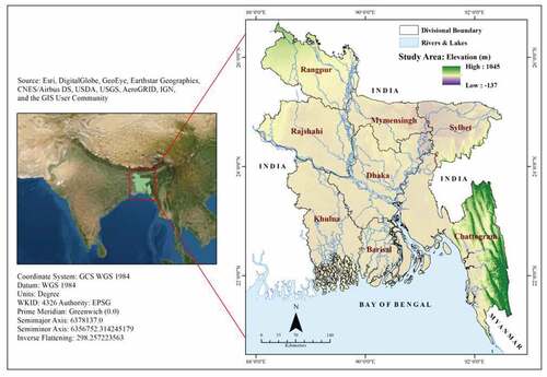
However, the extensive hilly areas are situated in the south-eastern part of the country known as Chattogram Hill Tracts region- CHT (one-tenth of the total area) comprised of three districts of Bangladesh (Rangamati, Khagrachari, and Bandarban). The elevation of this region varies from 600 to 900 meters above sea level. There is a chain of narrow coastal hills with a height ranging from below 200 to 350 meters above sea level, divided into Chattogram and Cox’s Bazar district. The areas are mostly developed in the Tertiary period of the geological timescale with complex soil composition. The hilly soils are mainly yellowish-brown to reddish-brown loams that composed of unconsolidated sedimentary rocks such as sandstone, siltstone, shale, and conglomerate with local unconformities (Y. A. Khan et al., Citation2012; Rashid, Citation1991). Moreover, the hills are mainly triggered by tertiary and quaternary sediments that have been folded, faulted, and uplifted, then divided by rivers and streams (Brammer, Citation1996). Hence, the geological structures and soil are unstable, weak, quickly saturated with water, and also have steep slopes making the hills of Bangladesh highly susceptible to landslides (Sarker & Rashid, Citation2013). The bedrock and soil structure (consisting of hard red clay mixed with fine sand) of these hills are precarious with characteristics of a steep slope, high permeability, and erodibility (Ahmed, Citation2014) that alter these regions extremely susceptible to a landslide (Mahmood & Khan, Citation2010). Furthermore, due to climate change, in recent years the country is experiencing extremely high rainfall intensity within a shorter period often causing landslide (Mutizwa-Mangiza et al., Citation2011), which is increasing the vulnerability specifically in the unconsolidated rocks and steeper slopes areas (Mahmood & Khan, Citation2010). Apart from these, rapid urbanization, unsustainable land use, mining activities, alteration of the hills through hill cutting, rapid deforestation and traditional shifting farming practices are aggravating the landslide vulnerability in the hilly regions of Bangladesh (Mia et al., Citation2016).
2.2. Sources of data for landslide database
The study has compiled a landslide database called “Bangladesh Landslide Database (BDLS-DAT)” during 2000–2018, which includes the immediate triggering mechanisms and casualties (i.e., number of fatalities and injuries) regardless of size, types and absolute location. The data was accumulated from numerous sources’ for detecting all the previously reported landslide events for preparing a complete national landslide database for Bangladesh (Figure ). Firstly, three leading national daily newspapers (1 in English and 2 in Bengali) (i.e., The Daily Star, The Prothom Alo, and The Ittefaq) and two regional or local Bengali daily newspapers (Amader Sylhet and Shuprobhat) were scanned as a primary source for searching the prior landslide events from 1 January 2000 to 31st November 2018. As casualties resulting from landslides are often reported under its triggering factors, news reports on related phenomena (such as flash flood, flood, hill cutting, mining), which can cause landslides, also scanned. The data collection period, from selected newspapers, was 3rd August 2018 to 20th December 2018. The Newspaper was selected based on their acceptability within the country (in terms of circulation) as well as the availability of their printed version for the chosen period in the Newspaper sections of the Central Library of the University of Dhaka.
Figure 2. Search and formation techniques of the Bangladesh landslides database (BDLS-DAT), 2000–2018
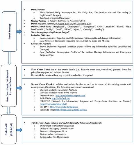
Previous landslide databases mostly depend on only online news articles, which creates uncertainties in obtaining data for more extended periods as those usually deactivated after a certain period. Moreover, newspaper archives are also only available for 5–8 years, which makes challenges for accumulating landslide events retrospectively for such a long period. Additionally, there are some websites which work as a supplementary resource for updating the global and regional landslide database through providing the web links to media reports related with landslide events (D. B. Kirschbaum et al., Citation2010). However, most of them are region or country or continent specific; and importantly, these websites mostly highlighted the landslide episodes occurred in the developed countries. Apart from the websites, there are some other hazard databases (not landslide specific) that also published landslide episodes as a secondary hazard (for example, http://earthquake-report.com/2013/06/01/worldwide-landslide-report/) or with their distinct criteria for reporting landslide episodes. For instance, the EM-DAT database typically reported the landslide events with at least ten fatalities and at least 100 injuries along with an emergency declaration by the affected country that needs international assistance to overcome this situation, resulting in underestimation of landslide impacts (D. Petley, Citation2012). As a result, a web-based landslide database creates some uncertainties to identify all landslide episodes (specifically small events and events in remote areas) and underrepresent the number of landslides as well as its casualties. Therefore, the study selected printed newspaper as a primary source of data collection. Apart from these, some essential web sources were also considered (for example, yearly/monthly disaster reports published by the Disaster Forum and NIRAPAD- Network for Information, Response and Preparedness Activities on Disaster, https://www.nirapad.org.bd/) for additional cross-checking, validating and updating the data, if required.
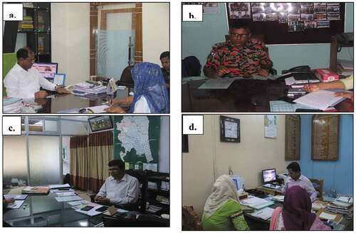
Finally, the prepared database was further cross-checked, verified, and updated from the responsible authorities such as Department of Disaster Management, Office of the Deputy Commissioner, District civil surgeon offices, District police headquarters, etc. to overcome the missing information and needless repetition. Besides, the researcher conducted an informal interview with each DRROs (Disaster Relief and Rehabilitation Officer) in the Office of the Deputy Commissioner through a field visit to verify the information (Figure ).
Figure 3. Informal interviews with responsible authorities during field visit at (a) Chattogram City Corporation; (b) Cox’s Bazar Sadar; (c) Bandarban Sadar; and (d) Rangamati Sadar, 2019
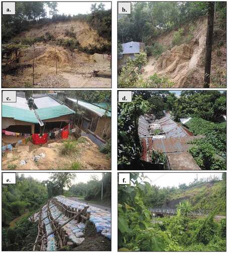
During this field visit, the researcher also visited some sample sites of previous landslide locations and talked with the local people as well as officials to verify the causalities due to that particular landslide event (Figure ). Therefore, each of the recorded landslide events was cross-checked and validated in those processes. Along with this, the monthly precipitation data from 10 stations, located in landslide-prone districts of Bangladesh, during 2000–2018 was also used and analyzed in this study, provided by the Bangladesh Meteorological Department (BMD, Citation2019).
Figure 4. Different landslide locations during field visit, (a) South Mithaichari Union, Chainda, Ramu, Cox’s Bazar, 25 July 2017; (b) Joyariyanala Union, Mitharchara Village, Ramu, Cox’s Bazar, 26 June 2015; (c) Lighthouse Para, Cox’s Bazar Sadar, Cox’s Bazar, 25 July 2017; (d) Batali Hill, Khulsi Thana, Chattogram City Corporation, 1 July 2011; (e) Ramgarh- Khagrachari Sadar road, Khagrachari, 26 June 2003; (f) Kawkhali-Rangamati Sadar road, 13 June 2017
2.3. Database compiling procedures for analyzing landslide incidence and their casualties
2.3.1. BDLS-DAT Compiling procedures
The reported landslide events were compiled systematically according to the variables from the Newspaper sections of the Central Library of the University of Dhaka, Bangladesh. Firstly, for accumulating all the landslides and their information, each published report was written thoroughly in a notebook (total three notebooks were used for three newspapers to write all the reported landslide events) and then cataloged in a standardized form. The standardized form was developed according to the information from the news reports and then modified according to the consistency of the variables regarding landslide incidence. Secondly, all of the variables (for example, triggering causes, consequences, i.e., number of fatal, injured, and missing people) were aligned with the time-related variables (relative location, season, year, month, and day) for each landslide events to inhibit the data reiteration. The landslide events were excluded if any repetition encountered. Demographic profile (Age, Sex Occupation, etc.) of the victims were recorded in the form initially. However, the data related to demographic variables are mostly unavailable in the news reports, especially for multiple or sequential or fatal landslides, hence excluded finally from the database due to their high inconsistency. During data collection from news reports, it was noticeable that landslide related damage data are not adequate in terms of cost incurred through rehabilitation, reconstruction, and preventive measures. Hence damage information was excluded. Causes of landslides recorded in the database, as mentioned in the news reports, and only the primary hazard was included in this study as the main triggering factor. Flash flood, flood, hill cutting, mining, earthquake-related casualties were excluded, while the losses due to landslides induced by those incidences were included. Finally, the information was put in the SPSS (Statistical Package for Social Science) Software Module- 21, which comprises 21 variables that are summarized in Table .
Table 1. Summary of the variables (used in the database) and their descriptions
2.3.2. Data analysis techniques
A Geographic Information system (GIS) was used to map the landslide related fatalities and injuries by Upazila according to an Upazila Boundary Shape File, extracted from the Bangladesh Bureau of Statistics (BBS). Previous landslide locations were plotted in the map by the help of the LGED (Local Government Engineering Department) Road Database as well as by using Digital Elevation Model- DEM (30 meters resolution). Then the extracted coordinates were cross-checked by using Google Earth (http://www.earth.google.com) and also confirmed by the responsible authorities (office of the Deputy Commissioner, District Police Headquarters, Fire Departments, etc.) to verify accuracy (Haque et al., Citation2016). Afterward, descriptive statistics (frequency distribution) were used as a classification method to classify and to map the number of landslide episodes (by Upazila) and their consequences in terms of fatalities and injuries during the study period (2000–2018). Finally, a hot spot analysis was performed by using the Spatial Statistics Hot Spot Analysis tools that use the Getis-Ord- Gi* algorithm in ArcGIS 10.5. All landslide affected Upazilas over the 19 years were included in the hotspot analysis to detect the statistically significant spatial clusters of high and low affected areas in the study area. Finally, a statistical significance map was created through the Moran’s Index/LISA (Local Indicators of Spatial Association) to measure spatial autocorrelation of landslide incidence.
On the other hand, the temporal distribution (monthly, seasonal, and yearly) of landslide related fatalities and injuries were derived for the whole country. For investigating the seasonal variation, the year was divided into four periods of the pre-monsoon (March-May), monsoon (June-September), post-monsoon (October-November), and winter (December-February). The rainfall data (2000–2018) were also analyzed by the Spatial Analyst Tools that use the Interpolation- Inverse Distance Weighted (IDW) rainfall estimation in ArcGIS 10.5 to show the locations of landslide hotspots along with the spatial pattern of rainfall intensity throughout the LPDs. However, some missing values were replaced by the mean value of the same month but from the preceding and subsequent years.
2.3.3. Data uncertainty and challenges
Some challenges arise when it comes to characterizing the landslide events from news reports and other text-based sources (D. Kirschbaum et al., Citation2015). Generally, information can fluctuate widely regarding frequency, accuracy, availability, and completeness which results in several biases and uncertainties; and previous works also recognized that uncertainties (Abella & Van Westen, Citation2007; Chau et al., Citation2004; Guzzetti et al., Citation1994; D. Kirschbaum et al., Citation2015, Citation2010; D. N. Petley et al., Citation2005, Citation2007).
Firstly, news reports often published the landslide episodes which have casualties, or some newspaper can miss some events with low injuries, which results in inaccurate figures of landslide episode. Hence, the researcher consistently searched three national and two regional newspapers for the same period to ensure all the reported events as well to cross-check. Secondly, the news reports usually published information about multiple, sequential, and fatal landslides conjointly over an area on the same date. In such cases, a separate entry was created for the manifold or consecutive landslides based on their time and their specified locations as they affect more than one community (Haque et al., Citation2019). If any landslide event could not be verified due to the confused reports and lack of spatial and temporal information, it was excluded from the database. Thirdly, the exact number of deaths can also be erroneous as some of the injured people died a few days later, the landslides events, which is not usually reported in the news. However, the district-specific disaster news was checked, and responsible authorities (Department of Disaster Management, District Administrative Office, Fire Service, and Civil Defense, etc.) were contacted to confirm the exact number of casualties due to each hazardous event for each location and overcome the possible inaccuracy. Fourthly, in terms of casualties, more than one figure was reported for the same landslide episode, the best documented or more reliable number was judged to be selected in that case; whereas in worst cases, (if it was not possible to apply such criteria) the most towering value was preferred.
Another type of imprecision generates from the distinction of expounding a particular landslide from the generalized explanation of newspaper articles as landslide events and impacts are often reported with their triggering mechanisms or hazards (such as rainfall, flood, cyclones, earthquakes, and other windstorms). In those cases, particular landslide event has been investigated in various newspapers for further comparison with each other to confirm that specific landslide episode and related effects. Additionally, flood-related news reports are also examined for landslide prone districts to ensure all the landslide events and their direct result, as intermittently landslide events are reported under its triggering factors. Furthermore, landslides are mostly highlighted by the news reports which occur in densely populated areas, particularly along the roads or within the urban areas (D. Kirschbaum et al., Citation2015).
3. Results
3.1. Magnitude of catastrophic landslide events during 2000- 2018
Landslides are one of the most destructive annual disasters in the hilly areas of Bangladesh (Ahmed, Citation2014). The major fatal landslide episodes of Bangladesh and related consequences (deaths, injuries, and damages) from 2000 through 2018 are shown in Table . It is noticeable from the table that most of the previous fatal landslide events happened during June at the time of monsoon, and the intensity, as well as the consequences of landslide events, were increased since 2010. Therefore, recent landslide episodes are multiple and consecutive; hence, new places are exposed every year, and more people are vulnerable to landslides. For example, on 13 June 2017, the hilly south-east regions (11 Upazila of 5 districts) were affected by the multiple landslides that caused a death toll of 164 people (105 people killed in Rangamati) along with total property damage of 223 USD (Chowdhury, Citation2017). In Rangamati, which was the highest affected district with over 0.6 million population, the death toll was 105, and most of the victims are poor Bengali and indigenous people living in risky foothills (Chakma & Barua, Citation2017).
Table 2. Major fatal landslide events in Bangladesh, 2000–2018
3.2. Spatial distribution of landslide related fatalities and injuries during 2000- 2018
The distribution of landslide events across Bangladesh is very uneven throughout the country. According to the BDLS-DAT, only the north and south-eastern part of Bangladesh is affected by landslides episodes almost every year during the study period (2000–2018). The database identifies a total of 367 landslides that occurred from 2000 to 2018; among these, 204 landslides were reported in detail as they have detrimental consequences in terms of fatalities and injuries in Bangladesh. Hence, the study considered 204 landslide episodes with consequences for the detail investigation. Among 64 districts, eight districts (Chattogram, Cox’s Bazar, Rangamati, Khagrachari, Bandarban, Sylhet, Moulvibazar, and Habiganj) have been identified as Landslide-prone Districts (LPDs) of Bangladesh considering the historic landslide episodes of last 19 years, as shown in Figure . The density of landslide events is low for the north-eastern districts, and the concentration is the highest for the hilly south-eastern regions.
Figure 5. (a) Landslide Prone Districts (LPDs) in Bangladesh; (b) Locations of 204 landslide events (2000–2018)
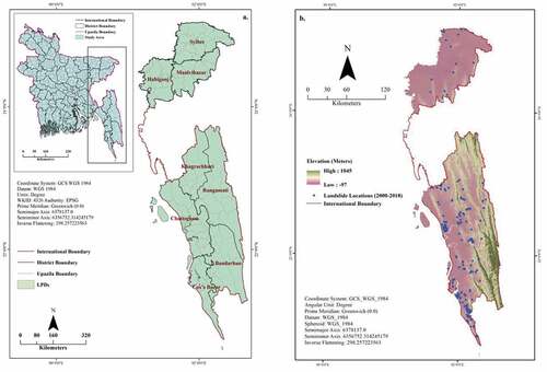
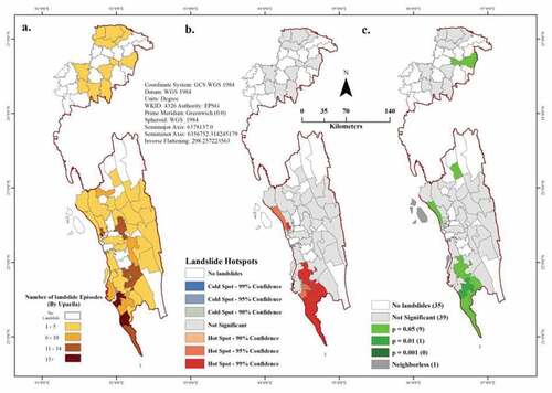
Figure represents the geographical distribution of landslide episodes as well as their hotspots by Upazila. The Upazilas under Eastern Hilly Districts (Chattogram, Cox’s Bazar and hill tract regions- Rangamati, Khagrachari, and Bandarban) have faced more landslide episodes (188, 92%) and suffered more deaths (691, 95%) and injuries (1014, 99.71%) than those the Upazilas under the North East Districts (Sylhet, Moulvibazar, and Habiganj- 16, 8%; 36, 5%; 3, 0.29% respectively). Among these LPDs, Habiganj district faced the lowest quantity of landslide events (2, 1%), while the highest number of landslide episodes occurred in Chattogram (65, 31.90%) followed by Cox’s Bazar (63, 30.90%), Bandarban (31, 15.20%) and Rangamati (17, 8.30%). According to the hotspot analysis, four upazilas (Sitakunda, Bayejid Bostami, Khulsi, and Panchlaish) from Chattogram district, five upazilas (Teknaf, Ukhiya, Chakaria, Ramu, and Cox’s Bazar Sadar) from Cox’s Bazar districts, and Naikhongchhari upazila from Bandarban district have been identified as previous landslide hotspots in the south-eastern region of Bangladesh. There is no hotspot in the north-eastern areas and no cold spot throughout the LPDs (as illustrates in Figure ).
Figure 6. (a) Distribution of landslide episodes (by Upazila); (b) Landslide hotspots analysis using GIS spatial statistic tool (Hotspot analysis: Getis-Ord Gi*); (c) LISA significance map
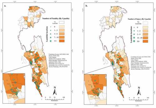
The spatial distribution of landslide-related fatalities and injuries are shown in Figure . According to the database, landslide processes cause the highest number of deaths and injuries in the hilly south-eastern regions. In the hilly north-eastern area, the number of fatalities is comparatively higher than the number of injuries, while both the number of deaths and injuries are much lower than that of south-eastern regions. In terms of fatalities, the highest percentage of people died (279, 38.4%) also in Chattogram due to landslides followed by Cox’s Bazar (179, 24.6%), Rangamati (110, 15.1%) and Bandarban (91, 12.5%). On the other hand, almost 50% of injured people belong to Bandarban district, and more than 40% are originated from Chattogram and Cox’s Bazar. However, the most significant number of landslide events (84, 41.18%) caused 1–2 fatalities, while 77 landslides (37.75%) results in 3–9 deaths. Additionally, the fatal landslides (11, 5.4%) mostly occurred in Chattogram, Rangamati, Bandarban, and Cox’s Bazar, which have more than ten deaths. Additionally, there are some previous landslide episodes with zero fatality as the number is highest in Chattogram (10), followed by Cox’s Bazar (6) and Bandarban (6). On the other hand, in terms of injury, Bandarban (479 injuries, 47%) has the highest number of injuries followed by Chattogram (251, 25%), Cox’s Bazar (192, 19%) and Rangamati (80, 8%). However, most of the fatal landslides, considering injuries, happened in the Chattogram City Corporation, Ukhiya, and Teknaf Upazila, while Moulvibazar and Habiganj district has no injuries recorded in the last 19 years. On the other hand, BDLS-DAT revealed that 61.8% (126) landslide episodes have occurred in the whole study area for 19 years, which have no reported injuries.
Figure 7. Spatial distribution of (a) Reported fatalities and (b) Reported injuries during 2000–2018
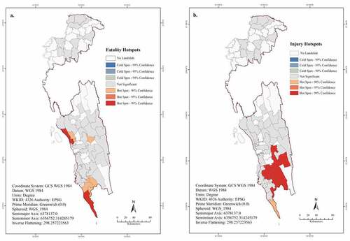
However, there are six upazilas identified as hotspots at a 99 percent confidence level considering landslide-induced fatalities, which also belong to Chattogram (Sitakunda, Bayejid Bostami, Khulsi, and Panchlaish) and Cox’s Bazar district (Ukhiya and Teknaf) as most of the fatal landslides happened in those districts, as shown in Figure ). On the other hand, Hathazari, Kaptai, Ramu, and Naikhongchhari Upazila also recognized as hotspots at a 90 percent confidence level. There is no cold spot for fatality, as well as for injury (as represents in Figure ). The spatial statistical analysis also reflects the hotspots considering the landslide-induced injuries, and most of the upazilas under Bandarban districts are recognized as hotspot with a 99 percent confidence level. However, there is no hotspot for south-eastern regions for both fatality and injury.
Figure 8. Hotspot analysis of landslide-induced fatality and injury; (a) Fatality hotspot and (b) Injury hotspot using GIS spatial statistic tool (Hotspot analysis: Getis-Ord Gi*)
3.3. Spatial variation of triggering factors
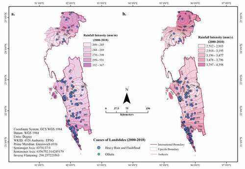
Landslides in Bangladesh are mainly triggered by substantial rainfall, rain, flash flood, hill cutting, mining, or quarry and earthquake, while the triggering factors vary throughout the study areas as well as from season to season. Landslides induced by heavy rainfall are noticeable almost in every LPDs during the study period; however, they mostly happened during monsoon. In LPDs, the average rainfall is 623 millimeters in monsoon, which is more than that of pre-monsoon, post-monsoon, and winter (196, 140 and 10 millimeters correspondingly) (BMD, Citation2019). Figure reflects the monthly and yearly rainfall intensity of 10 stations (Sylhet, Srimangal, Sandwip, Sitakunda, Ambagan, Chattogram, Rangamati, Kudubdia, Cox’s Bazar and Teknaf) along with the reported causes of landslides in LPDs. The figure shows previous landslides are more concentrated near the areas where the rainfall intensity is high and the landslide hotspots are also located in the high rainfall intensity areas (Figure ).
According to BDLS-DAT, 170 landslides (83% of all previous landslides) were induced by heavy rainfall in a short period among 204 during the 19 years. Among those, the highest number of rainfall-induced landslides (164 events, 80.4%) followed by rain and flash flood (10, 5%), hill cutting (5, 2.5%), and earthquake (5, 2.5%) occurred during the heavy showers of the monsoon season. However, only 2% of landslide episodes were triggered by heavy rainfall as same as hill cutting (2%), followed by mining or quarry and earthquake in the pre-monsoon. On the other hand, during post-monsoon, landslides events were mostly triggered by some occasional heavy rainfalls in October, whereas in winter, landslides are highly induced by mining or quarry (4, 2%), after that hill cutting. In terms of fatalities and Injuries, landslides triggered by heavy rainfall caused the highest number of deaths (634, 90%) and injuries (988, 97.15%). Additionally, 30 people died due to rain and flash-flood induced landslides, and 20 injuries happened due to landslides triggered by hill cutting.
Figure 9. (a) Average intensity of monthly rainfall (2000–2018); and (b) Average intensity of annual rainfall (2000–2018)
In Cox’s Bazar district, the highest number of landslide events, fatalities and injuries (58, 175 and 189 respectively) are also induced by heavy rainfall, followed by hill cutting (4 incidences, four deaths, three injuries) and rain along with flash floods (1 event with zero casualties). Chattogram district is the second affected district due to rainfall-induced landslides with 56 incidents, 260 fatalities, and 245 injuries followed by Bandarban (28 events, 85 deaths, and 465 injuries) and Rangamati (14 landslides with 110 deaths and 80 injuries). In Chattogram, hill cutting is the second leading cause of previous landslide events like Bandarban and Sylhet, whereas, in Khagrachari, most of the fatal landslides are mainly induced by rain and flash flood (7 landslides left 24 people died). However, Sylhet district is profoundly affected by mining or quarry induced landslide events (6 landslides with 17 fatalities) in the study period.
3.4. Yearly distribution of landslide-related fatalities and injuries
The inter-annual variations of landslide related fatalities and injuries are revealed in Figure . There is a high level of the inconsistency of landslide occurrences from year to year; however, the trend is upward in the last 19 years (Figure ). It is found that landslide-related causalities were recorded almost every year except in the year 2001, and the annual number of landslides is increasing over the study period, with more events from 2007 to 2018. However, out of 6 landslides, two events were reported (without fatality and injury) in the newspaper during 2001 with damage information. Two minima are present in 2014 and 2016 regarding the number of dead people (1 person in each year); the maximum number of deaths was recorded in 2017 (176) followed by 2007 (127) and 2012 (113). On the other hand, in the last 19 years, the highest number of injuries happened in 2012, 2017, and 2007; the figures were 461, 166 and 125 respectively, while there was no injury recorded in 2001, 2005, 2013 and 2016. In the years of 2002 and 2014, the minimum number of casualties were documented during the 19 years.
Figure 10. Inter-annual variations of landslide related fatalities and injuries, 2000–2018
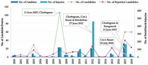
Although landslide is an annual hazard in Bangladesh, there was a gap of one or two years between two or more the fatal landslide with the inclusion of new exposed places; for example, the landslide related fatalities and injuries was higher in 2007, 2012, 2015, 2017 and 2018 than those of the remaining years; and had unusually continuous heavy rainfall. However, Bangladesh faced 11 landside episodes yearly that caused 38 deaths and 54 injuries on an average. The highest number of landslide events (only 17 was reported in newspapers out of 106 incidents) occurred in 2007, with 127 deaths and 125 injuries.
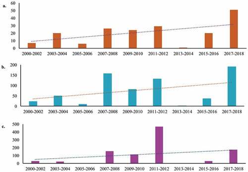
Figure 11. Trends of landslide events during monsoon (June-September) in Bangladesh; (a) Landslide events; (b) Number of fatalities; (c) Number of injuries; 2000–2018
3.5. Seasonal and monthly variations of landslide fatalities and injuries
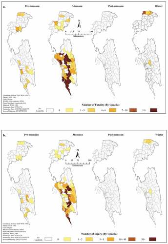
The seasonal variation of landslide related casualties (fatality and injury) from 2000 to 2018, are shown in Figure that indicates the monsoon season to have more deaths than that of other seasons. Therefore, in Bangladesh, monsoon (184 events, 682 deaths with 1003 injuries) is the most destructive season for landslides, followed by pre-monsoon (considering 11 landslide incidents and 10 Injuries), winter (7 episodes with two wounds) and post-monsoon (2 events and two injuries). However, the second-highest deaths (21 deaths) happened in pre-monsoon, followed by winter (20 deaths) and post-monsoon season (4 fatalities).
Figure 12. Spatial distribution of landslide related fatalities and injuries in different seasons, 2000–2018; (a) Seasonal variation of Upazila-wise fatality; (b) Seasonal variation of Upazila-wise injury
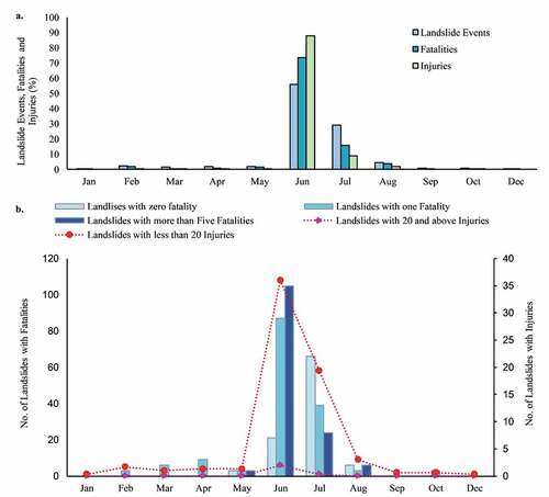
According to BDLS-DAT, there are 204 landslide episodes with deaths and injured people for which the month of the incidence is identified in Figure (a). The highest number of landslide events (114, 56%) including deaths (535, 74%) and injuries (892, 88%) were reported in June, whereas in July, 116 people deceased and 91 injured due to 59 landslide incidence (29%) which is the second largest. The lowest number of landslide events were recorded in December (1) and January (1) with the lowermost fatalities (3 and 2 correspondingly), while no one is injured during these months. On the other hand, in November, there is no landslide event reported in the last 19 years. The study also revealed that out of 114, only seven landslide events were recorded with zero fatality, while 29 documented with one death and 35 landslides have more than five deaths during June in the last 19 years, as illustrated in Figure (b).
Figure 13. Monthly distribution of landslide-related fatalities and injuries (a) Percentage of landslide events, fatalities and injuries by months; and (b) Landslide events with fatality with zero, one and more than five by month; and injuries with less than 20 and at least 20 injuries
4. Discussion
Previous studies that have studied the landslide fatalities and injuries on a global scale, were mostly based on online news articles with reasonable estimations about landslide fatalities (Froude & Petley, Citation2018; D. Petley, Citation2012; D. N. Petley, Citation2005) and recently Haque et al. (Citation2019) have studied the global fatal landslides for 1995–2014. However, still, there is a lack of national database, which is exceedingly indispensable to understand the country-specific pattern of landslide incidence for taking essential measures regarding the risk and vulnerability reduction. Additionally, this research enables to assess all the previous reported landslide related fatalities and for a more extended period, which is not detected by earlier studies.
The study identifies 204 landslide events reported with consequences that result in 727 deaths and 1017 injuries for the period between 2000 and 2018 in Bangladesh. According to the BDLS-DAT, the average number of annual landslides is 19 and the annual growth rate is 4% during the study period that causes 38 fatalities and 54 injuries yearly on an average. The result of the study, consistent with formerly published works (Froude & Petley, Citation2018; Haque et al., Citation2019; D. Petley, Citation2012), indicates that the annual number of fatal landslides is increasing unpredictably as new places are exposing every year with more landslides between 2007 and 2018 (Figure ); the similar trends in Nepal and some newly emerging industrialized countries like India, China, Malaysia, etc.
Accordingly, 83% of previous landslides are primarily induced by heavy rainfall, and hence monsoon summer is the most damaging season as it has more fatal landslide episodes than that of other seasons (Figure ), the trend is also similar with prior studies (Haque et al., Citation2019; D. Petley, Citation2012). Furthermore, the frequency of landslide events has increased in Nepal, Bhutan and Northern Pakistan during the monsoon season (Froude & Petley, Citation2018). This study also finds upward trends of reported landslide events in Bangladesh (Figure ) as landslides are increasing or landslide events are reported more than before due to the recent improvement of communication systems. The result also reveals that landslide hotspots are located near the high rainfall intensity areas during the study period, and most of the fatal landslides are primarily triggered by the heavy rainfall as reported in the news reports, for example, 2007, 2012, 2015, 2017 and 2018 landslide events. Additionally, due to climate change, the southeastern part of Bangladesh is experiencing a higher concentration of monsoon rain recently, which is making the landslide events more frequent and fatal than before (Ahmed, Citation2014; Mutizwa-Mangiza et al., Citation2011).
In terms of spatial distribution, Chattogram has already been recognized as one of the most vulnerable cities due to multiple landslide events (Mahmood & Khan, Citation2010; Mia et al., Citation2016; Sultana, Citation2013) which is also recognized by this study. In Chattogram, every year, with the exclusion of 2001, 2002, 2010, and 2016, landslides resulting in severe casualties, property damage, and economic loss. For instance, on 11 June 2007, due to a landslide event, 127 people died, over 100 were injured, 22 families were directly affected, 72 families were displaced from their houses who were bound to take shelter in another safe location and about 200 families were permanently displaced (Chisty, Citation2014; Mia et al., Citation2016). After that, on 27 June 2012, another landslide and mudflow induced by torrential rainfall happened in Chattogram city, which causes 26 fatalities, and most of them are from Khulsi Thana. The spatial statistical analysis also revealed that Chattogram city is the hotspot in terms of landslide incidence as well as the landslide-induced fatalities. In terms of landslide intensity, Cox’s Bazar is the second affected district where Cox’s Bazar Sadar, Ukhiya and Teknaf Upazila are highly exposed due to landslide incidence triggered by heavy rainfall which is also supported by the hotspot analysis.
However, landslide phenomena are consistently aggravating near the urban area mostly due to the rapid expansion of the built-up area, high population density, inappropriate land use, rampant hill cutting along with massive deforestation (Ahmed, Citation2015; Ahmed & Rubel, Citation2013; Khan et al., Citation2012) and those causes are also valid for Pakistan and India (Atta Ur et al., Citation2010). Although the hilly north-eastern part is less affected by landslides and around 5-12% of the total hills, including tillas, are cut or demolished annually in different forms at different parts of that region which can increase the landslide vulnerability (Islam et al., Citation2006). Additionally, the concentration of illegal informal settlements is very high in risky hill slopes or hilltops, especially near the urban centers. Literature shows that more than 500,000 impoverished people are living in informal settlements on the risky foothills of Chattogram city (Islam, Citation2008; I. Khan, Citation2008) by cutting hills that is also an increasing problem in India and Nepal (Froude & Petley, Citation2018). On the other hand, around 2.3 million people are directly facing landslide risks in Cox’s Bazar, of whom 3 lacs live in the risky 9657 hectares of areas which are used to make illegal accommodations for 13,826 informal settlers (Aziz, Citation2017). In Ukhiya and Teknaf Upazila, the highest number of people were injured due to landslides as most of the Rohingyas are living in the hilly areas. According to the recent statistics, in Ukhiya, around 2 lakh Rohingyas are residing at their makeshift camps with a severe risk of landslide vulnerability (Shuvo, Citation2018). Apart from this, the Chattogram Hill Tracts area is a place of 11 tribes that are utterly dependent on the hilly environments for their livelihoods. Traditional shifting cultivation (locally known as Jhum), conducted by the tribal communities, is also another leading cause for landslides as it declines the forest cover and enhances inappropriate land use that leads to severe soil erosion (Rasul et al., Citation2004).
Hence the physical, social, political, and environmental settings of this area are diverse. People are living on the hillslopes and hilltops illegally by overlooking the landslide risks as most of them are landless and poor. According to the news reports, in Cox’s Bazar, more than 30% of the total hill and forest land (89,162 hectares) has already been grabbed by the local influential who make the houses illegally and poor people live there as a renter. Most of them are reluctant to move from their home to the shelter to the fear of thefts during the disaster, while the district administration is very active in evacuating the inhabitants safely during every monsoon. Additionally, the rising housing demand for continually increasing population, environmental refugees from coastal regions as well as Rohingyas from Myanmar, is also the rational reasons behind the increasing informal settlements on risky foothills that are the key contributing factor driving the high causality rate in Bangladesh. Though a resettlement policy has already been developed and two sites are primarily identified for relocating 2,00,000 immensely vulnerable people living along the hill slopes in Chattogram City (Sarker & Rashid, Citation2013), such initiatives are not applicable in the Chattogram Hill Tracts due to the Chattogram Hill Tracts Peace Accord-1997.
Additionally, there is a lack of strict hill management policy (national hill management policy preparation is in the process) (Sarker & Rashid, Citation2013) regarding forest cleaning, tree plantation and implementation of engineering measures to protect demolished hills, regulating the growth of residential areas including other construction activities (Chisty, Citation2014). This situation encouraged local people to build illegal informal settlements on foothills or hilltops (Ahmed, Citation2014) that increased the landslide related causalities. Though the Building Construction Rules by Chattogram Development Authority (CDA) also emphasized the hill cutting issues which entails more revelation and proper implementation.
Although Bangladesh has various Hazard Specific Disaster Management Plan (Earthquake Management Plan, Cyclone Shelter Plan, Disaster Resilient Cluster Housing, Tsunami Response, etc.) at different administrative strata under the Disaster Management Regulatory Framework, there is a lack of landslide specific plans. Hence, there is a paucity of comprehensive, well-integrated response by the Government that required a sustainable landslide hazard management. Existing government policies are mostly oriented to emergency response (such as eviction, evacuation, temporary relocation, rescue, and relief) that can reduce the direct loss of landslides in terms of fatality and injury that are already verified in the 2018 landslide events. In recent years, most importantly, the number of fatal and injured people was lower than that of previous years due to the high emergency response, though the number of landslide events was much higher compared to the preceding years. For example, the higher number of landslides occurred during 2018; the number of fatalities and injuries is not as much as higher compared to prior years, probably due to the high emergency response (mostly temporary relocation, evacuation, rescue and relief). At the same time, a committee was established to enhance cost-effected engineering measuring like reinforcement walls, proper drainage, and soil conservation. However, sustainable landslide management policy should emphasize on the social settings of landslide-prone areas, the socio-economic vulnerability as well as the availability of resources and capacity.
Finally, the study recognized the underestimation of the total consequences of landslide events as the study only considers the fatalities and injuries. The landslide damaged was omitted from the database due to data unavailability. In terms of death and injury, the demographic profile (gender and age) of the victims was not anticipated in the database as the information is mostly inconsistent and unavailable especially for the multiple and fatal events. Furthermore, the exact figure of fatalities may be meagerly miscalculated, because the database is unable to estimate the injured people as a died who left after a week to months of that particular landslide events. Additionally, the missing people were considered as killed in the database. Additionally, the geological causes of landslides (soil structure, slope stability, relief, land use, and land cover etc.) were not considered in this study. However, the study will be beneficial for increasing the consciousness of the societies in understanding the geographical pattern of landslide incidence along with their casualties, and supportive for the policymakers in developing sustainable risk reduction strategies as it is the first attempt to prepare a landslide database in Bangladesh based on landslide-induced losses.
5. Conclusions
The study prepared a database on 204 reported landslides incidence in Bangladesh for the 19 years from 2000 to 2018, that have caused 727 fatalities and 1017 injuries. During the study period, a total of eight and five districts identified as LPDs and most affected districts (south-eastern region), respectively. In Bangladesh, according to the study, the average number of annual landslides is 19, with a 4% yearly growth rate. The study also identifies that 38 people were deceased and 54 people were injured yearly on average due to landslides during the study period. Chattogram and Cox’s Bazar districts are recognized as hotspots statistically, considering the previous landslide episodes and related fatalities.
Remarkably the study finds that landslide event has mostly happened during monsoon throughout the LPDs. The highest number of landslide related fatalities and injuries were reported in June, followed by July, which was mainly triggered by heavy rainfall. Additionally, the trends of the occurrence of landslides are upwards, while the fatalities and injuries vary year to year. Nevertheless, a landslide cannot be averted like another natural disaster, but their consequences can be reduced through investigating and further developing both structural and organizational (alarm system, emergency planning, and awareness creation) safety strategies. Therefore, the results of the study can be used by the researchers, decision-makers, and stakeholders for planning and implementing such policies.
However, more historical research is required for improving this catalog as well as for understanding the intensity and magnitude of landslide incidence in Bangladesh as well as in South Asia. The list includes the landslide events only with the primary causative factors; however, landslide hazards are multifactorial. Additional prime investigations are significant to emphasize on the causes and extent of human and environmental impacts on the landslide hazards in the light of climate change. Additionally, the study limits its scope on the landslide-related damage analysis as the data were mostly unavailable, inconsistent, and underreported in the news reports. Further research essential for damage analysis and the potential source to investigate include: a) disaster-related reports from the local administrative office, b) road and rail maintenance records from appropriate government departments and district administrative office, c) insurance company claims, and d) interviews with parties who have been affected by landslides. Apart from these, the south-eastern part of Bangladesh is ecologically, environmentally and socioeconomically sensitive as well as diversified areas which require special attention at the planning stage of development. Therefore, it is essential to assess the social vulnerability to landslide as well as its coping strategies in Bangladesh.
Cover Image
Source: Author
Acknowledgements
The manuscript is highly benefitted from the constructive suggestions of Professor Shukui Tan, College of Public Administration, Huazhong University of Science and Technology. The author would like to concede the effort of Rahul Saha, Department of Geography and Environment, Jagannath University, for his assistance in preparing some figures. The author is profoundly thankful to Humayra Jannat Limu, Umma Rumman and Sangeeta Biswas, Department of Geography and Environment, Jagannath University, who helped to screen the newspaper articles to generate this database. The paper has also been benefited by valuable inputs from Enayet Hossain, Doctoral student of Economics at Texas Tech University. Furthermore, the author also grateful to the staff of the Central Library (Newspaper Section) at the University of Dhaka for their considerable support throughout the newspaper search. The author also thanks the Department of Disaster Management, District Administrations, Bangladesh Meteorological Department, Police Departments, Fire Service, and Civil Defense for their contribution to data preparation.
Additional information
Funding
Notes on contributors

Neegar Sultana
Neegar Sultana, a PhD researcher in Land Resource Management under the College of Public Administration at Huazhong University of Science and Technology, China, has been teaching in the Department of Geography and Environment at Jagannath University, Dhaka since 2013. The author studied geography and environment at the University of Dhaka, Bangladesh, and during five years of her working time contributes seven articles in national and international journals with one conference proceedings about disaster management, environmental pollution, causal effects on early marriage, regional disparity, rural development, and transport disadvantages. Previous research work reflects the author’s interest in dealing with environmental issues along with social and regional aspects of a different disadvantaged group in different geographical perspectives. Apart from this, Mrs. Sultana also fascinated to work on the emerging issues in the context of regional cooperation and integration among Asian countries.
References
- Abella, E. C., & Van Westen, C. (2007). Generation of a landslide risk index map for Cuba using spatial multi-criteria evaluation. Landslides, 4(4), 311–26. https://doi.org/10.1007/s10346-007-0087-y
- Ahmed, B. (2014). Landslide susceptibility mapping using multi-criteria evaluation techniques in Chittagong Metropolitan Area, Bangladesh. Landslides, 12(6), 1077–1095. https://doi.org/10.1007/s10346-014-0521-x
- Ahmed, B. (2015). Landslide susceptibility modelling applying user-defined weighting and data-driven statistical techniques in Cox’s Bazar Municipality, Bangladesh. Natural Hazards, 79(3), 1707–1737. https://doi.org/10.1007/s11069-015-1922-4
- Ahmed, B., & Dewan, A. (2017). Application of bivariate and multivariate statistical techniques in landslide susceptibility modeling in Chittagong city corporation, Bangladesh. Remote Sensing, 9(4), 304. https://doi.org/10.3390/rs9040304
- Ahmed, B., & Rubel, Y. (2013). Understanding the issues involved in urban landslide vulnerability in Chittagong metropolitan area, Bangladesh. Association of American Geographers (AAG). https://discovery.ucl.ac.uk/id/eprint/1418959
- Alam, E., Chowdhury, M., & Akbar, M. (2005). Aspects of socio-environmental problems resulting from hill cutting in Chittagong city of Bangladesh: Local people’s perspectives. Pakistan Journal of Life and Social Sciences, 3(8), 1048–1052.
- Alexander, D. (2005). Vulnerability to landslides. In Landslide hazard and risk (pp. 175–198). Wiley.
- Anderson, M. G., Holcombe, E., Blake, J. R., Ghesquire, F., Holm-Nielsen, N., & Fisseha, T. (2011). Reducing landslide risk in communities: Evidence from the Eastern Caribbean. Applied Geography, 31(2), 590–599. https://doi.org/10.1016/j.apgeog.2010.11.001
- Atta Ur, R., Khan, A. N., Collins, A. E., & Qazi, F. (2010). Causes and extent of environmental impacts of landslide hazard in the Himalayan region: A case study of Murree, Pakistan. Natural Hazards, 57(2), 413–434. https://doi.org/10.1007/s11069-010-9621-7
- Aziz, A. (2017, June 15). 300,000 people facing risk from landslides in Cox’s Bazar. Dhaka Tribune. https://www.dhakatribune.com/bangladesh/nation/2017/06/15/300000-people-facing-risk-landslides-coxs-bazar/
- Badoux, A., Andres, N., Techel, F., & Hegg, C. (2016). Natural hazard fatalities in Switzerland from 1946 to 2015. Natural Hazards and Earth System Sciences, 16(12), 2747–2768. https://doi.org/10.5194/nhess-16-2747-2016
- Benn, J. (2005). Landslide events on the west coast, South Island, 1867–2002. New Zealand Geographer, 61(1), 3–13. https://doi.org/10.1111/j.1745-7939.2005.00001.x
- Bera, S., Guru, B., & Ramesh, V. (2019). Evaluation of landslide susceptibility models: A comparative study on the part of Western Ghat Region, India. Remote Sensing Applications: Society and Environment, 13, 39–52. https://doi.org/10.1016/j.rsase.2018.10.010
- BMD. (2019). Bangladesh mateorological department. In 2000-2018. Agargoan.
- Brammer, H. (1996). The geography of the soils of Bangladesh. University Press.
- CDMP-II. (2012). Landslide inventory and landuse mapping (DEM Preparation, Precipitation Threshold Value and Establishment of Early Warning Device). Dhaka, Bangaldesh: Ministry of Food and Disaster Management (MoFDM), Disaster Management and Relief Division (DMRD), Government of People's Republic of Bangladesh. /PDIS-11-11-0999-PDN
- Chakma, A., & Barua, S. K. (2017, June 19). Horror strikes hills. The Daily Star. https://www.thedailystar.net/frontpage/landslides-kill-130-1419796
- Chau, K., Sze, Y., Fung, M., Wong, W., Fong, E., & Chan, L. (2004). Landslide hazard analysis for Hong Kong using landslide inventory and GIS. Computers & Geosciences, 30(4), 429–443. https://doi.org/10.1016/j.cageo.2003.08.013
- Chen, C.-W., Oguchi, T., Hayakawa, Y. S., Saito, H., & Chen, H. (2017). Relationship between landslide size and rainfall conditions in Taiwan. Landslides, 14(3), 1235–1240. https://doi.org/10.1007/s10346-016-0790-7
- Chisty, K. U. (2014). Landslide in Chittagong city: A perspective on hill cutting. Journal of Bangladesh Institute of Planners, 7, 1–17. Retrieved from http://bip.org.bd/SharingFiles/journal_book/20150509125147
- Chowdhury, M. (2017). Rangamati landslides batter 1,700 families. https://bdnews24.com/bangladesh/2017/06/19/rangamati-landslides-batter-1700-families
- Corominas, J., van Westen, C., Frattini, P., Cascini, L., Malet, J. P., Fotopoulou, S., Catani, F., Van Den Eeckhaut, M., Mavrouli, O., Agliardi, F., Pitilakis, K., Winter, M. G., Pastor, M., Ferlisi, S., Tofani, V., Hervás, J., & Smith, J. T. (2013). Recommendations for the quantitative analysis of landslide risk. Bulletin of Engineering Geology and the Environment, 73, 209–263. https://doi.org/10.1007/s10064-013-0538-8
- Dai, F. C., & Lee, C. (2001). Frequency–volume relation and prediction of rainfall-induced landslides. Engineering Geology, 59(3–4), 253–266. https://doi.org/10.1016/S0013-7952(00)00077-6
- Dai, F. C., Lee, C.-F., & Ngai, Y. Y. (2002). Landslide risk assessment and management: An overview (Vol. 64). Elsevier.
- Dowling, C. A., & Santi, P. M. (2014). Debris flows and their toll on human life: A global analysis of debris-flow fatalities from 1950 to 2011. Natural Hazards, 71(1), 203–227. https://doi.org/10.1007/s11069-013-0907-4
- Evans, S. G. (2018). Fatal landslides and landslide risk in Canada 1. In D. Cruden (Ed.), Landslide risk assessment (1st ed., pp. 185–196). Routledge.
- Franks, C. (1999). Characteristics of some rainfall-induced landslides on natural slopes, Lantau Island, Hong Kong. Quarterly Journal of Engineering Geology and Hydrogeology, 32(3), 247–259. https://doi.org/10.1144/GSL.QJEG.1999.032.P3.04
- Froude, M. J., & Petley, D. N. (2018). Global fatal landslide occurrence from 2004 to 2016. Natural Hazards and Earth System Sciences, 18(8), 2161–2181. https://doi.org/10.5194/nhess-18-2161-2018
- Gao, L., Zhang, L., & Cheung, R. (2018). Relationships between natural terrain landslide magnitudes and triggering rainfall based on a large landslide inventory in Hong Kong. Landslides, 15(4), 727–740. https://doi.org/10.1007/s10346-017-0904-x
- Gariano, S. L., & Guzzetti, F. (2016). Landslides in a changing climate. Earth-Science Reviews, 162, 227–252. https://doi.org/10.1016/j.earscirev.2016.08.011
- GLIDE. (2019, December). On-line global disaster identifier (GLIDE) database. http://www.glidenumber.net/glide/public/search/search.jsp
- Guzzetti, F. (2000). Landslide fatalities and the evaluation of landslide risk in Italy. Engineering Geology, 58(2), 89–107. https://doi.org/10.1016/S0013-7952(00)00047-8
- Guzzetti, F., Cardinali, M., & Reichenbach, P. (1994). The AVI Project: A bibliographical and archive inventory of landslides and floods in Italy. Environmental Management, 18(4), 623–633. https://doi.org/10.1007/BF02400865
- Guzzetti, F., Carrara, A., Cardinali, M., & Paola, R. (1999). Landslide hazard evaluation: A review of current techniques and their application in a multi-scale study, Central Italy (Vol. 31). Elsevier.
- Haque, U., Blum, P., da Silva, P. F., Andersen, P., Pilz, J., Chalov, S. R., Malet, J.-P., Auflič, M. J., Andres, N., Poyiadji, E., Lamas, P. C., Zhang, W., Peshevski, I., Pétursson, H. G., Kurt, T., Dobrev, N., García-Davalillo, J. C., Halkia, M., Ferri, S., Engström, J., & Keellings, D. (2016). Fatal landslides in Europe. Landslides, 13(6), 1545–1554. https://doi.org/10.1007/s10346-016-0689-3
- Haque, U., da Silva, P. F., Devoli, G., Pilz, J., Zhao, B., Khaloua, A., Wilopo, W., Andersen, P., Lu, P., Lee, J., Yamamoto, T., Keellings, D., Wu, J.-H., & Glass, G. E. (2019). The human cost of global warming: Deadly landslides and their triggers (1995-2014). The Science of the Total Environment, 682, 673–684. https://doi.org/10.1016/j.scitotenv.2019.03.415
- Hilker, N., Badoux, A., & Hegg, C. (2009). The Swiss flood and landslide damage database 1972–2007. Natural Hazards and Earth System Sciences, 9(3), 913–925. https://doi.org/10.5194/nhess-9-913-2009
- Holcombe, E., & Anderson, M. (2010). Tackling landslide risk: Helping land use policy to reflect unplanned housing realities in the Eastern Caribbean. Land Use Policy, 27(3), 798–800. https://doi.org/10.1016/j.landusepol.2009.10.013
- Islam, M. S. (2008). Hill cutting in Chittagong and environmental degradation [Paper presentation]. Proceedings of the special conference on Hill Cutting, Forum for Planned Chittagong. Chittagong.
- Islam, M. S., Hasan, G. J., & Chowdhury, M. A. I. (2006). Destroying hills in the northeastern part of Bangladesh: A qualitative assessment of extent of the problem and its probable impact. International Journal of Environmental Science & Technology, 2(4), 301–308. https://doi.org/10.1007/BF03325890
- Keefer, D. K., & Larsen, M. C. (2007). Assessing landslide hazards. Science, 316(5828), 1136–1138. https://doi.org/10.1126/science.1143308
- Khan, I. (2008). Hill cutting in Chittagong city corporation area: Its causes and the consequences [PhD Dissertation]. Khulna University,
- Khan, Y. A., Lateh, H., Baten, M. A., & Kamil, A. A. (2012). Critical antecedent rainfall conditions for shallow landslides in Chittagong city of Bangladesh. Environmental Earth Sciences, 67(1), 97–106. https://doi.org/10.1007/s12665-011-1483-0
- Kirschbaum, D., Stanley, T., & Zhou, Y. (2015). Spatial and temporal analysis of a global landslide catalog. Geomorphology, 249, 4–15. https://doi.org/10.1016/j.geomorph.2015.03.016
- Kirschbaum, D. B., Adler, R., Hong, Y., Hill, S., & Lerner-Lam, A. (2010). A global landslide catalog for hazard applications: Method, results, and limitations. Natural Hazards, 52(3), 561–575. https://doi.org/10.1007/s11069-009-9401-4
- Kjekstad, O., & Highland, L. (2009). Economic and social impacts of landslides. In Landslides–disaster risk reduction (pp. 573–587). Kyoji Sassa, Paolo Canuti: Springer.
- Lacasse, S., Nadim, F., & Kalsnes, B. (2010). Living with landslide risk. Geotechnical Engineering Journal of the SEAGS & AGSSEA, 41(4).
- Li, Z., Nadim, F., Huang, H., Uzielli, M., & Lacasse, S. (2010). Quantitative vulnerability estimation for scenario-based landslide hazards. Landslides, 7(2), 125–134. https://doi.org/10.1007/s10346-009-0190-3
- Mahmood, A. B., & Khan, M. H. (2010). Landslide vulnerability of Bangladesh hills and sustainable management options: A case study of 2007 landslide in Chittagong city [Paper presented]. SAARC Workshop on Landslide Risk Management in South Asia, Thimpu, Bhutan.
- Mia, M., Sultana, N., & Paul, A. (2016). Studies on the causes, impacts and mitigation strategies of landslide in Chittagong city, Bangladesh. Journal of Environmental Science and Natural Resources, 8(2), 1–5. https://doi.org/10.3329/jesnr.v8i2.26854
- Mutizwa-Mangiza, N., Arimah, B., Jensen, I., Yemeru, E., & Kinyanjui, M. (2011). Cities and climate change: Global report on human settlements (Global Report on Human Settlements), 250. UN-HABITAT.
- Nadim, F., Kalsnes, B., & Solheim, A. (2014). Plenary: Progress of living with landslide risk in Europe. In Landslide science for a safer geoenvironment (pp. 3–20). Kyoji Sassa, Paolo Canuti, Yueping Yin.
- Parker, R. N., Densmore, A. L., Rosser, N. J., De Michele, M., Li, Y., Huang, R., Whadcoat, S., & Petley, D. N. (2011). Mass wasting triggered by the 2008 Wenchuan earthquake is greater than orogenic growth. Nature Geoscience, 4(7), 449. https://doi.org/10.1038/ngeo1154
- Pennington, C., Freeborough, K., Dashwood, C., Dijkstra, T., & Lawrie, K. (2015). The national landslide database of great Britain: Acquisition, communication and the role of social media. Geomorphology, 249, 44–51. https://doi.org/10.1016/j.geomorph.2015.03.013
- Pereira, S., Zêzere, J. L., Quaresma, I. D., & Bateira, C. (2014). Landslide incidence in the North of Portugal: Analysis of a historical landslide database based on press releases and technical reports. Geomorphology, 214, 514–525. https://doi.org/10.1016/j.geomorph.2014.02.032
- Petley, D. N. (2010). On the impact of climate change and population growth on the occurrence of fatal landslides in South, East and SE Asia. Quarterly Journal of Engineering Geology and Hydrogeology, 43(4), 487–496. https://doi.org/10.1144/1470-9236/09-001
- Petley, D. (2012). Global patterns of loss of life from landslides. Geology, 40(10), 927–930. https://doi.org/10.1130/g33217.1
- Petley, D. N., Dunning, S., Rosser, N., & Hungr, O. (2005). The analysis of global landslide risk through the creation of a database of worldwide landslide fatalities. In O. Hungr, R. Fell, R. Couture, E. Eberhardt (Eds.), Landslide risk management (pp. 367–374).
- Petley, D. N., Hearn, G. J., Hart, A., Rosser, N. J., Dunning, S. A., Oven, K., & Mitchell, W. A. (2007). Trends in landslide occurrence in Nepal. Natural Hazards, 43(1), 23–44. https://doi.org/10.1007/s11069-006-9100-3
- Rabby, Y. W., & Li, Y. (2018). An integrated approach to map landslides in Chittagong Hilly Areas, Bangladesh, using Google Earth and field mapping. Landslides, 16(3), 633–645. https://doi.org/10.1007/s10346-018-1107-9
- Rahman, M., Ahmed, B., Huq, F., Rahman, S., & Al-Hussaini, T. (2016). Landslide inventory in an urban setting in the context of Chittagong Metropolitan Area, Bangladesh [Paper presentation]. 3rd International Conference on Advances in Civil Engineering (ICACE), Chittagong, Bangladesh.
- Rashid, H. (1991). Geography of Bangladesh. University Press Ltd.
- Rasul, G., Thapa, G. B., & Zoebisch, M. A. (2004). Determinants of land-use changes in the Chittagong hill tracts of Bangladesh. Applied Geography, 24(3), 217–240. https://doi.org/10.1016/j.apgeog.2004.03.004
- Salvati, P., Petrucci, O., Rossi, M., Bianchi, C., Pasqua, A. A., & Guzzetti, F. (2018). Gender, age and circumstances analysis of flood and landslide fatalities in Italy. Science of the Total Environment, 610–611, 867–879. https://doi.org/10.1016/j.scitotenv.2017.08.064
- Sarker, A. A., & Rashid, A. K. M. M. (2013). Landslide and flashflood in Bangladesh. In R. Shaw, F. Mallick, & A. Islam (Eds.), Disaster risk reduction approaches in Bangladesh. disaster risk reduction (Methods, approaches and practices) (pp. 165–189). Springer.
- Schuster, R. L. (1996). Socioeconomic significance of landslides. In Turner, A. K and Schuster, R.L (Eds.), Landslides: Investigation and mitigation (Vol. 247, pp. 12–35). National Academy Press. Transportation Research Board Special Report.
- Schuster, R. L., & Highland, L. (2001). Socioeconomic and environmental impacts of landslides in the western hemisphere. Citeseer.
- Sen Roy, S., & Balling, R. C., Jr. (2004). Trends in extreme daily precipitation indices in India. International Journal of Climatology: A Journal of the Royal Meteorological Society, 24(4), 457–466. https://doi.org/10.1002/joc.995
- Sepúlveda, S. A., & Petley, D. N. (2015). Regional trends and controlling factors of fatal landslides in Latin America and the Caribbean. Natural Hazards and Earth System Sciences, 15(8), 1821–1833. https://doi.org/10.5194/nhess-15-1821-2015
- Shuvo, M. (2018, April 1). The risky refuge. The Daily Star. https://www.thedailystar.net/frontpage/ukhia-bursting-the-seams-1556272
- Sidle, R. C., & Ochiai, H. (2006). Landslides: Processes, prediction, and land use. In Water resources monograph- 18, 322–326. American Geophysical Union.
- Sultana, T. (2013). Landslide disaster in Bangladesh a case study of Chittagong University Campus. International Journal of Research in Applied, Natural and Social Sciences (IMPACT: IJRANSS), 1(6), 35–42.
- Towashiraporn, P., & Arambepola, N. M. S. I. (2017). Interventions for promoting knowledge, innovations and landslide risk management practices within South and Southeast Asia (WCoE 2014–2017). In K. Sassa, M. Mikos, Y. Yin (Eds.), Advancing culture of living with landslides: WLF 2017 (pp. 347–354). Springer International Publishing.
- UNDP. (2004). Reducing disaster risk: A challenge for development-a global report (United Nations). United Nations.
- UNISDR, U. (2015). Sendai framework for disaster risk reduction 2015–2030 [Paper presentation]. Proceedings of the 3rd United Nations World Conference on DRR, Sendai, Japan.
- Wen, B., Han, Z., Wang, A., Wang, E., & Zhang, J. (2005). Recent landslide disasters in China and lessons learned for landslide risk management. In O. Hungr, R. Fell, R. Couture & E. Eberhardt (Eds.), Landslide risk management (pp. 427–434). AA Balkema Publisher.
- Zhou, C., Lee, C., Li, J., & Xu, Z. (2002). On the spatial relationship between landslides and causative factors on Lantau Island, Hong Kong. Geomorphology, 43(3–4), 197–207. https://doi.org/10.1016/S0169-555X(01)00130-1