
 ?Mathematical formulae have been encoded as MathML and are displayed in this HTML version using MathJax in order to improve their display. Uncheck the box to turn MathJax off. This feature requires Javascript. Click on a formula to zoom.
Abstract
The increase in open dumping and burning of solid waste in Tercha town, Southwest Ethiopia, has become a major environmental and public health concern. This research aims to identify suitable landfill sites for accommodating the increasing amount of solid waste generated as a result of urban expansion in the area. Various criteria such as slope, land use, soil type, distance from settlement, drainage, road, borehole, lithology, and fault were considered to generate a suitability map using the Analytic Hierarchy Process (AHP) procedures. The multi-criteria evaluation methodology was applied to identify suitable sites according to the specified decision rules. The results showed that only 1.9% of the study area was highly suitable for a landfill, while 3% was unsuitable, and 34.91% and 60.1% were moderately and less suitable, respectively. From the highly suitable areas, criteria such as distance from the city center, settlement, and size of the landfill were considered, and Landfill site 4 was identified as the most suitable option. The other candidate sites were ranked lower according to the AHPs. Finally, by considering complex physical and socioeconomic factors, a suitable landfill site has been selected. This research provides valuable guidance to local government officials in establishing proper waste disposal regulations and practices.
1. Backgrounds
Municipal Solid Waste is waste generated by households, and waste of a similar nature generated by commercial and business establishments, industrial and agricultural premises, institutions such as schools and hospitals, public spaces such as parks and streets and construction sites (UN-Habitat, Citation2018). Solid-waste management, collection, treatment, and disposal of solid material that is discarded because it has served its purpose or is no longer useful (Nathanson, Citation2023). Waste management systems require significant attention to solid waste disposal to avoid environmental pollution and health problems (Ambaneh, Citation2016; Ram et al., Citation2021). However, most solid waste disposal sites are located on the outskirts of urban areas, where there are water bodies, crop fields, settlements, and roads (Ebistu & Minale, Citation2013b; Naibbi & Umar, Citation2017; UN-Habitat, Citation2018). Locating proper sites for solid waste disposal and selecting appropriate landfill sites far from residential areas, environmental resource settlement, and water are the main issues for the management of solid waste (Ebistu & Minale, Citation2013a).
The process of waste management consists of collection, transport, processing, recycling, disposal of waste, and monitoring of waste material (Fatimah et al., Citation2020; Zorica et al., Citation2010). One of the most delicate steps in waste management is the selection of the most suitable landfill site, as multiple factors must be considered and there is no universal formula (Nathanson, Citation2023). The major problem is that in addition to natural, environmental and economic factors, complex political and social issues often influence the selection process (Zhou et al., Citation2022). In Africa, rapid urban growth since the 1960s has put pressure on land resources within the areas surrounding cities, and has led to increased generation of waste (Abdel-Shafy & Mansour, Citation2018; Hammer, Citation2003; Linda et al., Citation2020). This problem is aggravated by the open dump nature of waste disposal, especially in the slum areas of most African cities (Haywood et al., Citation2021). Moreover, its effects are also reflected in reduced productivity, low income, poor quality of life, and a deteriorated environment (Khatri & Tyagi, Citation2014).
Several studies indicate that rapid urbanization and population growth in developing countries lead to increased household solid waste generation. A study by Mulugetta et al. (Citation2014) found that urban areas in Ethiopia experienced a surge in solid waste production due to urban expansion. Similarly, Lohri et al. (Citation2018) conducted a comparative analysis in Southeast Asian cities and discovered a positive correlation between urban expansion and household waste generation. Conversely, some studies suggest that urban expansion alone may not be the sole determinant of waste generation, as waste management infrastructure and socioeconomic factors play significant roles as well. For instance, a study by Bhada-Tata et al. (Citation2012) found that waste generation levels varied significantly among cities in India, despite similar rates of urban expansion.
According to World Bank Blogs (Citation2020), and UN-Habitat (Citation2018) as in most developing countries, the provision of required services lags behind the need and development of settlements in the urban areas of Ethiopia. Integrated infrastructure and housing development have not been widely practiced. Provision of solid and liquid waste collection and disposal is low (most urban areas lack the service) (Berisaand & Birhanu, Citation2015; Haywood et al., Citation2021). In addition, the deterioration of the immediate environment in households and their surroundings is increasing. With the current growth rate of the urban population in Ethiopia, it is expected to rise to 40% by 2050 (United Nations, 2019). As solid waste generation increases with economic development and population growth, the amount of solid waste in these urban areas will double within a similar time range. Municipalities in Ethiopia must prepare for this challenge (Birke, Citation1999). Majority of inhabitants in most towns of Ethiopia often use unsafe solid waste disposal practices such as open dumping, burning, and burying (Hirpe & Yeom, Citation2021; Wang et al., Citation2018. This has posed a very high negative impacts on the natural environment, human health and the socio-economic affairs of the urban residents (Gedefaw, Citation2015; Sega, Citation2022).
Similarly, there are problems with suitable landfill sites in Tarcha. There are no standard transfer stations in the study area. Rapid population growth and development of the city have resulted in an ever- increasing volume of solid waste. Most of the solid waste generated in the city remains uncontrolled and is simply dumped in open areas, roadsides, river channels, gullies, etc., leading to disease transmission, air and water pollution, and esthetic problems. Most of the research conducted in Ethiopia has focused on the identification of landfill sites, but fails to link urban expansion with the total amount of household solid waste (Asefa et al., Citation2021; Gelan, Citation2021; Hailu, Citation2019; Mihiretie, Citation2022; Sisay et al., Citation2020). In terms of researchers’ knowledge, there is a research gap in identifying solid waste landfill sites and linking them with the increasing urban expansion and the total amount of household solid waste generated over the years in emerging cities like Tercha. As a result, many household practices, such as burning, burying, and composting, have endangered the environment and people’s health. Therefore, the objective of this study is to use a multi-criteria evaluation approach to select suitable landfill sites, aiming to minimize the risk of ecological and human health problems caused by the increasing solid waste generation in the study area.
2. Methods and materials
2.1. Descriptions of the study area
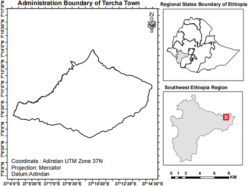
Tarcha town administration is situated in Dawro zone, Southwest Ethiopia Peoples Regional State. It is one among reform towns in the region.The town was located at a distance of 505 km away from Addis Abeba through Jimma road and 422 km through Wolaita Sodo-Chida road from Addis Abeba. The town shares boundaries with the following district’s from northwest Mareka district to southwest Genna Bossa and Mareka to the east GennaBossaworeda and to the South Mareka are boundary sharing woreda’s.Astronomically, Tarcha is located at 6°36’0’“up to 7 °21” 0” north latitude and 36 °68’0” to 37 °52’ 0” east longitude (Figure ). Tarcha experiences a tropical monsoon climate, characterized by a distinct wet and dry season. The mean annually temperature rate and mean annually rainfall of the study area are 30 degrees Celsius and 1401–1800 mm respectively (ENMA Ethiopian National Meteorological Agency, Citation2021). An altitude ranges from 935 m to 1700 m. The total administrative boundary of the town covers 11,467 hectares.
Figure 1. Location map of study area.
2.2. Methods
2.2.1. Research design
This study used a partially mixed sequential dominant status-quantitative or technical research design. This is because, as indicated by Powell et al. (Citation2008), quantitative, technical, and qualitative phases occur one after the other, with the quantitative/technical phase being given higher priority and mixing occurring at the data interpretation stage.
2.2.2. Data types and sources
The most important data for this research were soil type data, shuttle radar topography mission (SRTM) of 1 Arc-Second Global digital elevation model (DEM), Road network, slope, groundwater well point, drainage network, and land use land cover map of the study area. Primary and secondary sources were used to obtain the data (Table ). The high spatial resolution data of historical image was obtained from Google Earth Pro extension. The solid waste data and population of the town was obtained from secondary sources.
Table 1. Types and sources of data
2.2.3. Solid waste generation and urban expansion over the past 10 years
The urban population of Tercha Town for each year between 2014 and 2022, was calculated from the base year population of 15,458 at year 2013 with an annual population change of 6.7% (CSA Central Statistical Agency of Ethiopia, Citation2019). The total amount of household solid waste (HSW) produced by all houses in town is calculated according to Miezah et al. (Citation2015). The urbanization trend and the total amount of household solid waste data of the past 10 years were computed statistically to show strength of the variable’s relationships.
Where H/day is the Household solid waste generation kilogram per capita per day.
The spearman’s rank order correlation statistics approach was used for correlation coefficient computation. According to Algahtany and Kumar (Citation2016), Spearman’s rank order correlation is the best statistical approach because it is non parametric (distribution-free).
Where (di) is the difference between paired ranks, and (n) is the number of cases
2.2.4. Data analysis of factor maps
2.2.4.1. Slope
The 30 m spatial resolution SRTM was used to derive the slope map of the study area by using the spatial analyst tools (slope). After the preparation of the slope map, it was reclassified into four suitability classes: highly, moderately, less, and not suitable. The determination of the slope suitability class was based on the work of Ebistu and Minale (Citation2013a) and Ali Mohammed (Citation2016). According to their study, the slope class in percent < 10 is highly suitable,10–15 moderately suitable,15–20 less suitable, and > 20 not suitable.
2.2.4.2. Satellite image data preparation
To classify the images, ERDAS Imagine 2016 software was used. For better classification accuracy, band 9 of the panchromatic image, which had a spatial resolution of (15 m × 15 m) was merged with the other multispectral bands. The image was projected onto Adindan zone 37. Radiometric calibration was accomplished by applying dark object subtraction (DOS). The image classified in to four land use/cover classes through supervised classification techniques, and maximum likelihood algorithm namely: built-up, bare land, shrub land and agricultural lands. It classified with an overall accuracy of 93% and kappa coefficient of 0.94.
2.2.4.3. Soil types
The soil types, soil depths and soil textures data were obtained from FAO digital soil database (FAO, Citation2019). The physical characteristics of soil are among the significant criteria during the landfill site selection process. Therefore, the suitability level of each soil type was determined by its permeability and textural size. Hence, soils with low permeability and high clay content were selected as being highly suitable. Low-permeability soil can prevent polluted materials from passing through the ground and can control groundwater pollution. According to the Ministry of Urban Development and Construction (MUDC) (Citation2012), clay-textured soil is preferred for landfills because it is impermeable to leachate and is used for lining the base of sanitary landfills. Moreover, areas with deep soil are preferred, as they provide soil for covering solid waste after each disposal day to minimize air pollution from the landfill.
2.2.4.4. Analysis of road network
The road networks in the study area were digitized from aerial photographs of the town. Afterwards, a geo-processing technique, such as buffering, is performed for digitized road networks, and buffers of specified distances are created using literature values widely used in the landfill site selection process. After the buffering operation, it was converted into a raster format to prepare it for reclassification. According to (Ebistu & Minale, Citation2013a) 0-500 m,500-1000 m not suitable and less suitable,1000–1500 m and 15,000–2000 m are moderately suitable and highly suitable, respectively.
2.2.4.5. Analysis of drainage network
Perennial and intermittent rivers and streams in the study area were generated from the Shuttle Radar Topographic Mission (SRTM) DEM in the ArcGIS environment using Spatial Analysis tools. Preprocessing operations, such as sink filling, were performed in ArcMap using the hydrology tool. Buffering for streams and river networks at specified distances was created and reclassified according to their suitability level. Hence, buffering is based on the studies of MUDC (Citation2012) and Kabite (Citation2011). During the reclassification less than 300 m was unsuitable. A distance range greater than 1000 m is highly suitable. The distance ranges from 300-500 m and 500-1000 m less and are moderately suitable.
2.2.4.6. Proximity to borehole data
The proximity of a landfill to a groundwater well is an important environmental criterion for landfill site selection. Thus, wells may be protected from runoff and landfill leaching. The point data were buffered and converted into a raster format to match the other layers in this study. The raster format map was reclassified into suitability classes by referring to the literature. Hasan et al. (Citation2009) used 500- 1000 m and Jamjan (Citation2009) used 700 m as the minimum distance from which a landfill can be safely sited (Kabite, Citation2011). 0-500 m, 500-800 m, 800–1200, 1200–2000 m and >2000 m were prepared around each well point. In this study 0-500 m was Not suitable,500-1000 m was Less Suitable,1000–1500 Moderately Suitable, and >1500 m was Highly Suitable.
2.2.4.7. Analysis distance from settlement
This was performed to determine the distances from the settlement to the specific suitability classes. A proximity buffer of a specified distance was created to determine the minimum and maximum distances from disposal sites. After the proximity buffering operation, the data were converted into raster format. The converted raster format data were reclassified into suitability classes.
2.2.4.8. Multi-criteria evaluation methodology based on Weighted Linear Combination (WLC) and analytic hierarchy processes (AHP)
GIS-based multi-criteria decision analysis involves the utilization of geographical data, the decision-maker’s preferences, and a combination of the data and preferences according to specified decision rules (Malczewski, Citation2006). WLC and AHP are the two most well-known Multi-Criteria Analysis methods used in this study. After the reclassification process was applied to all the above criteria, they combined weighted overlay tools to find and prepare thematic maps showing highly suitable areas. None of the criteria considered in this study can have an equal degree of importance; therefore, the importance of each criterion relative to the other criteria was determined. The procedure by which the weights were produced followed the logic developed by Saaty (Citation1980) under the Analytical Hierarchy process (AHP). The weight rate was given based on a wise comparison with 9 point continuous scale (Table ). These pair-wise comparisons were performed to produce weights that sum to 1. Using IDRISI software, the weight module utilizes a pair-wise comparison technique to help develop a set of factor weights that sum to 1 according to Malczewski (Citation2000) equation
Table 2. Scale for pair wise comparison (Saaty, Citation1980)
Where s is suitability index for the area, w is the weight of criterion, y is the score of criterion, and i is the criterion.
3. Result and discussions
3.1. Solid waste generation and urban expansion over the past 10 years in Tercha town
Tercha Municipality does not have historical records of waste generation. It is difficult to obtain statistics on solid waste generation in terms of quantity and composition for all countries, including Ethiopia (Erasu et al., Citation2018). For this reason, to obtain historical data on Household solid waste generation (HSWG) kilogram per capita per day (kg/c/day) in Tercha town, similar studies on Ethiopian cities were reviewed. According to different studies (Assefa, Citation2017; Erasu et al., Citation2018; Fereja & Chemeda, Citation2021; Getahun et al., Citation2011; Goa & Sota, Citation2017) conducted in Ethiopian cities, the daily per capita solid waste generation for households ranges from 0.17 to 0.55 kg/capita/day. More specifically, a study conducted in 10 cities in Ethiopia found that the overall rate of solid waste generation rate was 0.32 kg/capita/day (Molla et al., Citation2015). Due to the similarity of studied cities demography and socioeconomic characteristics, a generation rate of 0.32 kg/capita/day was assumed for Tercha city. The total amount of household solid waste was calculated from this value (Table ). The population of Tercha city in the base year 2013 (15,458) was obtained from the Central Statistical Authority of Ethiopia (CSA Central Statistical Agency of Ethiopia, Citation2019). The estimated urban population of Tercha town for each year from 2014 to 2022 with an annual population change of 6.7%
Table 3. The solid waste generation and urban expansion (2013–2022)
The Spearman’s rank order correlation between Area and total solid waste is highly significant (rho = .997, p = .000). This indicates a strong positive relationship between the two variables, suggesting that as the area increases, so does the total solid waste. The correlation is significant at the 0.01 level, meaning that this relationship is unlikely to have occurred by chance (Table ). This finding is consistent with the common understanding that larger areas tend to have more population and economic activities, resulting in a greater production of solid waste.
Table 4. Spearman’s rank-order correlation test results
3.2. Analysis of land fill site selection criteria
To select suitable solid waste dumping sites for the study area, the following determinant factors were used: The analysis was based on the published and unpublished scientific literature.
3.2.1. The suitability class determination of land use/cover type
The land use/cover classification classes of suitability are considered to be two basic things. These are the values of the land and social effects. Based on these criteria, the land use/cover map of the study area was classified into four suitability classes: bare land as highly suitable, bush land as moderately suitable, agricultural land as less suitable, and built-up area not suitable.
3.2.2. The slope suitability class determinations
The slope can determine the possibility of groundwater contamination extent and area feasibility for construction in terms of cost. In this study, areas with high and extremely flat slopes were considered unsuitable for solid waste disposal. This is because when the area becomes steep, it may be vulnerable to erosion, resulting in the contamination of surface water through flooding. Moreover, the construction costs of excavation increase at higher slopes. However, a slope that is too flat is not recommended because of the water logging problem and groundwater pollution caused by the leaching of polluted materials. The determination of the slope suitability class was based on the work of Ebistu and Minale (Citation2013a) and Ali Mohammed (Citation2016). According to Table , the slope class < 10% is highly,10–15% moderately, 15–20% less,> 20 not suitable for landfill site selection.
Table 5. Suitability classes of slope (own processing)
As shown in the Table , 23.62 of the study area was found within slope range of less than 10%. However, the majority of the study area is found a slope range of > 20%, which is 37.56%, and the remaining area is found between 10–15% and 15–20% covering an area of 22.33 and 16.47 percent respectively.
3.2.3. The road network proximity analysis
Major roads were considered in the study area to measure the distance from a road to a specific suitability class. Distance plays an important role in the identification of suitable landfill sites. When the distance from the road increases, it results in increased transportation cost. According to Ebistu and Minale (Citation2013b), pp. 0–500,500–1000 Not suitable and Less suitable,1000–1500 and 1500–2000 Moderately suitable and Highly Suitable, respectively. Hence, areas within 500 m of roads were reclassified as unsuitable areas, 500–1000 m as suitable, 1000–1500 m as highly suitable, and 1500–3000 m as less suitable (Table ).
Table 6. Road suitability classes, area in Hectares and Percentage share
3.2.4. The drainage network proximity analysis
Landfill sites should not be constructed near the rivers or streams. This is because it leachates from the site and contaminates the surface and groundwater. The distance range of suitability classes was categorized into four classes. The distance range was based on the standards of the MUDC (Citation2012) and Kabite (Citation2011). According to their study, a distance of <300 m is Not suitable, > 1000 m is highly suitable, 300-500 m is less, and 500-1000 m is moderately suitable (Table ).
Table 7. Drainage suitability classes area in hectares and percentage share
3.2.5. The suitability classification of soil types
Soil type is a determining factor in the identification process of solid landfill site selection. As shown in Table , there were three types of soil in the study area. The identified soil types textural classes and depth data were extracted from FAO (Citation2019).
Table 8. Soil types textural classes and depth (FAO, Citation2019)
According to MUDC (Citation2012), the soil types that are preferable for solid waste land fill site selections are soils with low permeability and high clay content. This is because low-permeability soil can prevent polluted materials from passing through the ground and can control groundwater pollution. In addition to clay content, soil depth was also included in the suitability analysis. Deep soil is preferred because it provides soil for covering solid waste after each disposal day to minimize air pollution from the landfill. As shown in Table , orthicacrisols Dystricnitisols and eutriccambisols are classified as Highly, Moderately, and Less Suitable for landfill site selection, respectively.
Table 9. Suitability classes of soil types and depths (own processing)
3.2.6. Bore hole suitability analysis
The data from the six borehole points were buffered into four suitability classes. The buffered suitability class map was converted into raster format. The converted raster format data were reclassified into highly, moderately, less, and unsuitable classes. The proximity of a landfill to a groundwater well is an important environmental criterion in landfill site selection so that wells may be protected from the runoff and leaching of the landfill (Chang et al., Citation2008).
Based on Table , majority of the study area (78.93%) was highly suitable for solid waste dumping. The remaining 8.42% and 8.69 percent of the study area were less suitable and moderately suitable, respectively.
Table 10. Borehole suitability classes area in hectares and percentage share
3.2.7. Suitability analysis of settlement data
The landfill site should not be placed near a residential or urban area to protect the general public from possible environmental hazards released from landfill sites. If the site is near, it will adversely affect the land value and future development.
According in Table , the majority of the study areas (76.54%) were not suitable for solid waste dumping from residential area point of view. Conversely, 6.23% hectare of the study area was found to be highly suitable. The remaining 21.34% and 8.40% were found to be less suitable and moderately suitable, respectively.
Table 11. Settlement area suitability classes, area in hectares and percentage share
3.2.8. Lithology
The lower trachyte flows are characterized by stratified massive trachyte with rare pyroclastic and cool beds. Trachyte is characterized by very high permeability owing to a high degree of weathering and fracture (Sener et al., Citation2006). Light gray is often weathered, and when fresh, it is dark gray with secondary zeolite and primary sanidine, and these types of lithology are not suitable for landfill sites. Middle basalt flows are characterized by a low degree of weathering and fractures and are therefore described as impermeable rock. Therefore, middle basalt flows are highly suitable for landfill sites. As shown in the Table , the study area is covered by lower trachyte (TV3), which covers 71.1% of the study area, which is more in the northern part of the study area was not suitable, and the middle basalt (Tv5) covered 28.9% percent of the study area is Highly suitable.
Table 12. Lithology suitability classes area in hectare and percentage share
3.2.9. Fault
According to the standard, areas found within a 1000 m buffer distance from faults were considered unsuitable for solid waste disposal sites because of the high permeability of soil near the fault and keeping the groundwater contamination waste disposal area far from faults (Ali Mohammed, Citation2016). Distances from 0-1000 m are not suitable, and areas greater than 3000 m are highly suitable. The distance between 100-2000 m and 2000–3000 m were Less and moderately suitable, respectively (Table ).
Table 13. Suitability classes of fault area in hectare and percentage share
3.3. Assigning criteria weights using pair wise comparison matrix
After the reclassification process was applied to all the above criteria, they were combined using weighted overlay tools. None of the criteria considered in this study can have an equal degree of importance; therefore, the importance of each criterion relative to the other criteria was determined. This was performed to identify the influence of each factor relative to the other factors for solid waste dumping site selection. The weights for each criteria were determined based on a multi-criteria evaluation technique in the AHP procedure developed by Saaty (Citation1980). This method is capable of ranking choices according to their importance in meeting conflicting objectives and their ability to detect inconsistent judgments using the consistency ratio. Accordingly, in IDRISI Selva version 17, a pairwise comparison matrix was developed so that the weight for each criterion is equal to 1 (Kabite, Citation2011). The weights for each criterion were assigned based on various reviews and the prevailing local environmental conditions to prepare the matrix table. A matrix was constructed, where each criterion was compared with the other criteria relative to its importance on a scale from 1 to 9; the higher the weight, the more important the criterion (Table ). Each factor weight is calculated by comparing two factors at a time using a scale from 9 to 1/9. According to Saaty (Citation1980), a rating of nine indicates that the row factor is more important than the column factor. Based on the AHP weight derivation module, the following eigenvectors of weights for all factors considered for landfill site selection were generated:
Table 14. Criteria using pairwise comparison matrices,Engine vector weight and percentage
Consistence Ratio 0.06 < 0.1 is acceptable
The most important variables were identified after the pairwise comparison matrix (Table ). By combining the reclassified factor maps in the weighted overlay tool, a final suitability class map was prepared (Figure ).
Figure 2. The reclassified and suitability classes map.
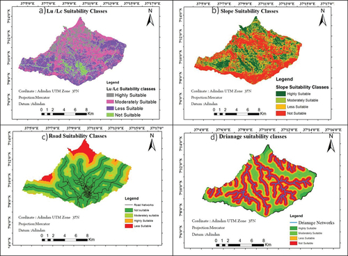
Figure 2. (Continued).
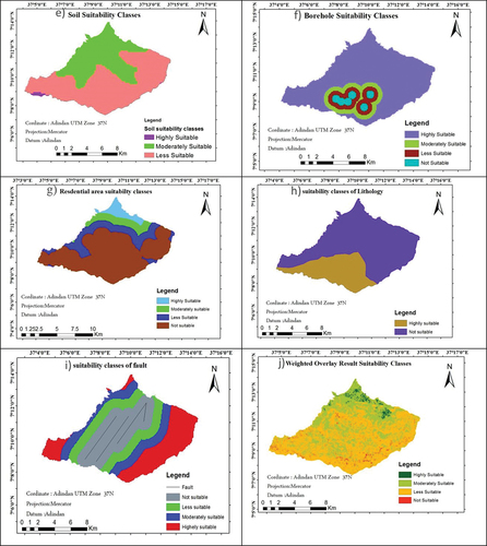
Table 15. Weighted overlay result
3.3.1. Thematic maps showing highly suitable sites
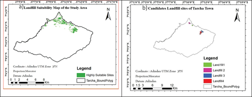
After preparing the weighted overlay suitability map, a thematic map showing the highly suitable sites was prepared (Figure ). To do so, highly suitable areas were first converted into a shape file using ArcGIS analysis (conversion) tools.
Figure 3. Highly suitable and candidate land fill area.
3.3.2. Prioritizing the selected highly suitable candidate sites
Highly suitable areas can also be prioritized based on criteria such as the size of the site, distance from the center of town c, and distance from the nearby settlement. According to (Kabite, Citation2011), the size of a landfill is one of the determinant criteria for sustainable solid waste management, as the size of the land selected for landfill determines the number of years for which the landfill will be used as a waste disposal site. Larger-sized landfills are preferable to smaller-sized landfills because large landfills can serve for at least 10 years and can minimize the cost of reconstructing landfills. Hence, sites <0.07 km2 were excluded from further analysis because they can be filled out within a few years of service and incur additional costs to reconstruct the sites (Table ). Consequently, the results of the analysis identified seven candidate landfills for further evaluation (Figure ).
Table 16. Analysis of candidate landfill sites with the previously used landfill siting criteria
As described in Table , the criteria conflict with one another. One criterion may be suitable from one dimension at the same time but may not be suitable in another dimension (e.g., distance from city center, distance from nearby settlement, and area in kilometer square). MCE solves such decision problems to choose the most suitable landfill sites by considering all three criteria at a time for the entire candidate landfill site. Therefore, using the MCE in the AHP procedure, weights for each contradicting criterion were derived.
Table 17. Comparison of candidate landfills based on distance from center, size and distance from settlement
Based on Table , a comparison matrix suitability analysis was performed for all candidate landfills in terms of their size, distance from settlement, and distance from the center.
Table 18. AHP weight derivation for evaluation criteria
As shown in Table , landfills were evaluated based on their size, distance from the center of the city, and distance from nearby settlements. Accordingly, landfills 4 and 3 were found to be the most suitable sites from a size point of view compared with other sites with eigenvector weights of 0.5576 and 0.2502, respectively. The analysis of landfills with distance from the center of the city point of view also reveals that landfill 4 with an eigenvector weight of 0.5576 is the most suitable site, whereas landfill 3 with an eigenvector of 0.2502 is the second most suitable site compared to other sites. From proximity to settlements, Landfill 3 and Landfill 1 eigenvectors are highly suitable sites. To solve such conflicting decisions in choosing the most suitable landfill site, all evaluation criteria were considered simultaneously in the MCE methods. Thus, the weights for all candidate landfills were derived by multiplying the criteria weight and landfill site weight, which were derived in relation to the criteria, and then summing the corresponding products.
Table 19. Comparison and weight calculation for each candidate landfill sites by their size and distance to the center
As shown in Table , landfills 4 and 3 were selected as highly suitable sites with eigenvector weights of 0.4760 and 0.2601, ranked first and second, respectively. In contrast, landfills 2 and 1 were found to be unsuitable according to the criteria considered and are the last option to be used as solid waste dumping sites.
Table 20. Weight score of the candidate sites and their rank
3.4. Discussions
The high correlation coefficient (rho = .997) suggests that there is a nearly perfect positive relationship between urban expansion and total solid waste. This finding is consistent with previous research that has shown a positive correlation between area and solid waste generation. A study conducted by Jones and Lomas (Citation2015) found a similar positive correlation between urban area size and waste generation rates in a sample of cities in the United States. Additionally, a study by Bai and Sutanto (Citation2002) found that larger areas tend to have higher population densities, which can increase the amount of waste generated. These findings suggest that as urban areas continue to expand, there is a need for effective waste management strategies to handle the increasing amounts of solid waste being produced.
Identifying a suitable site is no easy task without the technology of GIS. It is a challenging process that requires consideration of a number of factors (Asefa et al., Citation2021). In this study, the nine most important factors were identified and analysed to locate suitable landfill sites. The use of factors and suitability classes varies in different studies (Asefa et al., Citation2021; Debalke & Admas, Citation2021; Gelan, Citation2021; Hailu, Citation2019; Mihiretie, Citation2022; Sisay et al., Citation2020). In this study, criteria such as slope, land use/land cover, soil type, distance to settlement, distance to drainage, distance to road, borehole, lithology, and fault map were used to identify potentially suitable landfill sites. Factors for suitability were ranked by reviewing previously published literature. Each factor map except the suitability classes for soil and lithology were divided into four suitability class ranges namely highly suitable, moderately suitable, less suitable, and not suitable. However, the soil type suitability ranges were classified as highly suitable, moderately suitable, and not suitable. This classification was based on the permeability and clay content of the soil. Since there are only two lithology classes, two suitability classes were determined. The suitability classes indicate the factors that are suitable for landfill site selection.
The land use/land cover classification was based on land value and social effects. Bare land is classified as a highly suitable site for a landfill, assuming that it has poor land use, no occupants, and no cost for clearing. According to the report by Eskandari et al. (Citation2015), soil with poor land use and no residential population are the most suitable sites for landfills. Subsequently, with some clearing, cost the bush land was classified as moderately suitable. The agriculture and settlements categories are not possibly a choice to make landfill sites. Analysis of proximity to the road network was an important factor in finding landfill sites near roads. The greater the distance to the road, the higher the transportation costs. Nevertheless, a distance of less than 500 m is not suitable. Landfills located near roads can affect the health and aesthetics of the area. On the other hand, if it is far from the road, there will be higher costs for the construction of road infrastructure.
The slope classes from 0 to 10% were considered most suitable for landfill construction. This slope class is economically feasible and environmentally sound to minimise the impact of leachate. On the other hand, slope classes above 20% are considered unsuitable due to construction costs and erosion effects. Higher elevated areas are unsuitable for locating landfills, this is to avoid construction expenses (Makonyo & Msabi, Citation2021). The landfill should not be located near boreholes, rivers and streams to minimise the leaching effect. If the landfill is located near the borehole, river or stream, it could affect the ecosystem of the river and human and animal life. In similar studies conducted by Mussa and Suryabhagavan (Citation2019) in the city of Logia, the solid waste dumped near the river caused ecological, agricultural and health problems. The boreholes near the landfills had higher TDS (Total Dissolved Solids) values than the limit prescribed by the standard WHO (500 mg/l) (Mekonnen et al., Citation2020). Surface water samples also had sulphate concentrations that were within the allowable limits in both seasons (Ololade et al., Citation2019).
The suitability increases as the distance increases from the borehole, rivers, and streams. Lithology and faults are important factors in selecting landfill sites for solid waste. A distance of more than 1000 m was deemed highly suitable for solid waste landfills, aiming to reduce groundwater contamination and the permeability of soil near fault lines. A similar study conducted by Mussa and Suryabhagavan (Citation2019) found that the further the fault, the more suitable the area for waste disposal, thus mitigating the adverse effects of dumpsites. Additionally, lithology with higher permeability speeds up the infiltration process, making it unsuitable for landfill locations ((Makonyo & Msabi, Citation2021).
The orthoc acrisols, which have an average clay content of 35.6% and a soil depth of more than 120 cm, were selected as a particularly suitable site for landfilling. Due to the dominance of stable clays with low activity and the general lack of bases, this is a very suitable soil type (ISRIC, Citation2022). A depth greater than 120 cm helps to reduce the effects of leachate. The thicker the soil, the more suitable it is for landfill construction (Eskandari et al., Citation2015). According to Sharma et al. (Citation2018), the effect of leachate on soil decreases with depth, which is reflected in the variation of concentration. The Eutric cambisols are not considered suitable at this time. They are located on a steep slope in the study area. Dumping on steep slope results in higher hydraulic conductivity, high pH, TDS, and high electrical conductivity (EC) (Ali et al., Citation2014; Sharma et al., Citation2018). This could increase agricultural and stream infiltration by altering the engineering properties of the soil. In terms of soil depth, it is shallower than the rest of soil types. To avoid the speedy leachate to the ground water, this soil type was classified as not suitable.
4. Conclusion
Selection of suitable sites for solid waste dumping is a complex task that requires careful consideration of many environmental and socioeconomic factors. Therefore, the application of GIS and remote sensing data is crucial for identifying potential solid waste dumping sites. This study was conducted to assess the potential suitable sites for solid waste dumping in Tercha City by considering physical and socio-economic factors using GIS and remote sensing techniques. The study also used a multi-criteria evaluation method to assign weights to all criteria considered and to handle large and conflicting criteria in landfill site selection processes. The final suitability map showed that 1.9% of the study area was highly suitable for landfills. Moreover, 34.91%, 60.12%, and 3% of the total area were moderately suitable, poorly suitable, and unsuitable, respectively. The final result showed that Landfill 4 with an eigenvector weight of 0.04670 and Landfill 3 with an eigenvector weight of 0.02601 were found to be the two most highly suitable sites.
GIS and remote sensing data can greatly assist in the selection of suitable sites for solid waste dumping. By considering both environmental and socioeconomic factors, this approach can help ensure that the chosen sites minimize negative impacts on both the natural environment and the human population. The multi-criteria evaluation method used in this study also allows for a systematic and objective decision-making process, taking into account the different weightings assigned to each criterion. This approach can help policy-makers make informed decisions regarding landfill site selection, considering not only physical factors but also social and economic aspects. Additionally, the use of GIS spatial analysis tools enables the visualization and integration of geographical data, facilitating a comprehensive assessment of potential sites. By utilizing this method, policy-makers can identify the most suitable sites for landfill development, allocating resources effectively and minimizing potential environmental and socioeconomic risks. The study was limited to using literature for estimating historical solid waste generation from households and lacked the cost estimation of constructing suitable waste disposal sites. However, further research could be done in assessing the current solid waste generation rate and predicting the amount in relation to changing urban land use for future development.
Disclosure statement
No potential conflict of interest was reported by the author(s).
Additional information
Notes on contributors

Firehiywet Girma
Firehiywet Girma is a committed researcher and lecturer at Wondo Genet College of Forestry and Natural Resource Management, Hawassa University. He specializes in Geographic Information System and remote sensing. Over the past five years, he has taught various courses on GIS and RS. His research interests revolve around time series data analysis, spatial planning, spatial modeling, and network data analysis. Currently, he is conducting a Nexus study on the interrelationships between ecosystem services, climate change, and land use and land cover dynamics in Sidama Regional State.
Betelihem Teshome
Betelihem Teshome graduated from Mekelle University, College of Social Science and Languages with a Bachelor of Science degree in Geography and Environmental Studies. She then specialized in a Master of Science degree in GIS and RS at Jimma University. Currently, she serves as a higher expert in Urban Land Registration and vice head of the Urban Development Bureau in the Southwest Regional State. In her role, she is involved in structural planning, Urban Land Registration and Cadaster, and street addressing in various regional cities.
References
- Abdel-Shafy, H. I., & Mansour, M. S. (2018, December). Solid waste issue: Sources, composition, disposal, recycling, and valorization. Egyptian Journal of Petroleum, 27(4), 1275–20. https://doi.org/10.1016/j.ejpe.2018.07.003
- Algahtany, M., & Kumar, L. (2016). A method for exploring the link between urban area expansion over time and the opportunity for crime in Saudi Arabia. Remote Sensing, 8(10), 863. https://doi.org/10.3390/rs8100863
- Ali Mohammed, A.,(2016). GIS and remote sensing based suitable site selection for solid waste disposal: a case study of Asaita town, afar regional state [ Ethiopia unpublished thesis] Addis Ababa University Ethiopia
- Ali, S. M., Pervaiz, A., Afzal, B., Hamid, N., & Yasmin, A. (2014, January). Open dumping of municipal solid waste and its hazardous impacts on soil and vegetation diversity at waste dumping sites of Islamabad city. Journal of King Saud University - Science, 26(1), 59–65. https://doi.org/10.1016/j.jksus.2013.08.003
- Ambaneh, M. (2016, June 1). Solid waste disposal site selection using gis and remote sensing: For Mojo town, Ethiopia. Retrieved April 9, 2023, from http://etd.aau.edu.et/handle/123456789/5689
- Asefa, E. M., Damtew, Y. T., & Barasa, K. B. (2021, January). Landfill site selection using GIS based multicriteria evaluation technique in Harar city, Eastern Ethiopia. Environmental Health Insights, 15, 117863022110531. https://doi.org/10.1177/11786302211053174
- Assefa, M. (2017). Solid waste generation rate and characterization study for Laga Tafo Laga Dadi town, Oromia, Ethiopia. International Journal of Environmental Protection and Policy, 5(6), 84. https://doi.org/10.11648/j.ijepp.20170506.11
- Bai, R., & Sutanto, M. (2002). The practice and challenges of solid waste management in Singapore. Waste Management, 22(5), 557–567. https://doi.org/10.1016/S0956-053X(02)00014-4
- Berisaand, G., & Birhanu, Y. (2015). Municipal solid waste disposal site selection of JigjigaTown using GIS and remote sensing techniques,Ethiopia. International Journal of Scientific and Research Publications, 5(4), 1–17. 2250–3153.
- Bhada-Tata, P., Hoornweg, D., & Van Der Woerd, F. (2012). What a waste: A global review of solid waste management. The World Bank.
- Birke, Y. (1999). Integrated development for water supply and sanitation 25th WEDC vonference. Addis Ababa.
- Chang, N., Parvathinathanb, G., & Breden, J. B. (2008). Combining GIS with fuzzy multi criteria decision making for landfill sitting in a fast-growing urban region. Journal of Environmental Management, 87(1), no 139–153. https://doi.org/10.1016/j.jenvman.2007.01.011
- CSA (Central Statistical Agency of Ethiopia). (2019). Tarcha zone socio-Demographic & economic Profile.
- Debalke, D., & Admas, T. (2021, November). Solid waste dumping site analysis using GIS and remote sensing: Bonga Town, Southwestern Ethiopia. Waste Management & Research: The Journal for a Sustainable Circular Economy, 40(7), 953–968. https://doi.org/10.1177/0734242x211060608
- Ebistu, T. A., & Minale, A. S. (2013a). Solid waste dumping site suitability analysis using Geographic information System (GIS) and remote sensing for Bahir Dar town, Ethiopia. African Journal of Environmental Science and Technology, 7(11), 976–989. https://doi.org/10.5897/AJEST2013.1589
- Ebistu, T. A., & Minale, A. S. (2013b). Solid waste dumping site suitability analysis using geographic information system (Gis)and remote sensing for Bahir Dar town, North Western Ethiopia. Journal of African Journal of Environmental Science and Technology, 7(11), 977–989.
- ENMA (Ethiopian National Meteorological Agency). (2021). Climate data user Guide – 1981-2010 climatology. http://www.ethiomet.gov.et/Document/“Climate_Data_User_Guide_1981_2010_Climatology”.pdf
- Erasu, D., Feye, T., Kiros, A., & Balew, A. (2018, July 11). Municipal solid waste generation and disposal in robe town, Ethiopia. Journal of the Air & Waste Management Association, 68(12), 1391–1397. https://doi.org/10.1080/10962247.2018.1467351
- Eskandari, M., Homaee, M., Mahmoodi, S., Pazira, E., & Van Genuchten, M. T. (2015, February 11). Optimizing landfill site selection by using land classification maps. Environmental Science and Pollution Research, 22(10), 7754–7765. https://doi.org/10.1007/s11356-015-4182-7
- FAO. (2019). Digital soil database. Food and Agriculture Organization of the United Nations. http://www.fao.org/soils-portal/soil-survey/soil-maps-and-databases/digital-soil-database/en/
- Fatimah, Y. A., Govindan, K., Murniningsih, R., & Setiawan, A. (2020, October). Industry 4.0 based sustainable circular economy approach for smart waste management system to achieve sustainable development goals: A case study of Indonesia. Journal of Cleaner Production, 269, 122263. https://doi.org/10.1016/j.jclepro.2020.122263
- Fereja, W. M., & Chemeda, D. D. (2021, September). Status, characterization, and quantification of municipal solid waste as a measure towards effective solid waste management: The case of Dilla town, Southern Ethiopia. Journal of the Air & Waste Management Association, 72(2), 187–201. https://doi.org/10.1080/10962247.2021.1923585
- Gedefaw, M. (2015). Assessing the current status of solid waste management of Gondar town, Ethiopia. International Journal of Scientific and Technology Research, 4(9), 1–36. 2277–8616.
- Gelan, E. (2021, July 11). Municipal solid waste management practices for achieving green architecture concepts in Addis Ababa, Ethiopia. Technologies, 9(3), 48. https://doi.org/10.3390/technologies9030048
- Getahun, T., Mengistie, E., Haddis, A., Wasie, F., Alemayehu, E., Dadi, D., Van Gerven, T., & Van der Bruggen, B. (2011, October). Municipal solid waste generation in growing urban areas in Africa: Current practices and relation to socioeconomic factors in Jimma, Ethiopia. Environmental Monitoring and Assessment, 184(10), 6337–6345. https://doi.org/10.1007/s10661-011-2423-x
- Goa, E., & Sota, S. S. (2017, May 18). Generation rate and physical composition of solid waste in Wolaita Sodo town, southern Ethiopia. Ethiopian Journal of Environmental Studies and Management, 10(3), 415. https://doi.org/10.4314/ejesm.v10i3.11
- Hailu, Y. (2019, July 30). Municipal solid waste suitable disposal site selection, case study, Wolkite town, Ethiopia. International Journal of Environmental Sciences & Natural Resources, 20(4). https://doi.org/10.19080/ijesnr.2019.20.556044
- Hammer, G. (2003) Solid waste treatment and disposal: Effects on public health and environmental safety.
- Hasan, R. M., Tetsuo, K., & Islam, A. S. (2009). Landfill demand and allocation for municipal solid waste disposal in Dhaka city-an assessment in a GIS environment. Journal of Civil Engineering, 37(4), 133–149.
- Haywood, L. K., Kapwata, T., Oelofse, S., Breetzke, G., & Wright, C. Y. (2021, August 2). Waste disposal practices in low-income settlements of South Africa. International Journal of Environmental Research and Public Health, 18(15), 8176. https://doi.org/10.3390/ijerph18158176
- Hirpe, L., & Yeom, C. (2021, October 12). Municipal solid waste management Policies, practices, and challenges in Ethiopia: A systematic review. Sustainability, 13(20), 11241. https://doi.org/10.3390/su132011241
- ISRIC. (. 2022). World soil information. International soil reference and information centre. https://www.isric.org/
- Jamjan, J., (2009). Selection of a potential solid waste landfill site in Nakhon Pathom province by using Geographic Information System (GIS). MSc Thesis, Mahidol University, pp124.
- Jones, R. V., & Lomas, K. J. (2015, August). Determinants of high electrical energy demand in UK homes: Socio-economic and dwelling characteristics. Energy and Buildings, 101, 24–34. https://doi.org/10.1016/j.enbuild.2015.04.052
- Kabite, G., (2011). GIS and Remote Sensing based solid waste landfill site selection: a case of Addis Ababa City, Ethiopia. Unpublished master thesis at Addis Ababa University,
- Khatri, N., & Tyagi, S. (2014, September). Influences of natural and anthropogenic factors on surface and groundwater quality in rural and urban areas. Frontiers in Life Science, 8(1), 23–39. https://doi.org/10.1080/21553769.2014.933716
- Linda, A., Giday, K., Jamidu, H. Y., Suzan, O., Henning, U., & Yonli. (2020, August 19). Solid waste management in Africa: Governance failure or development opportunity? https://doi.org/10.5772/intechopen.78853
- Lohri, C. R., Camenzind, E. J., Zurbrügg, C., & Diener, S. (2018). Comparing informal urban waste management systems in east African cities. Waste Management, 71(1), 242–254. https://doi.org/10.1016/j.wasman.2013.10.014
- Makonyo, M., & Msabi, M. M. (2021, March). Potential landfill sites selection using GIS-based multi-criteria decision analysis in Dodoma capital city, central Tanzania. GeoJournal, 87(4), 2903–2933. https://doi.org/10.1007/s10708-021-10414-5
- Malczewski, J. (2000, January). On the use of weighted linear combination method in GIS: Common and best practice approaches. Transactions in GIS, 4(1), 5–22. https://doi.org/10.1111/1467-9671.00035
- Malczewski, J. (2006). GIS and multi-criteria decision analysis. John Wiley and Sons, Inc.
- Mekonnen, B., Haddis, A., & Zeine, W. (2020, June 8). Assessment of the effect of solid waste dump site on surrounding soil and river water quality in Tepi town, Southwest Ethiopia. Journal of Environmental and Public Health, 2020, 1–9. https://doi.org/10.1155/2020/5157046
- Miezah, K., ObrDanso, K., Kadar, Z., FeiBaffoe, B., & Mensah, M. Y. (2015). Municipal solid waste characterization and quantification as a measure towards effective waste management in Ghana. Waste Management, 46(1527), 15–27. https://doi.org/10.1016/j.wasman.2015.09.009
- Mihiretie, A. (2022, June 2). Suitable solid waste disposal site selection using geographical information System: A case of Debre Markos Town, Ethiopia. International Journal of Environment & Geoinformatics, 9(2), 1–8. https://doi.org/10.30897/ijegeo.784087
- Molla, A., Abegaz, T., & Hailu, D. (2015). Solid waste generation rate and characterization study for 10 towns in Ethiopia. Retrieved July 7, 2021, from https://www.researchgate.net/publication/327721072_Solid_Waste_Generation_Rate_and_Characterization_study_for_10_towns_in_Ethiopia
- MUDC. (2012). Solid waste management Manual, with respect to urban Plans, sanitary landfill sites and solid waste management planning.
- Mulugetta, Y., Sonnemann, G., & Spiegel, H. (2014). Urban solid waste management in developing countries: Balancing environmental, economic, and social priorities. Sustainability, 6(12), 8839–8861.
- Mussa, A., & Suryabhagavan, K. V. (2019, December). Solid waste dumping site selection using GIS-based multi-criteria spatial modeling: A case study in Logia town, Afar region, Ethiopia. Geology, Ecology & Landscapes, 5(3), 186–198. https://doi.org/10.1080/24749508.2019.1703311
- Naibbi, A. I., & Umar, U. M. (2017). An Appraisal of spatial Distribution of solid waste disposal sites in Kano Metropolis, Nigeria. Journal of Geoscience and Environment Protection, 05(11), 24–36. https://doi.org/10.4236/gep.2017.511003
- Nathanson, J. A. (2023). Solid-waste management. Encyclopedia Britannica. https://www.britannica.com/technology/solid-waste-management
- Ololade, O. O., Mavimbela, S., Oke, S. A., & Makhadi, R. (2019, August 6). Impact of leachate from Northern landfill site in Bloemfontein on water and soil quality: Implications for water and food security. Sustainability, 11(15), 4238. https://doi.org/10.3390/su11154238
- Powell, H., Mihalas, S., Onwuegbuzie, A. J., Suldo, S., & Daley, C. E. (2008). Mixed methods research in school psychology: A mixed methods investigation of trends in the literature. Psychology in the Schools, 45(4), 291–309. https://doi.org/10.1002/pits.20296
- Ram, P. (2021). An association of radiological and MRI findings in knee osteoarthritis patients with pain versus without pain of knee. International Journal of Recent Scientific Research, 12(4), 41520–41524. https://doi.org/10.24327/ijrsr.2021.1204.5907
- Saaty, T. L. (1980). The analytic hierarchy process. McGraw Hill.
- Sega, T. (2022, July 1). Solid Waste Disposal Site Selection Using Integrated Multi-Parametric AHP and GIS Techniques: The Case of Gish Abay Town, Ethiopia. http://ir.bdu.edu.et/handle/123456789/14472
- Sener, B., Su¨zen, M. L., & Doyuran, V. (2006). Landfill site selection by using geographic information systems. Environmental Geology, 49(3), 376–388. https://doi.org/10.1007/s00254-005-0075-2
- Sharma, A., Gupta, A. K., & Ganguly, R. (2018, August). Impact of open dumping of municipal solid waste on soil properties in mountainous region. Journal of Rock Mechanics and Geotechnical Engineering, 10(4), 725–739. https://doi.org/10.1016/j.jrmge.2017.12.009
- Sisay, G., Gebre, S. L., & Getahun, K. (2020, May). GIS-based potential landfill site selection using MCDM-AHP modeling of Gondar town, Ethiopia. African Geographical Review, 40(2), 105–124. https://doi.org/10.1080/19376812.2020.1770105
- UN-Habitat. (2018). SOLID WASTE MANAGEMENT in CITIES. United Nations Human Settlements Programme.
- Wang, Y., Li, J., An, D., Xi, B., Tang, J., Wang, Y., & Yang, Y. (2018, November). Site selection for municipal solid waste landfill considering environmental health risks. Resources, Conservation and Recycling, 138, 40–46. https://doi.org/10.1016/j.resconrec.2018.07.008
- World Bank Blogs. (2020). World Bank blogs. Retrieved April 9, 2023, from https://blogs.worldbank.org/team/abebaw-alemayehu
- Zhou, J., Li, L., Wang, Q., Van Fan, Y., Liu, X., Klemeš, J. J., Wang, X., Tong, Y. W., & Jiang, P. (2022). Household waste management in Singapore and Shanghai: Experiences, challenges and opportunities from the perspective of emerging megacities. Waste Management, 144, 221–232. https://doi.org/10.1016/j.wasman.2022.03.029
- Zorica, B., Valentina, E., & Cezarina. (2010, July 19). Waste management practices used in the attempt to protect the Environment. 378–382.
