Abstract
Although an ability to comprehend complex spatial-temporal relationships is central to understanding many aspects of GEES disciplines, students regularly struggle to fully appreciate the significance of such relationships in part because traditional teaching techniques do not graphically convey 3D and 4D relationships effectively. The development and deployment of a series of computer-generated simulations and video-based animations as part of a second year undergraduate sedimentology course within a Geology degree programme has been effective in addressing these issues. Implementation of these resources within a series of student-led practical exercises and self-learning revision tools is shown to be a powerful teaching tool for demonstrating how large scale sedimentary environments evolve over space and time and how their deposits become preserved in the rock record. Undergraduate performances in class tests show the beneficial impact these resources are having in improving student understanding and the quality of the learning experience.
Introduction
The ability to visualize and understand complex spatial and temporal relationships is an essential skill for students of earth sciences and related disciplines. Yet many students struggle to develop a deep appreciation for the significance of such relationships and, as such, their ability to comprehend and effectively explain many core earth science concepts is limited (CitationRaia, 2005; Taylor et al., 2004). For example, students commonly find introductory geological mapping courses problematic because they struggle to visualize map-based information as cross sections (CitationIshikawa & Kastens, 2005). In many cases, such problems occur not because of a lack of ability on the part of the student but rather because tutors lack effective tools with which to demonstrate complex 3D and 4D spatial and temporal relationships. Recent advances in computer animation software mean that many types of geoscience data can now be portrayed graphically as dynamic videos rather than static images and the provision of such tools is enabling educators in GEES subject areas to convey the significance of complex 3D and 4D relationships in a more effective manner than has hitherto been possible (CitationDurbin, 2002).
This article demonstrates how a series of student-led practical exercises, built around computer animations, has been devised and implemented within a second year undergraduate sedimentology course, with the aim of enhancing student comprehension of spatial and temporal complexities inherent in the long term behaviour and evolution of common sedimentary environments such as meandering rivers, deltas and aeolian dune fields. Specific objectives are: (i) to explain why students commonly experience difficulty in understanding dynamic system behaviour in sedimentology, (ii) to demonstrate how computer animations can enhance student awareness and comprehension in this area, (iii) to explain how such animations can be developed with relative ease using standard software applications, (iv) to show how practical exercises based around such techniques are relevant to broader learning and teaching strategies and (v) to demonstrate the value added to the student learning experience through implementation of such techniques.
Why use computer animations in sedimentology?
Courses in sedimentology and sedimentary environments are an integral part of most earth science and related degree programmes. One common approach to teaching sedimentary environments is to introduce examples of modern systems at a large scale (e.g. by using satellite images or aerial photos) and then to account for their sedimentary character (facies) at the small scale. From a student perspective, problems of comprehension most commonly occur when tutors attempt to explain how to recognise the deposits of such environments preserved in the ancient record, chiefly because the large-scale geometry of deposits in the subsurface does not typically bare much resemblance to the morphology of their modern counterparts. For example, in the vast majority of cases, preserved aeolian dune deposits form tabular (sheet-like) or trough-shaped packages of strata that have a very different shape to the ‘tent-like’ bedforms from which they were created. Similarly, meandering rivers deposit predominantly via lateral accretion over time (rather like the sideways movement of a snake) and, in doing so, typically accumulate extensive sheets of sand in which the form of the original channel is not usually discernable. Furthermore, the preserved geometries of aeolian dune or meandering river elements appear very different depending on which orientation they are viewed from and their recognition in outcrop is not straightforward. These simple examples highlight some of the spatial and temporal complexity inherent in the evolution and preservation of these systems; complexity that is difficult for tutors to convey to students using traditional, static presentation tools such as photos or line-art figures.
By contrast, dynamic computer animations are far better suited to conveying the complex nature of the evolution and preservation of such sedimentary environments because: (i) they enable the portrayal of complex 3D geometrical arrangements of bodies of strata (so-called architectural elements) and their visualization from different angles, such that spatial relationships between neighbouring elements can be established, (ii) they allow appreciation of the relative timing of the development of these various elements, such that a sequence of formative events can be established, (iii) by using zoom techniques, the fine detail and complexity inherent in sedimentary systems at a small scale can be related to the large scale architecture, and (iv) they enable the intrinsic behaviour of sedimentary systems — for example, the periodic cut-off of meander loops in sinuous rivers or the switching of lobes within deltas — to be more readily discerned from extrinsic controls such as climate or sea level change. In addition, animations allow multiple media types to be mixed together in an integrated manner that would not be possible with other presentation styles; video, line art, outcrop photos, aerial photos, satellite imagery and computer simulations can all be edited together with titles and an audio overdub, so as to present a coherent explanation.
The ability to visualize geological problems in three- and four-dimensions is a threshold concept — a fundamental skill that leads the learner to a previously unknown and inaccessible way of thinking (CitationStokes et al., 2007). In this regard, animations can change the way students perceive their discipline so that topics that are conceptually difficult to grasp are explained in a more accessible way and once learned this new understanding is unlikely to be forgotten (CitationCousin; Meyer and Land, 2006).
Development, production and delivery
A series of video resources has been developed and produced for sedimentology courses taught at Keele and Leeds universities using a range of standard software applications and associated hardware, an example of which is shown in . The author had no specialist skills in video production prior to commencing the work, though grounding in the theory of computer graphics proved useful. Video footage of a range of modern sedimentary environments and ancient outcrops was captured on a digital camcorder. Audio was recorded on a digital sound recorder via a semi-professional microphone. Video editing was performed on a standard PC with a dedicated video capture card installed to speed up the process. The development workflow () utilised a range of Adobe software including Illustrator and Photoshop for the preparation of still graphics, After Effects for video compositing and the production of animations (), Premiere for editing of digital video footage and its integration with animations, Audition for the editing of audio, Encore for output of finished productions to a range of formats, Dreamweaver for website design and Acrobat/Designer for the development of interactive forms used within the practical exercises.
Figure 1 Screen grab from a video-based practical exercise exploring the temporal evolution and spatial complexity of deltas
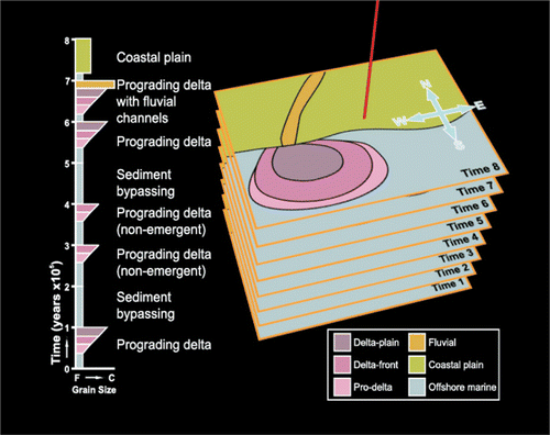
Figure 2 Simplified workflow used for the editing and production of digital video films within the project. “DW’er” is DreamWeaver web site development software. “Acrobat” is Adobe Acrobat and Adobe Designer. (MPG = Mpeg Video File, WMV = Windows Media Video, DV-AVI = Uncompressed Video File)
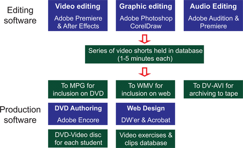
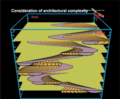
Figure 3 Adobe After Effects software was used to produce the computer graphic animations, including this 3D representation of a meandering river system and its preserved deposits.
A series of 11 short films ranging in duration from 7 to 25 minutes were produced, each dealing with a specific aspect of dynamic sedimentological behaviour. These were produced in a variety of formats with different end-purposes in mind. Firstly, each film was broken down into a series of short clips produced as high-resolution Audio-Video Interleave (AVI) files for use by lecturing staff to augment lecture and practical class teaching through seamless incorporation into PowerPoint presentations. Secondly, in a trade-off between file size and video quality, highly compressed versions of the videos were produced in Windows Media Video (WMV) format for delivery and dissemination over the internet via university-based Virtual Learning Environments (Blackboard and Web-CT). This proved to be a viable and efficient means of delivery to relatively large (50–130) student classes, with modest files sizes of ~2Mb per minute of footage. Finally, delivery of high quality versions of the videos was also explored whereby DVD-Video discs (produced at a unit cost of ~£2.00 by an external disc replication company) were lent to students for the duration of the taught module.
Relevance to learning and teaching strategy
The provision of a suite of video-based tools fulfils a number of requirements for improving learning and teaching experiences. From a basic pedagogic perspective, the video clips encourage the development of student independent learning skills whereby individuals can receive training in a setting of their choice and at a pace to suit their learning style. Importantly, these resources encourage student engagement with e-learning, which is now well established in most Higher Education institutions as an effective mechanism for knowledge transfer in large group and distance learning settings (CitationHEFCE, 2005, 2009). Because e-learning allows resources to be made available in a variety of digital formats (including video), it fulfils the expectations of the current generation of students for whom the assimilation of information from multimedia sources through, for example, the world-wide-web is an everyday activity (CitationOblinger and Oblinger, 2005). Further, these resources actively link research and teaching to benefit student learning (CitationHealey, 2005); they provide an efficient method to deliver a quality learning experience to large class sizes (CitationFrance & Fletcher, 2007); and they provide a means to reinforce core ideas by approaching concepts from a different perspective and, in doing so, they promote reflective thinking (CitationJohnson, 2002).
At a deeper pedagogic level, this project has developed a series of practical exercises based around the use of digital video for the observation of natural phenomena that cannot be witnessed first-hand (e.g. landslides, catastrophic floods, time-lapsed footage of sediment transport). In their simplest incarnation, these practical exercises involve students watching video clips before answering a series of questions based around the events therein. However, a more sophisticated approach has also been used whereby video exercises form part of a broader e-learning experience. In order to complete set practical exercises, students work through a series of questions that require examination of video clips to develop an understanding of core concepts within the subject area being investigated. Graphical web pages act as a means to navigate to various video resources that are each visited in turn within the practical session. This concept is best explained further by reference to a specific example. One practical session that has been developed is based around the examination of desert processes and environments. The session commences with students being introduced to a generic desert environment in which typical features such as sand dunes, desert lakes and flash-flood river systems are depicted graphically (). These various elements of the desert system act as pointers which encourage students to explore specific parts of the system in more detail, whereupon a variety of digital video clips are launched. Importantly, video clips are supplemented with other related digital media such as still images and computer simulations. Students gather information from these resources in order to answer a series of questions posed within the practical exercise.
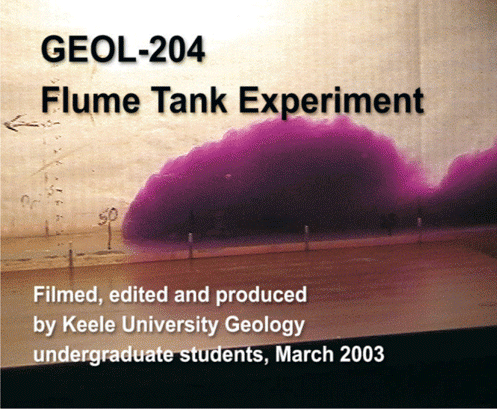
Another use of the video technology that has been implemented in sedimentology classes has been to encourage student-led experimental research through the implementation of a series of physical experiments that make use of digital video as an investigative tool. For example, a standard experimental apparatus within many sedimentological laboratories is a flume tank, which is typically used to make observations concerning the behaviour of fluid flows and resultant sediment transport. While student-led flume tank experiments yield valuable results, direct observations of the processes at work are often limited. The learning value of practical experiments utilising flume apparatus can be significantly enhanced by offering students the opportunity to shoot their own video footage and process it using specialist video editing software. Students can then analyse their data (for example by implementing time-lapse video techniques) and subsequently interpret the results in a manner that would otherwise not have been possible (). The pedagogic value of such an approach is to enhance skills in experimental design, to promote critical awareness and understanding of physical properties, to encourage independent learning, and to force students to critically evaluate their own methodologies. Furthermore, this approach also encourages active group learning and enriches teaching with discipline-specific research.
These video-based learning exercises are currently being employed in a variety of settings: (i) within established practical classes, (ii) as supplementary student-led learning exercises delivered as part of an existing course, (iii) through a module web site and via a Virtual Learning Environment as a series of revision exercises, and (iv) as part of both formative and summative practical tests. In addition to providing a novel method of assessment, the implementation of these resources is also helping to develop independent learning skills in students and to promote active learning in large group teaching settings.
Evaluation
The benefits of implementing these video-based resources within a taught sedimentology course have been dramatic and are best shown through analysis of results from an in-class practical test which formed 25% of the Second Year Sedimentology module taught as part of the Geology degree programme at Keele University. The questions posed in this annual test were the same for successive cohorts of students for the period 2002–2007. The video-based learning aids discussed herein were available to students as revision aids in 2005–2007. For the first part of the test, in which students were asked to interpret a series of thin section micrographs of sedimentary rocks, the video-based revision aids were not relevant and mean scores over the six-year period were 58, 57, 61, 60, 57 and 59%, indicating that student ability in this task had remained fairly constant year-onyear. By contrast, for the second part of the test, in which students were asked to interpret the spatial and temporal evolution of a series of sedimentary environments, the video-based resources (available from 2005 onwards) were directly relevant and students were encouraged to make use of them as revision aids. Mean scores for this part of the test prior to the introduction of the video resources were 57, 59 and 58%, whereas the scores for answers to the same questions after their introduction were 65, 67 and 64%, on average over 7% higher. These improvements are similar to those documented by other practitioners of this approach (e.g. CitationBoundy & Condit, 2004; Jain & Getis, 2003). The only significant change in the delivery of this course over the six year period was the implementation of the video resources in 2005.
Figure 4 A screen grab from a video of a flume tank experiment run by Keele University Geology undergraduates. Students edited the footage and used it to work out initial flow velocities and rates of deceleration for a range of density currents.
The effectiveness of the video-based exercises as a learning tool in this module is also demonstrated by qualitative data obtained from student evaluation questionnaires in which 95% of respondents (n = 145 over a 3 year period) agreed that the video-based resources had been either “beneficial” or “highly beneficial” to their understanding of the course subject matter. Many of the students questioned commented that the video resources improved their ability to visualise complex three- and four-dimensional problems and this is effectively summarized by the following two quotes from student feedback questionnaires.
“I was struggling to understand the concept of [delta] lobe switching and how this generated the complicated sedimentary architectures preserved in the rock record until I watched the video tutorials. The graphical 3D models… helped me to see how the various processes operate together”.
“The video tools were excellent. I now understand why the deposits of meandering river channels produce sheets of sandstone, rather than isolated channel shapes.”
Conclusions
Implementation of a series of video-based learning exercises has significantly improved student understanding of core concepts relating to the spatial and temporal evolution of large scale sedimentary environments taught as part of a second year sedimentology course in an undergraduate Geology degree programme. The resources were developed by the course tutor, who had only modest prior experience in video editing, using a standard suite of graphics software. Dissemination of the completed video-based exercises and revision aids was principally via a University Virtual Learning Environment, though delivery of higher-resolution versions on low cost DVD-Video disks also proved feasible.
Acknowledgements
This research was funded by awards from the Keele University “Innovation in Learning and Teaching Fund” and from the University of Leeds “Faculty of Environment Learning and Teaching Quality Enhancement Fund”. Stuart Egan (Keele University) assisted in the development of some of the video resources.
References
- BoundyT.M. and ConditC. (2004) Bringing the field into the classroom by using dynamic digital maps to engage undergraduate students in petrology research. Journal of Geoscience Education, 52(4): pp. 313-319.
- CousinG. (2006) An introduction to threshold concepts. Planet, 17, pp. 4-5.
- DurbinJ. (2002) The benefits of combining computer technology and traditional teaching methods in large enrolment geoscience classes. Journal of Geoscience Education, 50 (1): pp. 56-63.
- FranceD. and FletcherS. (2007) E-learning in the UK: perspectives from GEES practitioners. Planet, 18: pp. 3-5.
- HealeyM. (2005) Linking research and teaching to benefit student learning. Journal of Geography in Higher Education, 29(2): pp. 183-201.
- Higher Eduation Funding Coucil for England (2005) HEFCE Strategy for e-learning. HEFCE, JISC, HEA. Available online at www.hefce.ac.uk/pubs/hefce/2005/05_12/ accessed 17th August 2009.
- Higher Eduation Funding Coucil for England (2009) Enhancing learning and teaching through the use of technology: A revised approach to HEFCE’s strategy for e-learning. HEFCE. Available online at www.hefce.ac.uk/pubs/hefce/2009/09_12/ accessed 17th August 2009.
- IshilawaT. and KastensK.A. (2005) Why some students have trouble with maps and other spatial representations. Journal of Geoscience Education, 53(2): pp. 184-197.
- JainC. and GetisA. (2003) The effectiveness of internet-based instruction: an experiment in physical geography. Journal of Geography in Higher Education, 27(2): pp. 153-167.
- JohnsonN. (2002) Animating Geography: multimedia and communication. Journal of Geography in Higher Education, 26(1): pp. 13-18.
- MeyerJ.H.F. and LandR. (2006) Overcoming barriers to student learning: Threshold concepts and troublesome knowledge. London, Routledge, 213 p.
- OblingerD.G. and OblingerJ.L. (2005) Educating the Net Generation. Educause. Avaiable online at http://www.educause.edu/educatingthenetgen/ accessed 17th August 2009.
- RaiaF, (2005) Students’ understanding of complex dynamic systems. Journal of Geoscience Education, 53(3): pp. 297-308.
- StokesA., KingH. and LibarkinJ.C. (2007) Research in Science Education: Threshold concepts. Journal of Geoscience Education, 55(5), pp. 434-438.
- TaylorH.A., RenshawC.E. and ChoiE.J. (2004) The effects of multiple formats on understanding complex visual displays. Journal of Geoscience Education, 52(2): pp. 115-121.