Abstract
As a partner in the C-Change in GEES project the Geography Department at the University of Exeter contributed a virtual field course focusing on the Cryposphere.
There were a number of challenges faced when repurposing the virtual field course to ensure the resource contained no copyright/IPR infringments. The obvious solution was to draw on the vast amount of photographs, film footage and experience generated by the staff during numerous trips to far flung places. The choice of the crysophere was also based on the fact that it was an area very few of us would ever get the chance to experience as a student or after graduation. The virtual field course was split into several components focusing on Antarctica, Svalbard and Greenland from both a Physical and Human geographical viewpoint to provide the maximum appeal to the GEES community.
The decision to repurpose our own material worked to a point but the issues of producing resources that were copyright cleared still materialised. Whilst the case studies were easy to construct it was the ‘linking’ text and diagrams that caused the biggest issue. In order to achieve a fully open resource we had to draw upon the departmental drawing office; an increasingly rare resource across the GEES community.
This article provides an account of the processes we undertook to make an existing virtual field course suitable to be used as an open educational resource. Exeter University's participation in the C-Change project was driven by a number of factors. OER is a new and exciting concept in higher education; as such participating in this project was a good opportunity to get involved from the start. It offered a chance to learn about IPR and copyright issues in relation to teaching materials. This is useful from a personal perspective but is also helpful in that this expertise can then be passed on to colleagues. From an institutional point of view, developing OER was an obvious way of showcasing staff research interests in the School, with potential benefits for recruitment of undergraduate and postgraduate students. Clearly, this is not without risk, should the resources fail to come up to scratch. The focus on the Cryosphere was chosen in part to reflect the research interests of the contributing staff and the wealth of material they possessed. It is a popular topic with the students at Exeter and aspects of the Cryosphere are covered in both physical and human geography modules across levels 1 to 4. It is also an area of the world few students will get the chance to visit but is a topic that lies at the heart of the climate change debate.
The resource
The entire resource is presented in the form of a website (see ) in which the materials are either downloadable as PDF's or stored as film clips / images. The website is split into the following three sections:
An introduction to the Cryosphere. This consists of a set of lectures providing an introduction to the Arctic, Antarctica, Arctic Sea-Ice and Greenland. An extensive bibliography and useful weblinks are also provided.
Social, geopolitical and historical aspects of the Cryosphere. This includes a selection of lectures looking at petropolitics and indigenous issues, environmental politics and the history of polar field stations and their role in climate change. The material is presented as a series of lectures supported by a social science and humanities cli-mate change bibliography.
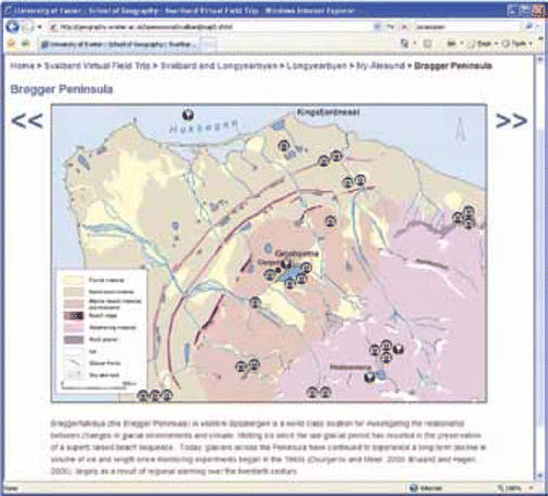
A virtual fieldtrip of Svalbard. This resource pulls together rich media resources collected by staff during trips to the west of the Islands. This module underpins our view of what OER should be about-access to resources that would otherwise sit gathering dust in a photo-album or on a hard-drive. This view is discussed in more detail below.
Figure 1 An example of one of the OER resources.
Constructing the resource
Our final product bears little resemblance to the original idea of an ‘all singing — all dancing’ guide. At the first project planning meeting the team drew up a wish list of resources that we felt had to be included to offer students the best OER package. At the core of the original plan was a set of articles, websites and book chapters that would provide students with the latest thinking on how the cryosphere works. These would be woven together through a series of lectures supported by online materials and rich media resources supplied by the participating staff members. On paper it looked fantastic. The reality of IPR and copyright soon killed it off as access to material from journals and books proved impossible to get without wasting huge amounts of staff time and money. This was always going to be a major thorn in the side of any OER project but the scale of the problem only became clear once we tried to get permission from the various publishing houses. A change of emphasis was required and a shift to our own staff resources quickly became the logical focus. Most geographers possess a personal archive of photographs, video and audio clips they have amassed over several years of fieldwork that is rarely used in teaching. Time is such a precious resource in University departments that even if academics have the relevant photograph for a lecture it is often quicker and simpler just to download something from the internet. It very soon became clear that any attempt to incorporate the images we currently use in teaching would be such a protracted and painful experience as to make participation in the project unsustainable. We therefore took the step of trying to produce material that only incorporated our own material where we could be certain of obtaining copyright clearance from the right holders. Once the decision was made to focus on staff material the process of fleshing out a new scheme was quick and the three units quickly evolved. It was decided that the resource would be pitched at level 2/3 undergraduates to maximize its use in teaching. However, our hope is that it will be a useful resource for all under-graduates and even entry level postgraduates. Through monthly meetings of the working group resources were produced and vetted for material that had copyright clearance issues. An internal peer review system was set up in the group to assess the quality of material and to root out any questionable resources that may have infringed copyright and IPR.
Aside from the legal support provided by the University, the biggest source of support for the Exeter OER project was the School Cartographic office who did an amazing job drawing up maps and re-drafting diagrams for inclusion in the project. Cartographic support in many Geography Departments has been a casualty of financial cutbacks, but Exeter is lucky to have held on to this valuable resource. Our conversations with the drawing office touched upon a key question in OER — that of derivative work. Can you re-draft a published diagram and avoid infringing copyright? We decided to err on the side of caution and in many cases diagrams/figures were dropped, to the detriment of resource quality. Nevertheless, the cartographers did a fantastic job, as you will see when you browse the resources.
The decision to base the material around a website was made very early on as it seemed the logical format to maximize access and maintain the connection between the resource and institution with Exeter. The material is also available on the Jorum Open repository but it is likely that the resources will also be hosted on the school website. Although the Jorum Open repository provides a one stop shop for all the UK OER programme resources, there is a question mark over how many of these materials will be accessed by the general public. In hosting a parallel site on the school website we hope we will improve access and have a greater number of entry points for users. Once completed, the material we produced was passed to the University legal department who confirmed that none of the material we intended to submit infringed copyright/IPR. The whole package was then assembled, cleared for publication and uploaded to the Jorum Open repository.
The one that got away
A key image we made special efforts to get copyright clearance for was a wonderful satellite image of the Brögger Peninsular that was hosted by the Nordic Polar Institute on their website. Our intention was to modify the image by annotating it with key geomorphic features. This annotated image would be embedded in our OER resource, whilst the pristine original remained in the control of the Norsk Polar Institute. In all other matters the Norsk Polar Institute have been incredibly helpful and generous over the years, but in this instance our efforts failed. This is not to be unexpected, especially when you consider the issues involved in trying to explain the complexity of a Creative Commons agreement over email or phone to someone when you do not share a common first language. Furthermore, we all agreed that if we were approached about an image on our website, the time taken up in trying to find the legal owner of the image to get clearance would not be worth our time and effort. Our experience in trying to gain permission for this single image nicely summed up to the group the problems of creating an OER.
Lessons learned
The project provided a great opportunity to produce what we hope is a high-quality educational resource that showcases the School and the University. This was only possible due in part to the School 's agreement that the cost of staff time would be waived, and the willingness of staff to take on this work in addition to their usual workload. Access to the School drawing office proved invaluable; indeed the project could not have got off the ground without their assistance. Copyright and IPR issues will continue to complicate any future OER work; even with the guidance provided through the GEES Subject Centre, this still remained a very frustrating area to deal with. Scaled up to the School and University level, the cost implications are enormous and it is hard to see the benefit of repurposing material at this scale. Maybe the future of OER is to start from scratch, updating modules over time as they are replaced. How appealing this would be to a first time lecturer, with limited time to develop their new courses is unclear.
The Cryosphere OER Resource (2010) is available through Jorum Open at www.jorum.ac.uk. Search for GEESOER.
To explore, reuse or repurpose this partners OER please visit: http://geography.exeter.ac.uk/opensource/