Figures & data
Figure 1 The QMAP 1:250 000 Geological Map of New Zealand. Units are coloured by age except for Neogene and Quaternary volcanic rock units. The key is the original colour-age scheme proposed by Miles Reay in the early stages and generally followed.
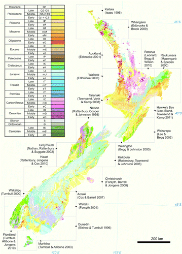
Figure 2 The QMAP GIS is a collection of digital layers, including features such as geological units, faults, landslides and structural measurements. Numbered examples of these are identified in the maps below. The layers are combined using GIS software to produce the printed map (left, from Haast QMAP, Rattenbury et al. Citation2010) or its equivalent viewed on-screen (right). Other standard layers in the QMAP GIS not shown here include metamorphic mineral zones, veins and data sources.
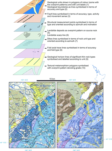
Figure 3 An area of southern Northland showing geological units of the Northland Allochthon with diagonal white striping, in contrast to autochthonous units in the east (Whangarei QMAP, Edbrooke & Brook Citation2009). Low-angle thrusts within the allochthon have juxtaposed older rocks upon younger and the displaced Cretaceous, Palaeogene and Miocene strata become increasingly dissociated to the south, passing into a sequence dominated by melange (shown here in grey).
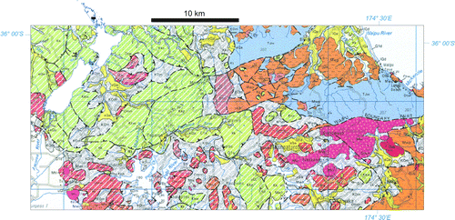
Figure 4 The mapped extent of thick deposits of the Mamaku Plateau Formation (magenta) that erupted from the Rotorua Volcanic Centre at c. 240 ka and that of the widespread c. 27 ka Oruanui Formation (blue) erupted from the Taupo Volcanic Centre, are highlighted from the Rotorua QMAP GIS data (after Leonard et al. Citation2010).
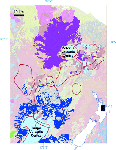
Figure 5 Quaternary alluvial, glacial and marine deposits in central Westland emphasised from the Greymouth QMAP GIS data. The unit labels beginning Q1, Q2, Q4 etc. refer to deposits of that oxygen isotope stage (OIS) age range. The last letter refers to the deposit type e.g. ‘a’ for alluvial; ‘t’ for till; and ‘b’ for beach. These Quaternary map units record the changing shoreline positions and ice limits between glacial and interglacial periods (interpretation modified after Nathan et al. Citation2002).
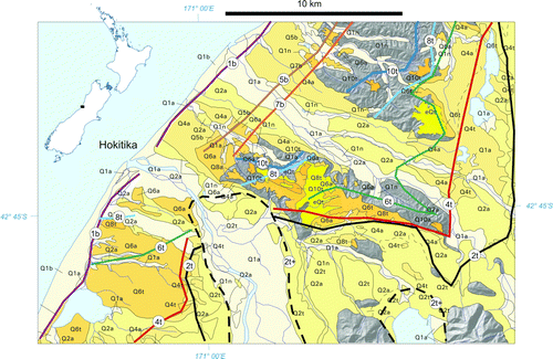
Figure 6 Percentage land area of dominant rock types based on the QMAP GIS digital database MAIN_ROCK attribute. Note that there is a bias, since QMAP does not map thin veneers of sediment and tuff.
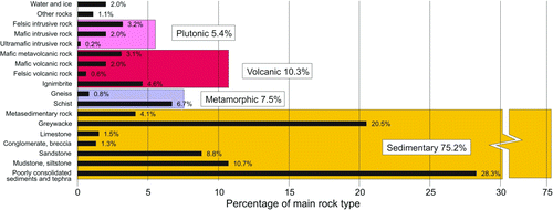
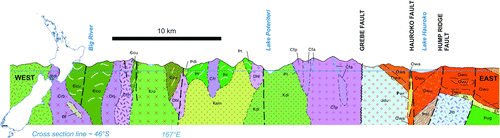
Figure 7 East–west cross-section through southern Fiordland (after Turnbull et al. Citation2010) highlighting the extent to which Median Batholith Cretaceous and Jurassic granitic plutons (mid-light greens and pale blues) have intruded Middle Paloeozoic plutons (pinks) and Early Palaeozoic metasedimentary and meta-igneous gneisses (dark-olive greens). Oligocene and Miocene sedimentary rocks (orange colour) overlie Palaeozoic and Mesozoic basement in the east (Waiau Basin).