Figures & data
Figure 1 Map of the central Southern Alps showing the location of the Acheron rock avalanche deposit.
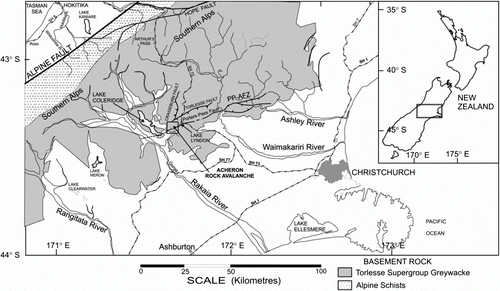
Figure 2 Geology and geomorphology of the Acheron rock avalanche deposit.
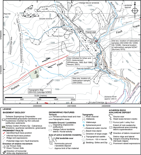
Figure 3 Geomorphic map of the Acheron rock avalanche deposit surface showing the lobate surface morphology and the site of the lichen and weathering-rind (W.R) measurements relative to the radiocarbon sample locations (this study). The location of the trench investigation is identified by the blue rectangle on the east side of the rock avalanche. The Porters Pass Fault trace is shown in red.
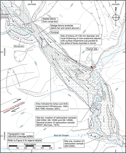
Figure 4 Three-dimensional view of the Acheron rock avalanche showing the position of the Porters Pass Fault (red line) and the Red Hill Fault (dashed black line).

Figure 5 The profile of the Acheron rock avalanche deposit and Late Quaternary/Late Triassic stratigraphy of the Red Hill valley.
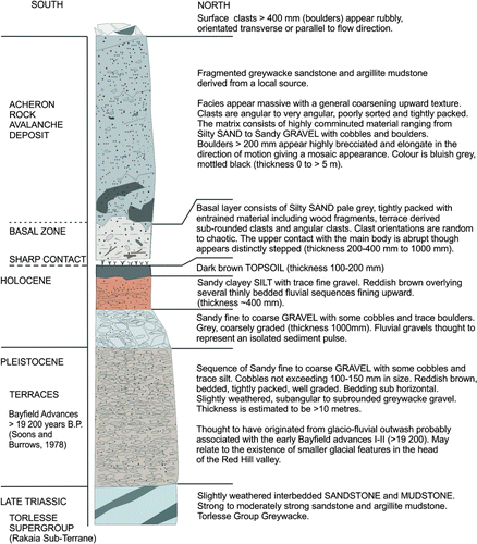
Figure 6 Timing of earthquakes on the Alpine Fault and Porters Pass Fault relative to geomorphic dating evidence of the Acheron rock avalanche and regional instability. The new radiocarbon ages for Acheron rock avalanche and the Porters Pass Fault trench investigation (this study) are presented as two-sigma calibrated calendar ages.
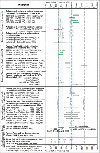
Figure 7 Location of sample Wk 12093 in southern stream bank (site one) near rock avalanche distal limit (Grid ref. K35/018 640).
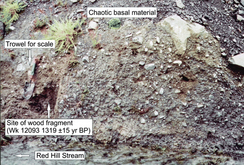
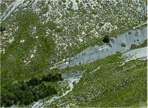
Figure 8 View of the exposed contact between the Acheron rock avalanche deposit and the underlying terrace surface (person arrowed for scale), described in Burrows (Citation1975). The location of the buried tree radiocarbon sample (Wk 12094; also referred to as site two), is along the continuation of the contact (see dashed line) below the bottom right of the photograph (second arrow indicates location).
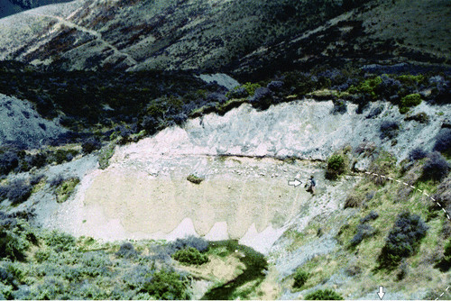
Figure 9 Section of trench through Porters Pass Fault immediately southeast of the rock avalanche deposit.
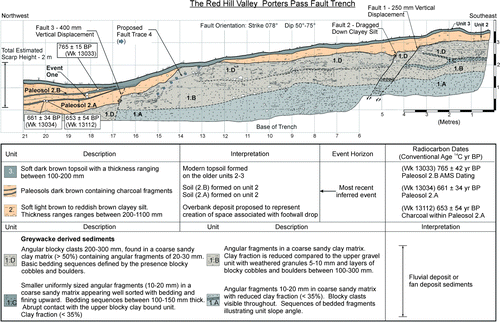
Table 1 Radiocarbon age results from the Acheron rock avalanche deposit and the Porters Pass Fault; includes radiocarbon results from this study and selected radiocarbon results from previous studies. Calibrated ages are reported to two-sigma.
Figure 10 Aerial photograph showing the mid zone of the Acheron rock avalanche crossed by the Porters Pass Fault. A zone of subdued surface expressions obliquely crossing the rock avalanche deposit is marked by the black arrows. Ridge rents and other fault-related lineaments are shown by red arrows. The white arrows show the trend of geomorphic features such as redundant water channels that correspond to the black arrows. The triangles indicate areas of coarse boulders, debris mass thickening and high elevation on the deposit that may reflect the presence of a buried fault scarp.
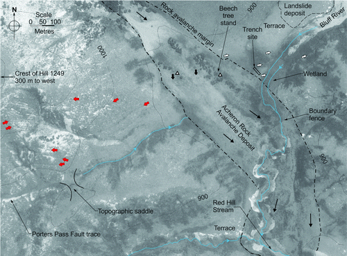
Figure 11 Photographs of the four samples sent to Waikato University Radiocarbon Laboratory for dating (scale bar is 3 cm). A, Wk12093 wood fragment from site one, 1319±51 yr BP. B, Wk12094 cut cross-section from buried tree at site two, 1152±51 yr BP. C, Wk12095 buried twig from site two 1232±52 yr BP. D, Wk12096 buried bark fragments retrieved from site two, 1327±52 yr BP.
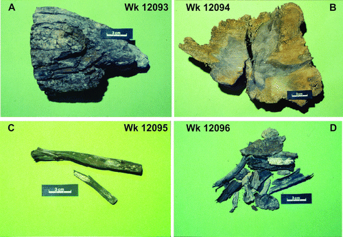
Figure 12 Photograph of sample site two containing the buried tree (Wk 12094), twigs (Wk 12095) and bark fragments (Wk 12096) within the contact between the rock avalanche and the terrace material (Grid ref K35/017 644). The buried tree is visible between the white arrow and 15 cm ruler.
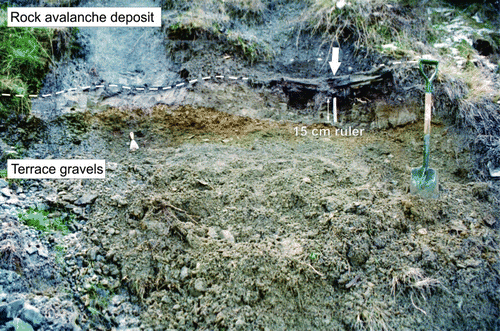
Table 2 Chi-square test results from combinations of radiocarbon age determinations for the Acheron rock avalanche deposit.
Figure 13 Double trim line between runups one and two. The distance between the single middle arrow and the stand of beech trees in the lower left of the photo is c. 100 m.