Figures & data
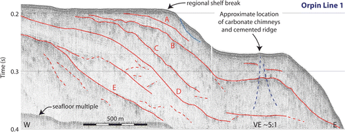
Figure 1 Position of sub-bottom profile surveys presented in this paper. Numbers refer to MSc theses of (1) Wilson (Citation1998), (2) Allan (Citation1990), (3) Gray (Citation1993), (4) Osterberg (Citation2001), (5) Orpin (Citation1992) and (6) Johnstone (Citation1990) for which the data were collected. Lines presented within this paper are identified by dotted lines and labelled with their line numbers; line numbers are unique only within a particular survey. Shaded topographical relief map on land. Offshore contoured colour bathymetry courtesy of NIWA. Contour interval 100 m. Inset map shows location of main map in relation to New Zealand and the regional plate boundary.
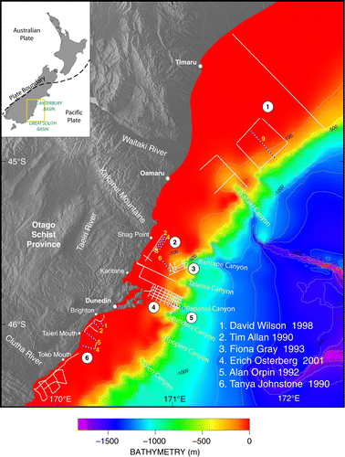
Figure 2 Schematic summary of the onboard Ferranti ORE Geopulse acquisition setup. Specifics of equipment include the towed boomer acoustic source unit (Model 5813A) and power supply (model 5420A), the hydrophone array (model 5110A), the receiver (model 5210A) and the model 4800 EPC graphic plotter.
Figure 3 Sections of two boomer lines highlighting Quaternary sedimentation from the shelf north of the Otago Peninsula. Wilson Line 9 (Wilson Citation1998) in water depths of 95–150 m off the coast of the Waitaki River) is interpreted to show sequence boundaries and idealised facies distributions (darker shading corresponding to finer grain sizes). Seven fifth- (c. 120 ka) or sixth-order (c. 41 ka) glacio-eustatic sedimentary sequences are annotated. Vertical exaggeration is about 11:1. Gray Line 6 (Gray Citation1993), crossing the landward edge of the Karitane Canyon on the shallow shelf, highlights the stratigraphy and erosional surfaces related to canyon development. The partially eroded present-day seafloor is underlain by the earlier somewhat-chaotic canyon fill sediments and a former erosional surface. Strata below the lower erosional surface are flat-lying and laterally coherent. Likely positions of sequence boundaries that have been cut off by (1) present and (2) ancient erosion are indicated. Vertical exaggeration is about 1.5:1.
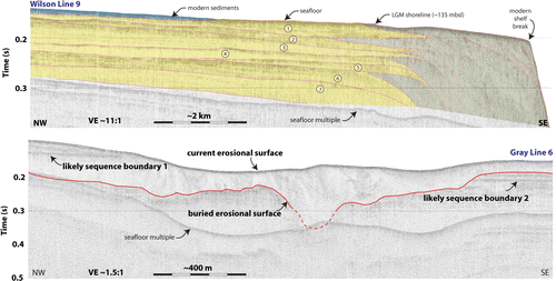
Figure 4 Boomer profiles 1, 2, 5 and 4 from the nearshore shelf south of Dunedin showing reflective units of the Cretateous–Tertiary sedimentary sequence (Johnstone Citation1990). In particular, coast-parallel faults and related deformation is imaged well in the upper 50 ms (roughly 50 m) of the seafloor. Faulting is indicated using black lines (solid and dashed, with solid having a higher degree of confidence). Labelled faults A, B and C are mapped in Fault displacement is indicated where apparent. Note possible seafloor displacement by faults on Line 1 (trace 3200) and Line 2 (trace 2800). Non-penetrative seafloor (regions indicated by white double-arrowed bars) is rare on this margin. Line positions as indicated in .
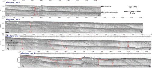
Figure 5 Offshore faults observed (solid lines) and inferred (dashed lines) along the South Otago margin (after Johnstone Citation1990). Seismic lines used in the fault interpretation are indicated by thin annotated lines; only lines 1, 2, 5 and 4 are shown in Onshore fault positions are indicated by white lines (after Bishop & Turnbull Citation1996). Onshore region is indicated by shaded topographical relief. Shelf margin bathymetry is indicated by grey contours.
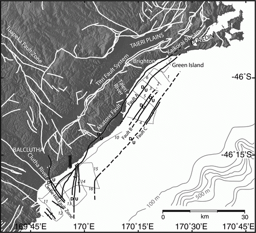
Figure 6 Coast-parallel boomer profiles 2, 3 and 4 located offshore from Shag Point (Allan Citation1990). The upper part of the water column has been removed from the plots. The profiles are aligned on the offshore Waihemo Fault (SW/left side of each plot). Quaternary sediments sourced from the Shag River to the south contrast strongly with the folded and faulted Cretaceous–Tertiary sequence NE of the fault. Numbered faults correspond to those interpreted in Vertical exaggeration is about 18:1.
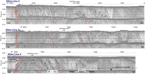
Figure 7 Schematic illustration of nearshore shelf geology in the vicinity of Shag Point seismic survey (survey 2 in ). Strands of the Waihemo Fault System are identified and labelled; dashed lines are inferred faults that link faults on land to interpreted faults on seismic data offshore. Weakly constrained interpretations of seafloor sedimentary unit outcrops are shown north of Waihemo No. 2 Fault. South of Waihemo No. 2 Fault, unmapped seafloor sedimentary units are assumed to be Pleistocene sequences overlain by modern Holocene sediments from the mouth of the Shag River. Seismic lines are indicated by light grey lines. Dips of contacts are annotated where they were determined from seismic sections.
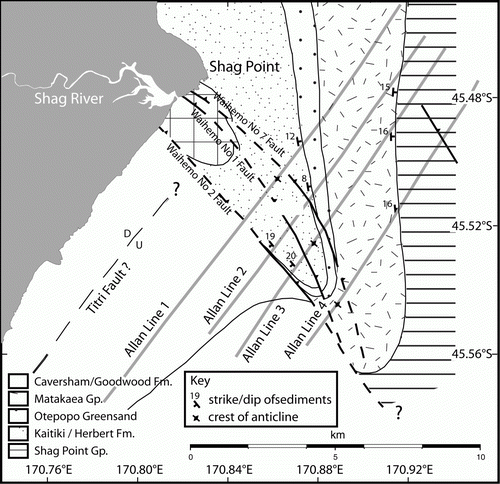
Figure 8 Shelf-perpendicular Line 1 (Orpin Citation1992) located between the Papanui and Saunders submarine canyons. The upper plot is uninterpreted. The lower plot shows an interpretation of earlier erosional surfaces (reflections A–E). The regional shelf break at a depth of approximately 140 m is interrupted by a <1 km2 bench at about 200 m. Here, fishermen dredging for scallops discovered a suite of carbonate concretions and chimneys (location indicated in lower plot) with some similarities to other methane vents observed elsewhere along the east coast of New Zealand. The surface expression of the ridge suggests a moderately east-dipping structure of north–south extent. This area can be seen as a small ‘bump’ on the seismic profile <2 m in height, below which Orpin (Citation1997) interpreted an eastwards-dipping slump-like feature, which is interpreted in the present study as a widening zone of disturbance below the chimney site (Line 1). Vertical exaggeration is about 5:1.