Figures & data
Figure 1 Geological location map of the Old Man Range and its protolith basement terranes (modified after Mortimer Citation1993; Turnbull Citation2000; MacKenzie & Craw Citation2005). Principal orogenic gold deposits, including the Hyde-Macraes Shear Zone (HMSZ), are also shown.
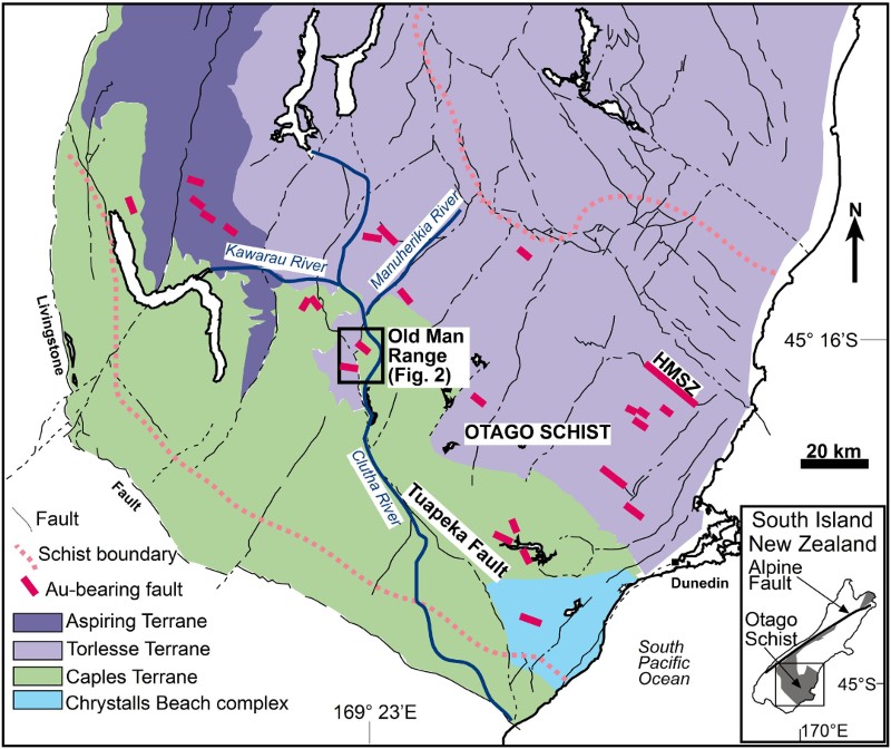
Figure 3 Structural contrasts between Torlesse and Caples Terrane schist basement. A, Aerial photograph (from Otago Regional Council) of a representative transect of Old Man Range topography (dashed box in ), showing stream control by joints in schist: west strike in Torlesse Terrane and northwest strike in Caples Terrane. B–E, Stereonets (lower hemisphere) showing orientations of foliations, lineations, joints and mineralised faults in Torlesse and Caples Terrane.
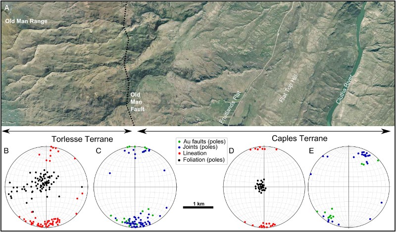
Figure 4 Field photographs of gold-bearing faults and associated structures. A, Outcrop of Alpine Reef. B, Jointed Torlesse Terrane schist near Alpine Reef. C, Silicified breccia with arsenopyrite in Alpine Reef. D, Fault breccia without silicification in mineralised fault in Caples Terrane schist c. 1 km southeast of Conroys Reef (A).
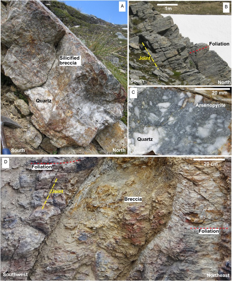
Figure 5 Scanning electron images of gold from mineralised faults. A, B, A gold particle has replaced folded metamorphic silicates in Torlesse Terrane schist, Grays Reef. C, Surface textures of a gold grain from silicified breccia, Alpine Reef. D, E, Supergene gold from Buds Reef intergrown with iron oxyhydroxide (HFO), with localised growth of gold crystal faces. F, Angular gold grain encapsulated in arsenopyrite (now oxidised to HFO) from Conroys Reef.
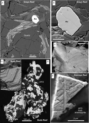
Figure 6 Mineralised breccia zones in north-striking structures associated with the Old Man Fault in Torlesse Terrane schists near to Buds Reef (after MacKenzie & Craw Citation2004). A–C, Cross-sections through road cuts, with measured distances from the western end of exposure. Deformed foliation and mineralised breccia zones are indicated. D, E, Stereonets (lower hemisphere) showing orientations of foliation and mineralised breccias in the cross section. F, Analytical data from mineralised breccias, showing sympathetic As and Sb enrichment. G, H, Scanning electron images of supergene gold particles from oxidised breccias. Fe ox = iron oxyhydroxide.
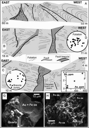
Figure 2 A, Hillshade topographic map of the Old Man Range showing the principal structures, mineralised faults and Clutha River channels described in this paper. Torlesse Terrane schists are indicated with a transparent pale overlay. B, Gold and As contents of samples from mineralised faults in the two basement terranes.
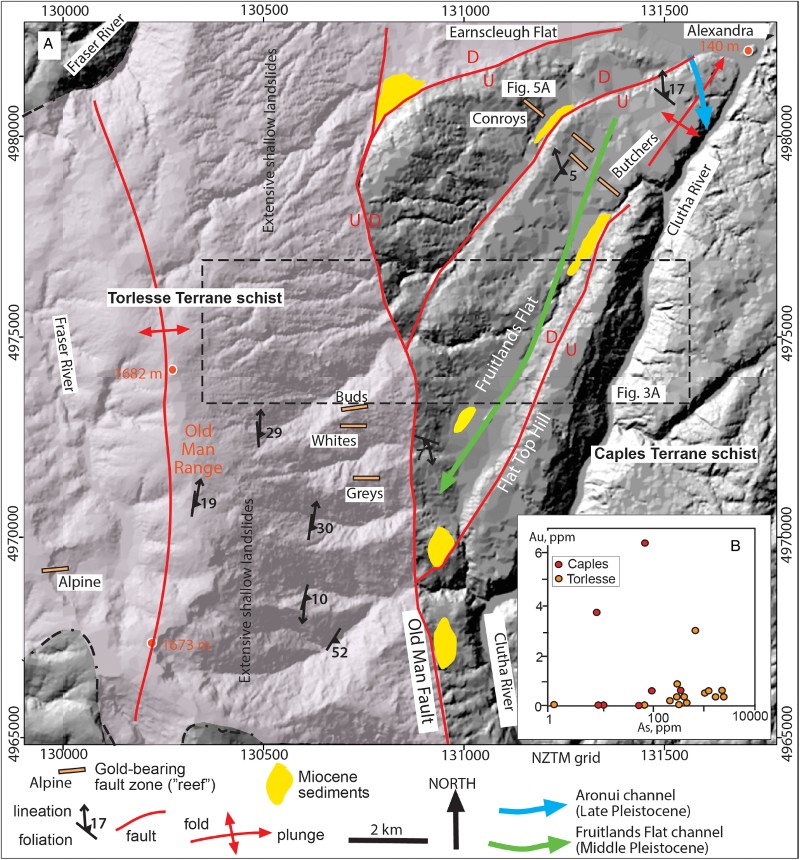
Figure 7 Structure of Conroys Reef area (). A, Map of the mineralised faults and host schist structure, superimposed on aerial photograph (from Otago Regional Council). B, Sketch cross-section through a mineralised fault in a mine adit, as indicated in A. C, Photograph of jointed host schist outcrop.
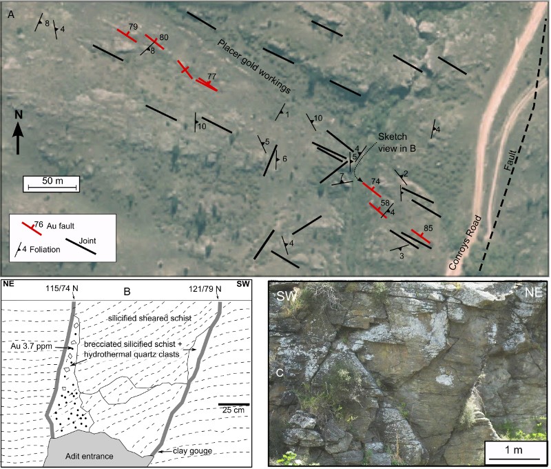
Figure 8 Photographs of quartz clasts and gold in late Cenozoic conglomerates (). A, Partially silicified silcrete boulder, showing abundant angular and subrounded clasts, in a sedimentary remnant near Conroys Reef (). B, Gold particles in a subangular cobble of prismatic quartz from the same site as in A. C, Sedimentary remnant near Butchers Reefs (), showing a prominent rounded quartz clast (lower centre right) amid numerous subangular quartz clasts. D, Gold particles extracted from the deposit in C showing generally angular and/or equant grains, apart from one flake (lower right).
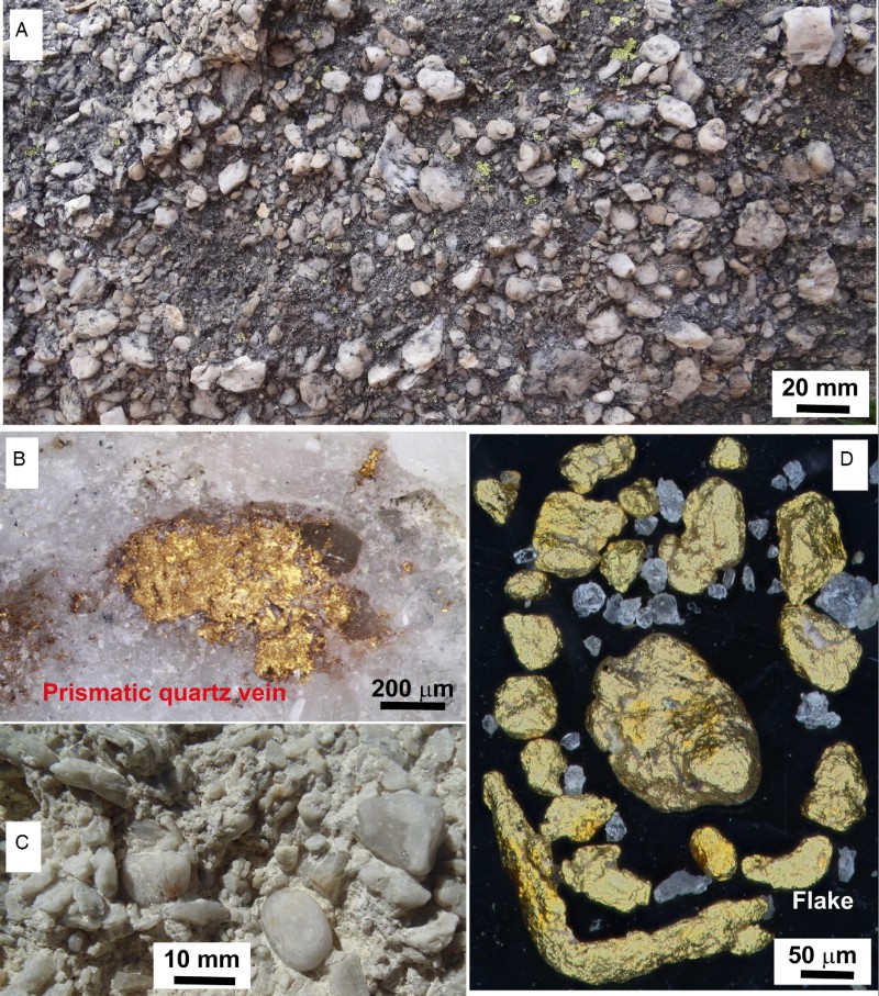
Figure 9 Pleistocene alluvial fan sediments exposed in historic mines on Fruitlands Flat. Gold occurs near to the basal unconformity, indicated with a dashed line in A and B. A, Pleistocene gravels are channelised in inferred Miocene quartz sandstone. B, Close view of the unconformity in A, showing angular and poorly sorted locally derived Pleistocene gravel. C, Pleistocene gravels that unconformably lie on Caples Terrane schist basement, with a mine adit that followed the unconformity.
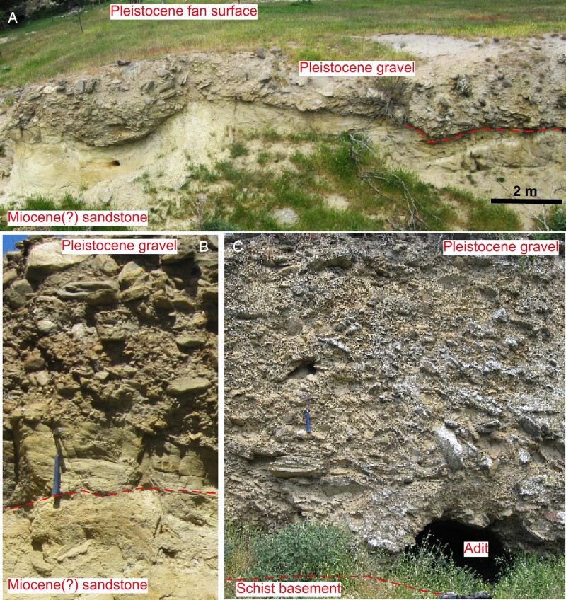
Figure 10 Scanning electron images of locally derived detrital gold particles from Pleistocene–Holocene sediments on the Old Man Range. A, Particle from gravels in Fraser River on the western side of the crest of the range (). B, C, Particles from basal unconformity of Pleistocene gravels at Fruitlands Flat (Fig. 10). D, Surface texture of the gold particle in C, showing minor post-depositional addition of gold as spherical buds (centre and lower right) and thin plates (right).
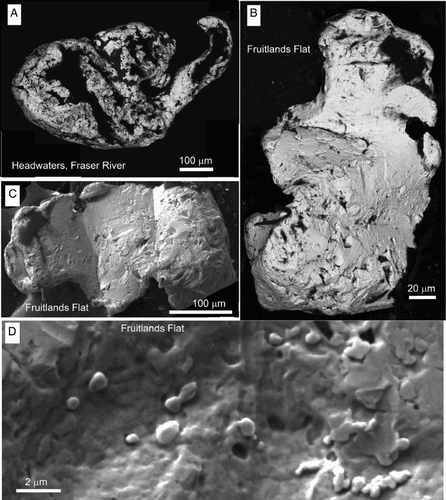
Figure 11 A schematic section of exposure of a wall of the Aronui channel of the Clutha River (Late Pleistocene; ). B–D, Lower channel sediments were transported by the Clutha River and include rounded clasts of highly variable provenance with flaky detrital gold. E, Upper sediments are locally derived angular and poorly sorted colluvium that post-dated channel abandonment, with minor rounded clasts of Torlesse Terrane greywacke recycled from the underlying Clutha sediments.
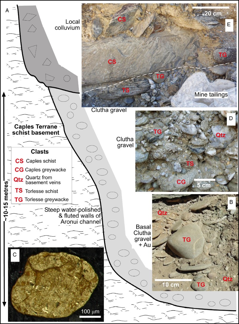
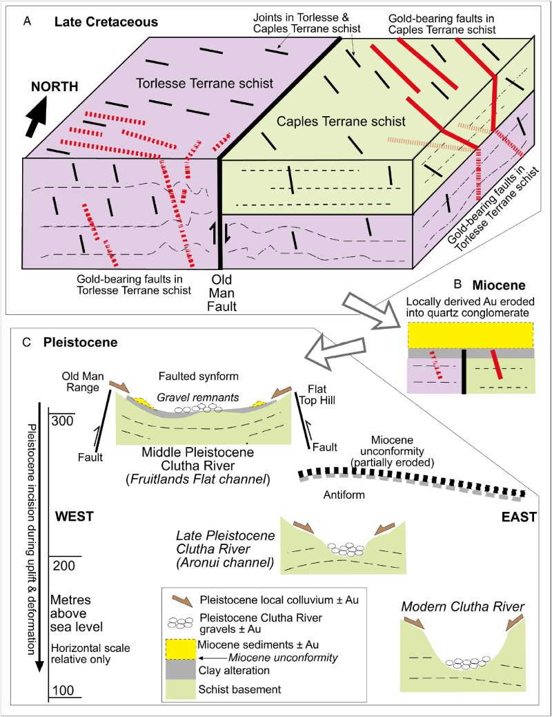
Figure 12 Conceptual sketches showing key stages in the evolution of the gold deposits of the Old Man Range. A, Block diagram contrasting the structure of orogenic gold deposits in Late Cretaceous faults cutting Torlesse and Caples Terrane schist basement. B, Miocene non-marine sediments collect some placer gold from underlying schist basement. C, Progressive downcutting of the Clutha River in the Pleistocene has facilitated gold placer formation, mainly from locally derived mineralised faults.