Figures & data
Figure 1. Location map for the Springvale Scientific Reserve in the Central Otago rain shadow zone. A, Contoured rainfall map of the South Island of New Zealand (modified from NIWA Citation2015), showing the Central Otago rain shadow in the lee of the Southern Alps mountains. B, Hillshade image showing folded mountain and valley topography in the Central Otago rain shadow and locations of principal saline sites. C, Oblique digital image (2× vertical exaggeration) of the Pleistocene Waikerikeri Fan emanating from the rising Dunstan Range, with Springvale site on the distal edge of the fan.
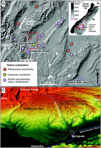
Figure 2. Stratigraphic sections through the Springvale site showing A, the inferred pre-mining landscape and B, the present landscape along the same section line. Vertical scale is exaggerated.
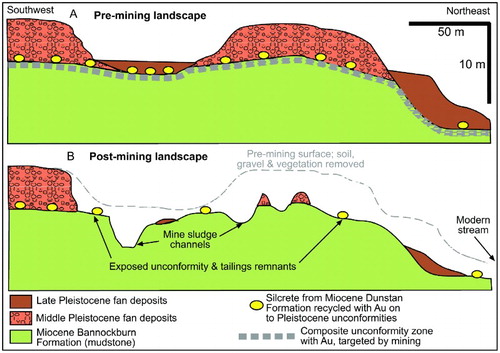
Table 1. Principal features of the rock units at Springvale Scientific Reserve. Age estimates are generalised from Turnbull (Citation2000).
Figure 3. Characteristics of Bannockburn Formation at Springvale. A, Outcrop photograph in a road cut, showing subtle bedding (red dashed lines) and desiccation cracking especially in the top bed. B, Close-up view of desiccation cracking, with scattered white evaporite mineral encrustations (red arrows). C, Backscattered electron image of exposed surface of mudstone outcrop, with salt encrustations (mostly halite) after a spring rain event.
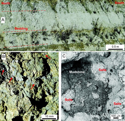
Figure 4. Pleistocene fan deposits at Springvale mine site. Clast types: S, schist; MC, metachert schist; G, greywacke; Sil, silcrete. A, Late Pleistocene gravel remnant, with loess horizon. B, Middle Pleistocene gravel remnant resting on the Bannockburn Formation (BF) unconformity. C, Close view of Middle Pleistocene gravel. D, Bannockburn Formation unconformity exposed where gravel has been stripped during mining, leaving large remnant boulders of silcrete and schist among finer gravel tailings.
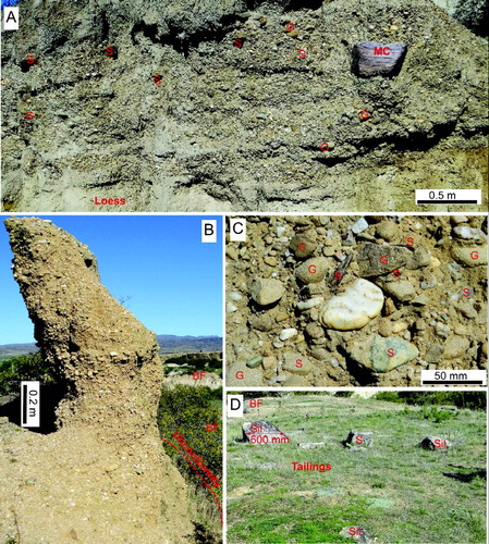
Figure 5. Maps of the Springvale mine site and scientific reserve: A, geological map; B, vegetation map; and C, conductivity measurement sites.
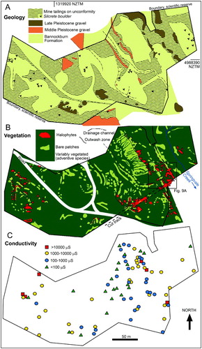
Figure 6. Setting for halophyte habitats on post-mining outwash pans below an actively eroding Bannockburn Formation mudstone outcrop exposed by mining. A, View of mudstone outcrop (top), with proximal outwash pans in the foreground. B, Close-up view of disaggregating Bannockburn Formation outcrop with mud cracks and temporarily well-developed salt encrustations formed after a spring rain event. C, Oblique view of proximal outwash pans with active water channels (pale) below salty Bannockburn Formation outcrops. D, Halophyte community (Atriplex buchananii; Puccinellia raroflorens) on outwash pan.
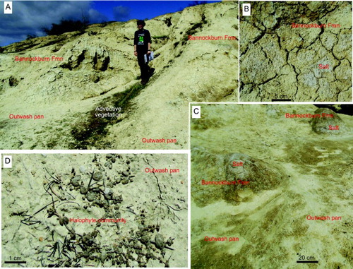
Figure 7. Scanning electron images (backscatter) of salt-encrusted Bannockburn Formation in the wall of an erosional rill (A). A, Salt encrustations overlie variably clay-cemented mudstone. B, Close-up view of variably dissolved and recrystallised halite crystals, with a possible bloedite crystal at top. C, D, Interior of mudstone (2 mm below surface) showing variable clay cementation of detrital silicates.
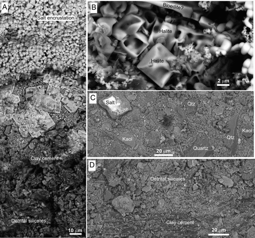
Figure 8. Scanning electron microscopic view of the surface textures and mineralogy of the exposed surface of outwash pan sediment. A, B, Disaggregated detrital silicates locally have a veneer of salt encrustations. C, Backscatter electron image, showing the loose granular texture with equant quartz and albite grains and kaolinite flakes. D, E, Energy-dispersive X-ray maps of area in C (reduced scale) with distributions of chlorine and calcium depicting distribution of evaporitic salts. D, Chlorides are present as micron-scale veneers. E, Composite crystals of calcite. F, G, X-ray maps of silicon and aluminium, showing distributions of silicates, especially quartz, albite and kaolinite.
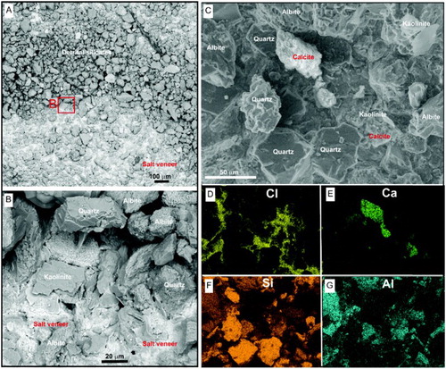
Figure 9. Halophytes on outwash pans and other post-mining disturbed ground at Springvale site. A, Enlarged view of a portion of site map in , showing the relationships between Bannockburn Formation outcrops and pans with halophytes. B, View of halophyte clusters on a flat outwash pan. C, Conductivity transect from adventive vegetation at the margin of pan in B across the saline pan.
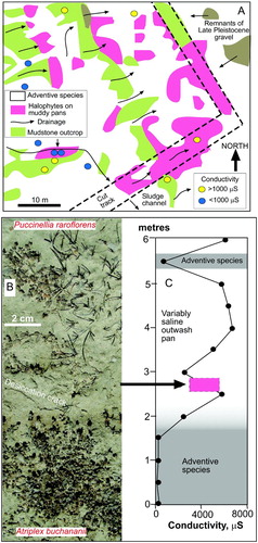
Figure 10. Conductivity and pH plots for data collected across the Springvale site. A, Comparison of substrate chemistry for halophytes (purple symbols and background) and adventive vegetation. B, Comparison of substrate chemistry for bare Bannockburn Formation mudstone outcrops (green symbols and background) with bare gravel.
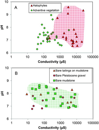
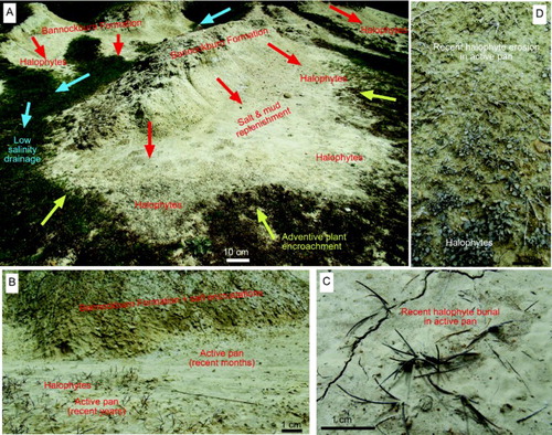
Figure 11. Summary of dynamic processes that affect halophyte habitat at the Springvale site. A, Remnants of Bannockburn Formation (small ridges) were exposed below the gold-bearing unconformity and were incised by mine channels. Rain runoff (red arrows) has eroded the outcrops to form small saline outwash pans on which halophytes have become established. The floor of a mine channel (left) and distal parts of the pans have low salinity and now host adventive species, which can encroach laterally wherever and whenever the adjacent substrate salinity decreases below c. 1000 µS. B, Close view of a boundary between saline but unvegetated Bannockburn Formation outcrop (top) and a variably active saline outwash pan with halophytes (bottom). C, Active pan formation (recent months) has partially buried halophytic Puccinellia. D, Active pan erosion (recent months) has partially eroded halophytic Atriplex (top) while some of the halophytes survive (bottom).