Figures & data
Figure 1. Location map showing the geological mapping boundaries of Carter (Citation1972) in the Komako District and Rees (Citation2015) in the Lower Pohangina Valley. Major regional faults and folds are displayed for reference. PFM = Pohangina Faulted Monocline after Marden (Citation1984). Main roads and urban areas are displayed. Geological data sourced from Rich (Citation1959), Carter (Citation1972), Marden (Citation1984), Beanland (Citation1995) and Rees (Citation2015). Topographic data sourced from LINZ Data Service, Crown Copyright Reserved.
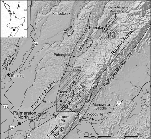
Figure 2. Composite stratigraphic column of the Lower Pohangina Valley succession.
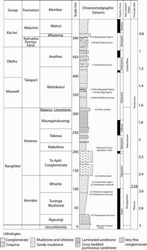
Figure 3. Photographs of parts of the constituent members of the Konewa Formation and Kai Iwi group. A, High energy cross beds and rip up clasts of Potaka Pumice (0.99 Ma), Kaimatira Pumice Sand Formation, Kai Iwi group, unnamed tributary of the Pohangina River, Broadlands Station, Lower Pohangina Valley (WGS84 40°15′21.56′′S, 175°46′59.95′′E, elevation 134 m). B, Ratanui Limestone Member upper contact for Konewa Formation in the Lower Pohangina Valley, spade is approximately 1 m, Unnamed tributary of the Pohangina River informally referred to here as Scrimmys Stream, Broadlands Station, Lower Pohangina Valley (WGS84 40°16′44.78′′S, 175°46′44.78′′E, elevation 112 m). C, Close-up of B, Ratanui Limestone Member displaying common Talochamlys gemmulata, Ostrea chilensis, Calloria inconspicua, Purpurocardia purpurata and Talabrica senecta. Last appearance of Patro undatus in the Lower Pohangina Valley. D, High energy, erosional base of Whareroa Conglomerate Member, Kai Iwi group, note lenses of tephric rich silts (Kaukatea Tephra, 0.9 Ma) eroded from underlying beds incorporated into wavy beds of the pebbly conglomerate. Also, steep dip of the beds 40°@315, 200 m west of the apex of the Pohangina Faulted Monocline characterised by near vertical bedding, Whareroa Stream, Lower Pohangina Valley (WGS84 40°16′48.79′′S, 175°46′51.12′′E, elevation 115 m).
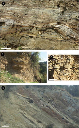
Table 1. Stratigraphic nomenclature used in the Whanganui and East Coast Basins ordered from west to east. The stratigraphic nomenclature used in this paper is displayed in the centre column. Note there is a 450 ka unconformity at the base of the Butlers Shell Conglomerate in the coastal Whanganui section. This unconformity is not present to the same extent in the eastern Whanganui Basin where extensive early Pleistocene, volcaniclastic sediments are preserved.
Figure 4. Photographs of observed fault planes and dip slopes in the Lower Pohangina Valley. A, Whareroa Conglomerate Member, Kai Iwi group forming a dip slope 35°@280 on Broadlands Station, Lower Pohangina Valley (WGS84 40°15′37.78′′S, 175°47′07.41′′E, elevation 127 m). B, Exposure of a normal fault in an unnamed tributary of the Pohangina River, informally referred to here as Scrimmy’s Stream (). This fault is interpreted to be antithetic to the Raukawa Fault located at depth, Broadlands Station, Lower Pohangina Valley (WGS84 40°16′50.47′′S, 175°46′46.25′′E, elevation 98 m). C, Antithetic fault plane dipping 75° west, associated with the Raukawa Fault, south branch of Whareroa Stream, Broadlands Station, Lower Pohangina Valley, Manawatu (WGS84 40°14′53.57′′S 175°48′40.18′′E, elevation 221 m). Note the amount of offset in this area is such that Takapari Formation is offset beside Komako Formation. D, Te Apiti Conglomerate Member of Konewa Formation forms the ridge coming to the foreground. The high angle dip slope (52°@275°) is formed by movement on the Whareroa Fault located in the far right of this image, Maungatukurangi Stream, Broadlands Station, Lower Pohangina Valley.
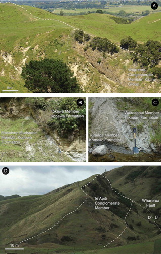
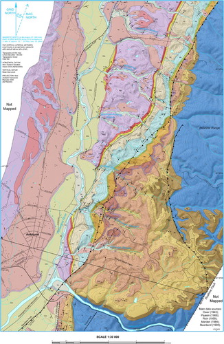
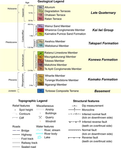
Figure 6. Geological cross section A–A′ trending west–east across the Lower Pohangina Valley. Geological data sourced from Rich (Citation1959), Marden (Citation1984) and Rees (Citation2015). Topographic data sourced from LINZ Data Service, Crown Copyright Reserved.
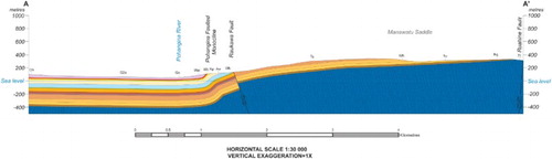
Figure 7. Preliminary 3D geological model of the Lower Pohangina Valley looking northeast. Deeply incised and eroded Plio-Pleistocene coverbeds unconformably overly Torlesse Group, exposed by uplift and erosion adjacent to the axial range. Note this is a schematic representation of the geology displayed on the 1:30,000 geological map and interpreted subsurface geology from cross section analysis. Geological data sourced from Ower (Citation1943), Rich (Citation1959), Piyasin (Citation1966), Marden (Citation1984), Beanland (Citation1995), Beu (Citation1995) and Rees (Citation2015). Topographic data sourced from LINZ Data Service, Crown Copyright Reserved. Model constructed using LeapfrogTM software developed by ARANZ Geo.
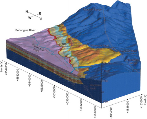
Figure 8. Schematic depiction of the paleogeography for the lower North Island during a sea level highstand in Mangapanian time (2.7 Ma) showing location of Kuripapango, Manawatu and Ruataniwha straits. Data derived from Beu (Citation1995), McIntyre (Citation2002), Bland (Citation2006), Nicol (Citation2011), Trewick and Bland (Citation2012) and Rees (Citation2015). Contains information licensed under the NIWA Open Data License v1.0. Faults derived from the GNS faults database.
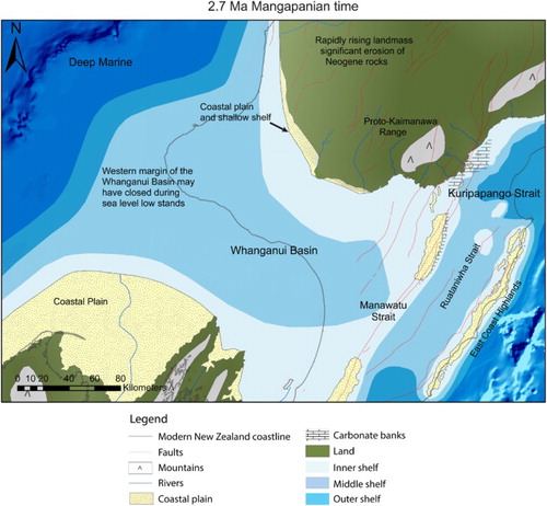
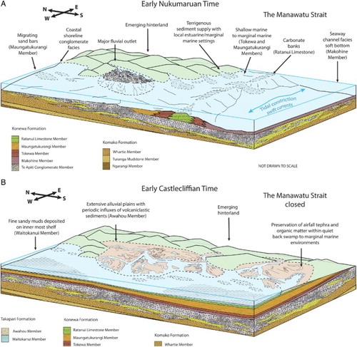
Figure 9. Schematic summary of the inferred environments of deposition in the Lower Pohangina Valley. A, Interpreted environments of deposition within the Manawatu Strait during early Nukumaruan time (2.4 Ma). B, Interpreted environments of deposition in the study area following closure of the Manawatu Strait in early Castlecliffian time (1.63 Ma).