Figures & data
Figure 1. A, Tectonic setting and upper crustal geology of the South Island. The arrow shows the motion of the Australian Plate relative to the Pacific Plate (DeMets et al. Citation2010). Geological terranes are from Mortimer (Citation2004). The southern, central and northern sections of the Alpine Fault are shown in green, orange and red respectively (Howarth et al. Citation2014). The fault is shown with barbs in its central section where fault motion is oblique. AO, Aorangi/Mt Cook; HO, Hokitika; MFS, Marlborough fault system; MS, Milford Sound. B, Lower crustal structure of the southern South Island, based on seismic tomography and relocated earthquakes (Reyners Citation2005; Reyners et al. Citation2011, Citation2017a, Citation2017b). Dashed lines show isobaths (in km) to the top surfaces of the Emerald Basin oceanic crust and the Hikurangi Plateau and its adjacent Cretaceous oceanic crust. Dark purple shows the thickest part of the Hikurangi Plateau, where Vp > 8.5 km/s at the base of the plateau. The edge of the plateau then thins towards the Cretaceous oceanic crust on which the plateau was originally emplaced (light purple). The stippled area is the crustal root of the Southern Alps, here defined by Vp < 6.5 km/s at 30 km depth. Labels A, B and C denote crustal thickness (in km) from SIGHT transects 1 and 2 (Scherwath et al. Citation2003; van Avendonk et al. Citation2004) and a Pn study (Bourguignon et al. Citation2007) respectively. The locations of the depth sections in are also shown.
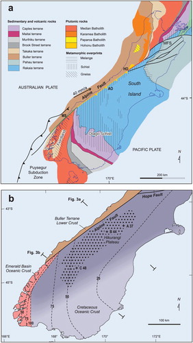
Figure 2. Snapshots of the tectonic setting A, just before and B, just after Alpine Fault formation as a STEP fault (after Reyners Citation2013, incorporating new information on the shape of the Hikurangi Plateau from Reyners et al. Citation2017a). TKSZ denotes the Tonga–Kermadec subduction zone. This drove STEP fault formation, rolling back by ripping oceanic crust seaward of the trench from the western edge of the plateau. The background Southwest Pacific plate reconstruction is that of Schellart et al. (Citation2006), with an Australia-fixed reference frame. The Hikurangi Plateau (HP) is shown in purple, with its currently subducted part light, and the portion yet to be subducted dark. The fossil trench where the plateau partly subducted under Gondwana at c. 105–100 Ma is marked by the grey barbed line. The Alpine Fault is shown in red, and the strike-slip fault that formed at the Emerald Basin (EB) spreading centre upon Alpine STEP fault formation is shown in blue.
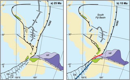
Figure 3. Depth sections of structure and tectonics in A, central and B, southern parts of the Alpine Fault. The location of the sections is shown in (B). Smoothed topography on each section is from Davey et al. (Citation2007). In A, the dashed line represents the original location of the Alpine STEP fault, which is now inactive. Because of rapid exhumation due to restricted accommodation space above the shallow Hikurangi Plateau (HP), plate motion in the upper crust is accommodated by oblique motion on a listric Alpine Fault. But in the mafic lower crust (EBOC and HP), plate motion is partitioned. In B, exhumation is much less, because of much more space above the HP to accommodate crustal shortening. Here, plate motion in the upper crust is partitioned, with the strike-slip component of plate motion taken up by the Alpine STEP fault. AF, Alpine Fault; AO, Aorangi/Mt Cook; BTLC, Buller Terrane lower crust; COC, Cretaceous oceanic crust; EBOC, Emerald Basin oceanic crust; OBR, Otago basin and range province.
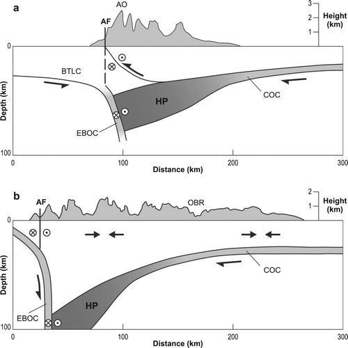
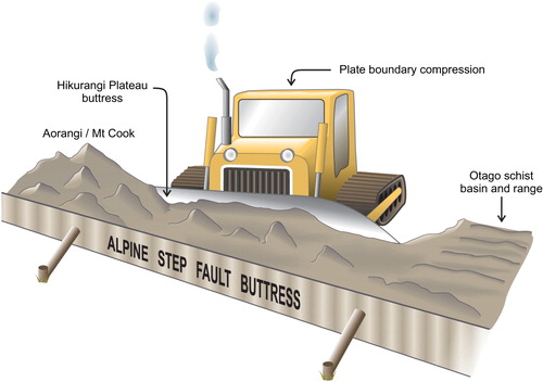
Figure 4. Cartoon illustrating how crustal deformation in the central South Island is buttressed by both the incoming Hikurangi Plateau (the bulldozer blade) and the Alpine STEP fault (the wall). The angle between these buttresses is 16°. This results in less accommodation space and more exhumation in the Aorangi/Mt Cook region, and more accommodation space and thus less exhumation towards the south. Further south the Hikurangi Plateau deepens as a result its subduction at the Gondwana margin, and the buttressing effect of the plateau is lost. This enables the widening of the zone of active deformation into the Otago schist basin and range.