
Figures & data
Figure 1. Maps showing plate boundary setting of Kaikōura Earthquake. (A) New Zealand plate boundary. AF: Alpine Fault; Hikurangi subduction interface. (B) November 14 2016 Mw 7.8 Kaikōura Earthquake fault ruptures observed at the surface or modelled using surface deformation (red lines with key fault names shown; THF, The Humaps Fault; HF, Hundalee Fault; OSTF, Offshore Thrust Fault; UKF, Upper Kowhai Fault; JF, Jordan Fault; PF, Papatea Fault; KF, Kekerengu Fault; NF, Needles Fault)(modified from Litchfield et al. Citation2018; Howell et al. Citation2020). Active faults shown by black lines are from Langridge et al. (Citation2016). The epicentral location of the Kaikōura Earthquake (yellow star, Chamberlain et al. Citation2022) is shown. Location and authors of studies in this special issue are shown. Onshore topographic basemap is from LINZ and bathymetry is from NIWA. MFS: Marlborough Fault System; NCD: North Canterbury Domain.
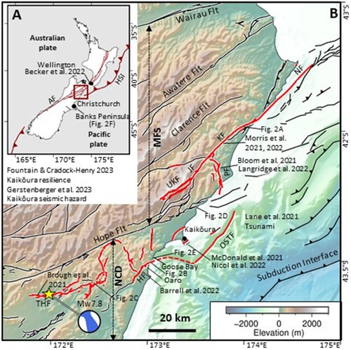
Figure 2. Photographs showing surface rupture, damage to transport infrastructure and buidlings, landslides and coastal uplift from the 2016 Kaikōura Earthquake. (A) Surface rupture of the Kekerengu Fault where it displaces a farm track by ∼6.8 m horizontally (right lateral)(Site 23 in Kearse et al. Citation2018). Photograph looking northwest and taken by Tim Little on 20 November, 2016. (B) Rupture of State Highway 1 along the Hundalee Fault immediately north of Oaro, where ∼3.7 m right-lateral and ∼1.5 m vertical displacement accrued in the earthquake (Williams et al. Citation2018). Photograph looking northeast and taken on 14 November 2016 by Daniel Bullen. (C) Leader landslide viewed towards the northeast. The landslide volume is ∼6 million m3 and dammed the Leader River to produce the ∼1100 m long Lake Rebekah (Abad et al. Citation2022). Photograph by Kate Pedley, 11 December, 2016. (D) Displaced railway tracks Half Moon Bay. The railway tracks were dislodged and transported seawards >100 m by a landslide (top left of the photograph) which blocked State Highway 1 and came to rest on the shore platform. Photograph by Vasiliki Mouslopoulou, 5 February, 2017. (E) Coastal uplift of ∼2 m south of Kaikōura showing high-and-dry marine fauna and flora (e.g. paua, bull kelp and coralline algae) the day of the earthquake. Photograph by Will Wilding, 14 November, 2016. (F) Kaikōura Earthquake tsunami caused extensive damage to a historical cottage at Little Pigeon Bay on Banks Peninsula. Locally the tsunami reached a height of ∼3 m at this location, with the anomalously large wave height being due to the narrow bay and its north facing aspect. Photograph by William Power, November, 2016. For locations of A-E see .
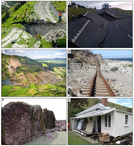
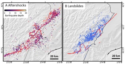
Figure 3. Maps showing aftershocks (A) and landslides (B) associated with the earthquake. Earthquakes are from Chamberlain et al. (Citation2022) and landslides from Massey et al. (Citation2018).
Data availability statement
The data that support the findings of this study are provided in this paper or the papers that the article refers to.