Figures & data
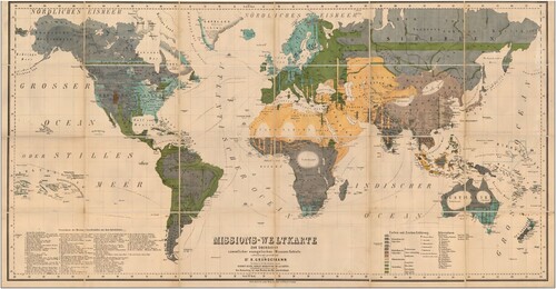
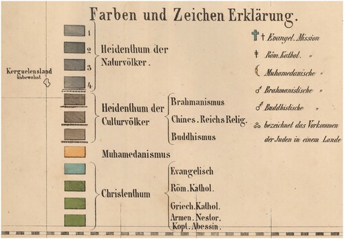
Table 1: Colours on Protestant World Maps
Gilbert, John, Pictorial Missionary Map of the World (London: James Nisbet & Co., 1861) (13a). Wyld, James, An Atlas of Maps of Different Parts of the World; Designed to Show the Stations of the Protestant Missionaries (London: J. Wyld, 1839) (1). Koenig, Theophil, Weltkarte mit Angabe der protestantischen Missions-Anstalten und der WichtigstenSchiffuhatscourse (Berlin: Verlag der Nicolai'schen Buchhandlung, between 1840 and 1861) (2). Society for the Propagation of the Gospel in Foreign Parts, A Colonial and Missionary Church Map of the World (London: Society for the Propagation of the Gospel, 1842) (3). Tracy, Joseph, The World, on the globular projection with a graduation for the measurement of distances especially adapted for the use oe [sic] schools, geographical & historical lectures, and missionary meetings (Boston: Crocker and Brewster, 1843) (4). Nisbet, James, ‘Children’s Missionary Map … Extracted from Children's Missionary Magazine‘ (London: January 1843) (5a) R., W., Missions-weltkarte für jung und alt (Elberfeld: P.W. Kreeft, 1845) (5b). Bäschlin, H., lith. Welt-Karte der Mission (Schaffhausen: Evangelischen Missions-Anstalt Basel, 1844) (6a). Gover, Edward, The Protestant Missionary map of the world (London: Seeley, Burnside & Seeley, 1846) (7) Morse, Sidney E., The Cerographic Missionary Atlas (New York: Sidney E. Morse & Co. 1848) (8). Groen, J.A., A.J. Zn., del.; A.J. Wendel, engrav., ‘Wereldkaart der christelijke zendingsposten’ (s.l.: Meerburg impressum, 1851) in Handboek voor de vrienden der zendingszaak ten gebruike bij het houden en bijwonen der maandelijksche bedestonden voor de uitbreiding des christendoms (Leyden: C.C. van der Hoek, 1851) (9a). Josenhans, Joseph, Atlas der evangelischen Missions-Gesellschaft zu Basel: Nach den Angaben der Missionare Locher (Basel: Basler Mission, 1857) (11). Trap, Pieter Willem Marinus, Zendingsprentenkaart (Rotterdam: M. Wijt, 1863?) (13b). Grundemann, Reinhold, Missions-Weltkarte zur übersicht sämmtlicher evangelischen Missions Gebiete (Leipzig: Kunsch, 1862) (14a). Grundemann, Reinhold, Zending-wereldkaart tot een overzigt van geheel het evangelische zendingsgebied (Kemink: Utrecht 1867) (14b). Grundemann, Reinhold, Neuer Missions-Atlas aller evangelischen Missionsgebiete mit besonderer Berücksichtigung der Deutschen Missionen (Calw: Verlag der Vereinsbuchhandlung, 1896) (16c). Grundemann, Reinhold, Allgemeiner Missions-Atlas nach Originalquellen: mit erläuterndem Texte (4 vols, Gotha: Justus Perthes, 1867-1871) (16b) Grundemann, Reinhold, Kleiner Missions-Atlas zur Darstellung des evangelischen Missionswerkes (Stuttgart: Verlag der Vereinsbuchhandlung, 1886) (16a). Grundemann, Reinhold, Neuer Missions-Atlas aller evangelischen Missionsgebiete mit besonderer Berücksichtigung der Deutschen Missionen (Calw: 1903, Verlag der Vereinsbuchhandlung, 2nd ed.) (16d). Colton, George Radcliffe, Missionary Map of the World Showing the Prevailing Religions of its Various Nations and the Central Stations of All Protestant Missionary Societies (New York: G.W. and C.B. Colton, 1906) (17). Missionsdirektion der Evangelischen Brüder, Missions-Atlas der Brüdergemeine, Achtzehn Karten mit erläuterndem text (Herrnhut: Missionsbuchhandlung, 1907) (18a). Moravian Church and Mission Agency, The Moravian Missionary Atlas: Containing an Account of the Various Countries in which the Missions of the Moravian Church Are Carried On, and of its Missionary Operations (London: Moravian Church and Mission agency, 1908) (18b). World Missionary Conference Committee 1, Statistical Atlas of Christian Missions: Containing a Directory of Missionary Societies, a Classified Summary of Statistics, an Index of Mission Stations, and a Series of Specially Prepared Maps of Mission Fields (Edinburgh: The conference, 1910) (19a) Beach, Harlan, et al., World Atlas of Christian Missions: Containing a Directory of Missionary Societies, a Classified Summary of Statistics, an Index of Mission Stations, and Maps Showing the Location of Mission Stations throughout the World (New York: Student Volunteer Movement for Foreign Missions, 1911) (19b). Beach, Harlan and Charles H. Fahs, World Missionary Atlas, Containing a Directory of Missionary Societies, Classified Summary of Statistics, Maps Showing the Location of Mission Stations Throughout the World, a Descriptive Account of the Principal Mission Lands, and Comprehensive Indices (New York: Institute of social and religious research, 1925) (19c). Koetsveld, Cornelis Elisa van, Godsdienst- en zendingskaart voor den nieuwsten tijd (Groningen: Oomkens Jz, 1855) (10).