Ivan RyzhovArctic and Antarctic Research Institute, Russian Federal Service for Hydrometeorology and Environmental Monitoring, St. Petersburg, RussiaView further author information
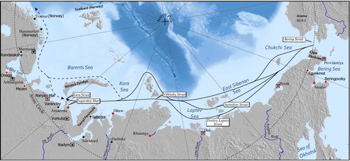
Figure 2. Map of the Russian and Norwegian Arctic coasts, showing the NSR (solid line) and its extension to the NEP (dotted line). Settlements in red have been identified by the Russian Government (FSUE Citation2013) as having port facilities in a state of disrepair. Planned SAR stations are also identified with a square (adapted from Stephenson et al.Citation2013a).
Stephenson, S.R., Smith, L.C., Brigham, L.W., and Agnew, J.A., 2013b, Projected 21st-century changes to Arctic marine access. Climatic Change, 118(3–4), pp. 885–899. 10.1007/s10584-012-0685-0
Østreng, W., Eger, K.M., Fløistad, B., Jørgensen-Dahl, A., Lothe, L., Mejlænder-Larsen, M., and Wergeland, T., 2013. Shipping in Arctic Waters: A Comparison of the Northeast, Northwest and Trans Polar Passages (Berlin, Germany: Springer).
Fsue, 2013, Стратегия Развития Морской Портовой Инфраструктуры до 2030 года [Strategy of Russian ports infrastructure development up to 2030]. Federal State Unitary Enterprise, Ministry of Transport of the Russian Federation. Available from: http://www.rosmorport.ru/uploadify/988-f11a995b44861c9c2b1c7e0f502b433e.pdf. Accessed 5 September 2014.