Figures & data
Figure 1. Examples of materials available to students taking the Level 2 structural geology (GEOL20002) virtual field excursion at the University of Melbourne showing Thinglink basemap for one outcrop region with localities (A–E) and corresponding questions provided to students in their excursion workbook.
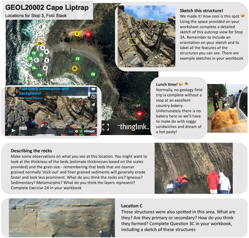
Figure 2. Examples of materials available to students taking the Level 2 volcanic landforms and igneous processes (GEOL20003) virtual field excursion at the University of Melbourne. (a) Waypoints for localities on the Harman’s Valley lava flows and their source, Mt Napier, in the Newer Volcanics Province of western Victoria. (b) Photograph of Mt Napier and the Harman’s Valley flows taken from Harman’s Valley Lookout waypoint in (a), with scale and direction to be inferred by students. Students were required to sketch the margin of the Harman’s Valley flow series as they interpreted it from Google Earth (the margin is visible, unmarked, in ), to deduce and demonstrate how the younger flows follow a river valley that cuts through older lavas. (c) View of Mt Napier’s scoria cone from Google Earth. (d) Photograph of a tumulus found in the Harman’s Valley lava flows at the waypoint shown in (a). Students characterized the shape of Mt Napier to help deduce its origin and investigated a series of sinkhole-like features in the Harman’s Valley based on their geomorphology to evaluate hypotheses regarding the nature of tumuli in the lava flow.
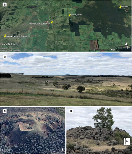
Figure 3. Pooled results of an informal student survey of Level 2 and Level 3 structural geology students who took the GEOL20002 and GEOL30002 virtual excursions in 2020. Note that as they had not previously had in-person field experience, only Level 2 students were asked about their level of confidence in approaching site fieldwork.
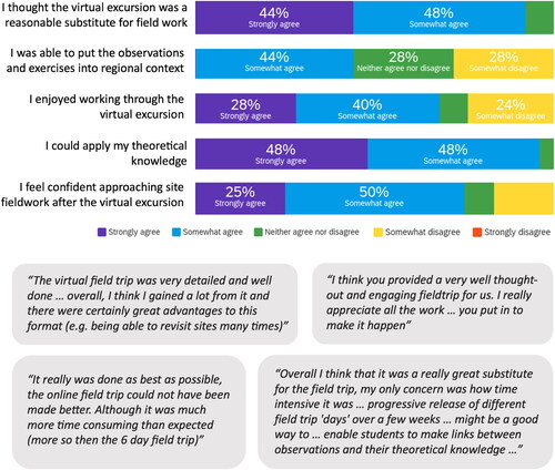
Table 1. Advantages of virtual excursions as reported by level 2 and level 3 structural geology students at the University of Melbourne in 2020.
Figure 4. University of Melbourne Level 3 and Level 2 structural geology student responses to the reflective prompt to “draw our class on a virtual excursion,” with most responses highlighting the sense of isolation many students felt working through the assignment.
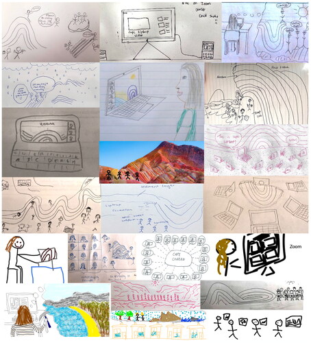
Table 2. Disadvantages of virtual excursions as reported by level 2 and level 3 structural geology students at the University of Melbourne in 2020.
Figure 5. Representative student feedback was received on (a) the Level 1 Earth, Atmosphere and Environment virtual excursion at Monash University (subject code EAE1022) and (b) the Level 2 volcanic landforms excursion at The University of Melbourne (subject code GEOL20003) in 2020.
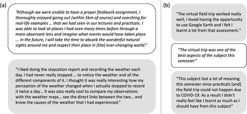
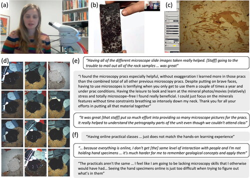
Figure 6. Petrology and petrography teaching. (a) At Monash University and at The University of Melbourne, staff took home a microscope with camera attached, which enabled live demonstration of the properties of minerals down a microscope during classes; (b) Staff used high-resolution document cameras to demonstrate minerals and textures in rocks. At Monash University, students were posted the rock samples so they could use the videos to find the features in their own samples; (c) Image of the camera feed from the microscope during a synchronous online practical session; (d) Example of thin section images provided to students: for each field of view the stage was rotated through 90° with an image taken every 10° in plane polarized light and in cross-polarized light, producing 20 images. Here all photomicrographs are in cross-polarized light except the first and last, which are in plane-polarized light; (e) Representative positive student feedback from petrography classes; (f) Representative negative student feedback from petrography classes.