
Figures & data
Table 1. Lithofacies codes (first-, second- and third-order code system) as used in this work, notably in Figures , , , and . Basic system according to Eyles et al. (Citation1983).
Figure 1. Hill shaded DSM of ribbed moraine in the Niemisel area, province of Norrbotten. A. The Lake Valvträsket area. B. The Lake Inre-Fällträsket area, ~22 km to the SE of area (A). Colour coding is from ~150 (reddish) to 30 (grey-bluish) m a.s.l. Violet arrows SE of Lake Valvträsket (A) point towards a set of De Geer moraine ridges, partly draping Niemisel moraine ridges. Larger De Geer moraines are marked, and are typically 200–350 m apart. Smaller ones, only 30–75 m apart, lie between the larger ones. Red arrows in (A) indicate the position for sections shown in Figure . The red dot on the inset map in the upper right corner of (A) shows the location of the area in a regional context. The inset frame in the lower right corner of (A) shows the most similar-looking planform in the Dunlop and Clark (Citation2006) classification of ribbed moraine, which is “broad arcuate ribbed moraine ridges” [redrawn from Figure 17 in Dunlop & Clark (Citation2006)]. C. Transect across Niemisel moraine ridges (red arrows) and De Geer moraine ridges (violet arrows) SE of Lake Valvträsket (red line in (A)). D. Transect across preferentially Niemisel moraine ridges (red arrows), but also De Geer moraine ridges (violet arrows) south of Lake Inre-Fallträsket (red line in (B)). LiDAR data provided by Lantmäteriverket, Sweden; ©Lantmäteriverket i212/927.
![Figure 1. Hill shaded DSM of ribbed moraine in the Niemisel area, province of Norrbotten. A. The Lake Valvträsket area. B. The Lake Inre-Fällträsket area, ~22 km to the SE of area (A). Colour coding is from ~150 (reddish) to 30 (grey-bluish) m a.s.l. Violet arrows SE of Lake Valvträsket (A) point towards a set of De Geer moraine ridges, partly draping Niemisel moraine ridges. Larger De Geer moraines are marked, and are typically 200–350 m apart. Smaller ones, only 30–75 m apart, lie between the larger ones. Red arrows in (A) indicate the position for sections shown in Figure 3. The red dot on the inset map in the upper right corner of (A) shows the location of the area in a regional context. The inset frame in the lower right corner of (A) shows the most similar-looking planform in the Dunlop and Clark (Citation2006) classification of ribbed moraine, which is “broad arcuate ribbed moraine ridges” [redrawn from Figure 17 in Dunlop & Clark (Citation2006)]. C. Transect across Niemisel moraine ridges (red arrows) and De Geer moraine ridges (violet arrows) SE of Lake Valvträsket (red line in (A)). D. Transect across preferentially Niemisel moraine ridges (red arrows), but also De Geer moraine ridges (violet arrows) south of Lake Inre-Fallträsket (red line in (B)). LiDAR data provided by Lantmäteriverket, Sweden; ©Lantmäteriverket i212/927.](/cms/asset/0a059d12-a81e-410e-8480-23bb3dfaebad/sgff_a_1441903_f0001_oc.gif)
Table 2. Summary statistics on ribbed moraine from the Niemisel (Fig. ), Indor (Fig. ) and Åsnen (Fig. ) areas.
Figure 2. Niemisel-type ribbed moraine architecture [rearranged from Lindén et al. (Citation2008)]. A. The three identified architectural elements, repeated in varying dimensions in all studied sections. B. Sequential formation model for Niemisel-type ribbed moraine. Ridge formation is illustrated in five stages. Pre-ridge formation stage, T0 – A subglacial depositional system acting prior to individual ridge formation (unknown age) with accretion of both sorted sediments and massive and tectonically laminated diamicts and glaciotectonites. This pre-ridge formation stage gave rise to thick (metres to tens of metres scale), subhorizontally laminated sediment sequences, preferentially deposited in the valley areas. The initiation stage, T1 – The initiation of ridge formation is marked by a localised change from bed extension to bed compression. Previously deposited sediments were either folded (T1A) or thrust (T1B) along lineaments perpendicular to the ice flow and stress direction that caused a transverse thickening of the bed, a proto-ridge, from which the final landform developed. The proto-ridge formed an obstacle to glacier flow and a lee-side cavity (cf. Boulton Citation1982) parallel to the ridge developed. Ridge formation stages, T2 and T3 – Initial folding was followed by repetitive erosional events and thrust sheet (nappes) stacking of sediment (T2A) or by a continuous process of sediment thrust-fault stacking (T2B). With Proximal Element growth in the vertical and proximal direction, the lee-side cavity also grew in a vertical and distal direction. Distal cavity infilling in stages T2 and T3 was characterised by repetitive deposition of meltwater-transported sediments in a highly varying depositional system, including suspension settling of fine-grained sediment to high flow-velocity gravels of traction load, all interbedded with stratified and massive diamicts deposited from sediment gravity flows introduced into the lee-side cavity by the deforming bed conveyor belt. The draping stage, T4 – A late stage smoothing of the transverse ridge at which both proximal and distal ridge sediments were eroded, as demarcated by a major angular unconformity at the base of the Draping Element. The Draping facies diamicts were deposited with varying thicknesses from a deforming bed during brittle-ductile shear with highly developed clast orientation in deposited till and lodgement of ploughing boulders.
![Figure 2. Niemisel-type ribbed moraine architecture [rearranged from Lindén et al. (Citation2008)]. A. The three identified architectural elements, repeated in varying dimensions in all studied sections. B. Sequential formation model for Niemisel-type ribbed moraine. Ridge formation is illustrated in five stages. Pre-ridge formation stage, T0 – A subglacial depositional system acting prior to individual ridge formation (unknown age) with accretion of both sorted sediments and massive and tectonically laminated diamicts and glaciotectonites. This pre-ridge formation stage gave rise to thick (metres to tens of metres scale), subhorizontally laminated sediment sequences, preferentially deposited in the valley areas. The initiation stage, T1 – The initiation of ridge formation is marked by a localised change from bed extension to bed compression. Previously deposited sediments were either folded (T1A) or thrust (T1B) along lineaments perpendicular to the ice flow and stress direction that caused a transverse thickening of the bed, a proto-ridge, from which the final landform developed. The proto-ridge formed an obstacle to glacier flow and a lee-side cavity (cf. Boulton Citation1982) parallel to the ridge developed. Ridge formation stages, T2 and T3 – Initial folding was followed by repetitive erosional events and thrust sheet (nappes) stacking of sediment (T2A) or by a continuous process of sediment thrust-fault stacking (T2B). With Proximal Element growth in the vertical and proximal direction, the lee-side cavity also grew in a vertical and distal direction. Distal cavity infilling in stages T2 and T3 was characterised by repetitive deposition of meltwater-transported sediments in a highly varying depositional system, including suspension settling of fine-grained sediment to high flow-velocity gravels of traction load, all interbedded with stratified and massive diamicts deposited from sediment gravity flows introduced into the lee-side cavity by the deforming bed conveyor belt. The draping stage, T4 – A late stage smoothing of the transverse ridge at which both proximal and distal ridge sediments were eroded, as demarcated by a major angular unconformity at the base of the Draping Element. The Draping facies diamicts were deposited with varying thicknesses from a deforming bed during brittle-ductile shear with highly developed clast orientation in deposited till and lodgement of ploughing boulders.](/cms/asset/a619b97c-f44c-47fc-b389-bce6b37f51c0/sgff_a_1441903_f0002_b.gif)
Figure 3. A. Proximal slope of a Niemisel moraine ridge at the Gunnarsbyn site (Lindén et al. Citation2008), displaying the typical architecture of the “proximal ridge element” sediment facies association; the primary sediments overprinted post-depositional glaciotectonic deformation. The lower part of the section shows interbedded silt, fine sand and gravelly sand, all folded into an isoclinal fold and cut by a major thrust plane, above which is a sequence of folded and stacked thrust sets of gravelly sand. A few bedding surfaces are enhanced by hatched white lines and thrust surfaces with red arrows. The section is perpendicular to the ridge crest, and the ice stress direction during deformation was from the NW. B. Distal part of a Niemisel moraine ridge at the site Rörån 1 (Lindén et al. Citation2008) displaying some typical “distal ridge element” sediment facies associations (DRF), sediment deposited within a lee-side cavity to the proto-ridge formed from folding and thrusting of the “proximal ridge element” sediments. The section, which is perpendicular to the ridge crest line, shows interbedded units of fine sand and silt (dominant) but also gravel beds and occasional silty diamicts, all beds with considerable lateral continuity. At the top is a massive diamict, forming the “draping element” of the ridge architecture (DF). The depositional direction was from left to right. Note the large drop boulder in the centre of the section, deposited from the cavity roof. Measuring sticks are 4-m tall.
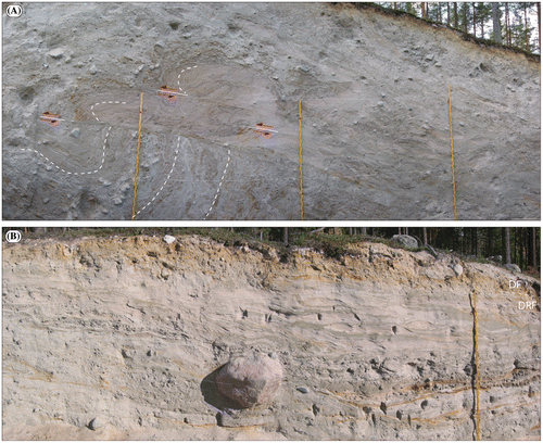
Figure 4. The highly crescentic shaped Rogen-type ribbed moraine in the Indor Valley (Fig. ) with horns pointing in the ice-flow direction (right), which is towards the SE.
Figure 5. Hill shaded DSM of ribbed moraine in the Indor valley, province of Dalarna. Note the very pronounced horns in the centre of the valley – that is, “classic” Rogen moraine planform – and the surface, clearly streamlined from the NW, over the moraines in the south central part of the DSM (marked by arrows in the ice-flow direction), eventually leading to ice-flow parallel forms. The red arrow marks the three ribbed moraines in Lake Indsjön, as depicted in Figure . Red lines marked (a) and (b) show the locations of cross-moraine trenches in mid-ridge (a) and horn (b) positions. Colour coding in the DSM is from ~400 (reddish) to 250 (greyish) m a.s.l. The red dot in upper right corner of the inset map shows the location of the Indor area in a regional context. The inset frame in the upper left corner shows the most similar-looking planform in the Dunlop & Clark (Citation2006) classification of ribbed moraine, which is “downstream-curving ribbed moraine ridges” [redrawn from Figure 17 in Dunlop & Clark (Citation2006)]. LiDAR data provided by Lantmäteriverket, Sweden; ©Lantmäteriverket i212/927.
![Figure 5. Hill shaded DSM of ribbed moraine in the Indor valley, province of Dalarna. Note the very pronounced horns in the centre of the valley – that is, “classic” Rogen moraine planform – and the surface, clearly streamlined from the NW, over the moraines in the south central part of the DSM (marked by arrows in the ice-flow direction), eventually leading to ice-flow parallel forms. The red arrow marks the three ribbed moraines in Lake Indsjön, as depicted in Figure 4. Red lines marked (a) and (b) show the locations of cross-moraine trenches in mid-ridge (a) and horn (b) positions. Colour coding in the DSM is from ~400 (reddish) to 250 (greyish) m a.s.l. The red dot in upper right corner of the inset map shows the location of the Indor area in a regional context. The inset frame in the upper left corner shows the most similar-looking planform in the Dunlop & Clark (Citation2006) classification of ribbed moraine, which is “downstream-curving ribbed moraine ridges” [redrawn from Figure 17 in Dunlop & Clark (Citation2006)]. LiDAR data provided by Lantmäteriverket, Sweden; ©Lantmäteriverket i212/927.](/cms/asset/60f0eabe-0c79-43e8-a77f-2f3df969daec/sgff_a_1441903_f0005_oc.gif)
Figure 6. Example of vertical sediment succession in the central part of a side-to-side cross section over a Rogen-shaped moraine ridge in the middle ridge position [section marked (a) in Fig. ], representative of the whole section except for the distal slope. In the distal slope, the bedding instead of being in a subhorizontal position, the same types of sediments start to be inclined in the slope direction and individual beds show anticlinal/synclinal bending with dips of up to 70°. The subhorizontal bedding of the main part of the section continues towards the proximal slope of the ridge and is cut here at a considerable angle by the sloping ridge surface. Lithofacies codes are according to Table . Clast fabric data are plotted on Schmidt equal-area, lower hemisphere projections of clast long-axis orientation and contoured according to the Kamb method at 2σ intervals. The calculated strongest eigenvector azimuth (V1) and its eigenvalue (S1) for each data-set are according to Mark (Citation1973). Redrawn from part of Figure 5 in Möller (Citation2006).
![Figure 6. Example of vertical sediment succession in the central part of a side-to-side cross section over a Rogen-shaped moraine ridge in the middle ridge position [section marked (a) in Fig. 5], representative of the whole section except for the distal slope. In the distal slope, the bedding instead of being in a subhorizontal position, the same types of sediments start to be inclined in the slope direction and individual beds show anticlinal/synclinal bending with dips of up to 70°. The subhorizontal bedding of the main part of the section continues towards the proximal slope of the ridge and is cut here at a considerable angle by the sloping ridge surface. Lithofacies codes are according to Table 1. Clast fabric data are plotted on Schmidt equal-area, lower hemisphere projections of clast long-axis orientation and contoured according to the Kamb method at 2σ intervals. The calculated strongest eigenvector azimuth (V1) and its eigenvalue (S1) for each data-set are according to Mark (Citation1973). Redrawn from part of Figure 5 in Möller (Citation2006).](/cms/asset/2c5b5693-2ed3-459f-bc7b-40244495db51/sgff_a_1441903_f0006_oc.gif)
Figure 7. Reshaping of precursor ridges into Rogen-shape ribbed moraine, which varies from very little (slight bending of just one ridge end for ridges in a valley-lateral position) to “boomerang” reshaping, often on ridges in a more central valley position, to total reshaping of pre-existing bed morphology into streamlined terrain (drumlins). The sequential model depicts seven steps (I–VII) with gradual reshaping with time of the pre-existing planform to the right (the line arrows depict flow-line adjustment to the bedform). In the middle are the time-arbitrarily chosen vertical, parallel to ice-flow cross profiles, (A) over the central part of the precursor ridge and (B) over the end-part of the precursor ridge, with the principal vertical velocity distribution in the sediment (deforming sediment; grey shaded) to ice–bed interface sliding to internal ice deformation (white, non-shaded) on the left in the right column and the deforming sediment strain rate on the right in the right-hand column for profiles (A) and (B), respectively (grey shaded). Pre-deformation stage, I. – The precursor ridge is beneath a frozen ice–bed interface. Sediments are in a frozen state, with no basal ice sliding and sub-bed deformation. Deformation stages II–III. – As the ice margin approaches during the LGM deglaciation of the area, the ice–bed interface changes to a wet-based one; sediment starts to deform mainly at the end parts of the precursor ridge with ductile deformation at high strain rates and deflection of sediment in the down-ice direction, while there is very limited deformation of sediment along a flow line at the mid-ridge position. Deformation stages IV–V. – Deformation continues with time, preferentially located at the precursor ridge end-point at enhanced ice anddeforming bed velocity and strain compared with that over mid-ridge parts, with the crescentic planform enhanced over time. Remoulding stops with deglaciation, that is, leaving more or less remoulded forms in front of the receding ice margin. Deformation stages VI–VII. – If remoulding is not interrupted by deglaciation, it continues with, as a final result, total reorganisation of the pre-existing bed into ice-parallel streamlined landforms (drumlins) as seen in the lower right corner of the DSM in Figure . Reprint of Figure 14 in Möller (Citation2006).
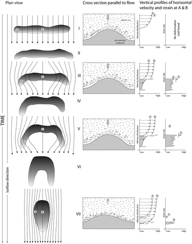
Figure 8. Hill shaded DSM of ribbed moraine in the lake Åsnen area, County of Småland. Colour coding is from ~200 (reddish) to 140 (grey-bluish) m a.s.l. The red dot in the lower right corner of the inset map shows the location of the area in a regional context. The inset frame in the upper left corner shows the most similar-looking planform in the Dunlop and Clark (Citation2006) classification of ribbed moraine, which is “anastomosing ribbed moraine ridges” [redrawn from Figure 17 in Dunlop & Clark (Citation2006)]. LiDAR data provided by Lantmäteriverket, Sweden; ©Lantmäteriverket i212/927.
![Figure 8. Hill shaded DSM of ribbed moraine in the lake Åsnen area, County of Småland. Colour coding is from ~200 (reddish) to 140 (grey-bluish) m a.s.l. The red dot in the lower right corner of the inset map shows the location of the area in a regional context. The inset frame in the upper left corner shows the most similar-looking planform in the Dunlop and Clark (Citation2006) classification of ribbed moraine, which is “anastomosing ribbed moraine ridges” [redrawn from Figure 17 in Dunlop & Clark (Citation2006)]. LiDAR data provided by Lantmäteriverket, Sweden; ©Lantmäteriverket i212/927.](/cms/asset/5e2c3015-c163-45a7-aac2-fec0230fc48c/sgff_a_1441903_f0008_oc.gif)
Figure 9. Synthesised log of sedimentary units A–C and sediment facies in the Horgeboda ribbed moraine section. Lithofacies codes are according to Table . Clast fabric data are plotted on Schmidt equal-area, lower hemisphere projections of clast long-axis orientation and contoured according to the Kamb method at 2σ intervals. The calculated strongest eigenvector azimuth (V1) and its eigenvalue (S1) for each data-set are according to Mark (Citation1973). Reproduced from Möller & Dowling (Citation2015).
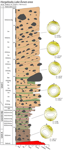
Figure 10. A conceptual model of ice dynamic and palaeoenvironmental change, with emphasis on spatial and temporal changes at the ice–bed interface as an explanatory tool for landscape evolution for the broad E–W-trending zone of hummocky and ribbed moraine across south Småland and the streamlined terrain north thereof. For an in-depth discussion of the processes, see Möller (Citation2010) and Möller & Dowling (Citation2015). Panel explanation: Panel A. – Wet-bedded conditions during deglaciation all the way to the ice margin (process zone A; PZ-A), the latter situated in a subaqueous position with ablation as calving into the Baltic Ice Lake in the south. Panel B. – The hummocky and ribbed moraine area, starting just above the highest shoreline, suggests a major and regional shift in the basal thermal regime from wet-based to freezing-on conditions (process zone B; PZ-B) in a frontal zone of the ice sheet, a prerequisite for basal entrainment of glacial debris that is arranged in debris-charged zones transverse to the ice-flow and stress direction due to differential folding and thrusting and incremental stagnation. Panel C. – The marginal zone gradually turned into a frozen-bed zone with the ice–bed interface below the pressure melting point and no basal sliding (process zone C; PZ-C). In this stage, PZ-B formed an intermediate zone to PZ-A, propagating backwards, that is, in the proximal direction to the ice flow, building a polythermal ice margin. The distal boundary of PZ-B coincides with what we define as the “activity limit” (Lagerlund et al. Citation1983), which is the most distal boundary of basal activity along the ice–bed interface at a given time. Localised compressive flow within PZ-B is suggested to have led to enhanced folding and thrusting of debris-rich ice and zonal thickening (density zonation), more or less transverse to the stress directions, eventually leading to the formation of ribbed moraine “embryos”. These could later, after incremental stagnation, melt out in situ, forming “Åsnen-type” ribbed moraine (Möller, Citation2010) (see below). Panel D. – With continued recession of PZ-B, the ice surface was lowered due to surface ablation until debris-rich ice was encountered; as debris melted out, a protective cover [supraglacial ablation complex; e.g., Shaw (Citation1979)] formed, causing a drastic slowdown of further melting. The combination of lowering of the ice surface and recession of the PZ-A/PZ-B boundaries led to a successively larger area of stagnant, debris-charged ice with ice below the pressure-melting point (PZ-C) in front of the receding activity limit. Panel E. – During the final melting of the stagnant-ice zone was an in situ melt-out of the ribbed moraine “embryos”. Their survival as melt-out till ridges was highly dependent on the release and redistribution styles (or the absence of the latter) of sediment from the stagnant ice. Reprint of Figure 20 in Möller & Dowling (Citation2015).
![Figure 10. A conceptual model of ice dynamic and palaeoenvironmental change, with emphasis on spatial and temporal changes at the ice–bed interface as an explanatory tool for landscape evolution for the broad E–W-trending zone of hummocky and ribbed moraine across south Småland and the streamlined terrain north thereof. For an in-depth discussion of the processes, see Möller (Citation2010) and Möller & Dowling (Citation2015). Panel explanation: Panel A. – Wet-bedded conditions during deglaciation all the way to the ice margin (process zone A; PZ-A), the latter situated in a subaqueous position with ablation as calving into the Baltic Ice Lake in the south. Panel B. – The hummocky and ribbed moraine area, starting just above the highest shoreline, suggests a major and regional shift in the basal thermal regime from wet-based to freezing-on conditions (process zone B; PZ-B) in a frontal zone of the ice sheet, a prerequisite for basal entrainment of glacial debris that is arranged in debris-charged zones transverse to the ice-flow and stress direction due to differential folding and thrusting and incremental stagnation. Panel C. – The marginal zone gradually turned into a frozen-bed zone with the ice–bed interface below the pressure melting point and no basal sliding (process zone C; PZ-C). In this stage, PZ-B formed an intermediate zone to PZ-A, propagating backwards, that is, in the proximal direction to the ice flow, building a polythermal ice margin. The distal boundary of PZ-B coincides with what we define as the “activity limit” (Lagerlund et al. Citation1983), which is the most distal boundary of basal activity along the ice–bed interface at a given time. Localised compressive flow within PZ-B is suggested to have led to enhanced folding and thrusting of debris-rich ice and zonal thickening (density zonation), more or less transverse to the stress directions, eventually leading to the formation of ribbed moraine “embryos”. These could later, after incremental stagnation, melt out in situ, forming “Åsnen-type” ribbed moraine (Möller, Citation2010) (see below). Panel D. – With continued recession of PZ-B, the ice surface was lowered due to surface ablation until debris-rich ice was encountered; as debris melted out, a protective cover [supraglacial ablation complex; e.g., Shaw (Citation1979)] formed, causing a drastic slowdown of further melting. The combination of lowering of the ice surface and recession of the PZ-A/PZ-B boundaries led to a successively larger area of stagnant, debris-charged ice with ice below the pressure-melting point (PZ-C) in front of the receding activity limit. Panel E. – During the final melting of the stagnant-ice zone was an in situ melt-out of the ribbed moraine “embryos”. Their survival as melt-out till ridges was highly dependent on the release and redistribution styles (or the absence of the latter) of sediment from the stagnant ice. Reprint of Figure 20 in Möller & Dowling (Citation2015).](/cms/asset/91b346a3-54af-4fcb-9866-7d260e016cb9/sgff_a_1441903_f0010_oc.gif)
Figure 11. Results of the morphometric analyses carried out on the three ribbed moraine locations. Åsnen is in red (+), Indor in blue (x) and Niemisel in black (*). All values were rounded to two decimal places before the analyses were carried out. A. Histogram of ribbed moraine length (m) with frequency normalised to 1. B. Histogram of ribbed moraine width (m) with frequency normalised to 1. C. Histogram of ribbed moraine height (m) with frequency normalised to 1. D. A plot of ribbed moraine length versus width with all values log-normalised. E. A plot of ribbed moraine width versus height with all values log-normalised. F. A plot of length versus width versus height with all values log-normalised.
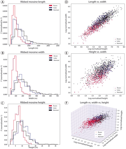
Figure 12. Hill shaded DSM of drumlins on Vemboö within Lake Åsnen; drumlins are all of the rock-cored type. Some of the protruding rock nobs are marked by white arrows. Colour coding is from ~190 (reddish) to 140 (blue greyish) m a.s.l. The red dot in the lower right corner of the inset map shows the location of the area in a regional context. LiDAR data provided by Lantmäteriverket, Sweden; ©Lantmäteriverket i212/927.
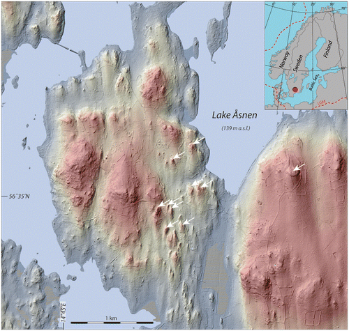
Figure 13. Hill shaded DSM of drumlins on the Gö peninsula, south-central Blekinge; drumlins are all of the rock-cored type. Colour coding is from ~30 (reddish) to 0 (Baltic Sea) m a.s.l. LiDAR data provided by Lantmäteriverket, Sweden; ©Lantmäteriverket i212/927.
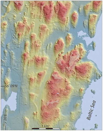
Figure 14. Sediment succession in the lee-side position (south) of a bedrock ridge at Järnavik in coastal Blekinge, an area with streamlined terrain with all drumlins being of the rock-cored type (Fig. ). Section redrawn from part of the originally 35-m long section described in Nilsson (Citation1996); the sediments are divided into five stratigraphic units (A–E). The ground surface is ~20 m a.s.l. Facies codes are according to Table .
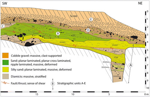
Figure 15. Hill shaded DSM of streamlined terrain with soft-core drumlins around Hackvad (Hackvad church is marked by the white dot) on the Närke Plain, south central Sweden (the red dot in the upper left corner of the inset map shows the location of the area in a regional context). Colour coding is from ~90 (reddish) to 41 (bluish) m a.s.l. White ovals mark the positions of cross-ridge trenches performed (left: the Västergården (V) drumlin; right: the Hullingsåsen (H) drumlin), reported in Möller and Dowling (Citation2016). LiDAR data provided by Lantmäteriverket, Sweden; ©Lantmäteriverket i212/927.
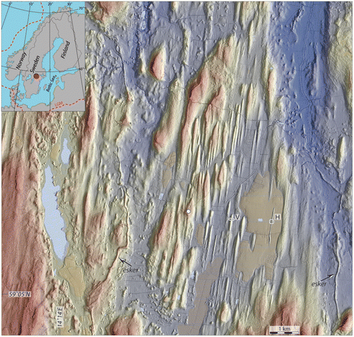
Figure 16. A. Hill shaded DSM of the isolated sediment-cored Grimslöv–Ströby drumlin, rising 12 m above the surrounding glacial lake plain deposits (NE corner of Lake Åsnen, south-central Småland). Colour coding is from ~160 (reddish) to 140 (blue) m a.s.l. The white circle in the northern tip of the drumlins marks an excavated section of the drumlin (Fig. ); the white dot marks the position of a core drilling through the drumlin sediments (43 m to bedrock). LiDAR data provided by Lantmäteriverket, Sweden; ©Lantmäteriverket i212/927. B. Sediment log from the trench marked by the white circle in (A), showing glaciotectonically displaced glaciolacustrine sediments below a draping till. Lithofacies codes according to Table . Green planes in stereonet indicate strike and dip of high-angle bedding surfaces, while the red plane represents strike and dip of the thrust plane in the lower part of the section. Glaciotectonic stress was from the NNW. OSL ages are according to Möller & Murray (Citation2015).
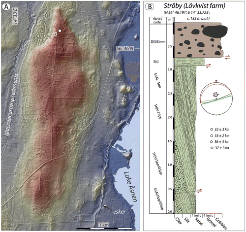
Figure 17. Glaciolacustrine sediment sequence forming the core of the Grimslöv–Ströby drumlin (Fig. ). The sediments are glaciotectonically folded from the NNW (drumlin axis N–S); shown section is the right limb of an isoclinal fold (up of the sediment sequence is to the right) with primary bed contacts standing close to vertically. The fold is cut off by glacial erosion; the sediments beneath the horizontal shear surface (hatched white line) display shear lamination in a 10–15-cm-thick horizon, and below these are small-scale drag folds. On top is a ~0.7-m-thick diamict, interpreted as a subglacial traction till. This till forms a carapace, draping the sorted sediment core of the drumlin. OSL ages of the glaciolacustrine sediments are between 32 and 37 ka (n = 4). Per Möller for scale is 1.68 m.
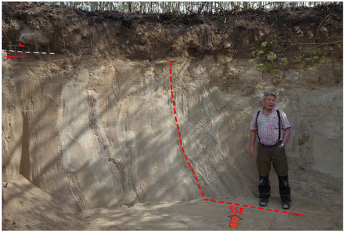
Figure 18. Hill shaded DSM of streamlined terrain imprinted on widely distributed glaciofluvial sediments between Lake Rymmen and Rydaholm, ~35 km WNW of Växjö, south-central Småland (the red dot in the upper left corner of the inset map shows the location of the area in a regional context). Colour coding is from ~250 (reddish) to 160 (bluish) m a.s.l. The streamlined higher terrain is bounded to the north by a 10–20 m high scarp to lower terrain, and to the SW the streamlined plateau is cut by a 0.8–1-km-wide and~30-m-deep valley hosting a glaciofluvial esker train [resembling the “hummocky corridors” of Peterson et al. (Citation2017, Citation2018)]. The white dot indicates the position of a core drilling performed recently at Upplid, reaching 18 m below the ground surface. The white circle (R) is the position of a logged sediment trench (inset in lower right corner) with OSL ages according to Möller & Murray (Citation2015). LiDAR data provided by Lantmäteriverket, Sweden; ©Lantmäteriverket i212/927.
![Figure 18. Hill shaded DSM of streamlined terrain imprinted on widely distributed glaciofluvial sediments between Lake Rymmen and Rydaholm, ~35 km WNW of Växjö, south-central Småland (the red dot in the upper left corner of the inset map shows the location of the area in a regional context). Colour coding is from ~250 (reddish) to 160 (bluish) m a.s.l. The streamlined higher terrain is bounded to the north by a 10–20 m high scarp to lower terrain, and to the SW the streamlined plateau is cut by a 0.8–1-km-wide and~30-m-deep valley hosting a glaciofluvial esker train [resembling the “hummocky corridors” of Peterson et al. (Citation2017, Citation2018)]. The white dot indicates the position of a core drilling performed recently at Upplid, reaching 18 m below the ground surface. The white circle (R) is the position of a logged sediment trench (inset in lower right corner) with OSL ages according to Möller & Murray (Citation2015). LiDAR data provided by Lantmäteriverket, Sweden; ©Lantmäteriverket i212/927.](/cms/asset/402a8758-7138-465e-9c49-0a0f90ddd89a/sgff_a_1441903_f0018_oc.gif)