
Figures & data
Figure 1. Alpine and subalpine peaks in New Hampshire included in the study’s focal area. From Sperduto and Kimball (Citation2011). Courtesy of New Hampshire Natural Heritage Bureau, Concord.
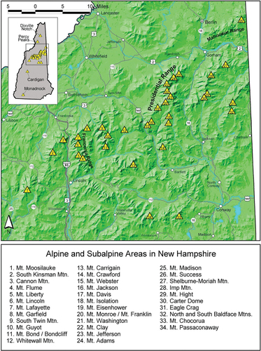
Figure 2. (Top) Alpine tundra (brownish-white background) on Mt. Washington, New Hampshire. Generally, the Auto Road runs from the northeast corner (upper right) to the summit (center) and the Cog Railway from the west edge (left) to the summit; Lakes of the Clouds Hut is near the southwest corner (near lower edge and left of center). Credit: USA Topo Maps, 2013 National Geographic Society. (Bottom) Structures, parking lots, and other disturbed areas on the summit of Mt. Washington, New Hampshire. Credit: 2010–11 Statewide High Resolution Aerial Photography, NH GRANIT, University of New Hampshire, Durham.
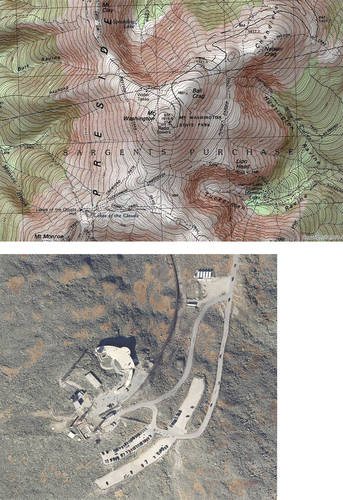
Figure 3. (Top left) Donkeys at Madison Springs Hut (right side), Mt. Madison, New Hampshire (circa 1941 or later). (Top right) Burros (donkeys) used to pack materials to Madison Springs Hut in the lowlands of Randolph, New Hampshire. (Bottom left) Donkey and driver in an alpine meadow; drivers let donkeys forage on natural vegetation rather than packing in hay or feed. (Bottom right) Crew and horses at Lakes of the Clouds Hut still under construction in the early twentieth century. Credit: Postcards by Guy Shorey Studio, Gorham, New Hampshire. Courtesy of Appalachian Mountain Club Library & Archives and Gladys Brooks Memorial Library, Mt. Washington Observatory Weather Discovery Center, North Conway, New Hampshire.
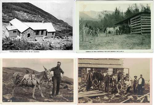
Figure 4. Schematic map of Lakes of the Clouds Hut and associated outbuildings (as they were in 2003) at 1,539 m elevation between Mt. Washington and Mt. Monroe, New Hampshire. Five widespread non-native forbs were visually mapped onto a schematic of the hut and its outbuildings in 2003 and were resurveyed with GPS in 2020. Visible aboveground structures are shown as black boxes; the perimeter of each was searched. To evaluate distributional and compositional change, twelve zones were designated corresponding to 25-m bands from the geometric center of the main hut.
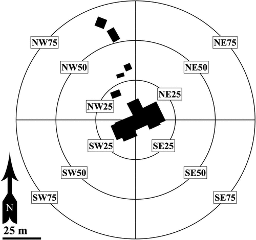
Figure 5. Cumulative species richness over time on Mt. Washington, New Hampshire. There were two primary periods of documentation, from 1874 to 1903 and from ~1990 to present.
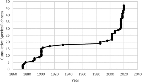
Table 1. Non-native vascular plant species composition of alpine and exposed subalpine areas in New Hampshire, USA.
Figure 6. Species richness of non-native plants along the margins of the alpine portion of the Mt. Washington Auto Road (teal line) in fourteen segments spanning 50-m elevation each (New Hampshire). Richness of each segment is indicated in circles along a color gradient. Building complexes and corresponding richness are indicated for the summit of Mt. Washington and the Lakes of the Clouds Hut (star). Trails are denoted by dashed tan lines.
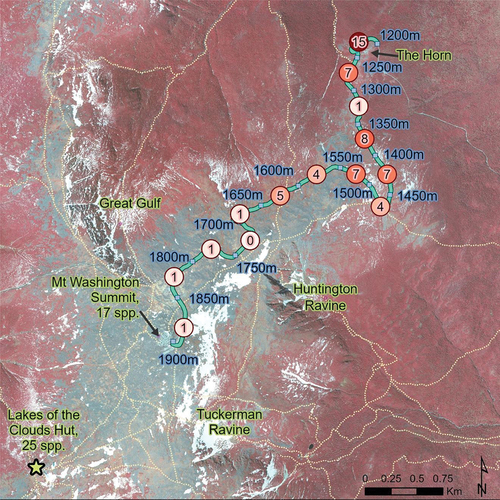
Table 2. Composition and richness of non-native species along the Mt. Washington Auto Road (New Hampshire), sorted by frequency.
Figure 7. Linear regression of midpoint elevation of fourteen 50-m elevation roadway segments from 1,200 to 1,900 m on Mount Washington, New Hampshire, against extant (2020–2021) non-native species richness.
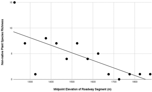
Figure 8. Linear regression of site elevation (m) against non-native species richness (S) divided by the total area of disturbed nonimpervious habitat (ha) for five building complexes above or near tree line in the White Mountains, New Hampshire: (A) Greenleaf Hut, (B) Madison Springs Hut, (C) Lakes of the Clouds Hut, (D) Mount Washington Storage Tanks, and (E) Mount Washington Summit Complex.
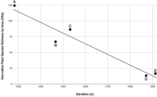
Table 3. Sørensen similarity index values (Index) comparing non-native species composition of the White Mountains, New Hampshire, to nineteen other global alpine areas.
Figure 9. NMS ordination of twenty global alpine sites in PC-ORD software (McCune and Mefford Citation2018) using a medium level of iterations and Sørensen (Bray-Curtis) distance measure settings. For region abbreviations, see .
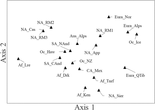
Table 4. Non-native species documented from three or more global alpine regions.
Figure 10. Distribution of five non-native species at Lakes of the Clouds Hut (New Hampshire), visually mapped in 2003 and resurveyed with GPS in 2020: Pilosella aurantiaca, Matricaria discoidea, Ranunculus acris, Stellaria media, and Taraxacum officinale. The bands are 25 m apart and the outermost boundary is 75 m from the geometric center of the main hut. In both years the greatest species richness of non-native species occurred in the northwest quadrant in association with the septic outflow, food compost, and propane storage areas. Taraxacum officinale and R. acris also occur immediately outside the 75-m band to the northwest, and T. officinale is established near the upper lake of the Lakes of the Clouds, 175 m E/NE of the hut.
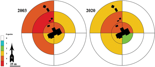
Table 5. Generalized distribution and apparent net distributional change of eleven non-native forb species recorded in 2003 and 2020 at Lakes of the Clouds Hut, located between Mt. Washington and Mt. Monroe, New Hampshire.