Figures & data
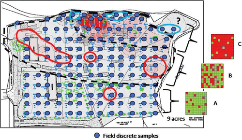
Figure 1. Discrete sampling grid designated for a site under investigation overlaid with hypothetical “hot spots” superimposed (USEPA, Citation1989a). Under this approach, an individual discrete soil sample was assumed to be adequate to identify large areas of contamination above potential levels of concern.
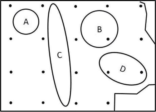
Table 1. Range and sum of intra-sample and inter-sample relative standard deviation (RSD) of discrete sample variability around individual grid points (refer to Part 1 Supporting Information).
Figure 2. Box plots depicting estimated total variability of lead concentrations in discrete samples within 0.5 m of grid points at Study Site B (lowest to highest median for inter-sample data). Estimated range of lead concentrations falls both above and below HDOH residential soil action level of 200 mg/kg at 23 of 24 grid points and above USEPA residential screening level of 400 mg/kg at 20 of 24 points. HDOH default, upper background lead level of 75 mg/kg indicated for reference with full range of lead concentrations points reflecting the presumed mixture of native fill and lead-contaminated ash.
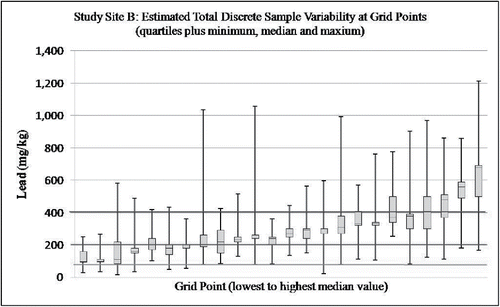
Figure 3. Box plots depicting estimated total variability of total PCB concentrations in discrete samples within 0.5 m of grid points at Study Site C (combined intra- and inter-sample variability; note use of log scale for vertical axis; lowest to highest median values for inter-sample data). Hawaii Department of Health Residential PCB soil screening level of 1.1 mg/kg and USEPA TSCA level of 50 mg/kg noted for reference.
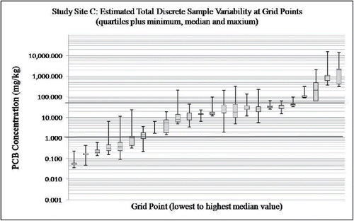
Figure 4. Irregular and disconnected spill patterns on soil made by a release of milk. This might also mimic vertical patterns for subsurface releases of liquids.
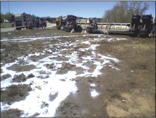
Figure 5. Changing locations of isolated “hot spots” and “cold spots” depending on use of arsenic data for “A,” “B,” “C,” “D,” or “E” processed sample sets for Study Site A (Groundswell Technologies, Inverse Distance Weighted Power Function = 5). Red tones represent higher concentrations. Blue tones represent lower concentrations. Individual spots represent approximately 900 ft2 area (refer to Part 1; Grid Point #1 in lower left hand corner). Changing patterns reflect random small-scale variability of arsenic concentrations around individual grid points and use of an unrealistically high isoconcentration mapping power function.
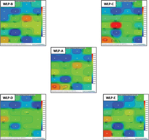
Figure 6. Isoconcentration map generated from discrete soil sample data collected at a known arsenic-contaminated site on the Island of Hawaii (after ERM, Citation2008). Random small-scale variability of arsenic concentrations in soil at the scale of a discrete sample are expressed in the map as isolated “hot spots” and “cold spots,” particularly within the transitional area (Zone B) that separates areas of consistently low (Zone A) and high (Zone C) arsenic concentrations. Red and green cells in inserts to the right of the map illustrate hypothetical distribution of discrete sample points above (red) and below (green) the target arsenic screening level within each zone.