
Figures & data
Figure 1. The Aosta Valley Region, in the NW Italian Alps.
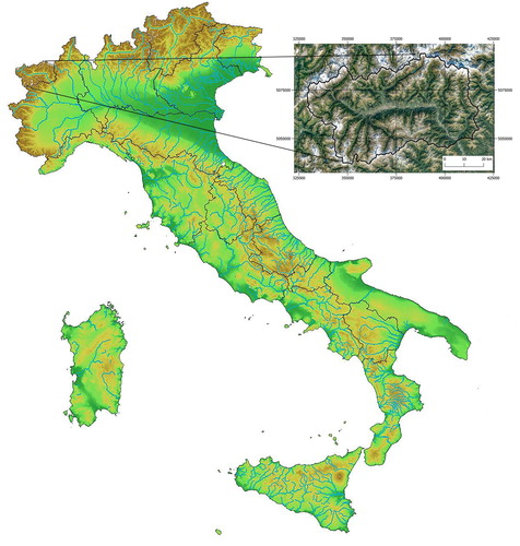
Figure 2. (a) Elevation map derived from the 10 m DEM of the Aosta Valley Region; (b) Mean Annual Precipitation (MAP); (c) slope angle; (d) Absolute Aspect; (e) Parent Material, reclassified from CitationBonetto et al. (2010); (f) vegetation/land cover maps, simplified from CitationAmedei et al. (2009).
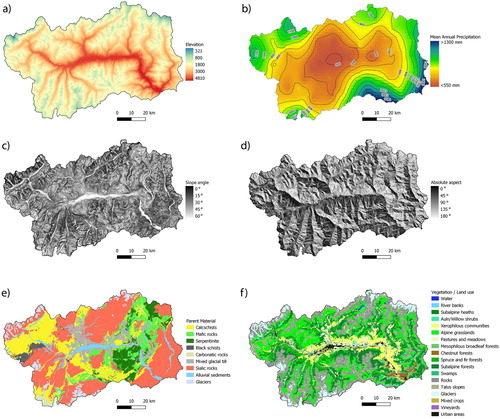
Table 1. Parent material classification based on the 1:100,000 scale geological map; landslide and slope deposits and unclassified sediments have been reclassified according to their lithological composition and then attributed to the other existing categories.
Table 2. Land use/vegetation classification used for the production of the soil map.
Table 3. Cartographic Units in the Aosta Valley soil map 1:100,000, and the most important environmental properties in which they can be found.
Figure 3. Examples of soil types belonging to the 16 CUs (). (a) CU1 – Albic Ortsteinic Podzol; (b) CU2 – Entic Ortsteinic Podzol; (c) CU3 – Umbric Entic Podzol; (d) CU4 – Protospodic Dystric Cambisol; (e) CU5 – Haplic Phaeozem; (f) CU6 – Calcic Kastanozem; (g) CU7 – Petric Calcisol; (h) CU8 – Calcaric Regosol; (i) CU9 – Cambic Umbrisol; (j) CU10 – Eutric Skeletic Cambisol; (k) CU11 – Hypocalcic Cambisol (Rhodic); (l) CU12 – Dystric Cambisol; (m) CU13 – Eutric Regosol; (n) CU14 – Turbic Regosol; (o) CU15 – Haplic Fluvisol (Arenic); (p) CU16 – Dystric Leptosol.
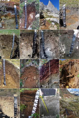
Table 4. Confusion matrix for the training data set, showing the number of profiles included in polygons attributed to different CUs in the produced soil map.