
Figures & data
Figure 1. Geographic setting of Gozo within the Maltese Islands (central Mediterranean Sea). Satellite images are derived from Google Earth (map data: SIO, NOAA, US Navy, NGA, GEBCO, Landsat/Copernicus). The map data of Gozo and Comino islands (upper right corner) are derived from CitationOpenStreetMap database (2022). Geographic coordinates are represented in the WGS84 reference system.
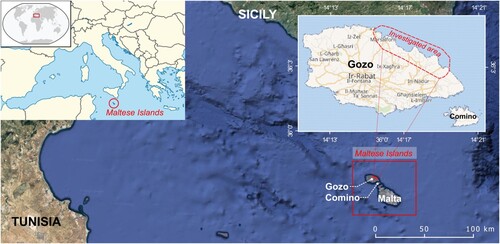
Figure 2. Physical setting of the study area (geographic coordinates are expressed in WGS84).
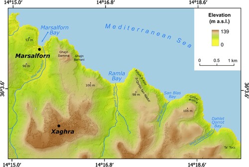
Figure 3. Coastal landscapes of the north-eastern sector of the Island of Gozo: (a) the densely inhabited Marsalforn Bay; (b) the gold-reddish sands of Ramla Bay; (c) coastal clay slopes east of Marsalforn Bay within the Għajn Barrani protected area; (d) traditional boat houses at Dahlet Qorrot Bay.
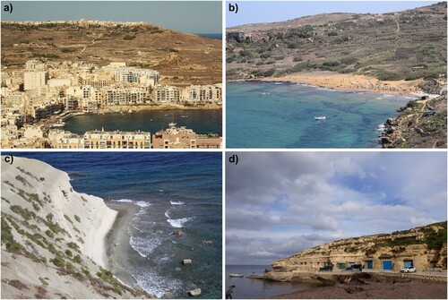
Table 1. Sea level values used in this study for the evaluation of potential coastal inundation and coastline retreat under different scenarios.
Table 2. Storm surge values referred to return periods of 10 and 100 years which were used in this study for the evaluation of potential coastal inundation and coastline retreat under different scenarios.
Table 3. Extent of the areas potentially inundated by sea level rise under the scenarios SSP1-2.6 and SSP5-8.5.
Figure 4. Percentage of area potentially inundated resulting from the analysis of the extent of the low-lying areas (a, c) and of the area within 5 m above sea level (b, d). Upper panels (green dots) refer to SSP1-2.6 scenarios while lower panels (blue dots) refer to SSP5-8.5 scenarios.
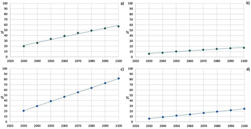
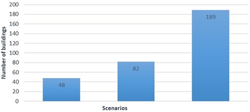
Figure 5. Numbers of buildings potentially inundated considering the SSP5-8.5 scenario for the year 2050 (first column), 2100 (second column) and with the contribution of storm surge with a return period of 100 years (third column).
Supplemental Material
Download Zip (63.7 MB)Data availability statement
The base map of the marine areas is a 5-m resolution Digital Terrain Model (DTM) resulting from the merge of bathymetric data acquired during different oceanographic surveys:
MEDCOR2009 carried out on board the R/V Urania of the CNR using the Kongsberg Simrad multibeam EM3002D and processed using CARIS HIPS & SIPS;
ERDF156 carried out by Malta Environment and Planning Authority (MEPA) on board the ISIS catamaran of the AquaBioTech Group using the SEA Company interferometric system SWATHplus-L.
Bathymetry from MEDCOR2009 is available for public consultation and downloadable at the resolution 1/16 * 1/16 arc minutes from the EMODnet Bathymetry Portal (https://portal.emodnet-bathymetry.eu/). The DTM of the Island of Gozo is 1 m-resolution and it is provided by the Malta Planning Authority. The data obtained in this study are available from the corresponding author [NS], upon reasonable request.