Figures & data
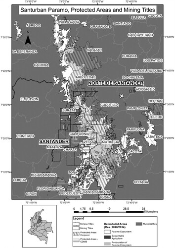
Figure 1. Map of the Santurbán páramo, protected areas and mining concessions.
Source: Emerson Buitrago, based on public information and the following sources: for the administrative political structure, see Instituto Geográfico Agustín Codazzi (IGAC) (2010); for the boundaries of Santurbán páramo, see MinAmbiente (Decree 2090, 2014); for polygons of protected areas, see Registro Único Nacional de Áreas Protegidas (RUNAP, 2020); and for the mining titles, see Sistema de Información Geográfica para la Planeación y el Ordenamiento Territorial Nacional (SIG-OT, 2017).