
Figures & data
Table 1. Classification of land-cover classes based on landscape vegetative strata
Figure 1. Map of 1992 North American breeding bird survey routes color-coded by species-richness estimates, with values divided into five groups at natural breaks.
Notes: Longitude and latitude coordinates identified in the map correspond to splitting points in the regression tree (see Figure ; longitude = −97.44, latitude = 35.98). Land and water base layers were generated using free spatial data from Natural Earth. Source: http://www.naturalearth.com/.
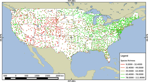
Figure 2. Scatter plots of species-richness estimates against latitude, longitude, mean elevation, standard deviation of elevation, land-cover diversity, and proportions of the four strata classes present within 5 km buffers around each BBS route.
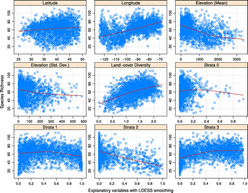
Table 2. Confidence intervals (95% on α=0.05) for coefficient estimates of listed variables, significance levels of the same, and the last three digits (all numbers began with 16) of model-wise AIC values for each of the multiple-regression models examined (10 models total)
Table 3. Tabular summary of regression-tree output depicting each node with the value of the splitting point, the number of data points on its right-hand (n), and their deviance and mean
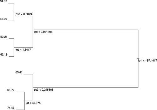
Figure 3. Plot of the regression tree generated using all geographic and land-cover variables together.
Notes: The left side of the split indicates that the conditional is true, and the right side that it is false. The vertical length of branches indicates the amount of deviance reduction. Variable abbreviations as follows: lon = longitude, lcd = land-cover diversity, ps3 = proportion of cells in strata-class 3, and lat = latitude.
Supplemental material