
Figures & data
Figure 1. Methodology of the study.
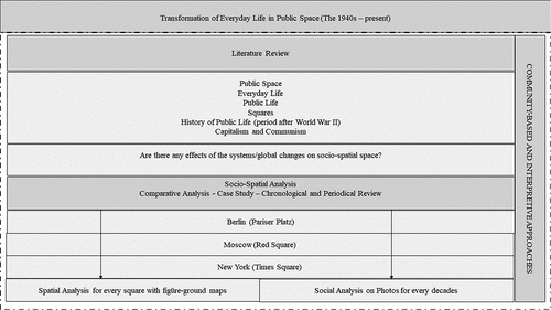
Figure 2. Location of the squares (a. Paris Square, b. Red Square, c. Times Square).[Footnote1]
![Figure 2. Location of the squares (a. Paris Square, b. Red Square, c. Times Square).[Footnote1]](/cms/asset/3226bd15-2944-47f9-b9a9-b9993943d19f/oass_a_2281063_f0002_oc.jpg)
Figure 3. The spatial change of Paris Square, Berlin (1940–2020).[2][Footnote3]
![Figure 3. The spatial change of Paris Square, Berlin (1940–2020).[2][Footnote3]](/cms/asset/6b8c3c51-5f3c-4e39-b3c4-e36950ecd85d/oass_a_2281063_f0003_oc.jpg)
Figure 4. The spatial change of Red Square, Moscow (1940–2023).[2][Footnote4]
![Figure 4. The spatial change of Red Square, Moscow (1940–2023).[2][Footnote4]](/cms/asset/b67a6045-e9f2-451a-b3f5-589ab5edf448/oass_a_2281063_f0004_oc.jpg)
Figure 5. The spatial change of Times Square, New York (1940–2020).[2][Footnote5][Footnote6][Footnote7]
![Figure 5. The spatial change of Times Square, New York (1940–2020).[2][Footnote5][Footnote6][Footnote7]](/cms/asset/5c5a2c8e-9635-491f-b9df-357b56c0f922/oass_a_2281063_f0005_oc.jpg)
![Figure 6. Change of social behaviour and Activities.[Footnote2] [Footnote8]](/cms/asset/c1e1a2f3-3acb-4721-a9e7-8929d8afad2b/oass_a_2281063_f0006a_b.gif)
Figure 6. (Continued).
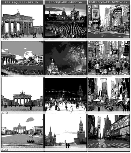
Table 1. Evaluation of socio-spatial breaking points