Figures & data
FIGURE 1. Map showing the study area and the four study lakes: Jeknajaure, Niak, Sjuodjijaure, and Seukokjaure. The line on the overview map indicates the birch forest limit. The lines on the small maps indicate the drainage areas for the lakes; shaded areas are glaciers
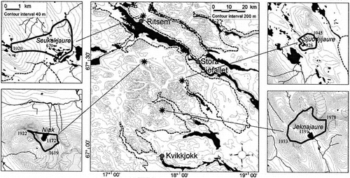
FIGURE 2. Pollen (a) and diatom diagrams (b) from Jeknajaure (1191 m a.s.l.) and diatom diagram from Niak (c) plotted against sediment depth. Black silhouettes represent percent and open silhouettes per mil occurrences. The first column shows calibrated ages; 0 corresponds to the coring date. Lines indicate statistically significant zones. Temperatures within parentheses are statistically significant July air temperature optima for the taxa. An optimum below the gradient in the training set is indicated by < and beyond the gradient by >; (-) indicates no statistically significant optimum. Only the most common taxa are shown
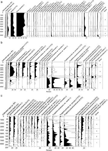
FIGURE 3. Pollen (a), chironomid (b), and diatom (c) diagram from Sjuodjijaure (826 m a.s.l.) plotted against sediment depth. Black silhouettes represent percent and open silhouettes per mil occurrences. The first column shows modeled, calibrated ages; 0 corresponds to the coring date. Lines indicate statistically significant zones. Temperatures within parentheses are statistically significant July air temperature optima for the taxa. An optimum below the gradient in the training set is indicated by < and beyond the gradient by >; (-) indicates no statistically significant optimum. Only the most common taxa are shown
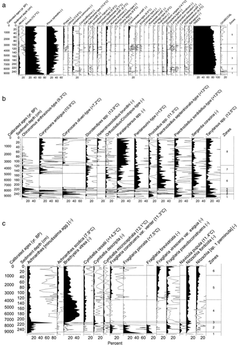
FIGURE 4. Pollen (a), chironomid (b), and diatom (c) diagrams from Seukokjaure (670 m a.s.l.) plotted against sediment depth. Black silhouettes represent percent and open silhouettes per mil occurrences. The first column shows calibrated ages; 0 corresponds to the coring date. Lines indicate statistically significant zones. Temperatures within parentheses are statistically significant July air temperature optima for the taxa. An optimum below the gradient in the training set is indicated by < and beyond the gradient by >; (-) indicates no statistically significant optimum. Only the most common taxa are shown
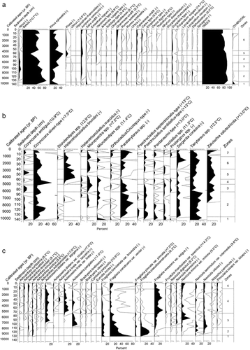
FIGURE 5. Sample scores from correspondence analysis (CA) of downcore diatom assemblages from Jeknajaure (JEKN), Niak, Sjuodjijaure (SJUO), and Seukokjaure (SEUK) compared to sample scores of diatom assemblages of surface sediments from the training-set lakes. The training-set lakes are classified as conifer forest, birch forest, or alpine lakes. Sample scores from downcore assemblages are based on 5-sample-running-mean values. ○ indicate the oldest sample in each lake and ▵ indicate the present. The CA shows both similar direction and magnitude of change in the diatom composition and suggests that the lakes have become more alpine through time
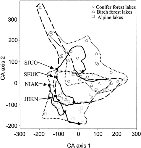
FIGURE 6. July air temperatures inferred from diatoms, chironomids, and pollen, and results of loss-on-ignition (LOI) measurements, in Holocene sediment cores from Jeknajaure (1191 m a.s.l.), Niak (1172 m a.s.l.), Sjuodjijaure (826 m a.s.l.), and Seukokjaure (670 m a.s.l.). Sample specific errors are for diatoms 0.9–1.2°C, chironomids 1.1–1.4°C, and pollen 1.4–1.7°C. Arrows show the present temperature at each lake. Open circles in the reconstructions indicate poor analogues and filled circles good analogues in the training set
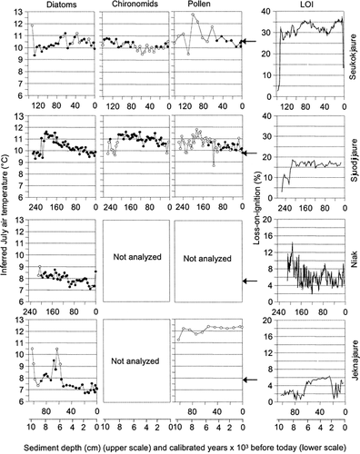
TABLE 1 Location and environmental characteristics of the study lakes
TABLE 2 Radiocarbon dates from Jeknajaure, Niak, Sjuodjijaure, and Seukokjaure. Calibrated ages are within 2σ