

ABSTRACT
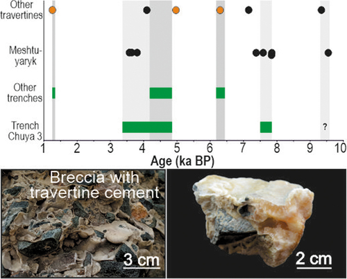
The Kurai Fault Zone (KFZ) is one of the most hazardous seismogenic structures in the Gorny Altai (Russia), which bounds the largest Kurai and Chuya intermontane basins from the north. Trenching studies, radiocarbon dating of colluvial wedge deposits, and 230Th-U dating of seismogenic travertine of the Meshtuyaryk field showed that the fault scarp in the northwestern part of the Chuya Depression was formed by earthquakes that occurred ca. 9.5, 7.7, 5.8, and 4.8–3.4 ka BP. The last two palaeoearthquakes are younger than 3.2 ka BP. The parameters of seismogenic ruptures, as well as the distances between coeval seismogenic travertines along the KFZ, yielded estimates of the Mw of the four oldest palaeoearthquakes as 6.8–7.6 and ESI 2007 shaking intensities of VIII–XI. The results of 230Th-U dating suggest that deposition of the Meshtuyaryk travertines was triggered by three strong palaeoearthquakes at ca. 9.5, 7.7, and 4.8–3.4 ka BP, which activated faults and caused a rapid rise along them of ambient-temperature bicarbonate groundwaters previously sealed in deep-seated limestone aquifers.
Graphic abstract
Highlights
Over the last 9.5 kyr, the Kurai Fault Zone has generated Mw = 6.8–7.6 earthquakes
Earthquake-related travertines formed at 9.5, 7.7, and 4.8–3.4 ka BP
Distance between coeval travertines was used to assess the earthquake magnitudes
Travertines were formed by ambient-T groundwater from deep-seated aquifers
Acknowledgments
The authors would like to thank the Editor Professor Robert Stern, Professor Andrea Brogi, and two anonymous reviewers. Their constructive comments and thoughtful suggestions are greatly appreciated.
Disclosure statement
No potential conflict of interest was reported by the author(s).
Supplementary material
Supplemental data for this article can be accessed online at https://doi.org/10.1080/00206814.2022.2145510.