Abstract
The Waka Nui-1 petroleum exploration well, about 90 km west of Northland, is the only offshore well north of Auckland and provides important lithologic and age control for interpretations of seismic reflection surveys in the petroleum-prospective Northland and Reinga basins. It is especially important because it intersects a nearly complete Cenozoic sequence and Mesozoic Murihiku Supergroup rocks, all of which may be part of the petroleum system in these basins. Correlation with seismic data is uncertain because neither sonic logs nor check shot data were acquired during drilling operations. This short communication documents the development of a two-way time– (TWT–) depth relationship derived by careful analysis of stacking velocities from nearby petroleum industry seismic data and logging-while-drilling logs from Waka Nui-1. Using this correlation, the age and lithology data from the well can be used to infer the age of unconformities and seismic sequences on seismic data in the Northland and Reinga basins. These interpretations provide control on the timing of structural events and the evolution of depositional processes in this region of extensive sedimentary accumulation and are vital for predicting the prospectivity of the basins.
Introduction
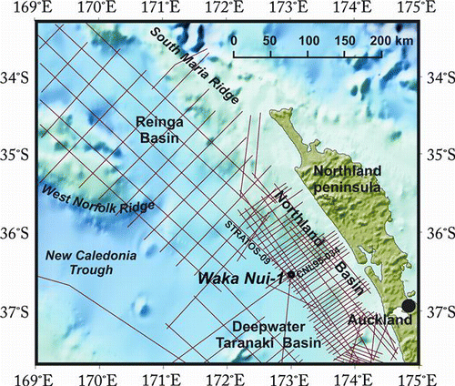
The Waka Nui-1 wildcat petroleum well lies about 90 km west of Kaipara Harbour in Northland and is the only offshore well north of Auckland (). Information from the well is critical for tying seismic data and constraining interpretations of the tectonic history and depositional environment in the entire offshore region northwest of New Zealand, including the petroleum-prospective Northland and Reinga basins. This is an area of approximately 140,000 km2 with sedimentary accumulations up to 8 km thick (e.g. Isaac et al. Citation1994; Uruski et al. Citation2008; Stagpoole et al. Citation2009). Because of the importance of the well for stratigraphic and structural control, most of the recent seismic surveys in the Reinga, Northland and deepwater Taranaki basins included lines that tie to Waka Nui-1.
Figure 1 Location map of Waka Nui-1 and some of the more modern seismic data (red lines) tied to the well.
Early seismic interpretations of the region (e.g. Isaac et al. Citation1994; Herzer Citation1995; Gage & Kurata Citation1996; Herzer et al. Citation1997) were tied to wells in the Taranaki Basin. Regional depth conversion for these interpretations (e.g. Herzer Citation1992; Isaac et al. Citation1994) used stacking velocities, derived during processing of seismic data, to determine sediment thickness. Waka Nui-1 should have provided robust stratigraphic and structural ties to seismic interpretations, significantly better than ties to wells several hundred kilometres away in northern Taranaki Basin. However, no velocity data are available from the well and therefore ties to seismic data from the region are uncertain because of the ambiguities in correlating units on seismic data with formations in the well. Indeed, some recent seismic interpretations in the Northland region still rely on a two-way time– (TWT–) depth relationship developed from check-shot data from northern Taranaki Basin wells (Klue Citation2008; Johnston Citation2009).
This short communication describes analysis of the data from the Waka Nui-1 well and proximal seismic data and proposes a TWT–depth relationship that can be used to extrapolate stratigraphic and structural data from the well to seismic data in the Northland and Reinga basins.
Well data
The Waka Nui-1 well was spudded on 30 April 1999 and was drilled in 1455 m of water (Milne & Quick Citation1999). The well reached a total depth of 3657 m bmsl (depth below mean sea level). No oil shows and only trace amounts of gas were recorded, so the well was plugged and abandoned on 25 June 1999. Down-hole lithology, stratigraphy and logging while drilling (LWD) were recorded (). No post-drilling wireline logs are documented in the well completion report (Milne & Quick Citation1999). Available well logs are natural gamma ray, resistivity, photo-electric effect, density and neutron porosity. Neither sonic logs nor check-shot data are recorded from Waka Nui-1.
Figure 2 Summary of Waka Nui-1 well data showing gamma ray (GR), resistivity (LWD), density (RHOB) and neutron porosity (TNPH) logs, lithology and stratigraphy (from Waka Nui-1 Well Sheet 1:10,000, version 3.06.2008, Enclosure 1 of Stagpoole et al. 2009).
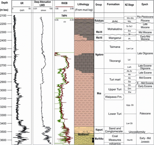
The well was drilled to test Cretaceous coal measures interpreted to be draped across the dip slope of a large tilted fault block. The upper part of the drilled sequence largely matched the well prognosis, but the predicted Cretaceous coal measures were not encountered. The coaly succession identified from the seismic data and encountered at the bottom of the hole are Middle Jurassic in age. It is almost certain that these rocks are part of the Murihiku Supergroup (Isaac et al. Citation1994; Campbell et al. Citation2003). The Jurassic coal measures are immediately overlain by Palaeogene transgressive strata (3440–3520 m bmsl), an unconformity representing about 100 million years (Uruski & Stagpoole Citation2004).
Two-way time–depth analysis
Integrating seismic interpretations with well data requires correlation of TWT on the seismic sections with depth in the well. This is done by converting the velocity and thickness of the strata in the well to TWT. The conversion is usually based on data from sonic logs that measure the seismic velocity of strata in the well, or from check-shot data that measure the travel time of seismic waves in strata adjacent to the well (Sheriff & Geldart Citation1995). Both sonic logs and check-shot data are typically acquired during drilling operations.
Because of the lack of velocity data in the Waka Nui-1 well, the TWT–depth analysis developed here is based on seismic stacking velocities from the CNL95-034 seismic line that passes directly over the well site, and from the more recent STRATOS-09 line that passes within about 2 km of the well site. Both are good quality seismic lines, recorded with hydrophone streamers > 6000 m long and a source array with > 40 litre airgun capacity. During processing of the data by a commercial seismic processing company, stacking velocities were determined at intervals between 2 and 5 km along each seismic line. Stacking velocities are usually derived from semblance analysis and are part of the seismic data package. Data from 12 velocity analysis locations close to the well (shown as crosses in Fig. 3) were converted to interval velocities using the Dix equation (Dix Citation1955). The interval velocities and TWT thickness were used to estimate interval thickness in metres, and these were summed to give depth below sea floor. The calculated depths were plotted as a function of TWT () and used to derive a single TWT–depth relationship for the well site.
Figure 3 TWT–depth relationship for the Waka Nui-1 well (grey line connecting blue dots). Crosses show the stacking velocity data derived during processing of the seismic data on nearby seismic lines and the red line shows the interval velocities calculated from seismic or TWT–depth function.
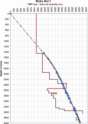
The TWT–depth relationship was compared to the density log from the well (). Minor adjustments were made to the gradient of the TWT–depth relationship to tie the depth of significant density variations on the density log (RHOB) log with strong seismic events on the CNL95-034 seismic line. The adjustments improved the correlation of the brightest seismic reflector on line CNL95-034 at 3300 ms TWT with a significant Early Eocene decrease in density about 2930 m bmsl, and other significant density variations on the log correlate well with seismic horizons on the line. With the minor gradient adjustments the TWT–depth curve still lies within the range of stacking velocity values (), particularly with data from the most recent STRATOS-09 line.
Figure 4 Seismic data from line CNL95-034 at the Waka Nui-1 well with overlays showing the density log (RHOB converted to TWT-left of well), a synthetic seismogram (overlaid on the well) and depths of formations (to the right of well).
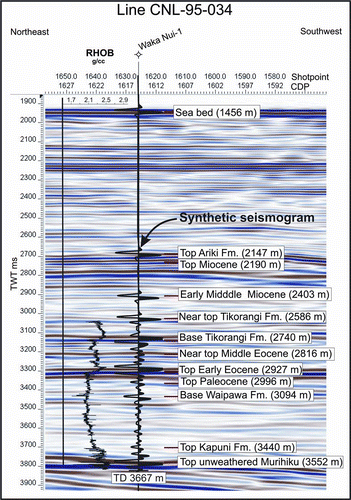
Interval velocities () were combined with the density log to create a synthetic seismogram using the synthetic generation tool in the SeisWare seismic interpretation package. The synthetic seismogram using a 30 Hz Ricker wavelet correlates well with the seismic data from line CLN95-034, reproducing the most significant seismic events at the well location () such as the significant Early Eocene event at 3300 ms TWT. Because the velocities used to create the synthetic seismogram are derived from the seismic data rather than a sonic log, the synthetic seismogram is only useful for identifying significant errors in the TWT–depth relationship.
Discussion
Interpreted interval velocities (, ) increase with depth to the top of a high velocity layer (c. 3200 m/s) at a depth of 2555 m bmsl, corresponding to the Oligocene and Late Eocene Tikorangi Formation limestone in the well. Below 2740 m bmsl (base of the limestone), velocities range from 2200 to 2700 m/s and increase to 4200 m/s in Murihiku Supergroup rocks at the bottom of the well.
Table 1 Depth, two-way time and interval velocity data derived for the Waka Nui-1 well site.
The interval velocities for geological formations were compared with velocities used by Herzer (Citation1992) to map the offshore Northland Basin and with those derived for coeval formations in the Taranaki Basin (Thrasher Citation1988; Stagpoole Citation1997). Both these interpretations show a general increase in interval velocities from the seabed to the base of the Tikorangi Formation, lower velocities in the Eocene and Palaeocene formations and increasing velocities in Cretaceous and older strata. In the Taranaki Basin, the marked velocity reversal in Eocene and Palaeocene formations has been attributed to fluid over-pressure in the sandstone and mudstone formations below the Tikorangi Limestone (Humphris & Ravens Citation2000). However, no significant overpressure intervals were recorded in the mud-weight log from Waka Nui-1, with recorded mud weights less than 11 ppg (pounds per gallon) throughout the drilling operations (Milne & Quick Citation1999). Lithology also contributes to the velocity contrast, with limestone generally having a higher seismic velocity than either sandstone or mudstone (Sheriff & Geldart Citation1995).
The interval velocities derived for Waka Nui-1 well below the Tikorangi Formation limestone are on average lower than those in Taranaki, but they are within the range of velocities reported for these rocks in Taranaki wells (2350–4600 m/s; Stagpoole Citation1997). Explanations for the relatively low interval velocities include less compaction due to less sedimentary overburden in Waka Nui-1 (in general about one kilometre thinner than in Taranaki) and/or regional lithology variations.
The TWT–depth relationship in this study is an advance on previous work, but there are still ambiguities in the tie between seismic data and the stratigraphy in the well. This correlation will be further improved and the regional controls on seismic velocities better understood when more wells are drilled in the region and velocity data are collected during drilling operations.
Conclusions
Ties of seismic reflection data with the Waka Nui-1 well are uncertain because of the lack of velocity data from the well. This short communication documents a method that uses well data and petroleum industry seismic reflection data to derive a TWT–depth relationship for the well site (). The resulting relationship, based on stacking velocities and LWD logs from the well, provides a good correlation between significant density contrasts in the well and strong seismic horizons on the seismic data and is similar to relationships derived from previous studies in Northland and Taranaki.
The relationship can help constrain interpretations of seismic reflection data in the Northland and Reinga basins. The age and lithology correlations with the Waka Nui-1 well will aid geological interpretations of the offshore region northwest of New Zealand.
Acknowledgements
The author thanks Chris Uruski, Ray Wood and two anonymous reviewers for reviewing this manuscript and providing helpful advice. Information on the SeisWare seismic interpretation package is available from http://www.seisware.com.
Related Research Data
References
- Campbell , HJ , Mortimer , N and Turnbull , IM . 2003 . Murihiku Supergroup, New Zealand: redefined . Journal of the Royal Society of New Zealand , 33 ( 1 ) : 85 – 95 .
- Dix , CH . 1955 . Seismic velocities from surface measurements: Geophysics , 20 : 68 – 86 .
- Gage M , Kurata Y 1996 . Is there a mid-Cretaceous passive margin sequence beneath the Northland Basin, New Zealand . In 1996 New Zealand Petroleum Conference Proceedings, New Zealand Crown Minerals, Ministry of Commerce, Wellington . Pp. 1 – 11 .
- Herzer RH 1992 . Subsurface maps of the Northland Basin, New Zealand 1:500 000 . New Zealand Geological Survey report G. 164 .
- Herzer , RH . 1995 . Seismic stratigraphy of a buried volcanic arc, Northland, New Zealand and implications for Neogene subduction . Marine and Petroleum Geology , 12 ( 5 ) : 511 – 531 .
- Herzer RH , Chaproniere GCH , Edwards AR , Hollis CJ , Pelletier B , Raine JI , Scott GH , Stagpoole VM , Strong CP , Wilson GJ and others 1997 . Seismic stratigraphy and structural history of the Reinga Basin and its margins, southern Norfolk Ridge system . New Zealand Journal of Geology and Geophysics 40 ( 4 ): 425 – 451 .
- Humphris D , Ravens JM 2000 . Braver and better velocities in the Taranaki Basin, New Zealand . In 2000 New Zealand Petroleum Conference Proceedings, New Zealand Crown Minerals, Ministry of Economic Development, Wellington . Pp. 304 – 307 .
- Isaac MJ , Herzer RH , Brook FJ , Hayward BW 1994 . Cretaceous and Cenozoic sedimentary basins of Northland, New Zealand. Lower Hutt, Institute of Geological & Nuclear Sciences . 230 p .
- Johnston SW 2009 . Seismic stratigraphy of the Northland Basin, New Zealand: Late Oligocene to Recent . Unpublished MSc thesis, University of Auckland. 146 p .
- Klue B 2008 . An integrated geophysical investigation of the southern Northland Basin, New Zealand . Unpublished MSc thesis, University of Auckland .
- Milne A , Quick R 1999 . Waka Nui-1 Well Completion Report. PEP 38602. Ministry of Economic Development unpublished petroleum report . 2436 PR2436. 922 p .
- Sheriff RE , Geldart LP 1995 . Exploration Seismology, second ed . Cambridge University Press, Cambridge. 592 p .
- Stagpoole VM 1997 . A geophysical study of the northern Taranaki Basin, New Zealand . Unpublished PhD thesis, Victoria University of Wellington .
- Stagpoole VM , Reid E , Browne GH , Bland KJ , Ilg BR , Griffin AG , Herzer RH , Uruski CI 2009 . Petroleum prospectivity of the Reinga Basin, New Zealand . GNS Science Consultancy Report. 2009/251. 2 logs, 105 p .
- Thrasher , GP . 1988 . The interpretation of seismic reflection data from the Western Platform region of Taranaki Basin . Energy Exploration & Exploitation , 6 ( 2 ) : 136 – 150 .
- Uruski CI , Stagpoole VM 2004 . Wakanui-1, independent well summary. Institute of Geological & Nuclear Sciences client report . 2004/06. 1 enclosure, 21 p .
- Uruski CI , Browne GH , Stagpoole VM , Herzer RH , Bland KJ , Griffin AG , Sykes R , Roncaglia L , Schioler P , Funnell RH and others 2008 . Petroleum prospectivity of the Northland Basin, New Zealand . GNS Science Consultancy Report. 2008/190 . 3 enclosures, 89 p .