Abstract
Multibeam bathymetric surveys east of the South Island of New Zealand yield images of submarine volcanoes and pockmarks west of Urry Knolls on the Chatham Rise, and evidence of submarine erosion on the southern margin of the Chatham Rise. Among numerous volcanic cones, diameters of the largest reach c. 2000 m, and some stand as high as 400 m above the surrounding seafloor. The tops of most of the volcanic cones are flat, with hints of craters, and some with asymmetric shapes may show flank collapses. There are hints of both northeast–southwest and northwest–southeast alignments of volcanoes, but no associated faulting is apparent. Near and to the west of these volcanoes, huge pockmarks, some more than c. 1 km in diameter, disrupt bottom topography. Pockmarks in this region seem to be confined to seafloor shallower than c. 1200 m, but we see evidence of deeper pockmarks at water depths of up to 2100 m on profiles crossing the Bounty Trough. The pockmark field on the Chatham Rise seems to be bounded on the south by a trough at almost 1200 m depth; like others, we assume that contour currents have eroded the margin and created the trough.
Introduction
Crust much thicker than that beneath deep ocean basins underlies two regions with relatively shallow water (<1000 m) east of the South Island of New Zealand: the Chatham Rise and Campbell Plateau (e.g. Davy & Wood Citation1994; Grobys et al. Citation2008, Citation2009) (). When these crustal fragments rifted away from Antarctica in the late Cretaceous, they also separated from one another along a rift that never grew wide (Carter & Carter Citation1987; Carter et al. Citation1994). Between the Chatham Rise and Campbell Plateau, sea floor deepens in the Bounty Trough, and Grobys et al. (Citation2007) interpreted their marine geophysical investigations to reveal evidence of such rifting, also in the Cretaceous. As much as 1–2 km of sediment, derived from erosion of the South Island, has subsequently accumulated in the Bounty Trough (e.g. Uenzelmann-Neben et al. Citation2009). According to this interpretation, the Chatham Rise, Bounty Trough and Campbell Plateau are all essentially tectonically dead. However, as others have shown and we document further below, the seafloor seems to be active in a number of ways, with volcanism, subsurface gas flow and submarine erosion all altering the bathymetry.
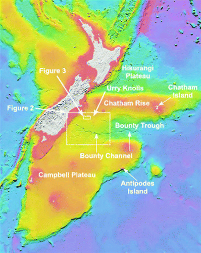
Figure 1 Regional bathymetric chart of the region surrounding New Zealand showing the locations of the multibeam surveys discussed in the text. Boxes show the areas in Figs. 2, 3. This chart (CANZ Citation2008) was cropped from one provided by New Zealand's National Institute of Water & Atmospheric Research (NIWA). Content, datasets and imagery are provided by NIWA. Used with permission of NIWA.
On recent cruises to deploy and recover ocean-bottom seismographs deployed around New Zealand (Collins et al. Citation2009, Collins et al. Citation2010), we carried out multibeam surveys of the bathymetry in regions of special interest and in those suggested to us by geologists from New Zealand. These surveys focused on an area with different, largely unrelated features: volcanic topography near the Urry Knolls, pockmarked bathymetry just west of the region of widespread volcanism, and a sharp boundary to the Chatham Rise that seems to be the result of sub-bottom erosion (). Our purpose in this paper is to make these bathymetric data available to others and to offer simple interpretations of them. As these studies address different topics and stand alone, we present them separately, and also include single-line multibeam swaths crossing the region ().
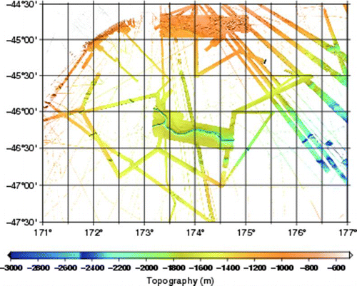
Figure 2 Map showing all multibeam profiles, including those in Figs. 3–6, 8 and 10, and others gathered in previous cruises.
Volcanism
Although Cenozoic volcanism is widespread in and around New Zealand, such volcanism seems to be concentrated either in large volcanic centres such as those on the Banks Peninsula (e.g. Hoernle et al. Citation2006; Timm et al. Citation2009) or in isolated small sites such as Antipodes Island (Cullen Citation1969) or on Chatham Island (Hoernle et al. Citation2006). Isolated single-channel (Herzer et al. Citation1989) and multibeam (Timm et al. Citation2010) coverage reveals other volcanism, but the sparse bathymetric coverage of the region surrounding New Zealand allows for the possibility of more extensive volcanism. We present evidence below of a field of volcanoes near the Urry Knolls that is unlike any previously mapped in New Zealand and its surroundings.
Pockmarks
In regions of the seafloor where natural gas has apparently escaped, the bathymetry commonly shows pits or holes into which surface sediment has collapsed so that the depressions resemble pockmarks on scarred facial tissue (e.g. King & MacLean Citation1970; Hovland Citation1981; Hovland & Judd Citation1988; Judd & Hovland Citation2007). Such pockmarks have now been found in many tens of regions globally, but largely in regions of known natural gas reserves (e.g. Judd & Hovland Citation2007; Pilcher & Argent Citation2007). Recently, Davy et al. (Citation2010) recognised pockmarked seafloor topography near the Urry Knolls on Chatham Rise (, ) from the similarity of their topographic signatures on a few multibeam swaths and high-resolution sub-bottom profiles to pockmarks recognised elsewhere. These pockmarks raise the questions of whether they are isolated features or widespread, and hence whether they might indicate extensive gas reserves in New Zealand waters. We show below that indeed pockmarks are widespread.
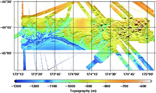
Figure 3 Multibeam bathymetry of a portion of the Chatham Rise showing pockmarked and volcanic terrain. These data were collected largely during the MOANA deployment (cruise TN229) and recovery cruises (cruise RR1002), with some lines from other historical cruises.
Deep submarine erosion on the Chatham Rise
Davy et al. (Citation2010) noted that the pockmarks on the Chatham Rise seem to be confined to seafloor shallower than c. 1200 m, where the south side of the Rise is bounded by a steep slope. Such a steep slope could result from strong contour currents but, as we discuss below, physical oceanographic measurements do not offer convincing evidence of strong present-day currents. We show that west of where Davy et al. (Citation2010) noted a steep slope, a trough with a steep slope on its north side closely follows the c. 1200 m contour and seems to result from erosion by a contour current, which we presume to flow eastwards.
Multibeam methods
The bulk of the multibeam data shown here were acquired with Kongsberg Simrad EM 300 (Cruise TN229, January–February 2009) and EM 122 (Cruise RR1002, January–February 2010) multibeam echo-sounding systems. Sounding velocities were computed from daily (or more frequent) expendable bathythermograph (XBT) profiles. The data shown here have not been corrected for tides. Some single-swath profiles shown in were acquired on historical cruises and were retrieved from the US National Geophysical Data Center (NGDC).
Submarine volcanoes near the Urry Knolls
From scattered dredge hauls, single-channel seismic reflection profiling, and bathymetry from wide-beam echo-sounding, Herzer et al. (Citation1989) showed evidence of relatively young volcanism on the Chatham Rise over the Urry Knolls (). This region lies hundreds of kilometres east of the volcanism on the North Island of New Zealand, which is associated with ongoing subduction of the Pacific plate, but lies within the Pacific plate itself. Its occurrence might therefore have been somewhat surprising if widespread Late Cenozoic volcanism had not occurred elsewhere in New Zealand and on surrounding islands (e.g. Hoernle et al. Citation2006; Timm et al. Citation2010).
Herzer et al. (Citation1989) found that samples from these submarine volcanoes were too altered to allow them to be dated, but they suspected that the volcanism was late Cenozoic in age. Basalts from the east coast of the South Island yield ages of 16–10 Ma near Dunedin and 12–6 Ma from the Banks Peninsula (Hoernle et al. Citation2006; Timm et al. Citation2009, Timm et al. Citation2010). Between these locations, Matthews & Curtis (Citation1966) measured 2.5±0.7 Ma from basalt near Timaru. Wood & Davy (Citation1994) reported late Cenozoic volcanism on the Hikurangi Plateau north of the Chatham Rise, and Hoernle et al. (2006) also reported ages near 6–7 Ma from Chatham Island. Cullen (Citation1969) gave two K–Ar ages of 0.25±0.2 Ma and 0.50±0.4 Ma from Antipodes Island. With less evidence of volcanism, Adams (Citation1981) inferred an eastwards progression of volcanism, but these dates reveal no obvious progression across the region. Subsequent detailed analysis by Timm et al. (Citation2010) has shown widespread volcanism across the Chatham Rise and Campbell Plateau with ages ranging from c. 65 Ma to<1 Ma, but with no obvious progression across the region or systematic temporal variations in composition with age. Consistent with these observations, Uenzelmann-Neben et al. (Citation2009, p. 149) inferred that deformation of the sedimentary sequence in the Bounty Trough to the east-southeast of the Urry Knolls is related to Miocene and subsequent magmatic activity. Despite the evidence of Late Cenozoic volcanism on the Chatham Rise and Campbell Plateau, active volcanism does not occur today on or even near the South Island.
We surveyed an area near Urry Knolls with a multibeam bathymetric system, and indeed a field of volcanoes is clear (Figs. ). Between approximately 44°41′S and 44°58′S and between 174°30′E and 175°E, volcanic cones abound. Some stand less than 100 m above the seafloor and are less than 300 m in diameter. The height of the tallest, however, exceeds 400 m; typical radii for tall cones are c. 1000 m (). They are spaced 5–10 km apart, with numerous smaller cones between them. Between clusters of cones are expanses with little topography. Note the nearly flat topography punctuated by only small cone-like structures, some apparently with moats around them, in the northwest part of the region (between 44°41′S and 44°45′S and 174°31′E and 174°41′E) and in the southeast part (between 44°48′S and 44°52′S and 174°46′E and 174°56′E) in , .
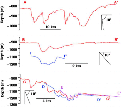
Figure 4 Shaded relief and bathymetric chart of the volcanic field near Urry Knolls. Cross-sections along the profiles A–A′ and B–B′ are shown in Fig. 7. Specific bathymetric features discussed in the text are labelled with lower case letters.
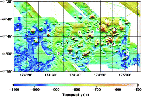
Figure 5 Plan view of volcanic cones located in the northeast of our surveyed area. Note the apparent flank collapse features on at least three of the cones. Volcanic features discussed in the text are labelled with lower case letters.
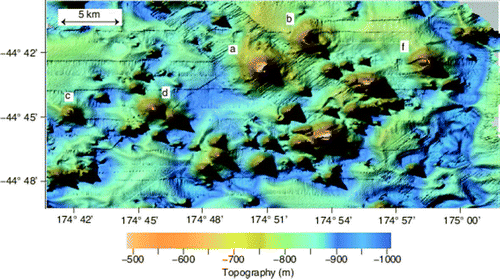
Figure 6 Oblique view, looking north, at a vertically exaggerated (×6) relief map of the volcanic field near Urry Knolls. Volcanic features discussed in the text are labelled with lower case letters.
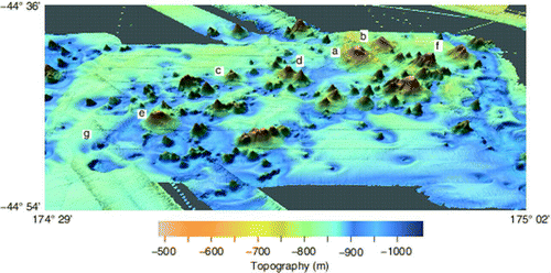
Figure 7 Profiles across volcanoes near Urry Knolls. Profile locations are shown in Fig. 4.
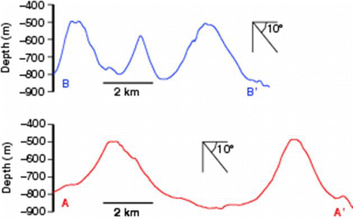
Most cones show radial symmetry, but some include an asymmetry easily interpreted as a result of major eruptions with failures of one side, or flank collapses. For instance, a tall cone near ‘a’ (Figs. ) seems to be missing its eastern flank, as if an eruption took that part away (similar to that which occurred in the 1980 Mount St Helens eruption in the western US). Another to its northeast (‘b’, Figs. ) seems to show most of a crater, but the rough topography just east of the crater raises the possibility that it might be debris lost from its eastern flank. Some tall cones seem to have craters at their tops (e.g. ‘c’, Figs. ). In some we might be seeing resurgent domes within the craters, such as at ‘c’ and ‘f’ (Figs. ). Surrounding some small cones are circular moats (e.g. ‘g’, , ). In some cases large depressions with steep sides hint of collapsed calderas (e.g. ‘h’, Figs. ), although the possibility exists that other processes have formed such crater-like depressions.
There seems to be a set of linear trends in the topography with east-northeast and west-northwest orientations (Figs. ). Cones line up with these orientations, but these patterns are subtle.
As noted above, Timm et al. (Citation2010) dated many seamounts on the Chatham Rise and Campbell Plateau. Using 40Ar/39Ar, they obtained a date of 14.45±0.22 Ma for one seamount () at the southeast end of profile A–A’ (). They also reported a date of 2.6±0.6 Ma from a nearby seamount (Timm et al. Citation2010; ).
Our survey documents the presence of but not the processes responsible for the Urry Knolls volcanic field. The petrology and alkaline content of both surrounding volcanic rock and a few samples from the field that we surveyed suggest that small degrees of melting occurred at relatively large depths within the lower lithosphere (e.g. Finn et al. Citation2005; Hoernle et al. Citation2006; Timm et al. Citation2009, Citation2010) and/or just beneath it. Hoernle et al. (Citation2006) and Timm et al. (Citation2009, Citation2010) associated volcanism near New Zealand with the removal of mantle lithosphere and partial melting of some of it. In support of this view, Hoke et al. (Citation2000) reported 3He/4He ratios consistent with upper mantle sources, but not enrichment associated with hotspots or plumes from the deep mantle. The occurrence of volcanism 200–300 km from the most intense deformation along the Alpine Fault and its continuation into the Marlborough fault zone might indicate ongoing deformation spread over a much wider zone than seems to be seismically active.
Mega-pockmarks on the Chatham Rise
Brief summary of pockmark characteristics
Since King & MacLean (Citation1970) apparently first recognised pockmarks on the seafloor, studies in a variety of settings have shown a spectrum of associated submarine topography. Pockmarks tend to be cone-shaped, at least when young, with walls sloping with constant dips of as much as 10° down to the centres, where floors are commonly flat (e.g. Uchupi et al. Citation1996; Pilcher & Argent Citation2007). Older pockmarks seem to have flatter bottoms (e.g. Paull et al. Citation2002), and Hovland (Citation1981) described some as ‘dish-shaped.’ The majority of those reported in the literature seem to be circular in planform, but asymmetrical pockmarks are common (e.g. Hovland Citation1982; Sultan et al. Citation2010), and connections of them can create a variety of topographic forms, as bathymetric charts of Pilcher & Argent (Citation2007) and Sultan et al. (Citation2010) illustrate well.
Most associate centres of pockmarks with loci of escaped or escaping gas or liquids (e.g. King & MacLean Citation1970; Hovland Citation1981, Citation1982; Hovland & Somerville Citation1985; Solheim & Elverhøi Citation1993; Uchupi et al. Citation1996; Loncke et al. Citation2004; Hustoft et al. Citation2009; Sultan et al. Citation2010). Many such pockmarks seem to be inactive, but rising gas above some of them supports the deduction that they form when gas escapes (e.g. Hovland et al. Citation1984; Hovland & Somerville Citation1985; Hovland & Judd Citation1988; Loncke et al. Citation2004). Some believe that they form in short periods, perhaps episodically (Hustoft et al. Citation2009) or even catastrophically (Hovland et al. Citation2005). Many pockmarks are underlain by bottom-simulating reflectors (BSR) (Hovland et al. Citation2005; Judd & Hovland Citation2007), which are attributed to low-density, low-speed, gas-rich layers trapped below impermeable hydrate caps. Where mapped in detail, such reflectors have been disrupted beneath the pockmarks, again consistent with a role for escaped gases (e.g. Judd & Hovland Citation2007; Hustoft et al. Citation2009). Although some pockmarks are aligned along faults where liquids and gases can escape more quickly than beneath laterally homogeneous layers (e.g. Dimitrov & Woodside Citation2003; Loncke et al. Citation2004; Judd & Hovland Citation2007), by no means are all associated with obvious faults.
Lateral dimensions of pockmarks range from tens of metres to several kilometres (e.g. Loncke et al. Citation2004; Pilcher & Argent Citation2007; Davy et al. Citation2010). Hovland & Judd (Citation1988, p. 116) stated that there is no dependence of pockmark size on water depths. Pilcher & Argent (Citation2007), however, show from a compilation of 57 sets of pockmarks that depths below the surrounding terrain (relief) are commonly roughly one-tenth of pockmark diameter. Although they plotted depths versus diameter on a log-log plot, for which there is much scatter, this scaling works quite well over four orders of magnitude in both dimensions.
Pockmarks on the Chatham Rise
On the south side of the Chatham Rise, west of the Urry Knolls and south of the Mernoo Bank, where depths of seafloor range from c. 750 m to 1400 m, we traversed disrupted seafloor with a wide range of dimensions, from as small as a few hundred metres to several kilometres in diameter, that resemble pockmarks (, ). Walls of pockmarks are quite steep, up to 10–12°, suggesting that they are young. Conical shapes are common but by no means ubiquitous (, ). Some small cones seem to be quite symmetrical, but most are clearly asymmetrical. Some groups seem to define alignments, but no consistent alignment stands out.
Figure 8 Close-up view of multibeam bathymetry in Fig. 3 showing pockmarked terrain and the locations of the profiles shown in Fig. 9. Pockmark features discussed in the text are labelled ‘h’ and ‘g’.
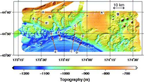
Figure 9 Profiles across selected pockmarks showing slopes, shapes of bottoms, and both symmetry for some and asymmetry for others. Profile locations are shown in Fig. 8.
In the eastern part of the mapped area (, ), not only do pockmarks seem to be present, but so also is the volcanic terrain described above. Volcanism overlaps part of the region with pockmarks, but not all of it.
The largest pockmarks that we mapped are among the largest that we have seen reported in the literature, although smaller than some of those described by Davy et al. (Citation2010) near this region or by Loncke et al. (Citation2004) from the Nile Delta. For example, the diameter of a pockmark along profile F–F′ () is c. 2 km. If the large feature at site ‘g’ (), apparently with two volcanoes in it, is a pockmark, its diameter is >5 km. A series of others near site ‘h’ () have diameters of c. 3 km. Pilcher & Argent (Citation2007) reported the diameter of the largest in their compilation to be 1300 m, but they seemed to have been unaware of the work of Loncke et al. (Citation2004) showing larger pockmarks. Pilcher & Argent (Citation2007) did note that Cole et al. (Citation2000) reported larger pockmarks of up to 4000 m in diameter, which had formed in Palaeogene time and were subsequently buried. Pilcher & Argent (Citation2007) also emphasised, however, that these large pockmarks seem to have formed by a coalescence of smaller pockmarks. The multiple scarps of some, like those crossed by line A–A′ () near 173°37′E, may imply such coalescence; simpler pockmarks such as that crossed by line B–B′ may have formed as single features in single events. (Michaud et al. (Citation2005) reported large crater-like features suggesting collapse of the seafloor on the Carnegie Ridge west of Ecuador, but they inferred that these features are not pockmarks such as those described above or shown in , , however.) None of those reported in the published literature that we are aware of, or that we found, seem to be as large as those discussed by Davy et al. (Citation2010), who show some pockmarks exceeding 10 km in diameter from the region east of our study area, but at shallower depths.
There is a tendency for the western sides of pockmarks in , to be steeper than the eastern sides, which gives the pattern an asymmetry. Hovland (Citation1982) noted a similarly consistent asymmetry (albeit in smaller pockmarks) off the west coast of Norway. We also observe many pockmarks that are not circular at all, such as those between 44°48′S and 44°50′S and between 174°35′E and 174°55′E. Similarly, Pilcher & Argent (Citation2007) showed troughs that might have formed by a coalescence of pockmarks where the regional topography slopes down the continental shelf. An area of linear or slightly curved pockmarks in is also found where the seabed slopes, in this case towards the south.
Although the pockmarks that we mapped do not show features that have not been reported elsewhere, they do seem to be atypically large examples, comparable to those found by Pilcher & Argent (Citation2007). Examples of profiles across them are depicted in . Slopes as great as 10° characterise many of the pockmarks, but not all.
Possible pockmarks in the Bounty Tough
Multibeam swath bathymetry profiles from the Bounty Trough collected by us and by others show what appear to be pockmarks in water depths of up to 2100 m (, ). The walls of some of these features have slopes of c. 20°, steeper than the pockmarks that we imaged on the Chatham Rise. Pockmarks from similar depths but of smaller diameter have been reported from the Mediterranean (Dimitrov & Woodside Citation2003).
Figure 10 Multibeam data from the Bounty Trough acquired during cruises TN229, RR1002 and earlier cruises. The locations of the profiles shown in Fig. 11 are indicated by the red lines.
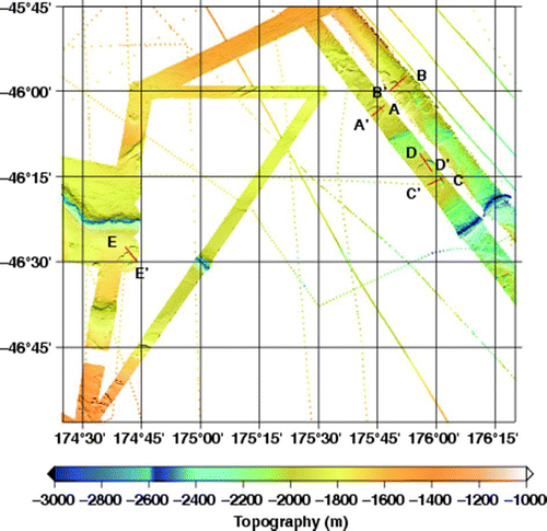
Figure 11 Profiles across selected possible pockmarks in the Bounty Trough. Locations of profiles are shown in Fig. 10.
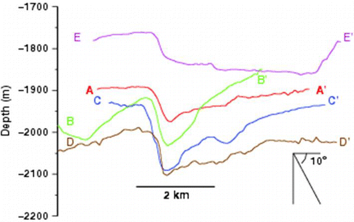
Assuming that these deep pockmarks were formed by the release of gas hydrates, these depths pose a potential problem. Because the stability field of gas hydrates deepens as pressure increases, stable gas hydrates in deep water should lie deeper beneath the seafloor than those at shallow depths, and therefore should be more immune to changes in pressure and temperature. Davy et al. (Citation2010) argued that the pockmarks at depths of 800–1200 m and near the Urry Knolls formed by the loss of gas in peak glacial times because of depressurisation during low sea level and/or during periods when bottom waters may have been warmer by 1 °C. At depths of up to 2100 m, the effect of sea-level change should be less important than at 1200 m, and bottom water changes are likely to have been smaller than at 1200 m. These deeper pockmarks need not have formed at the same time as those shallower than 1200 m, however. Thus, the explanation offered by Davy et al. (Citation2010) may not apply to the deeper pockmarks; perhaps the deeper pockmarks are much older than the shallower pockmarks.
Summary and discussion of mega-pockmarks
Pockmarked topography characterises the southern margin of the Chatham Rise west of the Urry Knolls. Such topography presumably reflects the exhalation of natural gas and collapse of the overlying sediment into depressions created by this loss. Although Davy et al. (Citation2010) argued that such gas loss for pockmarks in water depths>800 m likely occurred during peak stages of glacial periods, when sea level was lower by c. 100 m, we are not aware of evidence that gas is not escaping at present or that the pockmarks are not actively forming.
Hovland & Somerville (Citation1985) noted two possible sources of gas. Some is biochemically produced in place from the decay of organic material and, until exhalation, remained where they were produced. In addition (or alternatively), warming of organic material not only can accelerate decay and formation of gas, but also facilitate its migration and concentration at shallow depths. Pockmarks with this thermogenic origin seem to be much more common than those of purely biogenic origin (Hovland & Somerville Citation1985; Solheim & Elverhøi Citation1993; Uchupi et al. Citation1996; Cole et al. Citation2000; Maestro et al. Citation2002). The close proximity of many of the pockmarks to the volcanic terrain of Urry Knolls (, ) makes a thermogenic source more likely.
We refrain from speculating on what the pockmarks mean for potential gas reserves in this part of the Chatham Rise or any of the regions surrounding New Zealand, but obviously the large dimensions of the pockmarks might mean that much gas has already been lost and/or that much gas remains to be found.
Deep submarine erosion on the Chatham Rise
The multibeam bathymetric charts in , reveal a steep southward slope and a slightly deepened region that approximately follows the 1200 m contour. Davy et al. (Citation2010) had recognised an erosive slope further east, but did not report a trough. Like them, we presume this steep slope and trough to be a region of intense contour currents that have either eroded sediment or prevented its deposition.
The deepest region on the multibeam bathymetric chart in , is defined by a narrow zone 3–4 km wide and trending east-southeast from the southern edge of the chart near 44.95°S, 174.10°E to 44.85°S, 173.75°E. Although disrupted by pockmarks, it continues west and then west-southwest to form an arcuate trough that becomes shallower to the west and reaches the edge of the chart near 44.95°S, 173.30°E. Although this trough does not follow contours precisely, clear disruptions by pockmarks make it likely that gas exhalation has disrupted it. Perhaps more importantly, the notably shallower depths north of this trough (1000 m and shallower) compared to those south of the trough (>1100 m) give the impression that the trough and steep slope to its north have been cut into the southern edge of the Chatham Rise at almost a constant depth near 1200 m, as Davy et al. (Citation2010) noted. Following their interpretation, we infer that deep-sea currents that follow contours (contour currents) have carved this trough. If this interpretation is correct, it allows for the trough to be actively forming. In contrast, Davy et al. (Citation2010) inferred the steep slope to have formed principally by strong currents during glacial times. In the latter case, present-day ocean currents might be irrelevant to the formation of the trough.
Unsurprisingly, the Chatham Rise profoundly affects ocean circulation. Chiswell (Citation2002) associated the location of the Subtropical Front, which separates Subtropical Water on the equatorial side to the north from Subantarctic Water, with the Chatham Rise. The Subtropical Front marks a sharp contrast in temperature, salinity and density (Chiswell Citation2002; Sutton Citation2001). With the Subtropical Front interrupted by the islands of New Zealand, however, eastwards geostrophic flow seems to be supplied by the Southland Current, which flows northwards along the east side of the South Island and carries as much as 9.3 Sv (1 Sverdrup = 1×10⁶ m3 s−1) of water (Sutton Citation2003). This work focused on currents shallower than 500–600 m however, and concentrated on the upper 300 m. For example, Morris et al. (Citation2001) showed 5 Sv of eastwards flow in the upper 300 m along the southern Chatham Rise. Thus, the Southland Current and geostrophic flow associated with the Subtropical Front might be irrelevant to the seafloor topographic features at depths near 1000 m, which we discuss here.
The pattern of flow implied by the Southland Current and geostrophic flow associated with the Subtropical Front is essentially opposite to that described by Carter & Wilkin (Citation1999), who exploited oceanographic data from sections in the New Zealand area and a numerical ocean circulation model to infer a pattern of sub-bottom flow. For the southern side of the Chatham Rise, they reported westwards flow along the bottom at depths <2500 m and essentially along contours. As well as we can resolve from their , Carter & Wilkin (Citation1999) showed westwards flow in the depth range of c. 1000 m but not with high speed (c. 1 cm s−1). Their map, however, does not reach far enough to the west for us to be confident that the westwards flow applies to the region in , . The focus on depths greater than 2500 m in the study by Carter & Wilkin (Citation1999), the dependence on model simulations to fill in regions where data are sparse, and the low rates of flow make us dubious of the significance of this flow for the features that we discuss.
McCave & Carter (Citation1997) and McCave et al. (Citation2008) noted that Antarctic Intermediate Water, which forms by cold water sinking at the Antarctic Polar Front, moves northwards in the depth range of c. 600–1450 m. Elderfield et al. (Citation2010) illustrated its distribution on a north–south profile through the Chatham Rise. Since these studies focused on the region further north, their discussion provides little information about the circulation of the Antarctic Intermediate Water south of the Chatham Rise.
The most important data constraining flow near 1000 m may come from floats, apparently from the Argo program (e.g. http://www.argo.ucsd.edu/About_Argo.html). In their , Morris et al. (Citation2001) showed eastwards flow along the 1000 m contour. They based this largely on trajectories of floats at a depth of c. 900 m. Palaeoceanographic studies replicated a figure similar to theirs, with an arrow showing eastwards flow approximately along the 1000 m contour (e.g. Crundwell et al. Citation2008; McCave et al. Citation2008), but those papers do not discuss the arrow.
We deduce that sufficiently rapid eastwards flow along the contours near 1000–1200 m during the past few hundred thousand years has created this trough by preventing sedimentation and by eroding older sediment. When that erosion was most intense might have been in glacial times as Davy et al. (Citation2010) suggested, but in light of other published studies we remain agnostic.
Conclusions
New multibeam seafloor mapping offshore of the east coast of the South Island of New Zealand reveals a complex pattern of seafloor volcanoes, seafloor depressions (pockmarks) and seafloor erosion. The seafloor volcanoes are far from the nearest plate boundary, suggesting a broad area of plate boundary deformation or a secondary mechanism such as lithospheric removal. The proximity of the seafloor pockmarks, thought to be the result of natural gas escape, to the seafloor volcanic field suggest a thermogenic origin for the pockmarks. On the southern margin of the Chatham Rise, a 3–4 km wide arcuate trough near 1200 m depth may have been eroded by contour currents.
Acknowledgements
We thank Bryan Davy, Stuart Henrys and Rick Herzer for encouraging us to carry out these surveys and pointing us to the regions with volcanoes and pockmarks, Lionel Carter for suggesting the Bounty Trough survey, Meghan Donohue, Alex Dorsk, Rob Hagg and Mary Huey for smooth operation of multibeam systems, David Culp and William Yeck for shipboard multibeam processing, Tom Bolmer and Peter Lemmond for post-cruise multibeam processing, Davy, Paul Dunlop, Matthew Leybourne and Fabio Caratori Tontini for constructive reviews of the paper and Captains Phil Smith and David Murline and the crews of the R/V Thomas G. Thompson (cruise TN229) in 2009 and the R/V Roger Revelle (cruise RR1002) in 2010, respectively, for maintaining a conducive atmosphere for our research. This research was supported by the National Science Foundation under grants EAR-0409564, EAR-0409609 and EAR-0409835.
Related Research Data
References
- Adams , CJ . 1981 . Migration of late Cenozoic volcanism in the South Island of New Zealand and the Campbell Plateau . Nature , 294 : 153 – 154 .
- CANZ 2008 . New Zealand Region Bathymetry, 1:4 000 000, 2nd Edition . NIWA Chart, Miscellaneous Series No. 85 .
- Carter , L and Wilkin , J . 1999 . Abyssal circulation around New Zealand — a comparison between observations and a global circulation model . Marine Geology , 159 : 221 – 239 .
- Carter , RM and Carter , L . 1987 . The Bounty Channel system: A 55-million-year-old sediment conduit to the deep sea, Southwest Pacific Ocean . Geo-Marine Letters , 7 : 183 – 190 .
- Carter , RM , Carter , L and Davy , B . 1994 . Seismic stratigraphy of the Bounty Trough, south-west Pacific Ocean . Marine and Petroleum Geology , 11 : 79 – 93 .
- Chiswell , SM . 2002 . Temperature and salinity mean and variability within the Subtropical Front over the Chatham Rise, New Zealand . New Zealand Journal of Marine and Freshwater Research , 36 : 281 – 298 .
- Cole , D , Stewart , SA and Cartwright , JA . 2000 . Giant irregular pockmark in the Palaeogene of the Outer Moray Firth Basin, UK North Sea . Marine and Petroleum Geology , 17 : 557 – 563 .
- Collins JA , Molnar P , Sheehan A 2009 . MOANA: Marine Observations of Anisotropy Near Aotearoa, Cruise TN-229 R/V Thomas G. Thompson, January 29, 2009 – February 20, 2009, Lyttleton, New Zealand to Lyttleton, New Zealand. Inpublished report . 113 p.
- Collins JA , Molnar P , Sheehan A 2010 . MOANA: Marine Observations of Anisotropy Near Aotearoa, Cruise RR1002 R/V Roger Revelle January 26, 2010 – February 19, 2010 Wellington, New Zealand to Wellington, New Zealand . Unpublished report . 130 p.
- Crundwell , M , Scott , G , Naish , T and Carter , L . 2008 . Glacial–interglacial ocean climate variability during the Mid-Pleistocene transition in the temperate Southwest Pacific, ODP Site 1123 . Palaeogeography, Palaeoclimatology, Palaeoecology , 260 : 202 – 229 .
- Cullen , DJ . 1969 . Quaternary Volcanism at the Antipodes Islands: Its bearing on structural interpretation of the southwest Pacific . Journal of Geophysical Research , 74 ( 17 ) : 4213 – 4220 .
- Davy , B and Wood , R . 1994 . Gravity and magnetic modelling of the Hikurangi Plateau . Marine Geology , 118 : 139 – 151 .
- Davy B , Pecher I , Wood R , Carter L , Gohl K 2010 . Gas escape features off New Zealand: Evidence of massive release of methane from hydrates, Geophysical Research Letters 37 : L21309 , doi: doi:10.1029/2010GL045184 .
- Dimitrov , L and Woodside , J . 2003 . Deep sea pockmark environments in the eastern Mediterranean . Marine Geology , 195 : 263 – 276 .
- Elderfield , H , Greaves , M , Barker , S , Hall , IR , Tripati , A , Ferretti , P , Crowhurst , S , Booth , L and Daunt , C . 2010 . A record of bottom water temperature and seawater δ18O for the Southern Ocean over the past 440 kyr based on Mg/Ca of benthic foraminiferal Uvigerina spp . Quaternary Science Reviews , 29 : 160 – 169 .
- Finn CA , Müller RD , Panter KS 2005 . A Cenozoic diffuse alkaline magmatic province (DAMP) in the southwest Pacific without rift or plume origin . Geochemistry Geophysics Geosystems 6 : Q02005 , doi: doi:10.1029/2004GC000723 .
- Grobys JWG , Gohl K , Davy B , Uenzelmann-Neben G , Deen T , Barker D 2007 . Is the Bounty Trough off eastern New Zealand an aborted rift? Journal of Geophysical Research 112 : B03103 , doi: doi:10.1029/2005JB004229 .
- Grobys JWG , Gohl K , Eagles G 2008 . Quantitative tectonic reconstructions of Zealandia based on crustal thickness estimates . Geochemistry Geophysics Geosystems 9 : Q01005 , doi: doi:10.1029/2007GC001691 .
- Grobys , JWG , Gohl , K , Uenzelmann-Neben , G , Davy , B and Barker , D . 2009 . Extensional and magmatic nature of the Campbell Plateau and Great South Basin from deep crustal studies . Tectonophysics , 472 : 213 – 225 .
- Herzer , RH , Challis , GA , Christie , RHK , Scott , GH and Watters , WA . 1989 . The Urry Knolls, late Neogene alkaline basalt extrusives, southwestern Chatham Rise . Journal of the Royal Society of New Zealand , 19 : 181 – 192 .
- Hoernle , K , White , JDL , van den Bogaard , P , Hauff , F , Coombs , DS , Werner , R , Timm , C , Garbe-Schönberg , D , Reay , A and Cooper , AC . 2006 . Cenozoic intraplate volcanism on New Zealand: Upwelling induced by lithospheric removal . Earth and Planetary Science Letters , 248 : 350 – 367 .
- Hoke , L , Poreda , R , Reay , A and Weaver , D . 2000 . The subcontinental mantle beneath southern New Zealand, characterized by helium isotopes in intraplate basalts and gas-rich springs . Geochimica et Cosmochimica Acta , 64 : 2489 – 2507 .
- Hovland , M . 1981 . Characteristics of pockmarks in the Norwegian Trench . Marine Geology , 39 : 103 – 117 .
- Hovland , M . 1982 . Pockmarks and the recent geology of the central section of the Norwegian Shelf . Marine Geology , 47 : 283 – 301 .
- Hovland , M and Sommerville , JH . 1985 . Characteristics of two natural gas seepages in the North Sea . Marine and Petroleum Geology , 20 : 319 – 326 .
- Hovland , M and Judd , AG . 1988 . Seabed Pockmarks and Seepages. Impact on Geology, Biology and the Marine Environment , 293 London : Graham & Trotman .
- Hovland , M , Judd , AG and King , LH . 1984 . Characteristic features of pockmarks on the North Sea floor and Scotian Shelf . Sedimentology , 31 : 471 – 480 .
- Hovland , M , Svensen , H , Forsberg , CF , Johansen , H , Fichler , C , Fosså , JH , Jonsson , R and Rueslåtten , H . 2005 . Complex pockmarks with carbonate-ridges off mid-Norway: Products of sediment degassing . Marine Geology , 218 : 191 – 206 .
- Hustoft , S , Bünz , S , Mienert , J and Chand , S . 2009 . Gas hydrate reservoir and active methane-venting province in sediments on <20 Ma young oceanic crust in the Fram Strait, offshore NW-Svalbard . Earth and Planetary Science Letters , 284 : 12 – 24 .
- Judd , A and Hovland , M . 2007 . Seabed Fluid Flow: The Impact on Geology, Biology and the Marine Environment , 475 Cambridge : Cambridge University Press .
- King , LH and MacLean , B . 1970 . Pockmarks on the Scotian shelf . Geological Society of America Bulletin , 81 : 3141 – 3148 .
- Loncke L , Mascle J , Fanil Scientific Parties 2004 . Mud volcanoes, gas chimneys, pockmarks and mounds in the Nile deep-sea fan (Eastern Mediterranean): geophysical evidences . Marine and Petroleum Geology 21 : 669 – 689 .
- Maestro , A , Barnolas , A , Somoza , L , Lowrie , A and Lawton , T . 2002 . Geometry and structure associated to gas-charged sediments and recent growth faults in the Ebro Delta (Spain) . Marine Geology , 186 : 351 – 368 .
- Matthews , WH and Curtis , GH . 1966 . Date of the Pliocene–Pleistocene boundary in New Zealand . Nature , 212 : 979 – 980 .
- McCave , IN and Carter , L . 1997 . Recent sedimentation beneath the Deep Western Boundary Current off northern New Zealand . Deep Sea Research Part I: Oceanographic Research Papers , 44 : 1203 – 1237 .
- McCave , IN , Carter , L and Hall , IR . 2008 . Glacial–interglacial changes in water mass structure and flow in the SW Pacific Ocean . Quaternary Science Reviews , 27 : 1886 – 1908 .
- Michaud , F , Chabert , A , Collot , J-Y , Sallarés , V , Flueh , ER , Charvis , P , Graindorge , D , Gustcher , M-A and Bialas , J . 2005 . Fields of multi-kilometer scale sub-circular depressions in the Carnegie Ridge sedimentary blanket: Effect of underwater carbonate dissolution? . Marine Geology , 216 : 205 – 219 .
- Morris , M , Stanton , B and Neil , H . 2001 . Subantarctic oceanography around New Zealand: preliminary results from an ongoing survey . New Zealand Journal of Marine and Freshwater Research , 35 : 499 – 519 .
- Paull , C , Ussler , III W , Masher , N , Greene , HG , Rehder , G , Lorenson , T and Lee , H . 2002 . Pockmarks off Big Sur, California . Marine Geology , 181 : 323 – 335 .
- Pilcher , R and Argent , J . 2007 . Mega-pockmarks and linear pockmark trains on the West African continental margin . Marine Geology , 244 : 15 – 32 .
- Solheim , A and Elverhøi , A . 1993 . Gas-related sea floor craters in the Barents Sea . Geo-Marine Letters , 13 : 235 – 243 .
- Sultan N , Marsset B , Ker S , Marsset T , Voisset M , Vernant AM , Bayon G , Cauquil E , Adamy J , Colliat JL , Drapeau D 2010 . Hydrate dissolution as a potential mechanism for pockmark formation in the Niger delta . Journal of Geophysical Research 115 : B08101 , doi: doi:10.1029/2010JB007453 .
- Sutton , P . 2001 . Detailed structure of the Subtropical Front over Chatham Rise, east of New Zealand . Journal of Geophysical Research , 106 : 31,045 – 31,056 .
- Sutton , PJH . 2003 . The Southland Current: a subantarctic current . New Zealand Journal of Marine and Freshwater Research , 37 : 645 – 652 .
- Timm , C , Hoernle , K , van den Bogaard , P , Bindeman , I and Weaver , S . 2009 . Geochemical evolution of intraplate volcanism at Banks Peninsula, New Zealand: interaction between asthenospheric and lithospheric melts . Journal of Petrology , 50 ( 6 ) : 989 – 1023 .
- Timm , C , Hoernle , K , Werner , R , Hauff , F , van den Bogaard , P , White , J , Mortimer , N and Garbe-Schönberg , D . 2010 . Temporal and geochemical evolution of the Cenozoic intraplate volcanism of Zealandia . Earth-Science Reviews , 98 ( 1/2 ) : 38 – 64 .
- Uchupi , E , Swift , SA and Ross , DA . 1996 . Gas venting and late Quaternary sedimentation in the Persian (Arabian) Gulf . Marine Geology , 129 : 237 – 269 .
- Uenzelmann-Neben , G , Grobys , J , Gohl , K and Barker , D . 2009 . Neogene sediment structures in Bounty Trough, eastern New Zealand: Influence of magmatic and oceanic current activity . Geological Society of America Bulletin , 121 : 134 – 149 .
- Wood , R and Davy , B . 1994 . The Hikurangi Plateau . Marine Geology , 118 : 139 – 151 .