Abstract
Vertical rank gradients are inferred from lateral variations of Rank(Sr) in successive coal horizons in the Paparoa Group and Brunner Coal Measures in Greymouth Coalfield. The gradients are lowest, c. 3 Rank(Sr)/km, in the centre of the coalfield where the lateral rank pattern is simple. In the west, vertical gradients ranging from <4 to >8 Rank(Sr)/km result from contrasting Upper Rewanui and Brunner lateral rank patterns. There, it is inferred that warm fluids migrated from more deeply buried coal measures further east and have enhanced Upper Rewanui ranks. For calculating Brunner burial depths, the high western vertical gradients are rejected and a gradient of 4.0 Rank(Sr)/km is adopted, as it is also east of the Mt Davy Fault Zone where the gradient is unknown. Brunner burial depths increased from 1.8 km in the far west to 4.3 km in the Mt Davy area, and palaeotemperatures increased eastwards from 90–95°C to 150–155 °C.
Introduction
Greymouth Coalfield () is one of the two main New Zealand bituminous coalfields. Coal analytical data (Wellman Citation1952; Suggate Citation1959) and vitrinite reflectance (Kamp et al. Citation1999) have been used to show an eastward increase in coal rank from mines close to the coast to the Paparoa Mine 3 km north-northeast of Mt Davy. Similar eastward rank increases in several seam horizons (Suggate & Boyd Citation2010) were based on >1200 analyses unevenly distributed across the coalfield (). Variable burial depth has been accepted as the cause of variable coal rank, with past depth estimates dependent on lateral variations of rank and vertical geothermal (= rank) gradients that were assumed to be uniform across the coalfield at the time of maximum burial (Wellman Citation1952; Suggate Citation1959; Kamp et al. Citation1999). In this study, variable rank gradients (Suggate Citation1974, Citation2000a) are used to provide revised estimates of burial depths followed by estimates of temperatures at the time of maximum burial.
Figure 1 Greymouth Coalfield (outlined) in the setting of the major regional geological features. From its central section, the Mt Davy Fault Zone is extended southeast to the Montgomerie Fault along Gage's (1952) fault F9 (Stillwater Fault), maintaining a large easterly downthrow (see Suggate & Boyd Citation2010, appendix 1). The grid numbers are in kilometres.
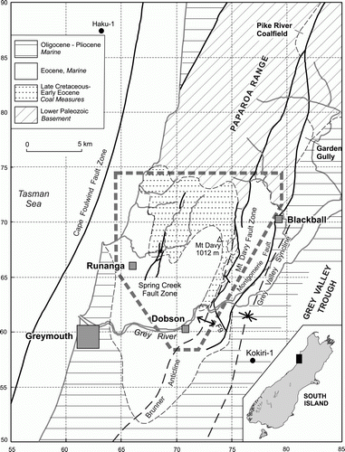
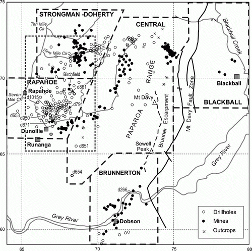
Figure 2 Greymouth Coalfield: distribution of analytical data (Suggate & Boyd Citation2010). Many drillholes include multiple seams, with multiple analyses for many seams. Many individual mine and outcrop sampling sites have multiple analyses. The named blocks are those parts of the coalfield that are discussed in detail, together with an area in Northwest Greymouth Coalfield (dashed rectangle) considered separately. The grid numbers are in kilometres.
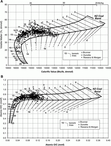
Rank(Sr) of Suggate (2000b) is an indicator of chemical rank that makes allowance for variations in coal type. The rank divisions on the Rank(Sr) charts () provide a scale of equal increments of maximum temperature at which rank was imprinted. The coordinate system used throughout this study is that of the New Zealand Map Grid, with numbers for grid lines in kilometres, thus providing a scale for each diagram.
Figure 3 Greymouth coals in the Rank(Sr) classification. A, On axes of calorific value and volatile matter. B, On axes of atomic O/C and H/C. Approximate Rank(Sr) ranges are: Lignite 0–5, Subbituminuous 5–8, Bituminous 8–16, Semianthacite 16–20.
Stratigraphy and structure
The principal (Paparoa Group) coal measures of Greymouth Coalfield were deposited in the Greymouth Coalfield Basin during the late Cretaceous and Palaeocene (Suggate & Waight Citation1999). They were followed in the Eocene by the region-wide Brunner Coal Measures which were succeeded by the marine Rapahoe Group, deposited in the Paparoa Trough. The Rapahoe Group is overlain by the region-wide Oligocene Cobden Limestone. Neogene deposits, thick in the Grey Valley Trough to the east of the coalfield, originally extended to at least the east and west margins of the coalfield. The detailed stratigraphic nomenclature in is adopted for this study. The thicknesses of all individual units of the Paparoa and Rapahoe groups vary widely, resulting in major thickness variations and resultant variations in coal rank across the coalfield.
Table 1 The basic stratigraphic sequence (after Gage 1952 and Nathan 1974).
Gage (1952) described the structure of the coalfield as a ‘complex, southwards-plunging, asymmetrical anticlinorium, the steep east limb of which borders a deep syncline filled with Upper Tertiary sediments’ (the Grey Valley Syncline). From his mapping, however, the east limb of the anticlinorium extends for c. 4 km east from the steep strata associated with the Mt Davy Fault Zone (), and this part of the east limb is not strongly folded. The broad west limb of the axial structure, the Brunner Anticline, was shown by Gage (1952) to be much folded and faulted over a wide range of scales, being interrupted principally by the Spring Creek Fault Zone (). Although synsedimentary movement is inferred from detailed recent investigations of the area northeast of Rapahoe, most deformation presumably took place as Neogene inversion of the basin progressed.
Previous estimates of depth of burial and palaeotemperature
An estimate of maximum burial can be made by assuming that the vertical rank (and hence temperature) gradients extended uniformly from the coal measures to the surface at the time of maximum burial; oil wells in the Taranaki Basin 350 km to the northeast demonstrate such uniform temperature gradients (Suggate Citation2002). Previous authors have accepted maximum post-Brunner burial at the conclusion of deposition of the Cobden Limestone across the Paparoa Trough. A burial thickness of c. 1.8 km (Gage Citation1952, Fig. 12, 13, cross-sections) contrasts with 4 km at the highest coal rank zone near the crest of the Brunner Anticline (Wellman Citation1952, plate XVII, ). Comparably, 4.3 km estimated by Suggate (1959) contrasts with 2.8 km by Nathan (Citation1978, cross-section). Using fission track thermochronology and vitrinite reflectance, Kamp et al. (1999) estimated a maximum burial depth of the Rewanui Coal Measures of c. 6.2 km, equating to c. 5.7 km for the Brunner Coal Measures. All these studies assumed uniform palaeogeothermal (and hence vertical rank) gradients over the whole coalfield.
Using fission track thermochronology and vitrinite reflectance, Kamp et al. (1999) estimated burial temperatures ranging from 85 °C in the west of the coalfield to 180 °C at the Mt Davy Fault Zone.
Vertical coal rank variation
Method of study
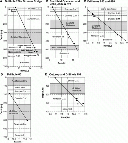
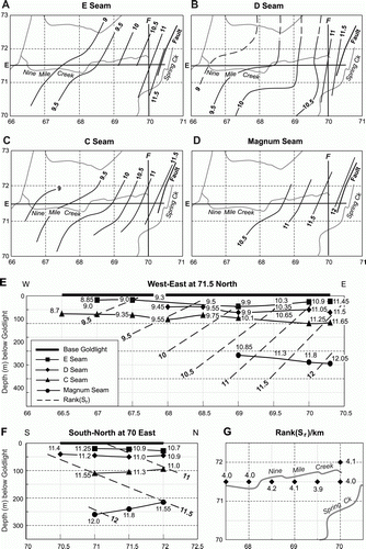
Ideally, any two Rank(Sr) values at different depths in a drillhole would provide a vertical rank gradient. In practice, the precision of individual Rank(Sr) determinations, estimated at ±0.6 (Suggate Citation2000b), makes this impractical where the vertical interval is short. Few drillholes provide a useful interval, nominally taken as at least 200 m. Drillholes through steeply dipping strata have been avoided, but dips are generally <20°. Taking account of the limitations, only a small number of individual drillholes provide useful direct indications of vertical rank gradients; those discussed by Suggate & Boyd (2010, appendix 7) are shown on Fig. 4. An alternative approach is to use the patterns of Rank(Sr) variation for successive seams or seam horizons () in conjunction with patterns of thickness variation between them. This approach is used here for seams up to 200 m apart in Strongman–Doherty Block, and seam horizons up to 300 m apart in both Central Block and the northwest of the coalfield as a whole (including Rapahoe Block and the western Strongman sector of the Strongman–Doherty Block). Vertical rank gradients for all individual coalfield blocks are later integrated into a pattern for the whole coalfield.
Table 2 Principal seam horizons and coal seams
Strongman–Doherty Block
Lateral rank patterns are shown for four seams (Suggate & Boyd Citation2010) (A–D) and the increase of rank with depth is generalised in two cross-sections (E, F). At 0.5 km spacing of grid lines, both the west–east and south–north cross-sections show vertical gradients within the small range of 3.8–4.2 Rank(Sr)/km, indicative of a general gradient of 4.0 Rank(Sr)/km (G). These values are incorporated into Fig. 6D covering the Northwest Greymouth Coalfield within which the Strongman–Doherty Block lies.
In the east, the slopes of the isorank surfaces in the west–east and south–north cross-sections together result from a dip of c. 7° to the WNW with respect to the base of the Goldlight Mudstone. At the time the rank pattern was imprinted, the base of the Goldlight Mudstone was therefore inclined c. 7° to the ESE, presumably towards the depocentre of the basin at the time of maximum burial. The slopes of the west–east isorank surfaces decrease westwards, indicating a diminishing inclination on the base of the Goldlight Mudstone. As a comparison, reflectance data (Boyd & Lewis Citation1995, Fig. 14) were used to infer a general 10° eastward inclination of the base of the Rewanui Coal Measures with respect to isoreflectance surfaces.
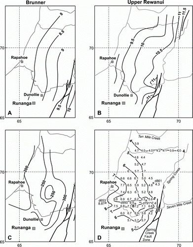
Northwest Greymouth Coalfield
Except in the Strongman–Doherty Block, intervals between seams within the Rewanui Coal Measures are insufficient for estimation of vertical rank gradients. Instead, the intervals between the Upper Rewanui and Brunner coal horizons (C) are used with the Upper Rewanui and Brunner rank patterns from Suggate & Boyd (2010) (A,B) to derive Rank(Sr)/km values at 1 km interval grid intersections (D). Vertical rank gradients based on the cross-sections for the Strongman–Doherty Block (G) are included on Fig. 6D with the most westerly value (at grid reference 675715) similar to nearby values from sequences to the southwest, despite being derived from different vertical sequences.
Several drilled sequences in the east of the Rapahoe Block (B, C, E) are deep enough to provide local rank gradients. At Birchfield Opencast (grid reference 682692), the estimated vertical rank gradient of 4.3 Rank(Sr)/km estimated from nearby drillholes 861, 864 and 877 is close to the 4.6 estimated at the grid intersection 680690, supporting a low gradient in the northeast of the Rapahoe Block. To the south, outcrop data and d791 (grid reference 677680) indicate a gradient of 7.35 Rank(Sr)/km. A short distance to the west, d950 (grid reference 669677) provides an exceptionally high vertical rank gradient of 9.5 Rank(Sr)/km. These drillholes are in an area with generally high gradients estimated at grid intersections. In the west of Rapahoe Block, the vertical rank gradient of 8.8 Rank(Sr)/km at d653 (grid reference 648678) (Appendix) is poorly controlled by the estimates of Rank(Sr) and of the thickness between the Brunner and Upper Rewanui horizons. Nevertheless, the gradient is consistent with the generally high western gradients.
Figure 4 Rank(Sr) versus depth in individual drillholes. A, Brunnerton Block, d266 and Brunner Seam. B, Rapahoe Block, Birchfield Opencast and d861, d864 and d877. C, Rapahoe Block, d950 and d698. D, Southwest Central Block, d651. E, Rapahoe Block, outcrop and d791. Drillhole locations are shown in .
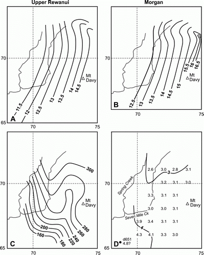
Central, Brunnerton and Blackball blocks
No useable analytical data are available above the Upper Rewanui coal horizon in the main Mt Davy area of Central Block. Isorank lines for the Upper Rewanui and Morgan coal horizons (A, B) cover substantially similar areas, and the thickness between them (Fig. 6C) is adequate to provide good vertical rank gradients. The gradients, calculated at grid intersections from these thicknesses and the Rank(Sr) differences, range from c. 2.75 to 3.4 Rank(Sr)/km (D). In the southwest of Central Block, the gradient for d651 (grid reference 686655) (D, ) depends on only two Rank(Sr)values, but the vertical interval is >300 m. In Brunnerton Block, a single vertical rank gradient of 3.5 Rank(Sr)/km comes from d266 (grid reference 721624) (A, ). In Blackball Block, where the vertical rank gradient cannot be inferred as only the Brunner seam is present, a gradient of 4 Rank(Sr)/km is assumed.
Vertical rank gradients over the whole coalfield
Rank gradients from and are combined into . Using d266 in Brunnerton Block and d651 in the southwest of Central Block, an extension southwards of the 4 Rank(Sr)/km line in eastern Strongman/Doherty Block to the Dobson area in Brunnerton Block in the south links the two main areas. This 4.0 Rank(Sr)/km line is continued from the Brunnerton area north-eastwards between the low gradients of the Central Block and the higher gradient assumed for the Blackball Block. A clear contrast between the west and the centre of the coalfield shows not only in the vertical rank gradients themselves, but also in the patterns of the gradient lines. The slow rate of change of gradient across Central and Brunnerton blocks is compatible with change in depth of burial alone, but the rapid rate of change in Rapahoe Block requires a different explanation.
High vertical rank gradients in Rapahoe Block
The vertical rank gradient increases unevenly from c. 4 Rank(Sr)/km in the northeast to > 8.0 Rank(Sr)/km in the southwest, representing a doubling of the temperature gradient in only 3 km. The high rank gradients in the southwest, the rapidity of gradient change and the prominent east–west high gradient zone that cuts across the trend of progressive westward-increasing gradients in the south all indicate that the high gradients result from a cause other than depth of burial. The high gradient values primarily derive from the disparity between the lateral rank patterns: a sinuous Upper Rewanui pattern and a simple Brunner pattern.
In the west of the Rapahoe Block the Brunner horizon averages Rank(Sr) 8.0 (A) and the Rank(Sr)/km gradient is c. 7.0 (D). If the calculated vertical rank gradient continued up to the final depositional surface, only c. 1.1 km of burial would be inferred in this coastal area. Judged by Nathan (1978, cross-section), the sequence above the Brunner is c. 1.3 km thick up to the Cobden Limestone with an unknown thickness of Neogene (recorded by Nathan as >700 m, 7 km to the south) above the limestone. Burial of significantly more than 1.1 km seems certain. Further, the moderate induration of the Kaiata Mudstone in the coastal area contrasts (Gage Citation1952) with the low induration of the mudstone at Garden Gully east of Greymouth Coalfield (); corresponding Rank(Sr) values of the Brunner coal are 8.0 and 5.2. According to the mapping of Nathan (Citation1978), at Garden Gully the seam was buried at least 1.5 km and a significantly greater depth of burial is to be expected in the coastal area. From coal rank and sediment induration a little over 2 km is estimated, and such a depth is compatible with the stratigraphy if some Neogene cover is accepted. A thickness of 2 km above the Brunner Coal Measures would imply a vertical rank gradient of c. 4 Rank(Sr)/km.
Figure 5 Strongman–Doherty Block. A–D, Rank(Sr) in seams E, D, C and Magnum, from Suggate & Boyd (2010). E, F, cross-sections along grid lines 715 North and 700 East. G: vertical rank gradients (Rank(Sr)/km). The grid numbers on A–D are in kilometres.
The simple Brunner lateral rank pattern (A) is a likely imprint of burial under sedimentary cover, whereas the sinuosity of the Upper Rewanui pattern (B) points to the influence of some other factor. Some Upper Rewanui rank values were apparently enhanced beyond those to be expected from maximum burial alone, with the cause of the enhancement isolated from the Brunner Coal Measures by the Goldlight Mudstone. The result was high vertical Upper Rewanui to Brunner vertical rank gradients (D). Heat causing rank enhancement could have come from an igneous intrusion or from a flow of warm fluids from deeper, hotter areas of the sedimentary basin. A sill intruding Goldlight Mudstone in d654 and d655, 2 km to the south of the Rapahoe Block, and thin mineralised veins (Newman Citation2006) cutting coal seams in d965 (grid reference 671671), d1015 (grid reference 671680) and other more recent drillholes within the block indicate post-Rewanui igneous activity. According to Newman (2006), in d965 carbonate ‘pushed apart’ the coal and was intruded into ‘shattered coal’, indicating that the coal was well coalified before the intrusion; vitrinite reflectance however indicated that the vein was not hot enough to have altered the bulk of the coal. In d1015, the coal was altered close to another vein, locally raising the vitrinite reflectance to c. 0.95%; the seam as a whole had a normal reflectance of 0.56%, however. Vesicle spaces in the altered coal included fragments of coke derived from ‘relatively high rank’ coal, presumably carried by fluids from an intruded seam near the site of the generation of the vein, late in the filling of the Paparoa Trough. No Eocene volcanics are known on the West Coast, but Oligocene volcanics are present in south Westland and tuffaceous Oligocene limestone occurs in Slate Creek, Mikonui valley, 60 km south of Greymouth Coalfield and possibly further north (Schofield Citation1951). An Oligocene age for both the sill in the Goldlight Mudstone and the mineralised veins is possible. The main intrusion giving rise to these veins will have been remote from the drillhole sites; if it had been close, the lateral rank pattern of the Brunner coals would more closely resemble the Upper Rewanui rank pattern. Igneous heating as a cause of Upper Rewanui rank variations seems improbable.
Figure 6 Northwest Greymouth Coalfield. A, B, Rank(Sr) in the Upper Dunollie/Brunner and Upper Rewanui seams horizons from Suggate & Boyd (2010, and ). C, Thickness (m) between the Brunner and Upper Rewanui seams horizons from Suggate & Boyd (2010, Fig. A10a). D, Vertical rank gradients (Rank(Sr)/km). The grid numbers are in kilometres.
The Goldlight Mudstone could have sealed the Brunner coal horizon from heating if the transport of heat was in fluids, principally water, permeating sub-parallel to lithological contacts in the Rewanui Coal Measures. An indication of such transport is the presence of oil in drillhole 653, the most westerly in the coalfield (Appendix). Although flowing from the Brunner Coal Measures, the oil was identified as having a Cretaceous source by Killops (Citation1996). It is likely to have migrated up a fault zone identified a few metres below the Brunner, as tentatively suggested by Bowman (Citation1984). The coal in the thin Rewanui Coal Measures at d653 is Rank(Sr) c. 9.1, too low for the beginning of oil expulsion which occurs at Rank(Sr) 11 in the most oil-prone coals (Sykes & Snowdon Citation2002). Young (Citation1967) documented oil, probably generated locally in the Rewanui Coal Measures, Waiomo Mudstone or Morgan Coal Measures in mine workings and drillholes centred on grid reference 709692 in Central Block where the Rank(Sr) values are 12.3–12.5. Oil migration reaching d653 will have started no further west than the east edge of Rapahoe Block, presumably before migration pathways were blocked by the many minor faults and folds now present in the intervening area. The timing of oil migration is likely to have been close to that of maximum burial.
The pattern of vertical rank gradients may indicate that a flow of warm fluids into the Rapahoe Block originated in the Seven Mile Creek area around grid reference c. 685675 in the most closely faulted part of the Spring Creek Fault Zone, and dispersed westwards from there. Westward thinning of the Rewanui Coal Measures would have aided the migration of oil towards d653. In the early stages of basin inversion, the fault zone could have provided a pathway for warm upwelling fluids. They may also have penetrated northwards along the Spring Creek Fault Zone, leading to a complex pattern of Rank(Sr) in Upper Rewanui coals north-northeast from Seven Mile Creek (Suggate & Boyd Citation2010, Fig. 22).
Estimates of depths of burial and palaeotemperatures
Only the Brunner Coal Measures extend over the greater part of the coalfield, so that they provide the most useful stratigraphic unit from which to calculate burial depths. The vertical rank gradients have however been derived by using Paparoa Group data. Whereas these gradients are accepted as having extended to the surface at the time of maximum burial in areas of low lateral gradient change – the Central, Brunnerton and northeast of Rapahoe blocks – they are rejected in most of the Rapahoe Block where high and rapidly changing gradients are attributed to enhanced heating of the Rewanui Coal Measures. A regional vertical rank gradient of 4 Rank(Sr)/km, as in the northeast of the block, is assumed there. A gradient of 4 Rank(Sr)/km is also assumed in the Blackball Block, where the vertical rank gradient is not known.
Depths of burial
The burial depth of the Brunner coal horizon west of the Mt Davy Fault Zone (B) has been directly calculated where the pattern of lateral rank variation for that horizon is available (A, A). Elsewhere the Upper Rewanui burial depth has been calculated, with the thickness between the Brunner and Upper Rewanui coal horizons then subtracted. The zone of deepest burial lies close to and west of the axis of the Brunner Anticline. Along this zone, the basin was shallowest in the south but still over 2.5 km deep within the coalfield. Further south, the ranks of Brunner and Paparoa coals decrease (Suggate & Waight Citation1999), perhaps indicative of a continued shallowing of the trough. In contrast, the width of the trough in the north emphasises the northwards continuation of the deep part of the Paparoa Trough beyond Greymouth Coalfield, possibly as far as or beyond the Pike River Coalfield () (cf. Nathan et al. Citation1986, map 13).
Figure 7 Central Block. A, B, Rank(Sr) in the Upper Rewanui and Morgan seam horizons from Suggate & Boyd (2010, Fig. 17). C, Thickness (m) between the Upper Rewanui and Morgan seam horizons, from Suggate & Boyd (2010, Fig. A10b). D, Vertical rank gradients (Rank(Sr)/km). The grid numbers are in kilometres.
Significant contrasts in Brunner burial depths are evident between the northwest of the coalfield, the central area and the eastern area between the Mt Davy Fault Zone and Blackball (B). Little lateral change in burial depth is apparent within the northwest and the eastern areas: 1.8–2.2 km in the northwest and 2.2–2.5 km in the east. The central area shows a progressive eastward increase in burial depth to c. 4.3 km, c. 1.5 km west of the Brunner Anticline. From the maximum, the decrease across the Mt Davy Fault Zone into the Blackball Block is abrupt and would remain so even if the assumed vertical rank gradient in the Blackball Block were as low as 3 Rank(Sr)/km rather than 4 Rank(Sr)/km. At Blackwater Creek (grid reference 754693) the Rank(Sr) value of Jay Formation coal immediately west of the Mt Davy Fault Zone is 15.9, whereas that of Brunner coal immediately east of the fault zone is 9.8. At a vertical rank gradient of 4 Rank(Sr)/km, the 6.1 Rank(Sr) difference represents a 1.5 km difference in depth of burial. In that area, the Paparoa Group thickness – which includes volcanics in the Morgan Coal Measures that have thickened eastwards (Gage Citation1952, ) – is c. 1 km. Accordingly, c. 0.5 km of the estimated burial difference between Jay and Brunner is ascribed to fault movement during deposition of the post-Brunner Rapahoe Group cover. Normal faulting is consistent with extension and subsidence of the basin during post-Brunner deposition and is shown in cross-sections A and B in . Other evidence of syn-sedimentary faulting within the basin has been inferred in the Brunnerton area to the south (Suggate & Boyd Citation2010) (, cross-section C) but the Dobson Fault, in contrast to the Mt Davy Fault Zone, was not reactivated during late Neogene deformation.
Figure 8 Pattern of vertical rank gradients (Rank(Sr)/km) for the whole coalfield. High gradients west of Spring Creek result from local heating of Rewanui coals, which has not affected other areas. A general gradient of 4 Rank(Sr)/km is assumed in the east. The grid numbers are in kilometres.
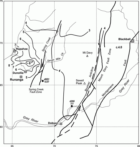
Figure 9 Brunner coals. A, Rank(Sr) pattern for Brunner coals in the Brunnerton area from Suggate & Boyd (2010, Fig. 18). B, Depth of burial (km) of the Brunner coal horizon over the whole coalfield. The grid numbers are in kilometres.
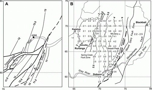
Figure 10 Greymouth Coalfield, west–east cross-sections at the time of maximum burial. A, Along 710 North. B, Along 670 North. C, Along 610 North.
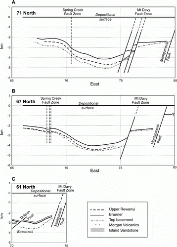
and cross-sections A and B in indicate that the Spring Creek Fault Zone is less clearly related to the western edge of the central deeply buried area than the Mt Davy Fault Zone to the eastern edge, especially in the south where the main strands of the Spring Creek Fault Zone are separated by c. 1 km. and illustrate a sedimentary basin within which a developing major fault zone lay along the eastern side of a central area of deepest subsidence. That fault zone did not however bound the Paparoa Trough, which extended east to the Montgomerie Fault. Although Gage (1952), Nathan (Citation1978) and Kamp et al. (1999) accepted maximum burial at the end of deposition in the Paparoa Trough, Suggate (2000a) suggested that some Neogene sedimentation may have extended across the trough before inversion thus constituting part of the post-Brunner cover.
Palaeotemperatures
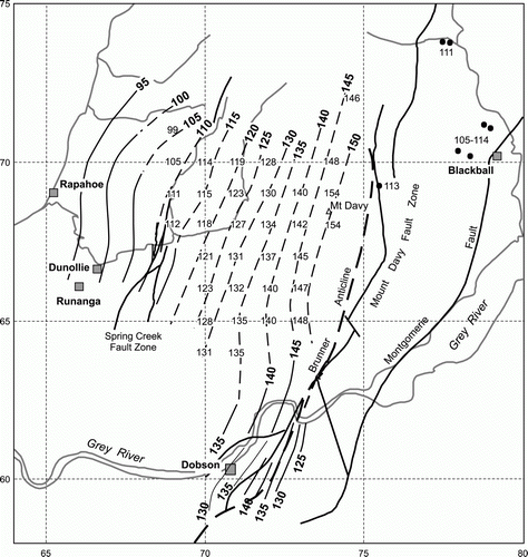
Suggate (2002) inferred that the relation between palaeotemperature and Rank(Sr) could be expressed by the equation Temp (°C) = 10×Rank(Sr) + 15. Using this equation, shows palaeotemperatures at the Brunner coal horizon at the time of maximum burial, derived either directly from Rank(Sr) at the Brunner coal horizon or indirectly from the Upper Rewanui coal horizon. A Brunner palaeotemperature in the Paparoa Mine area (grid reference 746720) is derived from the Lower Rewanui rank in that mine. Direct comparison is not possible with the Rewanui palaeotemperatures of Kamp et al. (1999, ), but the patterns are broadly similar. In the Mt Davy area the Brunner palaeotemperature is estimated at 150–55 °C, whereas the Rewanui palaeotemperature of Kamp et al. was 155–160 °C. In that area, an adjustment of 12.5 °C was made between Upper Rewanui and Brunner for , leading to a palaeotemperature c. 7.5 °C greater than that of Kamp et al. In the low-rank western area, the Brunner palaeotemperatures in are similar to Kamp et al.'s Rewanui palaeotemperatures despite a 250 m stratigraphic separation equivalent to c. 10 °C.
Figure 11 Palaeotemperatures (°C) of the Brunner coal horizon at the time of maximum burial. Full lines derive from Brunner Rank(Sr) values. Values at grid intersections are calculated from Upper Rewanui Rank(Sr) values, and that at 746720 (Paparoa Mine) is from the Lower Rewanui. East of the Mt Davy Fault Zone, the values are based on the Brunner seam. The grid numbers are in kilometres.
One factor in the palaeotemperature estimates of Kamp et al. (1999) was a palaeogeothermal gradient of 29 °C/km adopted from hydrocarbon wells in Taranaki, a region thought by Kamp et al. (1999) to include Greymouth Coalfield. Present temperature gradients southwest of Greymouth Coalfield are, however, 38–43 °C/km (Suggate & Waight Citation1999). At Sewell Peak ( and B) the use of 29 °C/km led to an estimate of 6.3 km of cover on the Rewanui Coal Measures (Kamp et al. Citation1999), equivalent to c. 5.8 km on the Brunner Coal Measures. The vertical rank gradient there is c. 3.5 Rank(Sr)/km (), with a corresponding vertical palaeogeothermal gradient of c. 35 °C/km (Suggate Citation2002). Using this higher gradient would reduce Kamp et al.'s estimate to c. 4.8 km, closer to that of 4.0 km estimated here (B). Despite uncertainties in all the estimates, it is probable that underestimate of the palaeogeothermal gradient led Kamp et al. (1999) to overestimate the palaeotemperatures and burial depths.
Conclusions
Vertical rank gradients, calculated from sequences of seams in a few drillholes and elsewhere from generalised lateral rank patterns in overlapping areas of successive seams, are lowest (c. 3 Rank(Sr)/km) in the centre of the coalfield and highest (c. 8 Rank(Sr)/km) in the west of the Rapahoe Block. There, where the Upper Rewanui lateral rank pattern is markedly sinuous, particularly high vertical gradients are attributed to enhanced Rank(Sr) values in Rewanui coal seams heated by warm fluids from deeper higher-rank areas to the east. Close to the time of maximum burial, these fluids migrated up and along the Spring Creek Fault Zone to its most closely faulted part and then dispersed westwards in the Rewanui Coal Measures. The Brunner Coal Measures were insulated from hydrothermal heating by the Goldlight Mudstone.
Varying burial depth is accepted as the dominant cause of lateral rank changes. Calculated vertical rank gradients are assumed to have continued to the surface through the post-Brunner cover at the time of maximum burial, except for those in the area of high vertical rank gradients in the west of the Rapahoe Block (where a gradient of 4 Rank(Sr)/km, as in the northeast of the block, is assumed). This gradient is also assumed east of the Mt Davy Fault Zone. Using the vertical rank gradients, burial depths of the Brunner Coal Measures have been calculated either directly where their lateral coal rank pattern is available or indirectly from the Upper Rewanui pattern. They increase from c. 2 km in the west to c. 4.3 km close to the Mt Davy area, with c. 2.4 km east of the Mt Davy Fault Zone which was apparently active during post-Brunner deposition. The maximum Brunner palaeotemperature, in the Mt Davy area, is estimated to be c. 150 °C.
The results, particularly on burial depths, contribute principally to the understanding of the development of Late Cretaceous and Cenozoic sedimentary basins in northwest South Island. The methods used, in sequence from lateral rank patterns through vertical coal rank gradients to depths of burial, are applicable to any coalfield with multiple coal seams, provided the seams are adequately separated stratigraphically and there are sufficient coal analytical data. In New Zealand, these conditions may be satisfied at Ohai Coalfield.
Acknowledgements
Use of analytical data from the Solid Energy database, essential to the project, is gratefully acknowledged. Data have also been obtained from the Ministry of Economic Development's coal database. The authors have welcomed discussions with Jane Newman (Newman Energy Research) and Jonny McNee (Solid Energy) at different stages as the manuscript progressed. Particular thanks go to Richard Sykes and Carolyn Hume (GNS Science). The manuscript was significantly improved following comments from reviewers and the editor.
References
- Bowman RG 1984 Wellington . Greymouth Coalfield report, New Zealand Coal Resources Survey . Unpublished report to Mines Division , Ministry of Energy .
- Boyd , RJ and Lewis , DW . 1995 . Sandstone diagenesis related to varying burial depth and temperature in Greymouth Coalfield, South Island, New Zealand . New Zealand Journal of Geology & Geophysics , 38 : 333 – 348 .
- Gage M 1952 . The Greymouth Coalfield . New Zealand Geological Survey Bulletin 45 . 232
- Kamp , PJJ , Whitehouse , IWS and Newman , J . 1999 . Constraints on the thermal and tectonic evolution of Greymouth coalfield . New Zealand Journal of Geology & Geophysics , 42 : 447 – 467 .
- Killops S 1996 . A geochemical perspective of oil generation in New Zealand . In: Proceedings of 1996 New Zealand Oil Exploration Conference , 1 Energy and Resources Division, Ministry of Commerce Wellington , 179 – 187 .
- Nathan , S . 1974 . Stratigraphic nomenclature for the Cretaceous–Lower Quaternary rocks of Buller and north Westland, West Coast, South Island, New Zealand . New Zealand Journal of Geology & Geophysics , 17 : 423 – 445 .
- Nathan S 1978 . Sheet S44–Greymouth . Geological map of New Zealand 1:63360 . Wellington , , New Zealand : Department of Scientific & Industrial Research .
- Nathan S, Anderson HJ, Cook RA, Herzer RH, Hoskins RH, Raine JI, Smale D 1986 . Cretaceous and Cenozoic sedimentary basins of the West Coast , South Island , New Zealand . New Zealand Geological Survey Basin Studies Report 1 .
- Newman J 2006 . Samples G06-1605 progress report; Samples G04-4715 (ply 12) & G04-4716 (ply 13) mineralized coal from Spring Creek drillhole 965; Romax% and macerals for samples G06-1754 and G06 2699 . Unpublished internal Solid Energy New Zealand report .
- Schofield , JC . 1951 . Distribution of Lower Oligocene volcanics in New Zealand . New Zealand Journal of Science & Technology , 33 : 201 – 217 .
- Suggate RP 1959 . New Zealand coals . New Zealand Department of Scientific and Industrial Research Bulletin 134 .
- Suggate , RP . 1974 . Coal ranks in relation to depth and temperature in Australian and New Zealand oil and gas wells . New Zealand Journal of Geology & Geophysics , 17 : 149 – 167 .
- Suggate , RP . 2000a . Constraints on the thermal and tectonic evolution of Greymouth coalfield – Discussion . New Zealand Journal of Geology & Geophysics , 43 : 651 – 653 .
- Suggate , RP . 2000b . The Rank(Sr) scale. Its basis and its applicability as a maturity index for all coals . New Zealand Journal of Geology & Geophysics , 43 : 521 – 553 .
- Suggate , RP . 2002 . Application of Rank(Sr), a maturity index based on chemical analyses of coals . Marine and Petroleum Geology , 19 : 929 – 950 .
- Suggate RP, Waight TE 1999 . Geology of the Kumara-Moana area . Institute of Geological and Nuclear Sciences Geological Map 24 .
- Suggate RP, Boyd RJ 2010 . Greymouth Coalfield, New Zealand: coal ranks in the context of basin development . Ministry of Economic Development , New Zealand , unpublished coal report CR3388 .
- Sykes , R and Snowdon , LR . 2002 . Guidelines for assessing the petroleum potential of coaly source rocks using Rock-Eval pyrolysis . Organic Geochemistry , 33 : 1441 – 1455 .
- Wellman HW 1952 . Interpretation and discussion of analyses . Chapter 12. In : Gage M ; The Greymouth Coalfield . New Zealand Geological Survey Bulletin 45 . 78 104 .
- Young , DJ . 1967 . Oil-bearing Paparoa Coal Measures near Rewanui, Greymouth Coalfield . New Zealand Journal of Geology & Geophysics , 10 : 666 – 674 .
Appendix: Rapahoe Block: drillhole 653
This drillhole (grid reference 648678) is the most westerly in Greymouth Coalfield. From Kaiata Mudstone at the surface, it penetrated Island Sandstone, Brunner Coal Measures, Dunollie Coal Measures and Goldlight Mudstone above thin Rewanui Coal Measures that rest directly on basement at a depth of 564 m. The drillhole summary records ‘possible structural complication’ at 377.2 m between Island Sandstone and Brunner Coal Measures, but the lithology log notes only a sharp lower contact to the Island Sandstone, which is not unusual in the context of field observations in the west of the coalfield. The drillhole summary also records ‘possible structural complication’ at 397.2 m, without describing the sequence from 397.2 m to 400.7 m. The lithology log shows this to be 3.5 m of shattered and slickensided Island Sandstone underlain by Dunollie Coal Measures and a sliver of Island Sandstone at 402.3 m. Shearing and crushing in the Dunollie Coal Measures diminishes downwards to 410.6 m. A fault zone from c.397 to c. 403 m is inferred, with parts of the Brunner and Dunollie coal measures cut out at the fault. Judged by the nearest drillholes, both of these are close to their likely thicknesses with a total of c. 30 m missing at the fault. A small flow of oil took place at or near 394.8 m, a few metres above the fault zone in Brunner Coal Measures.