Abstract
Although experiencing some seismicity, the Auckland region is generally considered to be one of New Zealand's most tectonically stable areas. There is a distinct lack of mapped faults in the central Auckland area, yet regional trends indicated by several mapped faults surrounding it suggest that these faults should continue through Auckland. The overprint of Auckland Volcanic Field (AVF) deposits may mask any potential fault traces in the area. We carried out a detailed study of the topography of Auckland concealed beneath the AVF deposits, using borehole and geophysical data, and combined this with structural information gleaned from current topography and exposed geology to identify significant concealed fault offsets. The reliability of each potential fault displacement was determined using pre-defined attributes. The resulting block faulting model for Auckland supports the proposed connection between the position of the Junction Magnetic Anomaly and Auckland volcanism. The identification of several possible faults in the area covered by the AVF might indicate more structural control on volcanism than previously thought.
Introduction
The Auckland region is considered to be one of New Zealand's most tectonically stable areas and only one fault from the region appears in the GNS Science active faults database (Wairoa North Fault in the Hūnua Ranges, Edbrooke Citation2001). Despite this, the area does experience low-level seismicity; since 1983, the Auckland seismic network has recorded c. 80 earthquakes above c. M L 2.5 (Sherburn et al. Citation2007). The Kerepēhi Fault within the Hauraki Rift to the east and south of Auckland is still considered to be active (De Lange & Lowe Citation1990).
Many older inactive faults have been mapped in the Auckland region, particularly to the southeast in the Hūnua Ranges, and in the west in the Waitākere Ranges (e.g. Hayward Citation1983; Edbrooke Citation2001). Northern Auckland is structurally complex due to the southward nudging of the Northland Allochthon into the area (Kenny et al. Citation2010). Several faults in the Manukau Lowlands and on the Āwhitu Peninsula have also been inferred, based on geophysical data and borehole information (e.g. High Citation1977). In previous studies, there was a distinct lack of mapped faults in the central Auckland area. This can partially be explained by the overprint of Late Quaternary deposits of the Auckland Volcanic Field (AVF) masking faults in the underlying rocks.
The 2010–2011 Canterbury earthquakes have highlighted the potential for unknown faults to cause significant damage and loss of life in built-up areas in New Zealand (Reyners Citation2011). Although the seismic hazard in Auckland is low (Stirling et al. Citation2002; Sherburn et al. Citation2007), the presence of low-level seismicity together with numerous faults of unknown age surrounding the central Auckland area indicates that there could be concealed faults in central Auckland. Unknown concealed faults could have implications for seismic hazard in the region and also for volcanism, as pre-existing faults may provide future magma ascent pathways. However, given the lack of active faults in the region as a whole, it is unlikely that any concealed faults beneath central Auckland would be classed as active.
Here we present a detailed study of existing borehole and geophysical data combined with structural information gleaned from current topography and exposed geology to identify previously unrecognised concealed faults in the Auckland region. In particular, we use the Late Miocene erosional surface of the Early Miocene Waitematā Group sediments as a marker horizon for recognising lithological offsets.
The main aims of the study are to:
| • | develop new fault maps for the Auckland region that include inferred concealed faults; | ||||
| • | gain a better understanding of the crustal structure beneath Auckland, in particular depths to key geological boundaries; and | ||||
| • | investigate whether there is any relationship between the faults in Auckland and the location of past AVF eruption centres. | ||||
Regional geological setting
The Auckland region lies within the Australian Plate, 400 km west of the present plate boundary with the Pacific Plate (Smith Citation1989; inset).
Figure 1 Simplified geology map for the area surrounding the Auckland region. Inset: Plate boundary through New Zealand. Box: the area enlarged in .
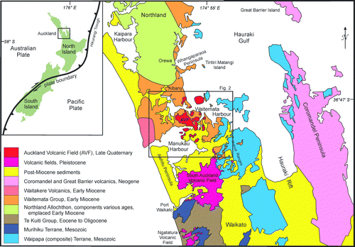
The basement in the Auckland region consists of three Late Palaeozoic–Early Mesozoic NNW-trending terranes associated with a subduction zone that was active in Late Jurassic–Mid-Cretaceous times. The westernmost terrane is the greywacke- and argillite-dominated Murihiku Terrane (; Isaac et al. Citation1994). The easternmost terrane () is a greywacke and argillite assemblage of the Waipapa (composite) Terrane (Spörli Citation1989). Separating the two is the Dun Mountain–Maitai terrane, made up largely of variably serpentinised ultramafic ophiolitic rocks that are inferred to be the source of the strong NNW-trending gravity and magnetic anomalies known collectively as the Junction Magnetic Anomaly (JMA) (Woollaston Citation1996; Sivell & McCulloch Citation2000; Eccles et al. Citation2005; Williams et al. Citation2006; Cassidy & Locke Citation2010).
The JMA occurs as a 6–8-km-wide band along the length of New Zealand. In the Auckland region it widens abruptly to form a complex zone of subparallel lineaments up to 14 km wide, extending from the Auckland isthmus northwards for about 30 km. This unusual widening is thought to represent a pod of up to 10 NNW-trending serpentinised shears (Eccles Citation2003; Eccles et al. Citation2005; Cassidy & Locke Citation2010) with a flat upper surface reaching to within 500 m of the ground surface (Williams Citation2003).
Greywacke basement rocks outcrop east of a line from Tiritiri Matangi Island in the north to Papakura in the south (, ) and are known to be present at depth in some locations west of this line from borehole data. Boreholes in the Henderson Valley encountered greywacke 485 m below sea level, and a borehole on the Āwhitu Peninsula reached greywacke at 340 m below sea level (Waterhouse Citation1989). Rocks associated with the Dun Mountain–Maitai terrane have not been reached by boreholes and the positions of the terrane-bounding faults are unknown. A borehole in the suburb of Mt Roskill reached a depth of 592 m (532 m below sea level), finishing in basal Te Kūiti Group coal measures, probably within 30 m of basement (Edbrooke et al. Citation1998). The coal measures are the oldest sediments in an Eocene–Oligocene transgressive sequence that accumulated in grabens formed by late Cretaceous block faulting of the basement.
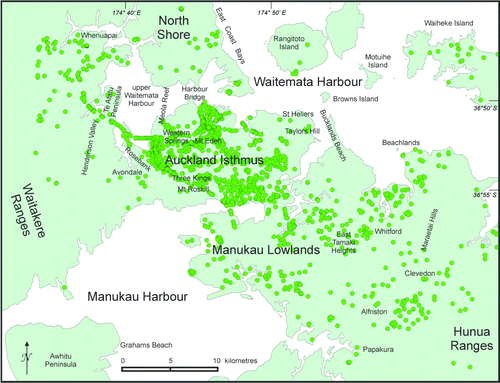
Figure 2 Map of the Auckland region showing boreholes used in this study (green circles) and place names referred to in the text.
At the end of the Oligocene (c. 22 Ma ago) in the Auckland region, Waitematā Group sediments (mainly alternating turbiditic sandstones and mudstones) began accumulating in a rapidly subsiding basin (e.g. Hayward et al. Citation1989; Spörli Citation1989; Isaac et al. Citation1994). The Waitematā Group sediments are now the most common rocks in the Auckland area () (e.g. Ballance Citation1974; Kermode Citation1992). Sporadic, highly deformed intervals up to 100 m thick within the sedimentary pile are interpreted to be associated with emplacement southwards of the Northland Allochthon (; Kenny Citation2008b; Kenny et al. Citation2011).
Sedimentation continued within the subsiding Waitematā basin until at least 17 Ma ago and large-scale block faulting was initiated about 15 Ma ago. The Auckland area was uplifted, eroded (Kermode Citation1992) and subjected to NW–SE then NE–SW extensional forces that created numerous small (outcrop-scale) steeply dipping cross-cutting normal faults (Spörli Citation1989). Plio-Pleistocene sediments were subsequently deposited in depressions formed by block faulting, infilling the valleys in the relatively uplifted Auckland isthmus area (Affleck et al. Citation2001) while overtopping the grabens in the lower-lying Manukau Lowlands area to the south (Berry Citation1986).
The final stage in the geological history of Auckland is the Late Quaternary basaltic volcanism, the products of which now dominate the central Auckland landscape (Lindsay et al. Citation2011).
Previously recognised regional faults
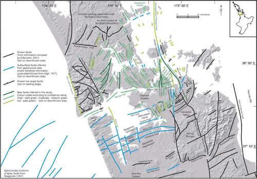
A simplified map of previously recognised and inferred faults () summarises the work of many researchers in the Auckland region. Significant ENE-trending horsts and grabens in the southeast are bounded by a series of normal faults between Whitford and Clevedon (Schofield Citation1979; Kermode Citation1986; Edbrooke Citation2001). They parallel numerous faults mapped in the Hūnua Ranges (Schofield Citation1979) and the major Waikato Fault further south (Hochstein & Nunns Citation1976) that offsets Murihiku greywacke basement by 2.7 km at Port Waikato. They also appear to be analogous to the splay faults offshore in the northernmost Taranaki Basin trending approximately ENE, mapped using seismic evidence by Stagpoole (1997) ().
Figure 3 Faults previously recognised in the Auckland region (see text for the many references).
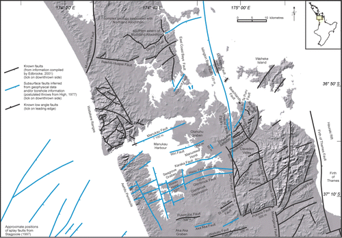
Also paralleling this trend are faults forming a horst and graben pattern in both the basement and Waitematā Group sediments. These ENE-trending faults, with throws ranging from about 75 m to more than 220 m, include Manukau Fault (Ballance Citation1968) that down-drops the Manukau Lowlands region with respect to the moderately elevated Auckland isthmus region (). They also include concealed faults such as the Wiri Fault with smaller offsets, which form horst and graben features across the Manukau Lowlands and are thought to have been active continuously into the latest Pliocene (e.g. High Citation1977; Berry Citation1986; Hull et al. Citation1995).
NNW-trending faults like the Waikopua and Drury faults truncate these horsts and grabens (). Many are thought to be remobilised older faults that extended into the Northland area, inherited from structures in the basement associated with the separation of New Zealand from Gondwana c. 80 Ma ago (Spörli Citation1982; Kamp Citation1986). In the south and east of the area, these NNW-trending faults have been determined by numerous workers using borehole data, gravity surveys and seismic profiling (see review by Kenny et al. Citation2011). The Hauraki Rift, a major 250-km-long structural feature passing east of Auckland (, ) and possibly still active (Hochstein & Nixon Citation1979; Hochstein et al. Citation1986; De Lange & Lowe Citation1990), follows the regionally significant NNW–SSE trend.
To the west of Auckland, the Waitākere Ranges are also bounded by NNW-trending features: andesitic intrusions, dykes, craters and volcanic necks form a 2-km-wide belt along the eastern flank of the Waitākere Ranges and a series of craters and volcanic necks line up along the coastline. Within this Waitākere block, however, faults form a grid pattern with NE and ESE orientations (Hayward Citation1975, Citation1983; ).
To the north of Auckland, most of the structures mapped by Schofield (Citation1989) and others, including the Ōkura Thrust at Albany () and faults in the upper Waitematā Harbour area, are now thought to be associated with the sliding southwards of the Northland Allochthon (e.g. Ballance & Spörli Citation1979; Hayward Citation1982, Citation1993; Spörli Citation1989; Spörli & Rowland Citation2007; Kenny Citation2008b; Kenny et al. Citation2011). One exception is the East Coast Bays Fault (Hayward Citation1982; Ballance & Schofield Citation1983; Schofield Citation1989). Hayward (Citation1982) proposed that the southern extrapolation of this fault could continue southwards across the Auckland isthmus, to potentially link with some northern extension of the Drury Fault.
In the Hauraki Gulf, a N–S-trending fault between Whangaparāoa Peninsula and Tiritiri Matangi Island (Spörli & Rowland Citation2007) was earlier postulated by High (Citation1977) (). He linked this major structure to the N–S-trending Motutapu Fault (Milligan Citation1977) and thought that it could be a northern continuation of the Drury Fault. A major NNW-trending fault between Motutapu and Rangitoto islands was postulated to pass to the east of Bucklands Beach peninsula and continue southwards to the Wairoa North Fault (Milligan Citation1977).
With the complex tectonic history associated with extension- and compression-related faulting regimes surrounding the Auckland area, why is it that so few major faults have been recognised traversing Auckland isthmus itself? Geophysical studies that might have revealed hidden faults are often restricted by Late Quaternary sediments, volcanic ash and lava flows concealing fault traces and subtle anomalies that may occur in the Waitematā Group sediments beneath (e.g. Affleck et al. Citation2001; Williams Citation2003; Murray Citation2010).
Shallow water ‘noise’ in seismic profiles is also a problem, especially in profiles recorded from the Manukau Harbour and middle to upper reaches of the Waitematā Harbour; these profiles have revealed few mesoscopic faults under harbour sediments (Davy Citation2008).
A unique marker horizon: The late Miocene eroded surface
In the Auckland region, the most widespread lithologies are monotonous, subhorizontal, alternating turbiditic sandstones and mudstones of the Waitematā Group. Outcrop-scale faults are ubiquitous (High Citation1975; Spörli Citation1989; Kermode Citation1992); however, any obvious horizons cannot be traced for more than a few hundred metres (Morris Citation1983).
There is only one potential marker horizon that can be followed with any certainty across the Auckland region, namely the late Miocene eroded surface of the Waitematā Group. This has been recognised as a region-wide ‘peneplain’ (Kermode Citation1992; Kenny Citation2007). It is not a ‘palaeo-surface’ sensu stricto, although it is a surface eroded in former times. More precisely, it should be regarded as the best approximation of the top of the Waitematā Group as it exists at the present time (whether concealed and preserved or exposed and affected by subsequent modern erosion), now at various heights above sea level.
Across the northern Auckland isthmus, in western Auckland and on the North Shore, this erosion surface equates to the present topographic surface. To the south, the erosion surface has been down-dropped and is covered by younger material. To the east, the same surface has been up-thrown and largely eroded away (e.g. in the Hūnua Ranges).
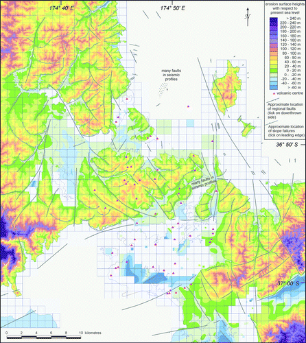
Where this erosion surface is visible, it is not at a constant height above sea level but rather is broken into blocks at subtly different heights. There is height uniformity within blocks but a discordance between blocks ranging, for example, from less than 20 m above sea level at Whenuapai, Te Atatū Peninsula, Avondale and Rosebank, to over 120 m above sea level in the East Tāmaki Heights and Alfriston areas (). A high erosion surface over 350 m above sea level, gently tilted to the northwest, is preserved in the Waitākere Ranges (Hayward Citation1983, Citation2009).
Figure 4 Elevation map of current Auckland topography. Green colours are lowest elevations; purple colours are highest elevations. Heights refer to metres above sea level.
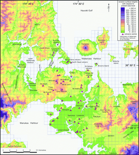
The Manukau Lowlands have been down-dropped relative to other blocks, and in this area boreholes encounter the unconformity between Waitematā Group sediments and overlying lithologies at or below sea level (High Citation1977; Berry Citation1986; Hull et al. Citation1995). Boreholes and geophysical analyses in the central Auckland isthmus area, now covered by volcanic ash and lava, indicate that the underlying Waitematā surface is very irregular, but averages 70 m above sea level (Affleck et al. Citation2001).
It is conceivable that intersecting post-erosion surface faults, as seen in outcrop-scale NE- and NW-trending normal faults as well as in regional fault trends, has caused the discordance of heights. One of the motivations of our study was to investigate the possibility that regional faults traverse Auckland, despite not being represented on published maps.
Methods
Establishing lithological contacts based on borehole data
Data from over 2000 boreholes collated as part of the DEVORA (DEtermining VOlcanic Risk in Auckland) project (Howe et al. Citation2011) have been used to aid in the interpretation of the concealed Waitematā surface and to determine the depth to basement rocks. Drillhole logs based on notes made by drillers or consultant geologists during the drilling process have been stored by the Auckland Council and its predecessors, Watercare, private geotechnical firms, New Zealand Transport Agency and other organisations. The actual core no longer exists. Identification of the Waitematā Group interface with overlying sediments often relied on experienced drillers’ ability to ‘feel’ the change in lithology through the drill bit. A zone of weathered Waitematā Group up to several metres thick was occasionally recognised by drillers at the interface. We rigorously assessed the data and logs with questionable interpretations were disregarded. There are a few areas with large gaps in the coverage and contouring of the Waitematā surface in these poorly constrained areas has not been attempted.
Approximately 55% of the boreholes penetrated into Waitematā Group sediments and a further 5% reached basement greywacke, either through Waitematā Group (and occasionally also Te Kūiti Group) or directly beneath superficial post-Miocene sediments. Of the remaining 40%, just under half ended in products of the AVF and just over half ended in post-Miocene sediments or fill. These latter drillholes were nevertheless still useful in providing a ‘deeper than’ indication for the top of the buried Waitematā Group.
Establishing the concealed Waitematā Group erosion surface
Depths to the Waitematā Group erosion surface derived from borehole logs were plotted and manually contoured in 20 m intervals. Manual contouring was necessary in order to take into account all non-numerical constraints. The following assumptions were made.
| 1. | We assume the buried Waitematā Group erosion surface, where unfaulted, should have a similar gross geomorphology to the exposed Waitematā Group erosion surface. We assume that any significant sudden differences in elevation (> 20 m) in the Waitematā Group erosion surface on the ridges are related to tectonic activity. | ||||
| 2. | As lava usually flows down topographic lows, the path of AVF lava flows pinpoints pre-existing valleys in the Waitematā Group erosion surface. | ||||
| 3. | Tuff conceals the erosion surface around the volcanoes. However, the more distal tuffs only amount to a relatively thin veneer that we assume tends to mantle the pre-existing topography; ridges and valleys of the underlying landscape may therefore be interpreted with increasing precision with distance from the vents. | ||||
Positioning of large-scale faults in the Auckland region, based on pre-selected attributes
We selected the following eight attributes to identify the location of potential large-scale faults in the Auckland region ():
| • | a sudden significant offset (> 20 m) in the concealed Waitematā Group erosion surface, as revealed by borehole data (‘borehole information’); | ||||
| • | a sudden significant difference in elevation (> 20 m) of the currently exposed Waitematā Group erosion surface (‘topographic offset’); | ||||
| • | non-sedimentological juxtaposition of exposed lithologies (‘lithologic offset’); | ||||
| • | the presence of strong lineaments as revealed in aerial photographs and documented in Kenny (Citation2008a) and Kenny et al. (Citation2011) (‘strong lineaments’); | ||||
| • | the truncation of small-scale lineaments related to bedding or joint planes (Kenny Citation2008a; Kenny et al. Citation2011) (‘truncates other lineaments’); | ||||
| • | the presence of long, straight valleys (both exposed and concealed, e.g. by lava flows) (‘long straight valleys’); | ||||
| • | alignment with mapped regional faults that may have as yet unrecognised concealed extensions (‘continuation of known faults’); and | ||||
| • | the presence of faults based on geophysical models outlined in unpublished previous work (‘geophysical data’). | ||||
Table 1 Confidence ratings of new inferred regional faults. Each ‘criterion for recognition’ in the attribute list for each fault is given one point, leading to an individual confidence rating score. Scores of 5 or more are given a high-confidence rating, scores of 3 or 4 a moderate-confidence rating, and scores of 1 or 2 only a low-confidence level.
When examined separately, each attribute gives only an indication that a fault may exist in that vicinity at depth. When all available attributes are combined, however, they add increasing certainty to the existence and placement of concealed faults. To quantify this certainty, we assigned each attribute one point and ranked faults based on a point scale. Proposed faults were assigned a confidence of high, moderate or low if they achieved 5–8, 3–4 or 1–2 points, respectively.
Results
Waitematā Group erosion surface
A new contoured topography map of the upper surface of the Waitematā Group sediments is shown in . It is interesting to compare this map with the present-day topography of Auckland (). Some of the main differences are as follows. The area above present sea level is almost halved in , with seaways linking the Waitematā and Manukau harbours effectively detaching Auckland isthmus and Northland from the rest of New Zealand. Rangitoto and Browns Island volcanoes are absent from .
Figure 5 Topography of the eroded surface of the Waitematā Group as it is today, including portions now concealed under younger sediments or volcanic material. Terrain in the highest eastern areas, where Waitematā Group sediments have been eroded away, is greywacke. Large-scale faults, both published and inferred in this study, have been superimposed. Arcuate faults, related to Miocene sub-seafloor slope failures (Kenny Citation2008b; Kenny et al. Citation2010), are also shown. Areas of white represent areas of unknown depths. Although volcanoes post-date the erosion surface, they are shown here to assist comparison with .
Long, sinuous, gently inclined pre-volcanic valleys protrude far into the Auckland isthmus; these are now filled with huge volumes of lava from the AVF. In times of lower sea level during glacial periods, the upper Waitematā Harbour would have been a lake, dammed by a low ridge of Waitematā Group sediments where the Harbour Bridge is now. A deep depression has also been discovered from borehole data in the Henderson Valley (, left margin) and fault-controlled depressions are postulated at Clevedon and Alfriston (, lower-right corner). Other fault-controlled hollows in the erosion surface could exist in the Manukau Lowlands but, with insufficient borehole coverage, it is impossible to complete the map in this region (, southern third).
Depth to basement
Waipapa terrane greywacke is the dominant rock type to the east of Auckland and many of the borehole logs we examined from the eastern parts of Auckland penetrated down to this lithology. In some boreholes, lithological offsets occur in both greywacke and the Waitematā Group erosion surface. In many cases, the former is significantly greater than the latter. We interpret this as reflecting fault remobilisation.
Greywacke is encountered in successively deeper boreholes in a westward direction, becoming so deep under most of Auckland it has yet to be penetrated. Further west at Henderson and northern Āwhitu Peninsula, boreholes again penetrate greywacke (Edbrooke Citation2001) suggesting that, in western Auckland, basement is uplifted.
Identification of large-scale faults in the Auckland region
Using the attributes described previously, we identified 64 possible faults in the Auckland region. Many of these represent continuations of previously mapped faults. Faults are superimposed on the Waitematā Group erosion surface topography in and are presented in detail in , together with their confidence levels from .
Figure 6 Regional faults, both published and inferred in this study, superimposed on a greyscale map of Auckland. Confidence rating colours have been applied. Fault names have been added. The decrease in fault density in the region south of the Auckland isthmus is probably a function of limited borehole coverage rather than an absence of faults. See Kenny et al. (Citation2011) for data sources.
No faults have all of the 8 recognised attributes (). Of the 64 proposed faults, 17 are ranked as high in our confidence-ranking scheme. Only 4 meet 7 attribute criteria, namely Wiri Fault extension, Bucklands Beach Fault, Oratia Fault and Henderson Fault (; ). Thirty-three faults achieve a moderate-confidence level and 14 have a low-confidence level. For comparison, we also assessed previously recognised faults using our confidence scheme. Inferred faults seen in offshore seismic profiles (fifth to last entry in ) achieved a low-confidence rating. Previously recognised faults coloured blue in , i.e. those described in reports, theses and newsletters that have not been peer-reviewed (fourth to last entry in ), achieved a moderate confidence rating.
Previously recognised faults, represented by black in , have appeared in peer-reviewed literature and have been acknowledged as reliable enough to be included in the QMAP mapping programme (Edbrooke Citation2001). We selected three of these faults, the Waikopua, Papakura and Polo Lane faults, to test our confidence ranking scheme. They achieved high ratings, with two reaching 8 out of 8 (last entries in ).
Discussion
Block faulting in the Auckland region
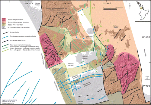
The maps illustrated in , are dominated by NNW-trending proposed faults, most of which are down-thrown to the west. They essentially fill in the gap created by the dearth of faults in previous geological maps of Auckland. Some are inferred to be logical northern extensions of the NNW-trending regional faults displaying NE–SW extension (Spörli & Rowland Citation2007), such as the Drury, Wairoa and Waikopua faults in the southeast of the study area, and are discussed in detail in Kenny et al. (Citation2011). One of the NNW-trending fault systems, from Drury through to Whangaparāoa Passage, forms an important boundary traversing the Auckland region where greywacke outcrops sporadically to its east but no greywacke is known to outcrop to its west. In addition, no volcanoes of the AVF occur east of this boundary.
In the west, the East Scenic Drive Fault is inferred to continue southwards as the Āwhitu Fault. The region between these faults and the Drury to Whangaparāoa Fault system has formed a long NNW-trending graben, bisected by an east–west step at the Manukau Fault. In the graben on the northern side of the step, a series of small NNW-trending faults can be followed across Auckland isthmus to the North Shore area. Because of the paucity of borehole data, these faults have not been traced southwards across the Manukau Lowlands.
A series of NNE-trending splay faults dominate in western Auckland, and have collectively formed a small graben creating the north-western portion of the upper Waitematā Harbour depression. They are similar to faults mapped by Hayward (Citation1983) west of the East Scenic Drive Fault, some of which are compatible with splay faults mapped off the west coast by Stagpoole (Citation1997). The Manukau Fault is also inferred to be related to Stagpoole's (Citation1997) splay faults. It forms the major ENE-trending step just mentioned, north of which the topography is at intermediate elevation. South of the step, across the Manukau Lowlands, the Waitematā Group erosion surface is below sea level. Further south, other ENE-trending faults are part of a north–south extensional regime of horsts and grabens.
The NNW- and ENE-trending faults intersect with various inferred cross-cutting relationships to form a block faulting pattern (). In the south of the area, for example, concealed NNW trends are thought to truncate concealed ENE trends (High Citation1977; Berry Citation1986; Hull et al. Citation1995).
Figure 7 Block elevation map indicating relative heights of the Waitematā Group erosion surface, developed from and borehole data. Faults taken from (see key for more details).
Age of faulting
The timing of block faulting in the Auckland region is difficult to ascertain, especially since the age of development of the Waitematā Group erosion surface is not well constrained. However, shellbeds dated as 3.5–3 Ma in the Manukau Lowlands (Beu Citation1974), overlie the Waitematā Group erosion surface (e.g. High Citation1977; Berry Citation1986), constraining the age of maximum development of the erosion surface as earlier than 3.5 Ma.
It was previously thought that the ENE-trending faults in the South Auckland area predated the 3.5–3 Ma shellbeds (e.g. High Citation1977; Berry Citation1986; Kermode Citation1992). However, it has been argued by Kenny et al. (Citation2011) that the faults also offset the shellbeds, suggesting that the earliest rifting could have occurred along the ENE-trending block faults was 3 Ma.
The disconformably overlying Puketoka Formation (sensu stricto, Hayward & Grenfell Citation2010) Coromandel-derived fluvial sands and conglomerates were deposited in the late Pliocene (c. 3–2 Ma) from west-flowing rivers using the newly formed ENE-trending grabens as corridors through the Hūnua–Maraetai high-standing block. This evidence constrains the timing of ENE-trending rifting to 3 Ma ago. Our mapping indicates that ENE-trending faults are truncated by the major NNW-trending faults crossing Auckland; however, we have no evidence to date movement on the latter. Recall that borehole information from eastern Auckland suggests that remobilisation along NNW-trending faults may also have occurred, which further complicates the tectonic history of the region. This certainly occurred in the northern Waikato Region further south (Edbrooke et al. Citation1994).
Both the NNW- and ENE-trending fault sets have representative segments south of Auckland that may still be active: the NNW-trending Wairoa Fault in the Hūnua Ranges is considered to have moved recently (Wise Citation1999) and an earthquake off Port Waikato in 1891 was probably centred on a western extension of the ENE-trending Port Waikato Fault (Hull et al. Citation1995). However, we consider that faults in the Auckland urban area are unlikely to be active, the last-known activity being a fault offsetting 340,000 BP tephra at Beachlands (Glading Citation1987; Tejaksuma Citation1998).
By the Pleistocene, coastal and non-marine sediments were being deposited in faulted depressions. These sediments have not been offset, suggesting that regional tectonism had abated by c. 1.5 Ma ago and the pattern of fault-bounded blocks across the Auckland region as we know it today had already been established ().
Implications for present-day uplift and seismicity in Auckland
Despite the lack of evidence for fault movement in recent times, some evidence suggests that uplift in the Auckland region may still be occurring. Offsets of coastal terraces have been noted by Berryman (Citation1984), tilting of Pleistocene terraces has been recorded from Beachlands (Tejaksuma Citation1998), Āwhitu Peninsula (High Citation1975), eastern Hauraki Gulf (Spörli & Stannaway Citation2007), New Lynn (Turner & Bartrum Citation1929; Searle Citation1944) and upper Waitematā Harbour (Clark Citation1948), and warping of young tephra has been mapped on the Āwhitu Peninsula (Barter Citation1976). To the northwest, there is an indication of very rapid Quaternary uplift, with a regional uplift of 150 m in the last million years being estimated by Claessens et al. (Citation2009) in a study of coastal terrace deposits in the northern Waitākere area.
To the southeast, Cassidy et al. (Citation1986) interpreted seismicity since 1960 as reflecting continued block faulting in the Hūnua Ranges. Measurements across the Wairoa North Fault in the Hūnua Ranges demonstrate it to be active (Wise Citation1999). Older basalts in the South Auckland Volcanic Field () have been displaced at Bombay by faults active sometime between 0.6 and 1.3 Ma ago (High Citation1975) and, as mentioned earlier, a small low-angle thrust fault less than 340,000 years old offsets Pleistocene tephra (e.g. Glading Citation1987; Tejaksuma Citation1998; Spörli & Stannaway Citation2007).
The most recent earthquakes have been located in the Hauraki Gulf north of Auckland (Sherburn et al. Citation2007) with the largest three tremors all recorded on 21 February 2007, 30 km east of Ōrewa, at depths of 7–15 km and Richter magnitudes of 4.5, 3.7 and 3.8. Further south, the 5.5–5.9 magnitude Waikato Heads earthquake of 1891 caused minor damage in Auckland (Hull et al. Citation1995). This seismicity does not obviously correspond with the 64 new regional faults inferred in this study, the age of the last movement of which is currently unknown. Taking this into consideration, we judge that faults crossing Auckland are unlikely to be still active.
It is beyond the scope of our study to attempt to identify whether any of these postulated faults have been active in the Holocene. However, low-level historical seismicity and Holocene uplift as discussed above suggests that further work is necessary to rule out the likelihood of future movement.
Possible basement configuration beneath Auckland
A tentative model of a possible basement/Tertiary interface depicting inferred block faulting in basement rocks under Auckland has been attempted using borehole and published geophysical data (, ). A NNW-trending trough between a concealed greywacke high to the west and outcropping greywacke highs in the east roughly coincides with the widened JMA pod. It also seems to coincide with the same NNW-trending graben as modelled in .
No boreholes have yet penetrated basement along this trough but it is tempting to speculate that, when drilled, ultramafic lithologies from the Dun Mountain–Maitai terrane (rather than greywacke) would be encountered. Although rocks associated with the JMA do not outcrop in Auckland, two volcanoes positioned directly over the steep eastern boundary of the widened pod, St Heliers and Taylors Hill (), have erupted xenoliths of unaltered ultramafic and sedimentary rocks similar to lithologies in the Dun Mountain–Maitai terrane and ultramafic xenoliths have also been linked to other vents in the AVF (summarised in Kenny et al. Citation2011).
Figure 8 Speculative interpretation of relative elevation of basement blocks in the Auckland region, using faults described in the text and borehole information. Previously published faults (black), previously inferred faults (blue) and new faults inferred in this study (green). No exact height above or below sea level is intended by these coloured zones. Blocks are inferred from outcropping greywacke from Murihiku or Waipapa (composite) terranes, from boreholes that reached greywacke (representative borehole depths given as black numbers) and from boreholes that did not reach greywacke (grey numbers with a > ‘deeper than’ symbol). Numbers proceeded by a ~ symbol are approximate depths below sea level estimated from marine seismic profiles illustrated in Davy (Citation2008). Position of the Junction Magnetic Anomaly has been superimposed as a subtle checker pattern (modified after Cassidy & Locke Citation2010). Inset (bottom left) shows the position of the Junction Magnetic Anomaly as it passes beneath the northern North Island (including the Auckland area). The yellow line A–B is the position of the cross-section in .
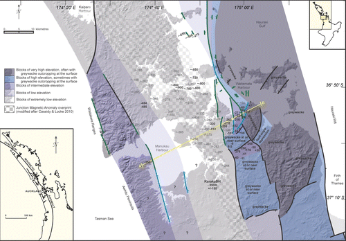
We note that the southern end of the western basement high is likely to be deepening considerably. About 1 km beyond the southern margin of the study area, basement was encountered at 843 m in Otaua-1 drillhole. Five kilometres further south, in the vicinity of Waikato North Head, gravity measurements indicate that basement is 2.7 km deep (Hochstein & Nunns Citation1976).
Implications for volcanism
The results of this study have significant implications for our understanding of the behaviour of volcanism in Auckland. On a regional scale, our block faulting model for Auckland provides further support for the connection between the Junction Magnetic Anomaly and Auckland volcanism, as suggested by Cassidy & Locke (Citation2010). The eastern and western boundaries of this major crustal feature may in fact constrain the location of the outer boundaries of the volcanic field, and the Dun Mountain–Maitai terrane rocks might provide a zone of weakness through which magma is able to ascend. This is consistent with the fact that there are no greywacke xenoliths in AVF juvenile material, but several occurrences of ultramafic enclaves likely to be associated with the Dun Mountain–Maitai Terrane.
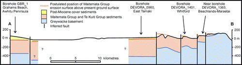
Figure 9 Simplified cross-section based on , oriented perpendicular to NNW-trending inferred faults. It shows differential offsets of the greywacke and Waitematā Group erosion surfaces. Remobilisation is evident from differences in offsets of these two surfaces on the NNW-trending faults. Boreholes close to the cross-section line are indicated.
The Waitematā Group erosion surface, although not exactly corresponding with pre-volcanic topography (in some cases AVF erupted onto Plio-Pleistocene sediments overlying Waitematā sediments), gives a very good indication of the topography of the area during past eruptions. It may therefore aid correlation of specific lava flows, now filling major fault-controlled valleys, with source volcanoes. For example, the proposal by Eade (Citation2009) that the Meola Reef lava flow was sourced from Mt St John rather than Mt Eden or Three Kings is supported by palaeotopography data from our study.
The identification of several new faults in the area covered by the AVF may mean that there is greater structural control on volcanism than was previously thought; it is useful to compare the distribution of vents with fault locations. Many attempts have been made to analyse patterns of vent alignments (e.g. Allen & Smith Citation1994; Magill et al. Citation2005; Von Veh & Nemeth Citation2009; Bebbington & Cronin Citation2011; Hayward et al. Citation2011) but no dominant trends are evident, which is unusual compared to similar overseas volcanic fields (e.g. Cassidy & Locke Citation2010).
Vents in the AVF do not seem to be exactly aligned with faults proposed in this study, although they are usually within 500 m of inferred faults. It is more likely that magma ascended up conduits in the basement then spread out along any plane of weakness it found within the overlying Waitematā Group strata, possibly preferring open joints rather than faults which tend to suture shut after faulting has ceased.
The actual placement of any vent would be a function of (1) the position of a spot along the basement fault at the basement/cover interface, somewhere above a source in the mantle, to where the magma ascends and (2) some vector from that spot in any number of ascending directions. Subtle alignments along basement fault zones are retained, but vents are not positioned directly along reactivated fault traces that offset the covering Waitematā Group erosion surface, favouring joints or other planes of weakness instead. It is likely that once magma has cooled and solidified within a conduit in the Waitematā Group rocks it effectively blocks that route, necessitating other pathways to be utilised by subsequent magma batches.
Conclusions
We have used an unconventional analysis that has involved mapping of apparent offsets of a sometimes concealed erosion surface to identify potential subsurface block faults transecting the Auckland region. Our main conclusions are as follows.
| • | The present-day erosion surface of the Waitematā Group exists at different elevations and we infer these variations to be due to uplift caused by block faulting. | ||||
| • | Sixty-four new faults have been inferred from a combination of attributes such as offsets of the Waitematā Group erosion surface, borehole and geophysical data, lineaments and continuation of known faults. They have been assigned a high-, moderate- or low-confidence rating based on their total attribute score. Seventeen new faults have a high rating, 33 are rated as moderate and 14 as low. | ||||
| • | Two significant fault sets are postulated; one dominantly trending NNW truncates the other trending approximately ENE. Although both sets have representative segments south of Auckland that may still be active, we believe that faults in the Auckland area are unlikely to be active as the only evidence of comparatively recent fault movement is at Beachlands dated at <340,000 BP. | ||||
| • | Volcanic ash has concealed much of the Waitematā Group erosion surface, but it is evident that lava flows have utilised long straight valley segments in that erosion surface. These valleys are mapped as lineaments representing eroded crush zones associated with faults separating the discordant blocks. | ||||
| • | Some block faulting may be aligned along reactivated NNW-trending faults within the basement. Basement greywacke outcrops only in the east of the region. Further west, borehole and geophysical evidence indicates that the buried basement surface deepens westwards along a series of NNW-trending faults. No boreholes have penetrated deep enough to encounter basement through the central Auckland region, but it rises again in the west to be 485 m below sea level under west Auckland and 340 m below sea level under northern Āwhitu Peninsula. | ||||
| • | It has been suggested in this study that there is no rational correlation of vent alignments in the AVF; however, most of the vents exposed in our mapped area are within 500 m of the newly inferred faults (). It has been suspected in the past by many researchers that rising magma has utilised basement faults. This would be logical, especially if it has penetrated through sheared Dun Mountain–Maitai terrane (which apparently occupies a widened zone in the Auckland region) rather than relatively intact greywacke. Magma rise may have been constrained eastwards and westwards by basement faults that coincide with the eastern and western margins of the widened JMA pod (Dun Mountai–Maitai terrane) beneath Auckland. | ||||
| • | It is conceivable, although highly speculative, that when magma reaches the top of the sheared Dun Mountain–Maitai terrane basement it encounters an obstruction of intact Waitematā Group sediments. It may then exploit joints or other planes of weakness, fanning outwards to reach the surface near faults but not necessarily exactly along them. | ||||
Acknowledgements
Many people have provided useful advice during this project, but we wish especially to thank Bruce Hayward, Graham Mansergh, Julie Rowland, Bernhard Spörli and Barry Waterhouse for spending many hours in lively discussions. We are also indebted to Steve Edbrooke for supplying maps and 1960s aerial photographs, Bernard Hegan for providing Vector tunnel borehole logs and maps, Bryan Davy for helping to decipher seismic profiles and Hugh Grenfell for assisting with map compilation and for reading and improving the manuscript. The study was supported by funding from the DEVORA and PETLAB projects. JML acknowledges support from EQC. Helpful and detailed comments by reviewers Dave Craw and Steve Edbrooke significantly improved the manuscript.
References
- Affleck , DK , Cassidy , J and Locke , CA . 2001 . Te Pouhawaiki Volcano and pre-volcanic topography in central Auckland: volcanological and hydrogeological implications . New Zealand Journal of Geology and Geophysics , 44 : 313 – 321 . doi: 10.1080/00288306.2001.9514940
- Allen , SR and Smith , IEM . 1994 . Eruption styles and volcanic hazard in Auckland Volcanic Field, New Zealand . Geoscience Reports of Shizuoka University , 20 : 5 – 14 .
- Ballance , PF . 1968 . The physiography of the Auckland District . New Zealand Geographer , 24 ( 1 ) : 23 – 49 .
- Ballance , PF . 1974 . An inter-arc flysch basin in northern New Zealand: Waitemata Group (upper Oligocene to lower Miocene) . Journal of Geology , 82 : 439 – 471 . doi: 10.1086/627993
- Ballance , PF and Spörli , KB . 1979 . Northland Allochthon . Journal of Royal Society of New Zealand , 9 ( 2 ) : 259 – 275 . doi: 10.1080/03036758.1979.10419416
- Ballance , PF and Schofield , JC . 1983 . Two-day excursion to the Waitemata and Waitakere Groups, November 12th & 13th, 1983 . Geological Society of New Zealand Miscellaneous Publication , 45 : 189 – 200 .
- Barter TP 1976 . The Kaihu group (Plio-Quaternary) of the Awhitu Peninsula, South-West Auckland . Unpublished PhD thesis , University of Auckland , Auckland .
- Bebbington , M and Cronin , SJ . 2011 . Spatio-temporal hazard estimation in the Auckland Volcanic Field, New Zealand, with a new event-order model . Bulletin of Volcanology , 73 ( 1 ) : 55 – 72 . doi: 10.1007/s00445-010-0403-6
- Berry KA 1986 . Stratigraphic, structural and geophysical studies of Neogene sediments of the Manukau Lowlands . Unpublished MSc thesis , University of Auckland , Auckland .
- Berryman KR 1984 . Late Quaternary tectonics in New Zealand . In : Walcott , R.I. compiler . An introduction to the recent crustal movements of New Zealand . Royal Society Miscellaneous Publication 7 : 91 – 107 .
- Beu , AG . 1974 . A Kaawa Creek molluscan fauna from a bore south of Manukau Harbour, Auckland . New Zealand Journal of Geology & Geophysics , 17 ( 2 ) : 490 – 494 . doi: 10.1080/00288306.1974.10430407
- Cassidy , J and Locke , CA . 2010 . The Auckland volcanic field, New Zealand: Geophysical evidence for structural and spatio-temporal relationships . Journal of Volcanology and Geothermal Research , 195 : 127 – 137 . doi: 10.1016/j.jvolgeores.2010.06.016
- Cassidy , J , Locke , CA and Smith , IEM . 1986 . Volcanic hazard in the Auckland region . New Zealand Geological Survey record , 10 : 60 – 64 .
- Claessens , L , Veldkamp , A , ten Broeke , EM and Vloemans , H . 2009 . A Quaternary uplift record for the Auckland region, North Island, New Zealand, based on marine and fluvial terraces . Global and Planetary Change , 68 : 383 – 394 . doi: 10.1016/j.gloplacha.2009.03.001
- Clark RH 1948 . Evolution of drainage of area between southern shores of Kaipara Harbour and Waitemata Harbour . Unpublished MSc thesis , University of Auckland , Auckland .
- Davy , B . 2008 . Marine seismic reflection profiles from the Waitemata-Whangaparoa region, Auckland . New Zealand Journal of Geology and Geophysics , 51 ( 3 ) : 161 – 173 . doi: 10.1080/00288300809509857
- De Lange , J and Lowe , DJ . 1990 . History of vertical displacement of Kerepehi Fault at Kopouatai bog, Hauraki Lowlands, New Zealand, since c. 10 700 years ago . New Zealand Journal of Geology and Geophysics , 33 : 277 – 283 . doi: 10.1080/00288306.1990.10425685
- Eade JE 2009 . Petrology and correlation of lava flows from the central part of the Auckland Volcanic Field . Unpublished MSc thesis , University of Auckland , Auckland .
- Eccles JD 2003 . Structural and tectonic implications of the JMA in the Auckland area . Unpublished MSc thesis , University of Auckland , Auckland .
- Eccles , JD , Cassidy , J , Locke , CA and Spörli , KB . 2005 . Aeromagnetic imaging of the Dun Mountain Ophiolite Belt in New Zealand: insight into the fine structure of a major SW Pacific terrane suture . Journal of the Geological Society of London , 162 : 723 – 735 . doi: 10.1144/0016-764904-060
- Edbrooke SW compiler 2001 . Geology of the Auckland area . 1:250 000 geological map 3. 1 sheet + 74p . Institute of Geological & Nuclear Sciences Limited . Lower Hutt , , New Zealand .
- Edbrooke , SW , Sykes , R and Pocknall , DT . 1994 . Geology of the Waikato Coal Measures, New Zealand . Institute of Geological and Nuclear Sciences Monograph , 6 : 53 – 101 .
- Edbrooke , SW , Crouch , EM , Morgans , HEG and Sykes , R . 1998 . Late Eocene–Oligocene Te Kuiti Group at Mount Roskill, Auckland, New Zealand . New Zealand Journal of Geology & Geophysics , 41 : 85 – 93 . doi: 10.1080/00288306.1998.9514792
- Glading AV 1987 . Aspects of the engineering and Quaternary geology , Whitford, Brookby, Beachlands, Auckland. Unpublished MSc thesis , University of Auckland , Auckland .
- Hayward BW 1975 . Lower Miocene geology of the Waitakere Hills , West Auckland, with emphasis on the paleontology. Unpublished PhD thesis , University of Auckland , Auckland .
- Hayward , BW . 1982 . A lobe of “Onerahi Allochthon” within Otaian Waitematas . Geological Society of New Zealand Newsletter , 58 : 13 – 19 .
- Hayward BW 1983 . Sheet Q11 Waitakere. Geological Map of New Zealand 1:50 000 . Map (1 sheet) and notes (28 p) . Wellington , , New Zealand . Department of Scientific and Industrial Research.
- Hayward BW 1993 . The tempestuous 10 million year life of a double arc and intra-arc basin New Zealand's Northland Basin in the Early Miocene . In : Ballance PF South Pacific Sedimentary Basins . Basins of the World 2 . Amsterdam , Elsevier . Pp. 113 – 142 .
- Hayward , BW . 2009 . “ Land, sea and sky ” . In West – The history of Waitakere , Edited by: MacDonald , F and Kerr , R . 7 – 22 . Auckland : Random House .
- Hayward BW , Grenfell HR 2010 . The Puketoka Formation and the age of the Hauraki Graben . In Eccles JD , Grigor MR , Hoskin PWO , Hikuroa DCH Field Trip Guides, GeoNZ 2010 Conference , Auckland , New Zealand . Geoscience Society of New Zealand Miscellaneous Publication 129B: http://www.gsnz.org.nz/pdf/MP129B_FT2.pdf (accessed 3 September 2012).
- Hayward BW , Brook FJ , Isaac MJ 1989 . Cretaceous to middle Tertiary stratigraphy, paleogeography and tectonic history of Northland, New Zealand . In : Spörli KB , Kear D Geology of Northland: accretion, allochthons and arcs at the edge of the New Zealand micro-continent . Royal Society of New Zealand Bulletin 26 : 47 – 64 .
- Hayward , BW , Murdoch , G and Maitland , G . 2011 . Volcanoes of Auckland: The Essential Guide , Auckland : Auckland University Press .
- High R 1975 . Aspects of upper Oligocene–Quaternary diastrophism in the Auckland Region (with special reference to the south Manukau area) . Unpublished paper presented at Geological Society of New Zealand conference , Kaikoura 1975 . 22 p.
- High R 1977 . Auckland Thermal No.1 Power Station , Waiau Pa. Underground water right application. Auckland Engineering Laboratory. AEL No.77/46 . 22 p.
- Hochstein , MP and Nunns , AG . 1976 . Gravity Measurements across the Waikato Fault, North Island, New Zealand . New Zealand Journal of Geology & Geophysics , 19 ( 3 ) : 347 – 358 .
- Hochstein , MP and Nixon , IM . 1979 . Geophysical study of the Hauraki Depression, North Island, New Zealand . New Zealand Journal of Geology and Geophysics , 22 : 1 – 19 . doi: 10.1080/00288306.1979.10422550
- Hochstein M.P , Tearney K , Rawson K , Davey FJ , Davidge S , Henrys S , Backshall D 1986 . Structure of the Hauraki Rift (New Zealand) . In : Reilly WI , Hurford BE Recent crustal movements of the Pacific region . Journal of the Royal Society of New Zealand Bulletin 24 : 333 – 348 .
- Howe T , Lindsay J , Mortimer N , Leonard G 2011 . DEVORA Borehole Database: Status Update and Manual . DEVORA Project. IESE Technical Report 1-2011.03 .
- Hull AG , Mansergh GD , Townsend TD , Stagpoole V 1995 . Earthquake hazards in the Auckland region . Client Report 33494D.10 . Institute of Geological and Nuclear Sciences Limited . 37 P.
- Isaac MJ , Herzer RH , Brook FJ , Hayward BW 1994 . Cretaceous and Cenozoic sedimentary basins of Northland, New Zealand . Institute of Geological and Nuclear Sciences Monograph 8. 203 p. and 4 sheets . Institute of Geological & Nuclear Sciences Limited . Lower Hutt , , New Zealand .
- Kamp , PJJ . 1986 . The mid-Cenozoic Challenger Rift System of western New Zealand and its implications for the age of Alpine fault inception . Geological Society of America Bulletin , 97 : 255 – 281 . doi: 10.1130/0016-7606(1986)97%3C255:TMCRSO%3E2.0.CO;2
- Kenny JA 2007 . JAFfA – Just Another Fault for Auckland – a preliminary investigation of block faulting . Geological Society of New Zealand Miscellaneous Publication 123A – conference abstract : p. 80 .
- Kenny , JA . 2008a . JAFfA Just Another Fault for Auckland: ongoing investigation of faulting in Auckland . Geological Society of New Zealand Newsletter , 145 : 3 – 11 .
- Kenny , JA . 2008b . Northland Allochthon-related slope failures within the Waitemata Group . Geocene , 3 : 5 – 7 .
- Kenny JA , Lindsay JM , Howe TM 2010 . Regional faulting in Auckland – a consequence of allochthon “nudging” and remobilised block faulting . In : Eccles JD , Grigor MR , Hosking PWO , Hikuroa DCH Abstract Volume, GeoNZ 2010 Conference, Auckland, New Zealand. Geoscience Society of New Zealand Miscellaneous Publication 129A : p. 154 .
- Kenny JA , Lindsay JM , Howe TM 2011 . Large-scale faulting in the Auckland region . Institute of Earth Science and Engineering (IESE) Technical Report 1-2011.04 .
- Kermode LO 1986 . Sheet N42/9 Whitford . Geological map of New Zealand (industrial series) 1:25 000 . Wellington , , New Zealand . Department of Scientific & Industrial Research .
- Kermode LO 1992 . Geology of the Auckland urban area . 1:50 000. Institute of Geological and Nuclear Sciences geological map 2. 1 sheet + 63p . Institute of Geological and Nuclear Sciences Ltd . Lower Hutt , , New Zealand .
- Lindsay , JM , Leonard , GS , Smid , ER and Hayward , BW . 2011 . Age of the Auckland Volcanic Field: a review of existing data . New Zealand Journal of Geology and Geophysics , 54 ( 4 ) : 379 – 401 . doi: 10.1080/00288306.2011.595805
- Magill , CR , McAneney , KJ and Smith , IEM . 2005 . Probabilistic assessment of vent locations for the next Auckland Volcanic Field event . Mathematical Geology , 37 ( 3 ) : 227 – 242 . doi: 10.1007/s11004-005-1556-2
- Milligan JA 1977 . A geophysical study of Rangitoto volcano. Auckland . Unpublished MSc thesis , University of Auckland , Auckland .
- Morris JC 1983 . The structural geology of the Waitemata Group at Musick Point, Auckland, New Zealand . Unpublished BSc (Hons) thesis , University of Auckland , Auckland .
- Murray RH 2010 . A geophysical investigation of volcanic deposits and paleotopography in the Auckland Isthmus . Unpublished MSc thesis , University of Auckland , Auckland .
- Reyners , M . 2011 . Lessons from the destructive Mw 6.3 Christchurch, New Zealand, Earthquake . Seismological Research Letters , 82 ( 3 ) : 371 – 372 . doi: 10.1785/gssrl.82.3.371
- Schofield JC 1979 . Parts sheets N38, N39, N42 and N43 Waiheke . Geological map of New Zealand 1:63 000 . Map (1 sheet) and notes (16p) . Wellington , , New Zealand . Department of Scientific & Industrial Research .
- Schofield JC 1989 . Sheets Q10 and R10, Helensville and Whangaparaoa , Geological map of New Zealand . 1:50 000. Map (2 sheets) and notes (43 p.) , Wellington , , New Zealand . Department of Scientific and Industrial Research .
- Searle , EJ . 1944 . Geology of the southern Waitakere hills region west of Auckland city . Transactions of the Royal Society of New Zealand , 74 : 49 – 70 .
- Sherburn , S , Scott , BJ , Olsen , J and Miller , CA . 2007 . Monitoring seismic precursors to an eruption from the Auckland Volcanic Field, New Zealand . New Zealand Journal of Geology & Geophysics , 50 : 1 – 11 . doi: 10.1080/00288300709509814
- Sivell , WJ and McCulloch , MT . 2000 . Reassessment of the origin of the Dun Mountain ophiolite, New Zealand: Nd-isotopic and geochemical evolution of magma suites . New Zealand Journal of Geology & Geophysics , 43 : 113 – 146 .
- Smith , IEM . 1989 . “ North Island ” . In Intraplate Volcanism in Australasia , Edited by: Johnson , RW . 157 – 162 . Cambridge University Press. .
- Spörli , KB . 1982 . Review of the paleostrain/stress directions in Northland, New Zealand, and of the structure of the Northland Allochthon . Tectonophysics , 87 : 25 – 36 . doi: 10.1016/0040-1951(82)90219-0
- Spörli KB 1989 . Exceptional structural complexity in turbidite deposits of the piggy-back Waitemata Basin, Miocene, Auckland/Northland, New Zealand . In : Spörli KB , Kear D Geology of Northland: accretion, allochthons and arcs at the edge of the New Zealand micro-continent . Royal Society of New Zealand Bulletin 26 . Pp. 183 – 194 .
- Spörli , KB and Rowland , JV . 2007 . Superimposed deformation in turbidites and syn-sedimentary slides of the tectonically active Miocene Waitemata Basin, northern New Zealand . Basin Research , 19 ( 2 ) : 199 – 216 . doi: 10.1111/j.1365-2117.2007.00320.x
- Spörli KB , Stanaway 2007 . High shore platforms in the Hauraki Gulf , Auckland: due to sea level changes or tectonics? Geological Society of New Zealand Newsletter 144 : 3 – 7 .
- Stagpoole VM 1997 . A geophysical study of the northern Taranaki Basin, New Zealand . Unpublished PhD thesis , Victoria University of Wellington , Wellington .
- Stirling , MW , McVerry , GH and Berryman , KR . 2002 . A new seismic hazard model for New Zealand . Bulletin of the Seismological Society of America , 92 ( 5 ) : 1878 – 1903 . doi: 10.1785/0120010156
- Tejaksuma IG 1998 . Slope movement and faulting in Quaternary deposits and Miocene weak rock at Beachlands, Auckland, New Zealand . Unpublished MSc thesis , University of Auckland , Auckland .
- Turner , RJ and Bartrum , JA . 1929 . The geology of the Takapuna Silverdale District, Waitemata County, Auckland . Transactions of the New Zealand Institute , 59 ( 4 ) : 864 – 902 .
- Von Veh , MW and Nemeth , K . 2009 . An assessment of the alignments of vents based on geostatistical analysis in the Auckland Volcanic Field, New Zealand. Géomorphologie: Relief, Processus . Environnement , 3 : 175 – 186 .
- Waterhouse , BC . 1989 . Greywacke in west Auckland – never . Geological Society of New Zealand Newsletter , 84 : 71
- Williams HA 2003 . Geophysical and structural investigation of basement greywacke in the Auckland region, University of Auckland . Unpublished MSc thesis , University of Auckland , Auckland .
- Williams , HA , Cassidy , J , Locke , CA and Spörli , KB . 2006 . Delineation of a large ultramafic massif embedded within a major SW Pacific suture using gravity methods . Tectonophysics , 424 ( 12 ) : 119 – 133 . doi: 10.1016/j.tecto.2006.07.009
- Wise DJ 1999 . Geophysical and geotechnical study of the Wairoa North Fault, South Auckland . Unpublished MSc thesis , University of Auckland , Auckland .
- Woollaston M 1996 . The Junction Magnetic Anomaly in the Auckland region . Unpublished BSc (Hons) thesis , University of Auckland , Auckland .