Abstract
In 1994 the QMAP 1:250 000 Geological Map of New Zealand project began with compilation of the Dunedin sheet. Nearly 18 years later, publication of the Hawke's Bay sheet marks the completion of all 21 maps. The adoption of geographic information systems (GIS) software for data capture, data management and map production has not only produced high cartographic quality maps, but also built the attribute-rich, nationally consistent QMAP GIS spatial database. The project cost about NZD $24M, and the results are now being used by government, industry and research organisations across infrastructure, geological hazard, resource and environmental areas. QMAP has added significantly to general knowledge of New Zealand's geological composition and history due to new discoveries and validation of concepts. Notable advances include work on the allochthons of Northland and East Coast; rationalisation of the Taupo Volcanic Zone and East Coast stratigraphic successions; differentiation of the Torlesse basement terranes; clarification of the transition from Otago Schist to Alpine Schist; determining the complex spatial and temporal history of igneous intrusions in Fiordland and Stewart Island; and mapping Quaternary sediments by oxygen isotope stage and depositional processes.
Introduction
Geological maps provide fundamental information on the spatial and temporal association of rock types, faults and many other geological features. Information contained within a geological map is an interpreted summary of knowledge available at the time of compilation. As new information becomes available, maps become dated; in addition, in the last 50 years the concepts of plate tectonics, terrane accretion and sequence stratigraphy have developed and matured. These concepts have changed the way rocks are classified, associated and interpreted. Furthermore, the ways in which society uses geological information have evolved and expanded. In response to this, geological surveys around the world have undertaken new editions of older map series and produced new series at larger, more detailed scales.
Geological maps have been compiled in New Zealand for more than 150 years, mostly by the New Zealand Geological Survey and its successor GNS Science, a government-owned Crown Research Institute. Systematic ‘campaign’ geological mapping began in 1905 after James McIntosh Bell was appointed Director. Published geological bulletins were accompanied by printed maps at a scale of 1:63 360 and, where warranted, larger scales. Only a third of the country had been covered by 1956, prompting Dick Willett (the then Director) to launch a 1:250 000 Geological Map of New Zealand project. Twenty-eight maps with accompanying notes were printed between March 1959 and January 1968. Informally known as the ‘4 Mile’ (4 miles to the inch) maps, the series was a triumph in that it achieved a standardised, up-to-date, regional-scale depiction of New Zealand geology.
The QMAP project
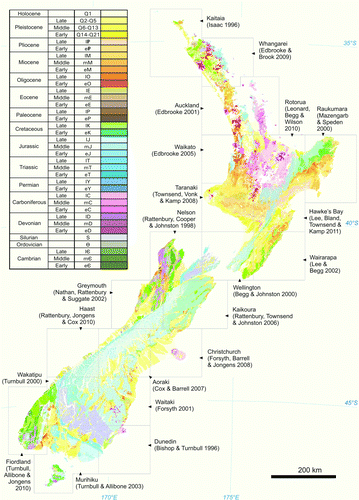
A revision of the 1:250 000 geological map was announced in 1982 and an initial trial map was prepared, but the project stalled and no maps were published. In February 1992 a government-instigated review of science in New Zealand stated ‘Revised geological mapping at a scale of 1:250 000 is urgently required’ (MoRST Citation1993), and a subsequent bid for funding from the Foundation for Research, Science and Technology (FRST) to support a national mapping project was successful. That prompted a discussion paper explaining the concept and outlining the scope of a new 1:250 000 geological map series to be completed within a project named QMAP (Quarter-million MAP; Nathan Citation1993). New Zealand was subdivided into 21 areas () and a campaign-style approach planned, involving compilation of existing information and field work in poorly known areas. The QMAP project began in 1994 with compilation of the Dunedin sheet (Bishop & Turnbull Citation1996) and concluded with the publication of the Hawke's Bay sheet (Lee et al. 2011). For QMAP the key elements for success were the supportive funding agency, broad support from the wider geoscience community, a wealth of data to absorb including unpublished reports and theses, versatile and effective geographic information systems (GIS) technology and a team of experienced people who were determined to finish the job. The project cost about NZD $24M (see Appendix) and the maps are used by government, industry, consultants, researchers, educators and the public in areas such as infrastructure planning, geological hazard awareness and mitigation, resource discovery and management and environmental assessment.
Figure 1 The QMAP 1:250 000 Geological Map of New Zealand. Units are coloured by age except for Neogene and Quaternary volcanic rock units. The key is the original colour-age scheme proposed by Miles Reay in the early stages and generally followed.
Mapping philosophy
Geological maps typically depict units in terms of lithostratigraphy or chronostratigraphy; QMAP adopted a pragmatic mixture of both. QMAP endeavoured to use existing stratigraphic units but where new units were identified they were formalised in journal publications (e.g. Allibone & Tulloch Citation2004; Allibone et al. Citation2007). Elsewhere, new mapping resulted in stratigraphic simplification (e.g. Mazengarb & Speden Citation2000).
Lithostratigraphic units were coloured according to age of deposition or emplacement () and international timescale units were favoured over local stage names. The Quaternary period was retained and subdivided using oxygen isotope stages. Neogene and Quaternary volcanoes that preserve much of their original geomorphologic form were shown in red hues. Map unit labels, typically 2 or 3 characters, contain an age component and a stratigraphic and/or lithology component; for example, ‘Tmg’ is the Triassic Maitai Group Greville Formation and ‘Q2t’ is a Quaternary (oxygen isotope stage 2) till.
QMAP is a collection of conventional composite geological maps, intended for a wide audience, with even treatment of older and younger rock units. The emphasis has been on deposits rather than landforms. As a general rule, the uppermost deposit or rock unit more than 5 m thick has been depicted, hence veneers of soils, tephra, loess and scree are commonly omitted. Establishing how thin these veneer deposits are can be difficult and their depiction on the map is commonly in the absence of nearby evidence for underlying rock. The end result is composite mapping units defined by one or more of age, lithostratigraphy, lithology, geochemical affinity (for plutons) and metamorphic grade. Metamorphic rock units are portrayed in terms of their known or inferred protolith age; Haast Schist rocks have overprints depicting their textural metamorphic grade. The geological legends differ from established practice where units are commonly restricted to a single hierarchical column. QMAP extended the ‘fat legend’ concept developed for 1:50 000 geological maps in the 1980s (e.g. Johnston Citation1981) because of the difficulty in portraying basement terranes that overlap in time within a single column. For example, the Nelson QMAP includes seven terranes and two batholiths, four of which have Triassic units (Rattenbury et al. Citation1998). The broadly west–east geographical separation of New Zealand basement terranes and batholiths has been replicated on the map legends, from left to right. Similarly, the spatial distribution of Late Cretaceous–Cenozoic sedimentary rocks has been shown using the fat legend concept. The resulting legends are complex but place rock units in both a spatial and temporal context; some legends take up more space than their associated map.
Map compilation
QMAP relied heavily on existing knowledge. The first task for all maps was to discover and assemble previous work and to assess each data source for quality. Knowledge gaps and areas of conflicting interpretations were then targeted for field work.
The 1:50 000 NZMS260 topographic map series, produced by the Department of Survey and Land Information, provided a superb set of base maps at a scale ideal for geological compilation. Contours, rivers, streams, lakes, coast and roads were available in affordable digital formats after 1999. A data source map was prepared for each 1:50 000 sheet by plotting the areal extent of each source used. The original maps were enlarged or reduced to 1:50 000 to facilitate manual drawing of geological boundaries and other features on to record sheets using light tables in as much detail as the scale allowed. Simplified compilation sheets were redrawn from these to achieve a level of complexity appropriate for portrayal in a 1:250 000 map.
Map production and data management
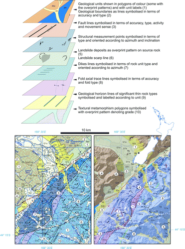
Early adoption of GIS software for cartographic and pre-press map production in-house was a pivotal decision. In the early 1990s GIS was mainly used for the acquisition, management and analysis of digital spatial data and there was uncertainty about whether it could create high-quality colour separates for lithoprinting. The ESRI® software ArcInfo® was selected for its functionality and versatility; only just affordable in 1994, it did all that was required and endured for the length of the project with no show-stopping upgrades. Procedures were developed to capture, manage and plot GIS data through computer scripting (Rattenbury et al. Citation1994; Heron et al. Citation1997; Rattenbury & Heron Citation1997) and the software enabled considerable experimentation with colour, patterns, map design and legend form. The major strength of the GIS software is its spatial database capability for organising and attaching information (attributes) to geometrical representations of geological features in thematic layers (). Geological units are represented as polygons with attributes describing, for example, stratigraphic affiliation, rock type and emplacement age. Faults are represented by line features with attributes describing accuracy, type, orientation, name and age, magnitude and sense of movement. Structural measurements are point features with attributes describing, for example, the type of structure and its orientation. The geometrical features were digitally captured using large-format digitiser boards and linked to spreadsheets of attribute data. A pragmatic balance was struck between attribute richness (providing information about geological features) and technical complexity (e.g. avoiding table links and interdependencies). The information stored against the features was compiled principally for the digital GIS dataset products rather than what was needed for the printed maps. Attribute values are stored in a single table for each layer and directly linked to the geometry of each feature. Increased processing overheads and data redundancy are inevitable with such an approach, but it avoided the complexity of inter-linking multiple tables and reduced the need for specialist relational database expertise.
Figure 2 The QMAP GIS is a collection of digital layers, including features such as geological units, faults, landslides and structural measurements. Numbered examples of these are identified in the maps below. The layers are combined using GIS software to produce the printed map (left, from Haast QMAP, Rattenbury et al. Citation2010) or its equivalent viewed on-screen (right). Other standard layers in the QMAP GIS not shown here include metamorphic mineral zones, veins and data sources.
Text production
Each QMAP is accompanied by a well-illustrated full-colour book summarising the geology. Mapping units are described in some detail and there are summaries of regional geomorphology, tectonic history, engineering geology, geological hazards and geological resources. Texts became more elaborate as the series progressed, and some proved to be almost as demanding as production of the geological map. Each map and text was subject to rigorous peer review within GNS Science and from New Zealand consultants and university staff, and was carefully prepared for publication to meet the high standard set by the series editor. More than 14,700 of the texts with accompanying maps have been sold in printed hardcopy and digital formats (see Appendix) and they are being reprinted as stocks run low.
Scientific advances
Geological mapping involves observation and interpretation of rocks in both easily accessible and remote places. Some areas had never been visited by geologists previously and there was ample opportunity for new discovery. QMAP provided insights into the geology of New Zealand and the ground truth for concepts.
The Northland and East Coast allochthons
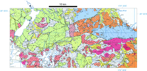
The North Cape, Whangarei and Auckland 4-mile geological maps of the 1960s showed isolated, small areas of ‘Onerahi Formation’ emplaced over younger strata, but these maps and the East Cape sheet predated recognition of the widespread overthrust and imbricated nature of much of the Cretaceous and Palaeogene strata (Stoneley Citation1968; Ballance & Sporli Citation1979). The Kaitaia, Whangarei, Auckland and Raukumara QMAPs portray the extents of the Northland and East Coast allochthons and show that, on a regional scale, they can be resolved into mappable sub-units based on age and lithology (; Isaac Citation1996; Mazengarb & Speden Citation2000; Edbrooke Citation2001; Edbrooke & Brook Citation2009). Diagonal white striping superimposed on the protolith body colour of allochthonous units provides a unifying identity. The Northland Allochthon has some of its oldest units, including the Tangihua Complex of submarine basaltic pillow lava and gabbro, structurally high in the thrust succession, overlying younger, more proximal, clastic and calcareous sedimentary rocks. Near the southern margin, the increasingly dissociated rocks comprise melange enclosing large, more coherent blocks; the melange is thrust over autochthonous Early Miocene Waitemata Group and is unconformably overlain by higher Waitemata Group formations (). The previously published QMAP Auckland map had resolved mixed lithology units into undifferentiated Mangakahia and undifferentiated Motatau complexes; field mapping for QMAP Whangarei however showed this was not always feasible and that melange should be mapped as a discrete unit, an example of how interpretation has evolved even within the QMAP project time frame.
Figure 3 An area of southern Northland showing geological units of the Northland Allochthon with diagonal white striping, in contrast to autochthonous units in the east (Whangarei QMAP, Edbrooke & Brook Citation2009). Low-angle thrusts within the allochthon have juxtaposed older rocks upon younger and the displaced Cretaceous, Palaeogene and Miocene strata become increasingly dissociated to the south, passing into a sequence dominated by melange (shown here in grey).
Taupo Volcanic Zone
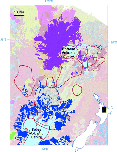
The diverse products of volcanism in the Taupo Volcanic Zone include high-level intrusives, lavas, pyroclastic flow deposits, proximal and distal tephras and fluvially reworked material. The compositional variation spans rhyolitic, andesitic and basaltic rocks, erupted intermittently over 2 million years. QMAP developed a stratigraphic map unit approach which grouped eruptives emanating from one source over a discrete time interval (Wilson Citation2002; Edbrooke Citation2005; Townsend et al. Citation2008; Leonard et al. Citation2010; Lee et al. Citation2011). For example, the Oruanui Formation () incorporates ignimbrite and numerous named ash and tephra deposits that erupted from the Taupō caldera around 27 ka. This approach was made possible through the acquisition of a large number of radiometric dates together with detailed volcanic stratigraphy, petrography and geochemistry. Rhyolitic ignimbrites originating from at least eight calderas during a period of intense explosive volcanism in the Middle Quaternary dominate the area around Taupō and Rotorua (Leonard et al. Citation2010). Later rhyolite and dacite lava domes and dome complexes with well-preserved volcanic form are concentrated north of Lake Taupō and east of Lake Rotorua. The mapping philosophy of depicting the uppermost deposit or rock unit more than 5 m thick means tephra layers thinner than this are not shown. These thinner tephra deposits nevertheless record very large past eruptions which have impacted on much larger areas of the country than that indicated by the QMAPs.
Figure 4 The mapped extent of thick deposits of the Mamaku Plateau Formation (magenta) that erupted from the Rotorua Volcanic Centre at c. 240 ka and that of the widespread c. 27 ka Oruanui Formation (blue) erupted from the Taupo Volcanic Centre, are highlighted from the Rotorua QMAP GIS data (after Leonard et al. Citation2010).
East Coast stratigraphy
Detailed local studies of relatively small areas by many different authors had in the past resulted in many stratigraphic names for Neogene and, to a lesser extent, Palaeogene units east of the axial ranges and north of the Chatham Rise. The regional approach taken by QMAP emphasised similarities rather than local differences to create a simplified stratigraphy from which the history of this active margin can be more readily inferred (Mazengarb & Speden Citation2000; Lee & Begg Citation2002; Lee et al. Citation2011). The regional significance of several unconformities and the changes in facies led to a simple high-level subdivision of the rocks which post-date propagation of the active plate boundary in latest Oligocene to earliest Miocene time, best shown on QMAP Hawke's Bay and QMAP Raukumara. The subdivision can be applied retrospectively to QMAPs Wairarapa and Wellington. QMAP also rationalised the stratigraphic nomenclature applied to the Cretaceous, Palaeogene and Neogene units of Canterbury, Otago and eastern Southland (Bishop & Turnbull Citation1996; Forsyth Citation2001; Cox & Barrell Citation2007; Forsyth et al. Citation2008).
Active faults
QMAP compilation involved detailed aerial photo interpretation of landforms, particularly for mapping the extent of Quaternary deposits. Through this process, many new active faults were identified and more were discovered during field work. Examples include those on the flanks of Mt Taranaki (Townsend et al. Citation2008), in north Canterbury (Rattenbury et al. Citation2006) and in Southland (Turnbull & Allibone Citation2003). The general QMAP approach to active fault portrayal was to extrapolate and interpolate between known active traces, consistent with the observation that faults which rupture to the surface typically propagate over many kilometres. The QMAP active faults data subset has additional value in that it has been consistently acquired and is therefore relatively representative of the density and distribution of active faulting through New Zealand. The greater density of active faulting in the Rotorua area is particularly striking. Many more active faults have been identified from this area through very detailed mapping, but the limitations of the publication scale have allowed only a subset to be represented.
Quaternary
QMAP used the marine oxygen isotope stage (OIS) classification (Martinson et al. Citation1987) to differentiate Quaternary deposits by age. Deposits were divided where possible into interglacial deposits denoted with odd numbers, Q1 representing the youngest (Holocene), and glacial deposits denoted with even numbers. Less specific late, middle, early and undifferentiated Quaternary age ranges were used where age control was poorly constrained. Deposits were further divided in terms of constituent materials and depositional process, that is, alluvial, fan, scree, glacial till, beach, dune, landslide and swamp (). As a general rule, formal stratigraphic names have not been used in contrast to previous maps. Advances in relative and absolute dating of Quaternary deposits have allowed greater confidence in correlating between glacial and river catchments and the resulting QMAP depiction is more of a whole-of-system approach to the climatically driven Quaternary depositional processes. The QMAP approach laid the spatial foundations for improved understanding of the dynamics of Quaternary glacier systems and the accompanying changes in sea level (e.g. Barrell et al. Citation2011).
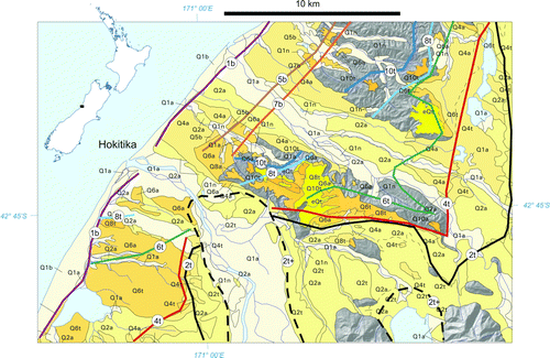
Figure 5 Quaternary alluvial, glacial and marine deposits in central Westland emphasised from the Greymouth QMAP GIS data. The unit labels beginning Q1, Q2, Q4 etc. refer to deposits of that oxygen isotope stage (OIS) age range. The last letter refers to the deposit type e.g. ‘a’ for alluvial; ‘t’ for till; and ‘b’ for beach. These Quaternary map units record the changing shoreline positions and ice limits between glacial and interglacial periods (interpretation modified after Nathan et al. Citation2002).
New Zealand's dominant rocks
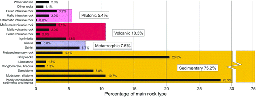
The influence of plate boundaries in New Zealand's geological history is reflected in the large proportion of clastic sedimentary deposits, many eroded from subduction-related igneous rocks or reworked from older sedimentary rocks. The proportion of various rock types at New Zealand's land surface was quantified approximately by Lauder (Citation1962) but the GIS underpinning QMAP enables the proportions to be calculated more precisely (). The proportions are biased towards basement rocks since QMAP did not map thin veneers of surficial deposits. Semantic indecision around using the term ‘sandstone’ rather than ‘greywacke’ in the middle stages of the QMAP project resulted in some inconsistency in rock name usage between the maps’ digital data. These inconsistencies were compensated for by Tenzer et al. (Citation2011) who used greywacke as a general term encompassing older, more lithified and weakly metamorphosed sandstone-dominated basement terranes, but including also lithified mudstone, conglomerate and other minor rock types. By this definition greywacke forms 20.5% of New Zealand's surface rock, eclipsed only by unconsolidated sediment and tephra (28.3%). Combined with other, mostly younger, sedimentary rock and most of the mapped schist component, more than 80% of the rocks and deposits at New Zealand's surface are sedimentary in origin.
Figure 6 Percentage land area of dominant rock types based on the QMAP GIS digital database MAIN_ROCK attribute. Note that there is a bias, since QMAP does not map thin veneers of sediment and tuff.
Greywacke geology
Late Palaeozoic and Mesozoic greywacke basement rocks of the Eastern Province make up about 21% of New Zealand's land area (; Tenzer et al. 2011). Many of these rocks belong to the Torlesse composite terrane, a unit that is difficult to subdivide using conventional lithostratigraphy. A QMAP workshop noted the paucity of fossils, the complex structure and monotonous lithofacies, and recommended differentiation of large-scale structurally coherent blocks and the use of form lines to depict structural trends (Cox & Begg Citation1999). The Kaikoura, Greymouth, Aoraki/Mt Cook and Christchurch QMAPs show form lines in lowest textural zone (I) Torlesse rocks, emphasising contrasting bedding trends in structural blocks. An example is the northeast-striking block in the Lowry Peaks Range of north Canterbury, which contrasts with the surrounding north- to northwest-striking ranges (Rattenbury et al. Citation2006). QMAP has delineated, where possible, key marker units such as volcanic layers and melange belts. Single Torlesse sedimentary horizons are rarely traceable over more than 10 km due to complex structural deformation. A semi-continuous deformed volcanogenic unit of green and red mudstone and basalt has been mapped for over 150 km between the Taramakau and upper Wairau rivers, and provides oblique piercing points for constraining Hope, Clarence and Awatere fault displacements (Nathan et al. Citation2002; Rattenbury et al. Citation2006). Lateral continuity of the Esk Head Belt between the South Island and Wellington has been established (Begg & Johnston Citation2000; Lee & Begg Citation2002; Nathan et al. Citation2002; Rattenbury et al. Citation2006; Forsyth et al. Citation2008) as well as further continuity, now locally excised by faulting, with the Pohangina and Whakatane melanges in the central North island (Leonard et al. Citation2010; Lee et al. Citation2011).
The QMAP differentiation and subdivision of the Torlesse was greatly helped by geochronology of detrital zircons from sandstones, funded through a complementary research programme which studied the rocks of New Zealand's continental crust (e.g. Adams et al. Citation2007, Citation2011). Recognition of the mainly Jurassic Kaweka terrane, west of the Esk Head Belt and Whakatane Melange, is a significant discovery. The advances in Torlesse geology were made incrementally as QMAP and the continental crust programme research proceeded. Inconsistencies which have emerged as QMAP progressed (such as the subdivision of the Pahau terrane, status of the Waipapa terrane and age of the Caples terrane) will be addressed in the ‘seamless QMAP’ digital database and a summary 1:1 M geology map to be completed early in 2013.
Schist geology
The schist and semischist rocks of Otago and the Southern Alps have been subdivided on the basis of textural metamorphic grade, protolith terrane and predominant lithology. Mineral metamorphic grade changes are indicated by the presence or absence of key minerals or mineral assemblages but textural metamorphic zones, a semi-quantitative measure of the degree of cleavage, foliation and metamorphic segregation development, are considerably easier to apply and map in the field. Field-based textural metamorphic grade criteria were developed by Bishop (Citation1974) and improved upon by Turnbull et al. (Citation2001) and applied to the Otago and Alpine schists. The complex greywacke-schist transition in the Southern Alps, north Otago and south Otago has also been mapped using textural zones (Turnbull Citation2000; Forsyth Citation2001; Cox & Barrell Citation2007; Rattenbury et al. Citation2010). Textural zone contrasts highlight major fault boundaries, for example, the Waihemo Fault in North Otago (Forsyth Citation2001) and the Main Divide Fault east of Aoraki/Mt Cook (Cox & Barrell Citation2007). The faults identified through textural zone mapping and bedding trends in greywacke have been used to understand the consequences of tectonic plate collision through the South Island (Cox & Sutherland Citation2007) and constrained interpretation of crustal-scale geophysics (Long et al. Citation2003).
The boundary between the Caples and Torlesse terranes through north and west Otago is heavily masked by Otago Schist high-grade textural metamorphic reconstitution across a complexly folded, ductile shear zone. The terrane affiliations of the schist rocks have been determined using petrographic, geochemical and geochronological methods. In northwest Otago, the Aspiring lithological association is the most prominent of some lithologically distinct areas of schist. The Aspiring lithological association is notable in that a large proportion has a mudstone protolith, with numerous metavolcanic or greenschist horizons. The structural and metamorphic transition between the Otago Schist in western Otago and Alpine Schist of the Southern Alps has been mapped through the Haast area (Turnbull Citation2000; Cox & Barrell Citation2007; Rattenbury et al. Citation2010). The Otago Schist attained peak metamorphic grade in Jurassic time and much of the structural deformation occurred during the Cretaceous. Alpine Schist has an additional younger metamorphism phase, with further deformation resulting from movement at the Australia–Pacific plate boundary. Mapping of textural metamorphic zones using revised criteria (Turnbull et al. Citation2001) and broad lithological associations of pelitic and psammitic greyschist and greenschist have revealed complex interactions of Mesozoic and Cenozoic structures and metamorphic fabrics. Through the Haast area, old fold structures tighten to the north and new foliation fabrics become more pervasive. The textural and mineral metamorphic zones and the extent of the Aspiring lithological association also narrow to the north.
Early Palaeozoic geology
Cambrian igneous and volcaniclastic sedimentary rocks in northwest Nelson, near Springs Junction and in southern Fiordland are the oldest rocks in New Zealand. These volcanogenic rocks formed in an Early Palaeozoic subduction setting and constitute the older part of the Takaka Terrane. Extensive faulting has further complicated laterally discontinuous volcanic rock facies. Aided by detailed petrology, geochemistry and geochronology, the older Takaka Terrane has been mapped as a series of fault blocks, each with a distinctive stratigraphy (Münker & Cooper Citation1995; Rattenbury et al. Citation1998). The younger part of the Takaka Terrane, spanning Ordovician–Early Devonian, is a passive margin succession of siliceous and calcareous sedimentary rocks. West of the Takaka Terrane, the Buller Terrane (extending from northwest Nelson, through the West Coast to Milford Sound and reappearing south of the Alpine Fault in Preservation Inlet) consists of the Ordovician quartzose sedimentary Greenland Group. The paragneisses of northern and central Westland are interpreted to be their high-grade metamorphic equivalent.
Plutonic and metamorphic geology of southern New Zealand
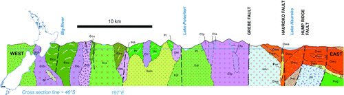
The original 4-mile mapping of Fiordland and Stewart Island was severely constrained by the difficult terrain, pressure to complete the maps, the lack of geochronology and the limited budget. Only small areas were traversed and the maps relied heavily on interpolation and extrapolation. For QMAP, Stewart Island established the pluton mapping approach that was used for Fiordland (Turnbull & Allibone Citation2003; Turnbull et al. Citation2010); both presented major challenges given the rugged terrain and testing climate. Fiordland was mapped in detail over six field seasons with comparatively generous budgets allowing much helicopter support. The field mapping was complemented by many radiometric dates and by geochemical and petrographic analyses, supplied partly by the complementary research programme on New Zealand's continental crust and partly through collaborations with overseas universities. A complex history of pluton intrusion and metamorphism has been determined (; e.g. Allibone & Tulloch Citation2004; Allibone et al. Citation2009a, Citationb). New Zealand's oldest plutons (latest Cambrian–earliest Ordovician) intrude Takaka Terrane in southern Fiordland (Allibone et al. Citation2009a).
Figure 7 East–west cross-section through southern Fiordland (after Turnbull et al. Citation2010) highlighting the extent to which Median Batholith Cretaceous and Jurassic granitic plutons (mid-light greens and pale blues) have intruded Middle Paloeozoic plutons (pinks) and Early Palaeozoic metasedimentary and meta-igneous gneisses (dark-olive greens). Oligocene and Miocene sedimentary rocks (orange colour) overlie Palaeozoic and Mesozoic basement in the east (Waiau Basin).
The Western Fiordland Orthogneiss has been subdivided into seven major dioritic and monzodioritic plutons. The rocks record the huge magmatic heat flux when this part of the Gondwana margin was in a convergent-transpressional subduction setting between Late Devonian and Early Carboniferous time, with renewed activity from Late Triassic time to the Middle Cretaceous. The Median Batholith concept that encompasses the numerous plutons that lie between and stitch New Zealand's Western and Eastern provinces (Mortimer et al. Citation1999) was adopted. A distinction was made between ‘inboard’ plutons, intruding Early Palaeozoic metasedimentary rock, and ‘outboard’ plutons forming along the suture zone between the Western and Eastern provinces. The suture zone is marked by a major shear zone in places: the Gutter Shear Zone in Stewart Island (Allibone & Tulloch Citation2008) and the Grebe Mylonite Zone in eastern Fiordland (Allibone et al. Citation2009a). Collectively, the Median Batholith intrudes both Western Province and the Brook Street Terrane of the Eastern Province (Turnbull et al. Citation2010). The Breaksea Gneiss, part of the Western Fiordland Orthogneiss composite pluton, has ecologitic assemblages that record New Zealand's highest known metamorphism and indicate pressure and temperature of 18 kbar and 850°C, respectively.
Early Cretaceous magmatism
In addition to the Early Cretaceous magma flux and widespread thermal metamorphism in southern New Zealand, the geological maps covering Westland and northwest Nelson also show the extent of significant pluton intrusion at this time. Much of this was associated with Median Batholith emplacement between the Western and Eastern provinces. In the Paparoa Range, Early Cretaceous intrusions are related to major extensional tectonics associated with development of a metamorphic core complex (Tulloch & Kimbrough Citation1989), the precursor to opening of the Tasman Sea in the Late Cretaceous.
Future directions
Geological maps are products of their time and they record available data, current interpretation and existing concepts. Geological maps do go out of date however; this is graphically illustrated by the 30 km surface rupture of the Greendale Fault (Quigley et al. Citation2012) during the Darfield earthquake of 4 September 2010, which post-dated publication of the Christchurch QMAP (Forsyth et al. Citation2008). The intention is to accommodate recent and future changes; digital versions of the 21 individual QMAPs have been stitched into a single QMAP Seamless GIS database. Earlier maps have been updated to fit with later maps, which incorporated more and better information. The QMAP Seamless GIS is available in digital formats only and it will be upgraded periodically. A new 1:1 million Geological Map of New Zealand (1:1M GMNZ) is being compiled from QMAP and will be available early in 2013. The digital version of the first edition 1:1M GMNZ, currently being served by GNS Science to the OneGeology international geological map portal (http://portal.onegeology.org), will be replaced by the new map.
A conventional, composite geological map such as QMAP is essentially a two-dimensional representation of the surface geology; understanding and modelling subsurface variation from such a map is difficult, particularly at a large scale. New geological map projects at larger (more detailed) scales will include three-dimensional geological models as part of the suite of map products. The emphasis will be on urban geology (e.g. ground-shaking hazard and liquefaction potential) and on areas with resource potential (e.g. minerals and geothermal heat).
Acknowledgements
Major contributors to QMAP have been the compilers Andrew Allibone, David Barrell, John Begg, Graham Bishop, Kyle Bland, Fred Brook, Roger Cooper, Simon Cox, Steve Edbrooke, Jane Forsyth, Mike Isaac, Mike Johnston, Richard Jongens, Peter Kamp, Julie Lee, Graham Leonard, Colin Mazengarb, Simon Nathan, Mark Rattenbury, Ian Speden, Pat Suggate, Dougal Townsend, Ian Turnbull, Adam Vonk and Colin Wilson, with significant compilation input from Greg Browne, Phil Glassey, Geoff Rait and Mike Rosenberg. Crustal basement work by Nick Mortimer, Andy Tulloch, Hamish Campbell and Chris Adams was an important contribution. Text production, GIS and cartography were provided by Philip Carthew, Greg Drummond, David Heron, Biljana Lukovic, Jeff Lyall, Ben Morrison, Penny Murray and Belinda Smith Lyttle; Lloyd Homer provided many of the photographs. The series editor was Jane Forsyth. New Zealand universities generously allowed access to thesis and other unpublished maps and NIWA supplied offshore data. Many internal and external reviewers improved the maps and books. QMAP was funded through Foundation for Research, Science and Technology contracts (C05303, C05X0003, C05X0401) and, latterly, direct Crown funding to GNS Science. Reviews by John Begg, Steve Edbrooke, Carol Evenchick, Adrian Pittari and Bernhard Spörli resulted in improvements to this paper.
References
- Adams , CJ , Campbell , HJ and Griffin , WL . 2007 . Provenance comparisons of Permian to Jurassic tectonostratigraphic terranes in New Zealand: perspectives from detrital zircon age patterns . Geological Magazine , 144 : 701 – 729 . doi: 10.1017/S0016756807003469
- Adams , CJ , Mortimer , N , Campbell , HJ and Griffin , WL . 2011 . Recognition of the Kaweka Terrane in northern South Island, New Zealand: preliminary evidence from Rb-Sr metamorphic and U-Pb detrital zircon ages . New Zealand Journal of Geology and Geophysics , 54 : 291 – 309 . doi: 10.1080/00288306.2011.569728
- Allibone , AH and Tulloch , AJ . 2004 . Geology of the plutonic basement rocks of Stewart Island, New Zealand . New Zealand Journal of Geology and Geophysics , 47 ( 2 ) : 233 – 256 . doi: 10.1080/00288306.2004.9515051
- Allibone , AH and Tulloch , AJ . 2008 . Early Cretaceous dextral transpressional deformation within the Median Batholith, Stewart Island, New Zealand . New Zealand Journal of Geology and Geophysics , 51 ( 2 ) : 115 – 134 . doi: 10.1080/00288300809509854
- Allibone , AH , Turnbull , IM , Tulloch , AJ and Cooper , AF . 2007 . Plutonic rocks of the Median Batholith in southwest Fiordland, New Zealand: field relations, geochemistry, and correlation . New Zealand Journal of Geology and Geophysics , 50 ( 4 ) : 283 – 314 . doi: 10.1080/00288300709509838
- Allibone , AH , Jongens , R , Scott , JM , Tulloch , AJ , Turnbull , IM , Cooper , AF , Powell , NG , Ladley , EB , King , RP and Rattenbury , MS . 2009a . Plutonic rocks of the Median Batholith in eastern and central Fiordland, New Zealand: field relations, geochemistry, correlation, and nomenclature . New Zealand Journal of Geology and Geophysics , 52 ( 2 ) : 101 – 148 . doi: 10.1080/00288300909509882
- Allibone , AH , Jongens , R , Turnbull , IM , Milan , LA , Daczko , NR , De Paoli , MC and Tulloch , AJ . 2009b . Plutonic rocks of western Fiordland, New Zealand: field relations, geochemistry, correlation, and nomenclature . New Zealand Journal of Geology and Geophysics , 52 ( 4 ) : 379 – 415 . doi: 10.1080/00288306.2009.9518465
- Ballance , PF and Sporli , KB . 1979 . Northland Allochthon . Journal of the Royal Society of New Zealand , 9 : 259 – 275 . doi: 10.1080/03036758.1979.10419416
- Barrell DJA , Andersen BG , Denton GH 2011 . Glacial geomorphology of the central South Island, New Zealand . Lower Hutt, GNS Science. GNS Science Monograph 27. 2 v .
- Begg JG , Johnston MR (compilers) 2000 . Geology of the Wellington area: scale 1:250,000 . Lower Hutt: Institute of Geological & Nuclear Sciences. Institute of Geological & Nuclear Sciences 1:250,000 geological map 10 . 64 p.
- Bishop , DG . 1974 . Stratigraphic, structural, and metamorphic relationships in the Dansey Pass area, Otago, New Zealand . New Zealand Journal of Geology and Geophysics , 17 : 301 – 335 . doi: 10.1080/00288306.1974.10430396
- Bishop DG , Turnbull IM (compilers) 1996 . Geology of the Dunedin area: scale 1:250,000. Lower Hutt: Institute of Geological & Nuclear Sciences. Institute of Geological & Nuclear Sciences 1:250,000 geological map 21. 52 p+1 folded map .
- Cox SC , Begg JG 1999 . Paint it all blue? Subdivision of the Torlesse Terrane for QMap . Institute of Geological & Nuclear Sciences Science Report 99/5 . 20 p.
- Cox SC , Barrell DJA (compilers) 2007 . Geology of the Aoraki area: scale 1:250,000 . Lower Hutt: GNS Science. Institute of Geological & Nuclear Sciences 1:250,000 geological map 15. 71 p+1 folded map .
- Cox SC , Sutherland R 2007 . Regional geological framework of South Island, New Zealand, and its significance for understanding the active plate boundary . In : Okaya DA , Stern TA , Davey FJ A continental plate boundary: tectonics at South Island, New Zealand . Washington , DC : American Geophysical Union . Geophysical monograph 175 . Pp. 19 – 46 .
- Edbrooke SW (compiler) 2001 . Geology of the Auckland area: scale 1:250,000 . Lower Hutt: Institute of Geological & Nuclear Sciences Limited. Institute of Geological & Nuclear Sciences 1:250,000 geological map 3. 74 p+1 folded map .
- Edbrooke SW (compiler) 2005 . Geology of the Waikato area: scale 1:250,000 . Lower Hutt: Institute of Geological & Nuclear Sciences. Institute of Geological & Nuclear Sciences 1:250,000 geological map 4. 68 p+1 folded map .
- Edbrooke SW , Brook FJ (compilers) 2009 . Geology of the Whangarei area: scale 1:250 000. Lower Hutt: GNS Science. Institute of Geological & Nuclear Sciences 1:250,000 geological map 2 68 p+1 folded map .
- Forsyth PJ (compiler) 2001 . Geology of the Waitaki area: scale 1:250,000 . Lower Hutt: Institute of Geological & Nuclear Sciences Limited. Institute of Geological & Nuclear Sciences 1:250,000 geological map 19 . 64 p+ 1 folded map .
- Forsyth PJ , Barrell DJA , Jongens R (compilers) 2008 . Geology of the Christchurch area: scale 1:250,000 . Lower Hutt: GNS Science. Institute of Geological & Nuclear Sciences 1:250,000 geological map 16. 67 p+1 folded map .
- Heron DW , Lyall JA , Rattenbury MS 1997 . Design, specifications, and procedures for creating QMAP graphics . Lower Hutt: Institute of Geological & Nuclear Sciences. Institute of Geological & Nuclear Sciences Science Report 97/29 . 42 p.
- Isaac MJ (compiler) 1996 . Geology of the Kaitaia area: scale 1:250,000 . Lower Hutt: Institute of Geological & Nuclear Sciences. Institute of Geological & Nuclear Sciences 1:250,000 geological map 1. 44 p+1 folded map .
- Johnston MR 1981 . Geological map of New Zealand 1:50,000 Sheet O27 AC Dun Mountain . 1st ed. Lower Hutt: New Zealand Geological Survey. Geological Map of New Zealand 1:50,000 O27. 1 folded map + 1 booklet .
- Lauder , WR . 1962 . The areas of rocks in New Zealand . New Zealand Journal of Geology and Geophysics , 5 : 276 – 277 . doi: 10.1080/00288306.1962.10423115
- Lee JM , Begg JG (compilers) 2002 . Geology of the Wairarapa area: scale 1:250,000 . Lower Hutt: Institute of Geological & Nuclear Sciences Limited. Institute of Geological & Nuclear Sciences 1:250,000 geological map 11. 66 p+1 folded map .
- Lee JM , Bland K , Townsend DB , Kamp PJJ (compilers) 2011 . Geology of the Hawke's Bay area: scale 1:250,000 . Lower Hutt: Institute of Geological & Nuclear Sciences Limited. Institute of Geological & Nuclear Sciences 1:250,000 geological map 8. 93 p+1 folded map .
- Leonard GS , Begg JG , Wilson CJN (compilers) 2010 . Geology of the Rotorua area: scale 1:250,000 . Lower Hutt: Institute of Geological & Nuclear Sciences Limited. Institute of Geological & Nuclear Sciences 1:250,000 geological map 5. 102 p+1 folded map .
- Long , DT , Cox , SC , Bannister , SC , Gerstenberger , MC and Okaya , D . 2003 . Upper crustal structure beneath the eastern Southern Alps and the Mackenzie Basin, New Zealand, derived from seismic reflection data . New Zealand Journal of Geology and Geophysics , 46 ( 1 ) : 21 – 39 . doi: 10.1080/00288306.2003.9514993
- Martinson , D.G , Pisias , NG , Hays , JD , Imbrie , J , Moore , TC and Shackleton , NJ . 1987 . Age dating and the orbital theory of the ice ages: Development of a high-resolution 0 to 300,000-year chronostratigraphy . Quaternary Research , 27 ( 1 ) : 1 – 29 . doi: 10.1016/0033-5894(87)90046-9
- Mazengarb C , Speden IG (compilers) 2000 . Geology of the Raukumara area: scale 1:250,000 . Lower Hutt: Institute of Geological & Nuclear Sciences Limited. Institute of Geological & Nuclear Sciences 1:250,000 geological map 6. 60 p+1 folded map .
- MoRST 1993 . Review of geology and energy research . MoRST Science Review 7. Ministry of Research, Science and Technology , Wellington .
- Mortimer , N , Tulloch , AJ , Spark , RN , Walker , NW , Ladley , E , Allibone , AH and Kimbrough , DL . 1999 . Overview of the Median Batholith, New Zealand: a new interpretation of the geology of the Median Tectonic Zone and adjacent rocks . Journal of African Earth Sciences , 29 : 257 – 268 . doi: 10.1016/S0899-5362(99)00095-0
- Münker , C and Cooper , RA . 1995 . The island arc setting of a New Zealand Cambrian volcano-sedimentary sequence: implications for the evolution of the SW Pacific Gondwana fragments . Journal of Geology , 103 : 687 – 700 . doi: 10.1086/629788
- Nathan S 1993 . Revising the 1:250,000 Geological Map of New Zealand: A discussion paper . Institute of Geological & Nuclear Sciences science report 93/26 . 28 p.
- Nathan S , Rattenbury MS , Suggate RP (compilers) 2002 . Geology of the Greymouth area: scale 1:250,000. Lower Hutt: Institute of Geological & Nuclear Sciences . Institute of Geological & Nuclear Sciences 1:250,000 geological map 12. 58 p+1 folded map .
- Quigley , M , Van Dissen , RJ , Litchfield , NJ , Villamor , P , Duffy , B , Barrell , DJA , Furlong , K , Stahl , T , Bilderback , E and Noble , D . 2012 . Surface rupture during the 2010 Mw 7.1 Darfield (Canterbury) earthquake: implications for fault rupture dynamics and seismic-hazard analysis . Geology , 40 : 55 – 58 . doi: 10.1130/G32528.1
- Rattenbury MS , Heron DW 1997 . Revised procedures and specifications for the QMAP GIS . Lower Hutt : Institute of Geological & Nuclear Sciences. Institute of Geological & Nuclear Sciences science report 97/03 . 52 p.
- Rattenbury MS , Heron DW , Nathan S 1994 . Procedures and specifications for the QMAP GIS. Lower Hutt: Institute of Geological & Nuclear Sciences . Institute of Geological & Nuclear Sciences science report 94/42 . 49 p.
- Rattenbury MS , Cooper RA , Johnston MR (compilers) 1998 . Geology of the Nelson area: scale 1:250,000 . Lower Hutt: Institute of Geological & Nuclear Sciences Limited. Institute of Geological & Nuclear Sciences 1:250,000 geological map 9. 67 p+1 folded map .
- Rattenbury MS , Townsend DB , Johnston MR (compilers) 2006 . Geology of the Kaikoura area: scale 1:250,000 geological map . Lower Hutt: GNS Science. Institute of Geological & Nuclear Sciences 1:250,000 geological map 13. 70 p+1 folded map .
- Rattenbury MS , Jongens R , Cox SC (compilers) 2010 . Geology of the Haast area: scale 1:250,000 . Lower Hutt: Institute of Geological & Nuclear Sciences Limited. Institute of Geological & Nuclear Sciences 1:250,000 geological map 14. 67 p+1 folded map .
- Stoneley , R . 1968 . A Lower Tertiary decollement on the East Coast, North Island, New Zealand . New Zealand Journal of Geology and Geophysics , 11 : 128 – 156 . doi: 10.1080/00288306.1968.10423680
- Tenzer , R , Sirguey , P , Rattenbury , MS and Nicolson , J . 2011 . A digital rock density map of New Zealand . Computers & Geosciences , 37 : 1181 – 1191 . doi: 10.1016/j.cageo.2010.07.010
- Townsend D , Vonk A. , Kamp PJJ (compilers) 2008 . Geology of the Taranaki area: scale 1:250,000. Lower Hutt: GNS Science . Institute of Geological & Nuclear Sciences 1:250,000 geological map 7. 77 p+1 folded map .
- Tulloch , AJ and Kimbrough , DL . 1989 . The Paparoa metamorphic core complex, New Zealand; Cretaceous extension associated with fragmentation of the Pacific margin of Gondwana . Tectonics , 8 : 1217 – 1235 . doi: 10.1029/TC008i006p01217
- Turnbull IM (compiler) 2000. Geology of the Wakatipu area: scale 1:250,000. Lower Hutt: Institute of Geological & Nuclear Sciences . Institute of Geological & Nuclear Sciences 1:250,000 geological map 18. 72 p+1 folded map .
- Turnbull IM , Allibone AH (compilers) 2003 . Geology of the Murihiku area: scale 1:250,000. Lower Hutt: Institute of Geological & Nuclear Sciences Limited . Institute of Geological & Nuclear Sciences 1:250,000 geological map 20. 74 p+1 folded map .
- Turnbull , IM , Mortimer , N and Craw , D . 2001 . Textural zones in the Haast Schist – a reappraisal . New Zealand Journal of Geology and Geophysics , 44 ( 1 ) : 171 – 183 . doi: 10.1080/00288306.2001.9514933
- Turnbull IM , Allibone AH , Jongens R (compilers) 2010 . Geology of the Fiordland area: scale 1:250,000. Lower Hutt: GNS Science. Institute of Geological & Nuclear Sciences 1:250,000 geological map 17. 97 p+1 folded map .
- Wilson CJN 2002 . Proposal for mapping units to be used for volcanic rocks in the Waikato and Rotorua 1:250 000 QMAP sheets . Unpublished report held at GNS Science Lower Hutt . 16 p.
Appendix
Cost and logistics
QMAP was carefully planned and driven hard. Scope creep impinged only late in the project, at which stage the detailed Rotorua and Fiordland maps were affordable luxuries. In 1994, each QMAP sheet was assessed in terms of existing knowledge, land area and a difficulty factor based on geological complexity and the nature of the terrain. Time and cost estimates based on this assessment suggested QMAP would cost NZD $19M (equivalent to $31M in 2011 NZD); the actual cost has been $24M (no inflation adjustment), or about $28M in 2011 NZD. Of this amount, 13% was spent on disbursements such as printing, subcontractors, analyses, helicopters and other field costs. The cost of the Rotorua map was underestimated at the beginning and the approach taken for Fiordland was far more ambitious than originally believed affordable, resulting in a cost three times the 1994 estimate.
For the first 10 years there was no FRST commitment to fund the QMAP project to completion; continued progress required periodic bidding for funds in competition with other projects. Initially QMAP was predicted to finish by 2006, but increases in staff charge-out rates, a period of flat funding, increases in GST, the costs of repeated bidding and modest scope expansion all contributed to the delay in completion.
Sales and data releases
Early QMAPs were printed in runs of 400–600, but demand has been such that some sold out within several years. Many have now been reprinted and the print run for later maps was increased to 1000. QMAPs are affordable; the selling price was set low (NZD $25 in 1996 and now $35) and was intended only to recover the cost of handling and reprinting. As of 30 September 2012, over 12,300 QMAPs have been sold.
Digital data products were first made available in 2004. Image data CDs for each sheet contain high-resolution georeferenced images of the map and a PDF version of the text. Vector GIS data CDs for use with GIS software contain the key QMAP layers, some topographic data and software-specific project files for symbolising the data in a similar way to the published map. Demand for digital data has been strong with over 1100 image CDs and over 1200 vector CDs sold to date; sales of vector CDs have increased rapidly since their introduction in 2006. The QMAP project focused principally on completion of the series; there has therefore only been progress on internet delivery of map data recently. QMAP data are now available as web map services (WMS) from a server hosted by GNS Science. The data can be used live by appropriate software over fast broadband connections and combined or interrogated with other spatial data.