
Abstract
The 1848 and 1855 earthquakes provide examples of clustered earthquake sequences involving several faults. Historical evidence indicates that fault rupturing and ground deformation on both sides of Cook Strait occurred over periods of several days during the October 1848 earthquakes on the Awatere, Ohariu and possibly the Wellington faults, with shallowing in Lambton Harbour, Wellington. The January–February 1855 earthquakes occurred on the Wairarapa, Wharekauhau, Nicholson Bank, Vernon, Awatere and Needles faults. The pattern of faulting suggests the existence of distinct seismogenic zones across Cook Strait, within which mainshock triggering of aftershock displacement on major faults can occur.
Introduction
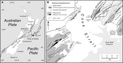
The Cook Strait region encompasses the transition from oblique westwards c. 42 mm a−1 subduction of the Pacific Plate along the Hikurangi Trough margin of the North Island to continental transform tectonics in the South Island of New Zealand (). Seismic reflection and bathymetric data imply that major transcurrent faults in the North and South islands terminate offshore in Cook Strait and are characterised by discontinuities, lateral sidesteps and a change in regional strike (Carter et al. Citation1988; Pondard & Barnes Citation2010). This has led to the assumption that through-going fault rupturing (in particular, strike-slip displacement) across Cook Strait is improbable. Nevertheless, mainshock triggering of additional rupturing on nearby discontinuous fault segments across Cook Strait is a possibility, at least during large earthquakes where loading on these faults may have accumulated a significant amount of elastic strain (e.g. Robinson et al. Citation2011). Historical evidence that this may have occurred is provided by the October 1848 (Marlborough) and January 1855 (Wairarapa) earthquakes, related respectively to mainshock displacement on the Awatere Fault in the South Island (Grapes et al. Citation1998; Mason & Little Citation2006) and the Wairarapa Fault in the southern North Island (Grapes & Downes Citation1997; Rogers & Little Citation2006). This evidence is discussed and assessed with respect to possible across-Cook-Strait fault movement and ground deformation, namely: during the 1848 earthquakes on the Ohariu and Wellington faults, with shallowing affecting Lambton Harbour at Wellington, southern North Island; and during the 1855 earthquakes, activation of the Awatere, Vernon and possibly the Needles and other faults, northeast Marlborough, South Island.
The historical evidence that forms the basis of this paper is sourced from private journals, diaries, family papers and letters, reminiscences, sourced and unsourced newspaper articles, published books, Government reports and hydrographic charts, much of which is transcribed in Grapes & Downes (Citation1997), Downes & Grapes (Citation1999) and Grapes et al. (Citation2003) together with newly located published and unpublished material. Where possible, the information is compared with more recent data to help determine reliability. Due to the difficulty in accessing most of the source material used in this paper, the relevant historical data (unpublished and published) are presented in full rather than summarised in tables in order to allow other interpretations to be made.
Fault connections across Cook Strait
Prior to seismic mapping of faults in Cook Strait (described below) there were numerous proposals to link the major faults of the Marlborough Fault System (Wairau, Awatere, Clarence, Kekerengu and Hope faults in northeast South Island) and North Island Dextral Fault Belt (Ohariu, Wellington and Wairarapa faults in southern North Island) () across Cook Strait based on simple extensions along the line of fault strike, geomorphology, geology, horizontal slip rate and earthquake magnitude. The earliest fault connection was proposed by Lyell (Citation1856c, Citation1868) who considered that the ‘rent [Awatere Fault] traversing the chain [of mountains along the northwestern side of the Awatere Valley] in a longitudinal direction is in the same line as the great Rimutaka fault [Wairarapa Fault along the eastern side of the Rimutaka Range; ] of 1855 but on the opposite side of Cooks Straits'. A map of New Zealand showing the ‘Principle Faults and Earthquake Rents’ dated 1890 was the first to show inferred straight line projections of four South Island faults – the Kekerengu (No.1), Clarence (No. 2), Awatere (No. 3) and Wairau (No. 4) faults across Cook Strait (McKay Citation1892) – but there is confusion between the map () and some of the fault descriptions in the accompanying text. The unnamed Kekerengu Fault is ‘coincident with the line of fracture and earthquake-rents running along the western side of the lower Wairarapa Plain’ (Wairarapa Fault) (). The Clarence Fault (termed the Great Clarence Fault) ‘makes itself evident on the northern shore in the vicinity of the City of Wellington’ (Wellington Fault) (also McKay Citation1902). Hector (Citation1890) was more specific in stating that the Clarence Fault ‘projected across Cook Strait, passes through the City of Wellington and along the north-west shore of the harbour, and follows the Hutt Valley…’ (). The Awatere Fault extends into the ‘southern district of Wellington… and it is this line that forms the abrupt western shore of Wellington Harbour’, although this description clearly refers to the Wellington Fault; on the map the fault connects with what appears to be the southern termination of the Shepherds Gully Fault west of the Wellington Fault (). The Wairau Fault (termed the Wairau Valley Fault) is described as passing ‘through the city of Wellington’ although it is shown as intersecting the North Island coast at Oteranga Bay, Terawhiti Peninsula (), where McKay described a wide crush zone, and is projected across the northwest corner of Wellington Harbour ().
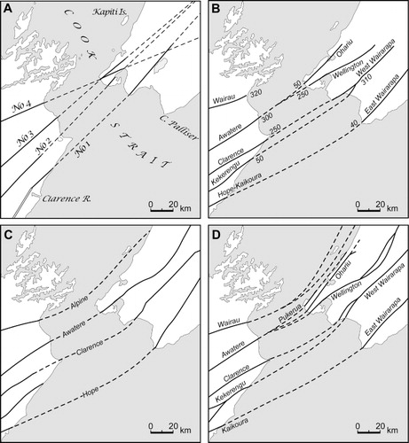
Wellman (Citation1955, Citation1956) linked the Kekerengu and Clarence faults with the Wairarapa Fault. Lensen (Citation1958; ) correlated the main South Island faults, except the Wairau Fault, across Cook Strait on the basis of earthquake magnitude and average maximum strike-slip displacement, that is, Awatere with Ohariu and Wellington faults, Clarence and Kekerengu faults with Wairarapa Fault and Hope–Kaikoura Fault with East Wairarapa Fault (). Connection of the Hope–Kaikoura Fault with the East Wairarapa Fault was also accepted by Suggate (Citation1963; ) and Stevens (Citation1974; ). Fleming & Hutton (Citation1949), followed by Kingma (Citation1957, Citation1959, Citation1974), Suggate (Citation1963) and Stevens (Citation1974), suggested the submarine continuation of the Wairau (Alpine) Fault parallel to the west coast of the North Island and east (and west; Stevens Citation1974) side of Kapiti Island (). On the basis of Neogene plate motion, Walcott (Citation1978) proposed that the Wairau Fault (or its ancestor) curved eastwards offshore towards the Cook Strait canyons (). This configuration was adopted by Harris (Citation1993), Mazengarb et al. (Citation1993), Begg & Mazengarb (Citation1996) and Begg & Johnston (Citation2000) to explain c. 130–140 km dextral offset of the Rakaia–Wellington, Esk-Head–Rimutaka and Pahau–Wairarapa Subterrane/Belt boundaries of the Torlesse terrane () in the South and North islands, respectively.
The first use of seismic profiles to trace faults across Cook Strait was by Ghani (Citation1974) who postulated major dextral jogs in Cook Strait for the Wairau Fault to connect it with the Ohariu Fault and for the Awatere Fault to connect it with the Wellington Fault (; see also Grapes & Wellman Citation1986). Katz & Wood (Citation1980) show only discontinuous traces across Cook Strait and no offsets of the major faults (). In both cases accuracy of fault plots relied on accurate positioning data; this was not always present at the time of the surveys, many of which were simply trials of the seismic instrumentation on the way to other basin surveys. Multiple problems are apparent in some of the seismic data and no digital data remain; paper copies are all that remain in the Ministry of Commerce and Institute of Geological and Nuclear Sciences (GNS) records. Seismic reflection data based on the same older petroleum dataset, supplemented by the National Institute of Water and Atmospheric Research (NIWA) 3.5 kHz profiles, soundings and near-shore side-scan sonar surveys obtained by Carter et al. (Citation1988), suggest that the faults (with the exception of the Wairau Fault inferred to extend west of Kapiti Island) terminate in central Cook Strait; this suggests a WNW–ESE-trending discontinuity (). Possible extensions of the Awatere and Hog Swamp faults in northeast Marlborough are shown to curve towards the east, possibly merging with or forming part of this discontinuity (). Later, Lewis et al. (Citation1994) showed that the main branch of the Wairau Fault also projects in an arc around the north side of the Wairau Basin and into the NW-trending Cook Strait Canyon. The most recent and comprehensive seismic reflection data of Pondard & Barnes (Citation2010) also show the major faults terminating in Cook Strait and associated with 5–20 km wide step-overs, along-strike discontinuities and a change in regional fault strike of the South Island faults from the predominantly NE–SW trend of the on-land fault traces to a more east–west trend across the Wairau Basin in Cook Strait (). The North and South island faults can be traced into Cook Strait for distances of 1–40 km (Pondard & Barnes Citation2010) ().
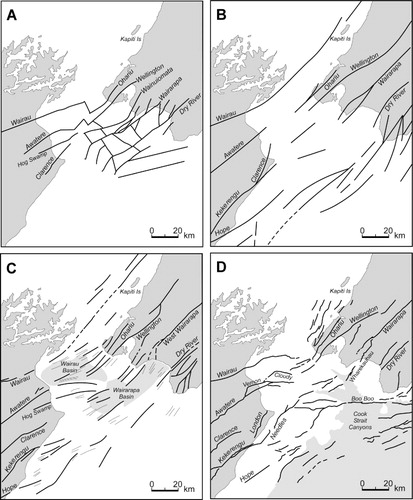
Movement on the major Cook Strait faults is documented by the onlapping latest Miocene–Holocene sequence. Faults break the seabed and a widespread unconformity that is possibly mid-Castlecliffian or younger. The opening of Cook Strait appears to be intimately linked with possible rotation and dextral slip in Marlborough and southern North Island (Lamb Citation1988; Lamb & Bibby Citation1989; Roberts Citation1995). Pliocene palaeomagnetic data suggest that the northeast Marlborough coast has rotated clockwise 20–40° about a northwest-striking kink plane since c. 5 Ma (Roberts Citation1995; Little & Roberts Citation1997; Hall et al. Citation2004), resulting in the general discontinuity between the overall ENE–WSW-striking faults in northeast South Island (Marlborough Fault System) and the NE–SW-trending faults of the North Island (North Island Dextral Fault Belt) ().
Historical evidence and deductions for surface rupturing and ground deformation
1848 earthquakes
The main shock of the 1848 earthquake sequence beginning at 01:40 on 16 October 1848 is inferred to have been caused by rupturing of the Awatere Fault over an on-land distance of 100–110 km (Lyell Citation1856b, Citationc, Citation1868; Grapes et al. Citation1998; Mason & Little Citation2006), to produce an earthquake of magnitude MW7.4–7.7 (Grapes et al. Citation1998; Mason & Little Citation2006). The main shock was followed by three very large shocks on 17, 19 and 24 October with probable magnitudes of between MW 6 and 7.5 (Eiby Citation1973, Citation1980; Grapes et al. Citation2003). The sequence of earthquakes between 16 October 1848 and 16 December 1849 is given in table 1 of Grapes et al. (Citation2003).
Ohariu Fault
In late November 1848, Reverend Taylor who was travelling from Wanganui to Wellington stopped at Waikanae and ‘lunched with Major Durie, who walked with us to see some cracks formed by the earthquakes, they run N. and S. and are about six inches wide; there are also circular holes in this place from which large quantities of gas escaped. About 2 miles [3.2 km] from Waikanae a large fissure of near 8 inches [20 cm] width opened on the side of a hill’ (Taylor Citation1848). It is not certain whether Taylor was able to examine this ‘large fissure’ or was told about it by Major Durie, but the width of the hill-slope fissure was obviously measured or estimated by close observation.
Two miles from Waikanae (the site of Major Durie's house and police barracks situated three-quarters of a mile [1.2 km] from the beach on the south side of the Waikanae River) is a hill across the west-facing front of which runs the active trace of the Ohariu Fault and along which the fissure (earthquake rupture) is inferred to have to have formed (). There is additional evidence for a very young earthquake rupture on the Ohariu Fault in the Ohariu Valley c. 18 km south of Waikanae, 14C dated at post-310–150 cal yr BP (Litchfield et al. Citation2010). These authors suggest the possibility that the few centimetres–decimetres vertical displacement observed (no horizontal displacement could be determined) represents an event triggered by the 1848 or 1855 earthquakes. The Ohariu Fault continues north from the youngest event sites in the Ohariu Valley for at least another 50 km to just north of Waikanae, and possibly for a further c. 60 km as the North Ohariu Fault (Palmer & Van Dissen Citation2002). The evidence from Taylor (Citation1848) at Waikanae thus implies rupturing on the Ohariu Fault in 1848 over a minimum distance of at least 47 km ().
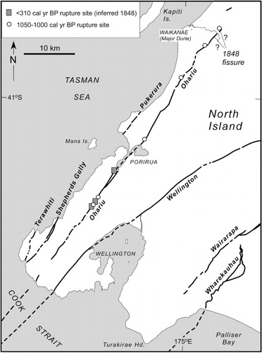
There is also 14C dating evidence for earlier co-seismicity on the Awatere and Ohariu faults during the penultimate earthquake. On the Ohariu Fault this is closely constrained from several sites between c. 19 and 47 km northeast from the Cook Strait coast () to 1050–1000 cal yr BP (Heron et al. Citation1998; Litchfield et al. Citation2004, Citation2006; Cochran et al. Citation2007). On the Awatere Fault, the penultimate earthquake has been dated at 980–1080 cal yr BP at two localities: 18 km (Lake Jasper) and 69 km (Upcot trenches) southwest from the Cook Strait coast (Mason & Little Citation2006).
Wellington Fault
James McDowell wrote a letter entitled ‘Wellington Earthquakes’, published in the 11 August 1909 Evening Post, in response to a lecture on Wellington Harbour and earthquake risks to Wellington's brick buildings by James McIntosh Bell, the then Director of the Geological Survey. McDowell refers to information he obtained from John Valentime, who experienced the 1848 earthquakes in Wellington, regarding a fissure in the Thorndon area that ‘was beyond Pipitea Point, and went up Tinakori Road and into the harbour’ indicating that it had a NW–SE trend (). Another account evidently describing the same fissure originated from Edward Withers (Citation1901), Quartermaster of the 65th Regiment stationed in Wellington at the time of the 1848 and 1855 earthquakes. In combining (and confusing) a description of both events, Withers mentions somewhat exaggeratedly, ‘Immense chasms opening up, some partially closing afterwards, one remains in a gully crossed by a suspension bridge now with a stream at the bottom and sides covered with ferns, etc.’ The so-called ‘earthquake fissure’ was a well-known feature following the 1848 earthquakes and was also referred to in the editorial of the Wanganui Chronicle and Rangitikei Observer (23 November 1901) on the 1901 Cheviot earthquake, Canterbury as ‘… it was this earthquake [1848] we believe, which caused the great crack which appears in Thorndon, Wellington, and which is believed to pass under Cook's Straits re-appearing again in that familiar feature known as ‘The Earthquake track’ running up the Awatere valley. Seen from a distance lying on the ranges at the back of Blairich Station, it appears like a road cutting on the side of the mountain, and may be traced for over 60 miles.’
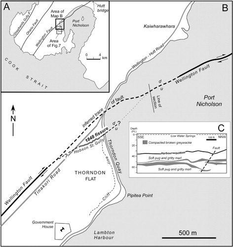
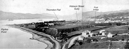
The position of the fissure (or fissures) at Thorndon described by these sources indicates that it was located along Hobson Street Gully, which was a precipitous, V-shaped stream gully (Wakahikuai Stream) c. 35 m wide at the top and 330 m in length extending across Thorndon Flat and appearing as a deep cleft in the sea cliff at Thorndon Quay (Adkin Citation1923; Hydrographic map ‘Lambton Harbour’ 1849; ), now covered by the Wellington Motorway. The gully was therefore not a fissure per se but a narrow stream-carved valley as shown in a 1860s photograph (), along which fissuring is assumed to have occurred and would suggest that the valley was (is) probably a fault-controlled feature. Whether there was any surface displacement across the supposed 1848 fissure at Thorndon, or that it formed only as a result of earthquake shaking as other fissures reported elsewhere in Wellington (Fitzherbert Citation1848; Ironside Citation1891), is unknown. The official report on damage caused by the 1848 earthquakes (Collinson et al. Citation1848) mentions that fissures formed ‘in the ground at Wellington’ were ‘long narrow cracks, not larger than those caused by a long drought’. Ironside (Citation1891) states ‘that several extensive cracks and fissures were found in the land when the [earthquake] storm subsided’, but no specific localities are mentioned in either report.
Borehole data from the Wellington Harbour Board along the site of the Thorndon (Aotea Quay) breastwork (Adkin Citation1950; ) indicates that the trend of Hobson Street Gully lies on the projected line of a fault which Adkin (Citation1950) considered to be a subsidiary fault lying c. 660 ft (200 m) east of what he assumed to be the main trace of the Wellington Fault. According to a section constructed from c. 30 ft deep borehole data (Adkin Citation1950), the fault is inferred to dip east and disrupts harbour floor layers of broken greywacke sediment (interpreted as stream wash) () which Adkin states ‘… reveals, as the Resident Engineer pointed out, a break in the sub-harbour stratification, which may be ascribed to a rather recent movement on the Wellington Fault’. The disrupted layers of ‘Pre-European’ greywacke stream wash and the harbour bottom floored by ‘Post-European … mucky pug and slimy silts’ that overlie the greywacke stream wash layers appear to be upthrown on the SE side of the fault (). Adkin conjectured that if this fault was the seaward continuation of the Wellington Fault it would imply a ‘sharp bend or offset’ in the on-land trace of the fault, which has been shown by Perrin & Wood (Citation2003) to be probable (). Whether or not there is a splay of the Wellington Fault that extends along Hobson Street Gully from this right-lateral bend or offset of the fault is unknown, but it is a tectonically feasible geometry. A distinct change in the level of the Last Glacial terrace that forms Thorndon Flat across Hobson Street Gully, shown in , suggests long-term uplift on the SE side of the proposed fault. This is consistent with the most recent displacement upthrown on the SE (harbour) side of the submarine trace of Wellington Fault (Lewis Citation1989).
There is one further unsubstantiated reference to a fissure purportedly formed during the 1848 earthquakes that may have been close, and possibly parallel, to the line of the Wellington Fault: ‘to this day a fissure several feet in width and of unknown depth near the Hutt Road, a mile or two out of Wellington, is pointed out as one of the effects of the earthquake of 1848’ (article entitled ‘The Great Wellington Earthquake [of 1848]’ published in Auckland Star on 12 June 1897). The distance of 1–2 miles (1.6–3.2 km) along the Wellington–Hutt-Valley road, from Thorndon for example, would place the fissure near Kaiwharawara and several hundred metres west of the submarine trace of the Wellington Fault (Lewis Citation1989; ). The fissure width of several feet suggests that it may have formed as a result of slumping of unconsolidated deltaic sediments that form the Kaiwharawara Stream salient into Wellington Harbour (), possibly due to movement on the Wellington Fault, that is, upthrown on its SE side (Lewis Citation1989).
The effects of the early morning aftershock on 19 October 1848, considered to be the most violent of all the large earthquakes in the 1848 sequence including the mainshock (e.g. New Zealand Spectator and Cook's Strait Guardian 25 October 1848; Eyre 1848 in British Parliamentary Papers Citation1849; Chapman Citation1849), and its northward propagation were experienced in the lower Hutt valley from the bridge over the Hutt River (location shown in ). According to Hansard (Citation1848), ‘The policeman standing on the Hutt bridge before sunrise of the 19th, saw the river greatly agitated, and two or three seconds afterwards, the ground shook beneath his feet. Just then, the bridge received the injury it is now seen to have sustained – the road for a considerable distance rose and subsided like the waves of the sea; the motion gradually approached, and the policeman and his companion plainly felt it pass in an opposite direction towards the North’. The ‘injury’ done to the bridge, constructed in 1847, was damage to one of the abutments and straining of the superstructure.
The formation of a fissure at Thorndon along Hobson Street Gully extending across the beach, into the harbour and up Tinakori Road, the fissure inferred to have formed at Kaiwharawhara, the Policeman's account from the Hutt valley bridge and the severity of the 19 October earthquake in Wellington (felt intensity of MMVII–MMVIII; Grapes et al. Citation2003) all suggest the possibility of northwards propagation of rupturing along a segment of the Wellington Fault at this time.
Lambton Harbour
A draft (Lyell Citation1856a) of Sir Charles Lyell's well-known articles reporting the details of the 1855 earthquake (Lyell Citation1856b, Citationc, Citation1868) mentions that ‘During a former earthquake in Oct. 1848 the land at Wellington was much fissured and raised and the soundings in the harbour of Port Nicholson altered so that vessels were not able to anchor so near to the shore as previously’, implying some uplift. A remark by the Wellington Harbour Master Charles Sharp, that ‘between Oct 1848 & 1855 the whole [uplift] movement of 5 ft’ at Wellington recorded in Lyell's notes of an interview with Edward Roberts, Clerk of Works for the Wellington Provincial Government and a Royal Engineer, would seem to offer indirect evidence for this uplift (Lyell Citation1856a). Additional information is provided by Reverend Richard Taylor: ‘several fissures were formed, and the land was raised so much that the small craft which were accustomed to anchor close in shore, were obliged to change their ground’ (Taylor Citation1855). While Taylor's extract could be, and has been, dismissed as confusion with the well-known uplift that occurred in Wellington during the 1855 earthquake (Grapes & Downes Citation1997), it needs to be considered in its respective context. Taylor was in Wanganui in 1848 and recorded the effects of the earthquakes there. Following the extract quoted, he describes the effects of the 1855 earthquake in Wellington by writing ‘At Wellington, the harbour is stated to have been raised full four feet and a half, and similar changes have taken place in every part of the district’, so there is no confusion with his statement that some uplift also occurred in 1848. Taylor was a careful observer and recorder of natural history, as seen from his book Te Ika a Maui published in London in November 1855, but in this case he does not name his source. Lyell was aware of Taylor's book and it is possible that his quote was taken from it or related to him by one of the eyewitnesses of the 1855 earthquake that he interviewed in 1856. The identification of Taylor's as-yet unknown source would provide critical evidence for uplift in Lambton Harbour in 1848. This may have been Edward Roberts, who was in Wellington in 1848; he was engaged in several harbour reclamation projects (in 1852, 1853, 1854) and provided Taylor with a ‘Memorandum on the earthquake in the islands of New Zealand, January 23, 1855’ that was published as an appendix in his book (Taylor Citation1855). Roberts also supplied Lyell with information about the effects of the 1855 earthquake (Lyell Citation1856a).
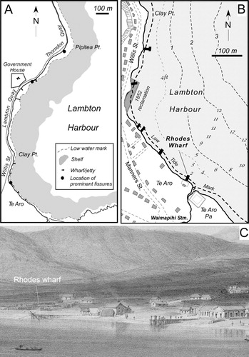
Although shallowing of Lambton Harbour or parts of it in 1848 would be consistent with uplift on the SE side of the Wellington Fault (Adkin Citation1950; Lewis Citation1989), a decrease in near-shore water depth as a result of liquefaction and lateral spreading of bottom sediments during the earthquakes is also a possibility considering the shallow bathymetry, nature of the bottom sediment and substrate. According to various sources, there is a ‘flat extending around Lambton Harbour for a considerable distance beyond low tide mark, and from which it suddenly shelves into deep water’ (report by Byron Drury in the New Zealand Spectator and Cook's Strait Guardian, 24 February 1855; ); ‘the shore shelves off gradually from low water mark … with a soft muddy bottom' (Carkeek & Sharp Citation1852); and, concerning the feasibility of constructing a wharf near Clay Point in Lambton Harbour, Edward Roberts (Citation1853) pointed out that the ‘obstacle to a piled jetty is the impossibility of driving piles farther than about three feet into the ground, in consequence of the rocky nature of the bottom immediately under the superstratum of mud.’ During and after the earthquakes, prominent fissures were described by many sources on the beach fronting Lambton Harbour (). For example, ‘a crack was discovered on the beach [after the shock of Tuesday 17th] from the west of Colonel Gold's house [Te Aro flat] to McBeths [Willis Street] store nearby’ (Oliver Citation1848). Samuel Chapman, a conscientious recorder of the 1848 earthquakes, mentions ‘… a slight change of surface on the beach at Wellington – where one side of a slight fissure was left a few inches below the other, some pi-pi (cockle) shells having been pushed to the surface’ (Chapman Citation1849). According to reports in New Zealand Spectator and Cook's Strait Guardian on 25 October 1848, ‘several cracks or fissures were observed in the earth [after the shock of Thursday 19th], the most remarkable being on the beach on Thorndon Quay a short distance beyond the Cottage of Content’ [hotel on Thorndon Quay near Pipitea Point]. Ironside (Citation1891) wrote: ‘I remember putting my walking stick, a big stout one, into a fissure a little west of Barrett's Hotel [Lambton Quay]. I held the stick by its knob, and let it fall to its entire length, but could feel no bottom; I moved it to and fro, but it was empty space, so far as my limited means of examination could determine’. It seems possible that these beach fissures may have been manifestations of seaward movement of shallow bottom sediments and their re-deposition across the shelf area surrounding Lambton Harbour (), causing the shallowing described.
A search for corroborative evidence of any uplift or change in water depth in Lambton Harbour during the 1848 earthquakes (e.g. in newspapers, Wellington Harbour Master's reports for 1848 and 1849 and inwards correspondence to the Colonial Secretary) failed to find anything. There are however reports to the contrary by Commander Byron Drury of HMS Pandora who was in Wellington during the 1855 earthquake and who resounded the harbour after the earthquake uplift that occurred at that time, and from Charles Mills and Charles Carter who were commissioned to produce a report on the same earthquake by the Wellington Provincial Government. Drury wrote ‘I am inclined to believe that the upheaving which certainly did take place on the 23rd ult. [1855] was the work of an instant, and within the following 12 hours, when the sea was seen approaching and receding in such an extraordinary manner. This was not observed in 1848, because there was no change in the level.’ (New Zealand Spectator and Cook's Strait Guardian, 24 February 1855). Mills & Carter (Citation1855) stated that on ‘the recent [1855] sudden upheaval of part of the Province of Wellington, there is good reason to believe is a rare occurrence. No white man that we can learn of has ever witnessed it before. One of the oldest inhabitants of Cook's straits, Mr. John Guard [a whaler based in Tory Channel, Marlborough Sounds], says “the last earthquake was the most violent one he ever knew in this country”, and he has lived in it for a period of twenty-two years, and he never before witnessed a perceptible rise of the land after the shock of an earthquake.’ Drury's information came from an unknown informant or informants, almost certainly in Wellington, and probably government officials who were either unaware of or dismissive that any obvious uplift (permanent or temporary) of the harbour had occurred during the 1848 earthquakes. John Guard was not in Wellington at the time of the 1848 earthquakes.
Nevertheless, evidence for a change in water depth in Lambton Harbour between 1841 and 1849 (when the HMS Acheron completed a detailed survey of Lambton Harbour) can be demonstrated at Rhodes Wharf at Te Aro (), c. 2 km south of the Wellington Fault at Thorndon. Rhodes Wharf was the first wharf to be built in Lambton Harbour (by W.B. Rhodes and Co. in 1841) and was described as ‘substantial’ with ‘four feet at low tide and nine feet at high water’, that is, the maximum tidal range of 5 ft (1.52 m) in Port Nicholson (The New Zealand Gazette and Wellington Spectator, 20 March 1841). The water depths quoted presumably refer to the harbour end of the wharf which had a length of c. 60 ft (18.3 m). On the Acheron map of 1849 (Hydrographic Department of the British Admiralty Citation1849) two sounding tracks converge at Rhodes wharf and indicate a low water springs depth of 2 ft (0.6 m) (), implying a shallowing of about this amount between 1841 and 1849; some of this may have been due to tectonic uplift or possibly lateral spreading related to the fissure on Te Aro beach recorded by Oliver (Citation1848) during the 1848 earthquakes. Construction of a 300 ft shore-shallow water profile from the Acheron survey and the steep beach profile evident in the 1842 lithograph by William Mein Smith () indicates that tectonic uplift of 2 ft (0.6 m) would result in a seaward shift of the low water springs mark by c. 4–5 ft (1.2–1.5 m). Another possible cause of shallowing is accelerated deposition of sediment into the harbour following the 1848 earthquakes, particularly as Rhodes Wharf is situated near where Waimapihi Stream debouches into Lambton Harbour (). In the 1850s, deforestation in the area of the headwaters of this stream (Poolhill Gully) caused extensive deposition of sediment that built a prominent, tongue-like extension of the shoreline immediately east of the wharf as shown in a photograph of Te Aro in c. 1857 (F.J. Denton; reproduced as fig. 18 in Grapes & Downes Citation1997) and documented in legal proceedings relating to claims of this part of the Te Aro foreshore reported in the Evening Post (6 September 1907). Such an extension of the foreshore at low tide is not shown on the 1849 Acheron Lambton Harbour map, indicating that there was no obvious accelerated deposition by the stream following the earthquakes in 1848 or when bush clearing of the hills surrounding Wellington had not been carried out to any great extent. Nevertheless, over the 7 year period between the construction of the wharf and the earthquakes in 1848, some deposition of sediment from this stream into the shallow part of the harbour at Te Aro must have taken place and the 2 ft difference in water depth can only provide a maximum possible tectonic uplift and/or shallowing by lateral spreading in 1848 at this locality. Unfortunately, no reports have been found mentioning that Rhodes Wharf was extended following the earthquakes in order to maintain the pre-earthquake water depth of 4 ft (1.2 m) at low tide.
Although this example provides support for the statements of Lyell, Taylor and possibly the Harbour Master Charles Sharp that there was uplift or shallowing of Lambton Harbour during the 1848 earthquakes, the cause is problematical; the fact that nothing was reported during or after the earthquakes, especially in the Wellington newspapers, is discouraging. A possible explanation could be the occurrence of unusually high tides during the earthquakes variously documented: (1) as the result of prolonged SE gales which blow directly into the harbour and heavy rain rising 1 ft above high water springs eight hours after the first shock on October 16 (Chapman Citation1849); (2) on the morning of 18 October (about 11 hours after the 15:40 shock on the 17th) when the tide, although at neap, rose 18 inches above high water springs level and flooded the beach road around Lambton Harbour and the lower parts of houses (New Zealand Spectator and Cook's Straits Guardian, 18 October 1848; Fitzherbert Citation1848; Thomas Citation1848; Chapman Citation1849); and (3) an ‘unusually high tide’ on 19 October, about six and a half hours after the shock at 05:03 (Thomas Citation1848). It was concluded at the time that these abnormally high tides attracted more attention than usual because they occurred during the earthquakes, but they were not associated with the times of the main shocks (Fitzherbert Citation1848; Chapman Citation1849). Ironside (Citation1891) also remarks that the ‘vagaries of the inflow and receding of the waters caused no doubt by submarine action, were remarkable’. While there are reports of unusually high tides flooding and damaging the beach road and parts of its retaining wall fronting Lambton Harbour prior to the 1848 earthquakes (e.g. New Zealand Spectator and Cook's Strait Guardian, 10 May 1848), no reports of tidal flooding have been found between October 1848 and the 23 January 1855 earthquake when prolonged seiching occurred in Port Nicholson (Grapes & Downes Citation1997). This suggests that, if there was tectonic shallowing of the harbour in 1848, it was sufficient to prevent the low land fronting Lambton Harbour (Te Aro and Lambton Quay in particular) from being inundated during storm-induced higher-than-normal high tide levels.
1855 earthquakes
The 23 January 1855 MS ≅ 8.2 earthquake was caused by rupturing of the Wairarapa Fault over an on-land distance of c. 120 km and possibly for a further c. 40 km into Cook Strait on the offshore extension of the Wharekauhau Fault. It involved vertical and horizontal fault displacement and northwest tilting affecting the southwest North Island and northeast South Island (Lyell Citation1856b, Citationc, Citation1868; Grapes & Wellman Citation1988; Grapes & Downes Citation1997; Grapes Citation1999; Schermer et al. Citation2004; Barnes Citation2005; Rogers & Little Citation2006; Grapes & Downes Citation2010). The sequence of aftershocks from 23 January to 2 May 1855 is listed in Grapes & Downes (Citation1997). The mainshock at 21:11 on 23 January was followed by a tsunami and large aftershocks within a few hours and over the next few days; these were strongly felt along the northeast Marlborough coast with at least one aftershock generating a tsunami on 3 February (Grapes & Downes Citation1997). A comprehensive record of earthquakes from the main shock on 23 January until 11 February, kept by Alexander Mowat (Citation1855) of Altimarlock Station, Awatere Valley c. 30 km from the coast, suggests intensities of MMVIII and possibly MMIX. Frederick Trolove (Citation1855) on the Marlborough coast suggested intensities of MMVII to possibly MMIX (both accounts transcribed in Downes & Grapes Citation1999).
Awatere Fault
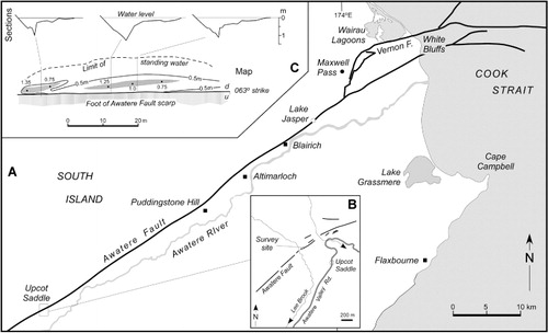
According to the Nelson Examiner (21 February 1855) in the Awatere Valley, ‘nearly all the cob buildings, within twenty miles [32 km, to Altimarlock] of the sea, were more or less damaged, but beyond this the force of the shocks sensibly diminished’. There are several reports of fissures being formed or being re-opened along the Awatere Fault during the 1855 earthquakes. Although these were written or communicated many years after the earthquake, it is clear that all the sources were aware of the formation of a fissure along the Awatere Valley prior to the 1855 earthquake and that it was a prominent feature or ‘a great rent’ that formed in 1848, as documented by Lyell (Citation1856c, Citation1868) and Hochstetter (Citation1863, Citation1864). From information on the effects of the 1855 earthquake supplied by Julius von Haast who visited the lower Awatere and Wairau valleys during 12–24 September 1859, Hochstetter (Citation1863) records, ‘In the Awatere Valley the surface split and fissures and scarplets formed. One of these fissures could be continuously followed for 40 English miles, of which traces could still be observed by my friend Haast in 1859, some of them 3 feet wide and several feet deep.’ As Haast only travelled c. 20 km up the valley (from Maxwell Pass to Puddingstone Hill via Blairich and Altimarlock stations; Hochstetter Citation1859; ), he must have obtained the information about one particular fissure (or fissures) extending for 40 miles from locals, presumably the Mowats of Altimarlock Station and the McRaes of Blairich Station. In his Geology of New Zealand, Hochstetter (Citation1864, p. 38) confirmed the information that, in 1855, in ‘the Awatere Valley (Marlborough) the ground suffered powerful rents and fissures which could be followed for a distance of 40 miles and still gaped locally several feet wide in the year 1859’. He was well aware of a fissure which had formed along the Awatere Valley in 1848, and refers to this as ‘a great rent’ and a ‘remarkable phenomenon. It is visible on the north side of the river [Awatere River] from White Bluff, over hill and vale for a distance of many miles, right to Berfeld's [Barefell] Pass (). In many places, the fissure is said to be 5 to 6 ft. deep and 30 ft. broad and it resembles a canal without water for miles on end’ (Hochstetter Citation1864, p. 231). Twenty years later, when commenting on Alexander McKay's observations of the Awatere Fault, Sir James Hector (Citation1890) wrote, ‘It has till now been considered that this Awatere earthquake-rent had its origin in and was caused by the earthquakes of 1855. Mrs Mouat [Mowat] of Altimarlock informed Mr. McKay that the open rents and fissures yet to be seen on the surface along the line of fracture were not produced by the disturbances of 1855 but were caused by the earthquakes of 1848. It may have been as stated, but it is equally probable that fresh fractures may have taken place on both dates. Mr. McKay came to the conclusion, and both here [Altimarloch Station] and further up the valley obtained distinct proof, that the earthquakes of 1848 and 1855 did but open afresh an old line of dislocation, and produced meagre results compared with the total movement which has taken place along this line.’ How McKay was able to obtain this ‘distinct proof’ and the evidence he used is not stated, but during 1888–1889 he examined the geology of the Awatere Valley as far as Middlehurst (92 km from the Cook Strait coast; Grapes Citation2009) and may have obtained eye-witness information of the 1855 fissuring from the upper Awatere Valley stations (Glenlee, Camden, Mt Gladstone, Upcot, Middlehurst, Langridge and Muller; Kennington Citation1978) that had been settled since the early 1850s.
Other reports describing rupturing along the fault during the 1855 earthquake state that ‘On Fairfield Downs [upper Awatere Valley], a fissure was opened as far as the eye could see, and perfectly straight’ (letter in Hawkes Bay Herald, 20 January 1894, from ‘a pioneer of the early fifties’ who was living in Wellington in 1855, but went to Marlborough soon after the earthquake to investigate an erroneous report of an erupting volcano); according to James McKay, who was near Cape Farwell during the 1855 earthquake and experienced the effect of tsunami waves on the spit, in the Awatere Valley ‘an enormous rift was made, which was of considerable depth and width, and extended for several miles in a straight line, and I believe it can still be traced. I have not seen it for thirty-two years [since 1862], but it was very plainly visible then’ (article entitled ‘Quaky Wellington, some historical earthquakes’ in the Auckland Star, 25 May 1894); and ‘the earthquake crack in Marlborough was much enlarged…’ (article by H.C. Field, an engineer based at Wanganui who arrived in New Zealand in 1851 and wrote a number of articles on the earthquakes he experienced in 1855, 1891 and 1897, including ‘Wanganui earthquakes’ in the Wanganui Herald, 19 June 1902). In an article entitled ‘Nature Notes’ in the New Zealand Herald, 1 April 1922, James Drummond (a well-known science writer/journalist) records that ‘Marlborough residents date the fracture [Awatere Fault] from two historical earthquake years, 1848 and 1855. Although deep rents were made in the fracture in those years, it was a line of weakness long before the Europeans came to New Zealand’.
The amount of displacement, if any, on the Awatere Fault during the 1855 earthquake cannot be determined. It would be virtually impossible to see any definitive geomorphic evidence of vertical or horizontal movement on the fault at this time given the 7 year interval between the two earthquakes, but the smallest mean horizontal displacement assumed to represent the latest movement (or possibly the sum of two co-seismic movements) on the fault is 5.3 ± 1.6 m over an on-land distance of c. 110 km (Grapes et al. Citation1998; Little et al. Citation1998; Mason & Little Citation2006). Fissuring along the line of the Awatere Fault is preserved at Upcot Saddle in the upper Awatere Valley and was revealed by augering across a shallow marshy area ponded against the fault scarp (). Profiles indicate two distinct en echelon fissures up to 1.35 m deep and 3 m wide at the surface and a suggestion of uplift on the northwest side, but the earthquake which caused the fissuring (although obviously ‘recent’) could have been 1848, 1855 or both.
Vernon Fault and lower Wairau Valley
Observations of fissuring along what could be the Vernon Fault () were made in 1856 by W.H.S. Roberts in a series of articles entitled ‘Overland from Nelson to Southland in 1856’ (North Otago Times, 22 June 1894). Roberts refers to the track generally used between the Wairau and the Awatere valleys via Maxwell Pass, and recollected ‘… a crack or chasm across the hills at this pass, in places more than a foot wide, which had been made by the earthquake in 1854 (sic). It was very dangerous. I dropped stones into it to try and ascertain the depth, but could only hear them tumbling from side to side, until the sound was lost in the unknown abyss. The track on reaching the Awatere plain turned westward’. The section of the Vernon Fault that crosses the Maxwell Pass track consists of two NNE-striking strands c. 300 m apart and 2.1–2.3 km southeast of Maxwell Pass ().
Historical evidence also indicates subsidence of the Wairau lagoons area on the northern side of the Vernon Fault in 1855 () of 0.5–0.6 m to as much as 1.5 m (Mason Citation1855; Roberts Citation1855; unknown source quoted in Buick Citation1900; Budge, 1855, letter to Superintendent of Nelson, quoted in McIntosh Citation1940; see also Grapes & Downes Citation1997, Citation2010 for discussion). Displacement on the Vernon Fault is dominantly strike-slip (vertical component of long-term movement up to 0.14 ± 0.05 mm a−1) as determined by Clark et al. (2011) who also suggest that a portion of the vertical displacement that does occur on parts of the shallow south-dipping Vernon Fault may result in absolute uplift of the Vernon Hills to the south of the fault, rather than absolute subsidence of the Wairau lagoon area to the north. Hayward et al. (2010) show from lithological and microfossil evidence that there has been 3–4 m of subsidence along the south side of the Wairau lagoons in the last 3–4 ka, and suggest either gradual subsidence or a series of small downthrows on the north side of the Vernon Fault. In another area c. 2.6 km northwest of the fault they document earthquake-induced subsidence of c. 0.5 m that is attributed to the 1855 earthquake, confirming the historical evidence quoted above. Subsidence of the lagoons area that occurred in 1855 was the result of local compaction and regional tectonic tilting caused by uplift on the Wairarapa–Wharekauhau faults in southern North Island (Grapes & Downes Citation1997, Citation2010; Hayward et al. Citation2010; Clark et al. Citation2011), with tectonic subsidence of the lower Wairau Valley terminating at the Vernon Fault. This is supported by the fact that the coastal route around White Bluffs (immediately south and on the upthrown side of the fault; ) does not appear to have been adversely affected, although ‘…the tides after Jany 1855 were irregular at the White Bluffs for weeks’ (Lyell Citation1856a).
Coastal area, northeast Marlborough
Severe aftershocks of the 23 January 1855 earthquake were reported from the northern coastal area of Marlborough and are discussed by Grapes & Downes (Citation1997, pp. 357–358). Following the main shock at 21:11, another of even greater severity occurred in ‘the middle of the night’ (Trolove Citation1855); this was probably the same shock as that described by Frederick Weld which he ‘supposed to be local’ and ‘had the same strength as the first one’ (Lyell Citation1856a). Three ‘heavier shocks than any before’ and another about an hour later were recorded by Frederick Trolove (Citation1855) during the night of 24/25 January. The damage described by Trolove suggests a local source for these strong aftershocks (probably up to MMVIII) (Grapes & Downes Citation1997). These ‘local’ shocks evidently caused widespread landsliding along the Kaikoura coast. Between Kekerengu and ‘The Flags’ (), a few days after 23 January Trolove (Citation1855) found ‘the hills very much shaken and split’ and between Kekerengu and the Clarence River ‘the overhanging hills along the beach are now bare of vegetation as can be well imagined owing the slips’. David Monro (Citation1855) noted that, opposite Lake Elterwater () on Weld's Flaxbourne station, ‘in many places the ground is very much cracked and the sides of the hills [London Hill east of Lake Elterwater] have slipped’. Lyell (Citation1856a) notes ‘Sev[e]ral landslips into the sea & into valleys took place. This was chiefly S of Cape Campbell to Waipapa Point’ (Clarence River mouth salient 57 km southwest of Cape Campbell). At Cape Campbell itself, ‘parts of the mountain fell exposing white rocks’ (Hochstetter Citation1864).
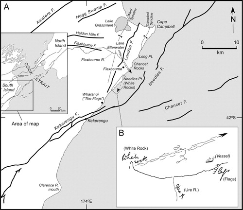
Information for uplift of the coastal area of northeast Marlborough during the 1855 earthquakes is recorded by Lyell (Citation1856a) from information supplied by Frederick Weld. This included uplift at Lake Grassmere (at that time called Kaiparatehau) and further south at Flaxbourne (): ‘A lake called Kaiparatehau wh[ich] was large & near 1 ½ miles in diameter now 4 ft. [1.2 m] higher than it was – no filling up, rocks & stones now stirred up in it. It was below the level of the sea, now it drains thru’ the shingle banks and is smaller & smaller as the land rose – chiefly perhaps in 1848 but seemingly gradual [presumably a reference to gradual shallowing of the lake as a result of sedimentation]. Wall made near the lake of sod or an embankment which is now many yards (30) [27 m] from the water in ordinary state of the water – this may be owing to about 2 ft. [0.2 m] rise of the land [in 1855]’. There are also the statements: ‘At the station lake [Lake Elterwater] at Flaxbourne there was an out-house of people living up the valley of F [Flaxbourne]. People c[ould] not see the sea but after the earthquake of 1855 they could’, and ‘Whether the upper part of the valley rose as did the W. [Wairarapa? Wairau? surface] or the lower sank unknown’ (). The mention of uplift causing the lake to become smaller in 1855 but ‘chiefly perhaps in 1848’ is curious as there is no immediate evidence of coastal uplift south of the Awatere Valley in 1848 and in 1855, according to Weld, ‘the tides were very irregular after the earthquake so that it was impossible to tell whether there had been any uplift or subsidence except at favoured spots’. As there is beach ridge evidence of Quaternary uplift in the Lake Grassmere area (Ota et al. Citation1995), perhaps some uplift (the 2 ft mentioned by Lyell Citation1856a) in 1855 is not unexpected. The other statement of Lyell about being able to see the sea after the earthquakes from the western side of Lake Elterwater in the Flaxbourne River valley provides better evidence for tectonic uplift. The site provided a clear line of sight down the Flaxbourne River by way of an opening through the coastal hills to the sea (arrowed line in ). Additional information concerning possible uplift at Flaxbourne comes from a letter written by an employee of Flaxbourne Station, Mr Edward Roberts, to the previous station manager, E. Weld (son of Frederick) about the effects of past earthquakes and asking if the river had been shallowed by the 1855 (‘big’) earthquake. The reply (dated 7 January 1949) states ‘Flaxbourne River was deep enough for small craft to come up as far as the old boiling-down plant, and that was the reason that the original homestead was established a short distance further up the river. The big earthquake of which you speak in your letter was responsible for the alteration’ (Weld Citation1949). A personal communication in Cotton (Citation1914) states that the same E. Weld informed him that the bed of the Flaxbourne River had been ‘perceptibly raised’ (cause not stated); Cotton concluded that the shallowing was due to aggradation resulting of man-made destruction of the original vegetation. When the area was first settled in 1847 by Frederick Weld it was largely grassland and certainly not forested (Weld Citation1846–51), but the possibility of aggradation in the Flaxbourne River caused by earthquake-induced landslide debris (as described above) is a more likely explanation.
The characteristics, extent and effects of tsunami generated by the main shock of the 1855 earthquakes on 23 January are documented by Grapes & Downes (Citation1997). The same authors also discuss evidence for tidal disturbances affecting the Kaikoura coast, Marlborough; these were caused by severe aftershocks that appear to have been localised to that area as they were not specifically recorded as particularly strong in the Awatere Valley or in Wellington (Grapes & Downes Citation1997). The effects of tsunami were observed by Frederick Trolove (Citation1855) on 26 January (‘The sea has been inland many feet above high watermark. Indeed in some places the sea occupies what used to be green bushes and grass’) and 30 January (‘My boat at the Flags was taken away 20 yards [18 m] inland by the roll which came in from seaward and left high and dry on the green sward’). It is unclear from the above extracts if they refer to the result of tsunami that followed the main shock on 23 January, or of one or more tsunami generated by the strong shocks that occurred during the nights of 23/24 and 24/25 January as felt on the Kaikoura coast (Grapes & Downes Citation1997). Lyell's statement (quoted above) of ‘several landslips into the sea’ between Cape Campbell to the Clarence River suggests that local tsunami may have been generated, although the timing of the landslips is not recorded. A local tsunami was produced by an aftershock on 3 February. Trolove (Citation1855) was loading wool onto a ship from the beach at ‘The Flags’ (Wharanui; ) and observed ‘a heavy shock out at sea. It made the sea appear on the horizon like a hilly and undulating country; it also caused a swell on the beach for about an hour after.’ An account of what appears to have been the same earthquake is also given by Lyell (Citation1856a) and provided by Frederick Weld: ‘Some people who were loading a vessel with wood [sic. wool?] at a place called the Flags south of Cape Campbell, saw the sea [“movements of the” crossed out] earthquake at a distance of three miles north of them at a place called the White Rocks [Needles Point]. It was made manifest by clouds of dust and by the rolling of stones from the tops of the cliffs and an undulatory motion in the sands of the beach. As it approached them it was accompanied by a wave of the sea which broke upon the coast. Mr. Weld says that there were waves in opposite directions which occasioned differences of opinion as to whether the earthquake travelled from NE to SW or in a contrary direction.’ Lyell (Citation1856a) also records that the wave was ‘outside or seaward of the vessel leaving her in smooth water between the wave & the land’, and provides a diagram () showing the course of the sea disturbance travelling in a southeast direction and that the same wave ‘broke upon the N. East coast of the Middle Island for a distance of about 50 miles’. This earthquake and the apparent narrow zone of disturbed water and ground disturbance travelling in a southeast direction suggests NW–SE fault rupturing and associated coastal rock falls and submarine slumping.
Discussion
The distribution and density of faults and their apparent terminations in Cook Strait () suggest that stress loading associated with large-magnitude earthquakes could trigger movement on nearby faults (e.g. King et al. Citation1994; Pondard & Barnes Citation2010), potentially resulting in a cascading of fault rupturing across Cook Strait. Coulomb static stress modelling of hypothetical and historical earthquake rupturing across Cook Strait by Pondard & Barnes (Citation2010) suggests lateral stress loading of c. 100 bar with an area of c. 10 km from the ends of ruptured faults, decreasing to c. 1–10 bar away from the faults. Although the stress increase is much less than that released in the initial earthquake, its effects can be significant. If the stress change is transient it could result in a burst of aftershocks in the days and weeks following the mainshock (Parsons Citation2005), some of which may be large enough to indicate additional fault displacement. This appears to have occurred during the 1848 and 1855 earthquakes.
The 1848 earthquake sequence began at 01:40 on 16 October with mainshock rupturing for c. 110 km along the Awatere Fault in northeast Marlborough and probably extending into Cook Strait for a further c. 10 km, that is, as far as the continuous trace of the fault is mapped and/or on another subparallel fault to the east (Pondard & Barnes Citation2010; ). As there is no evidence of tectonic subsidence of the Lower Wairau Valley, northeast Marlborough in 1848, although localised subsidence due to compaction and liquefaction were observed, it would appear that there was no transference of movement from the Awatere Fault to the Vernon Fault at this time.
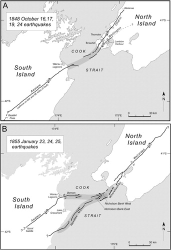
Within a period of one week following the mainshock (to the strong aftershock of 24 October), large shocks triggered by stress transfer and loading (e.g. Reasenberg & Simpson Citation1992; King et al. Citation1994; Harris & Simpson Citation1998; Stein Citation1999; Robinson Citation2004) are inferred to have been associated with movement on the Ohariu Fault and possibly the Wellington Fault which may have extended from Cook Strait, that is, on their submarine traces of c. 20 and 25 km, respectively (Pondard & Barnes Citation2010; ). Information that could support a Cook Strait extension of rupture is reported in the New Zealand Evangelist (Citation1848): ‘From the Heads [entrance to Port Nicholson] round to Cape Terawite [Terawhiti; i.e. Cook Strait coast of the Wellington Peninsula; ] large rocks were rent, and fragments rolled down and were precipitated into the sea’. There is no evidence for very recent displacement of the Vernon and Cloudy faults that intervene between the Cook Strait terminations of the Awatere and Ohariu–Wellington faults (Pondard & Barnes Citation2010; ). From the localities of probable 1848 vertical displacement on the Ohariu Fault (Litchfield et al. Citation2010; this paper), the submarine–on-land rupture length could have been c. 80 km (). Apparent shallowing in Lambton Harbour would be consistent with tectonic uplift (probably < 0.6 m) on the southeast side of the Wellington Fault, but the extent of any uplift along and east of the fault is unknown and there is no evidence indicating horizontal movement. The available data is inconclusive as to whether 1848 shallowing in Lambton Harbour was the result of uplift on the Wellington Fault or lateral spreading of shallow harbour sediment. From the evidence at hand, we conjecture that any fissuring (implying seismogenic displacement) along the Wellington Fault in 1848 probably took place during the large shock of 19 October and that it was perhaps only a few centimetres (vertical) at most, as recorded for the most recent (1848) rupture along the Ohariu Fault.
Radiocarbon dating constrains the timing of the most recent earthquake displacements on the Ohariu and Wellington faults to <310 cal yr BP (Litchfield et al. Citation2010; Langridge et al. Citation2011), and is therefore not incompatible with an inferred small amount of movement on both faults in 1848. Coincidence of the timing of the penultimate earthquake or earthquakes on the Ohariu and Awatere faults at c. 1000 cal yr BP reinforces the notion of a triggered earthquake link between these faults (Van Dissen et al. Citation2007).
The 23 January 1855 MS ≅ 8.2 earthquake was caused by rupturing of the Wairarapa Fault over an on-land distance of c. 120 km and for a further c. 35 km into Cook Strait on the offshore extension of the Wharekauhau Fault zone and possibly the Nicholson Bank East Fault (). Northwest tilting affecting the southwest North Island and northeast South Island indicates that rupturing during the mainshock also extended across Cook Strait, probably via the Nicholson Bank West Fault, to the offshore extension of the Vernon Fault, for 15 km along the on-land trace of this fault (resulting in tectonic subsidence of the lower Wairau Valley, terminating to the south along the Vernon Fault) and along the Awatere Fault for a further c. 60 km (). Linkage between the Vernon and Awatere faults is suggested by a dextral slip rate of ≤3.9 mm a−1 on the Vernon Fault, consistent with the transfer of a significant portion of the slip on the Awatere Fault to the Vernon Fault (Little et al. Citation1998; Clark et al. Citation2011; ). This may have occurred during the 1855 earthquake as the smallest dextral displacements (two sites) on the Awatere Fault northeast of where the Vernon Fault splays from the fault are c. 4 m, whereas southwest of this junction the smallest displacements (14 sites) are c. 6–7 m (Grapes et al. Citation1998; Little et al. Citation1998; Benson et al. Citation2001; ).
Faulting and deformation in Cook Strait in 1855 almost certainly caused extensive landsliding into the Cook Strait and Nicholson canyons from the Nicholson Bank area (Barnes Citation2005), resulting in a tsunami and the deaths of thousands of bottom-dwelling fish that were found floating in the middle of the strait following the earthquake (Grapes & Downes Citation1997). The historical evidence relating to the 1855 earthquake analysed by Grapes & Downes (Citation1997) indicates that the mainshock had a duration of at least 50 s and probably consisted of two events with an epicentre in Cook Strait close to Wellington at a depth of 25 km. We suggest that the two events which made up the mainshock may have been: (1) bilateral rupturing of a probable listric fault plane (Darby & Beanland Citation1992) northeast along the Wharekauhau and Wairarapa faults; and (2) a cascading progression west and southwest across Cook Strait possibly via the Nicholson Bank West Fault to the Vernon and Awatere faults in northeast Marlborough. These two events led to the formation of a c. 280 km long seismically active zone for the 23 January 1855 mainshock(s) ().
About 6 hours (03:00; 24 January) after the first shock(s), the large (‘local’) earthquake strongly felt along the northeast coastal area of Marlborough suggests triggered rupturing of the offshore Needles Fault, closely co-aligned with the Nicholson Bank East Fault (), which may have generated additional tsunami. With respect to the other large aftershocks (four in number) that were felt on the Marlborough coast during the night of 24/25 January, felt intensities documented in Grapes & Downes (Citation1997; p. 357–358) suggest that these earthquakes could also have been initiated off the coast close to Kekerengu (); this would indicate possible southwards propagation of rupturing along the Needles Fault to the Kekerengu Fault (). On the afternoon of 3 February 1855, a local earthquake that generated a southeast-moving standing wave along the northeast Marlborough coast () suggests rupturing either on the NNE–SSW-striking London Fault or a parallel, blind fault between the London Fault and Needles Fault (). Whether or not one or several of these shocks was accompanied by some uplift, for example as recorded at Lake Grassmere and possibly extending south along the Flaxbourne River, is uncertain, but the evidence of being able to see the sea from Lake Elterwater in the Flaxbourne Valley () after the earthquakes implies uplift and/or southwards tilting along the valley. Lake Elterwater occurs between tectonically raised bulges to the north and south that developed along the eastern blind thrust extensions of the Haldon Hills and Flaxbourne faults, respectively (). Activation (uplift) of one or both of these bulges that confine the lake could result in southwards-tilting, as evidenced from second-order tilt directions inferred from river piracy over a longer time period (Townsend & Little Citation1998). The effects of displacement on west-dipping flexural slip faults on the downthrown (western) side of the reverse east-dipping London Fault and active growth of the Ward syncline (Townsend & Little Citation1998) () must also be considered, particularly with respect to any uplift that may have affected Lake Grassmere in 1855 and possibly even in 1848 (if credence be given to Lyell's information).
Conclusions
Historical evidence together with more recent data indicate that fault rupturing south (1848) and north (1855) of Cook Strait was accompanied by surface rupturing and ground displacement on the opposite sides of the strait. The pattern of possible faulting and associated ground deformation related to the 1848 and 1855 earthquakes implies the presence of seismogenic zones rather than continuous fault connections across Cook Strait, within which rupturing of apparently unconnected fault strands may by triggered by large (>MW7) earthquakes. The 1848 and 1855 events are examples of clustered earthquakes involving faults additional to those that ruptured during their mainshocks, that is, the Awatere and Wairarapa–Wharekauhau faults, respectively. Earthquake clustering was evidently controlled by fault interactions crossing Cook Strait that resulted in specific loading conditions and were primed to trigger earthquakes on other major faults (Ohariu and Wellington faults in 1848; Nicholson Bank, Vernon, Awatere and Needles faults in 1855) over very short periods of 8 (1848) and 11 (1855) days.
Acknowledgements
We would like to thank Brendon Duffy (Canterbury University) and an anonymous reviewer for their insightful comments and suggestions that clarified our ideas and presentation. We also extend our gratitude to Associate Editor Simon Cox for his suggestions on improving both the manuscript and diagrams.
References
- Adkin GL 1923. Unpublished field notebook 5. Lower Hutt, New Zealand, Institute of Geological and Nuclear Sciences Library.
- Adkin GL 1950. Unpublished field notebook 24. Lower Hutt, New Zealand, Institute of Geological and Nuclear Sciences Library.
- Barnes PM 2005. The southern end of the Wairarapa Fault, and surrounding structures in Cook Strait. In: Langridge R, Townsend J, Jones A (Compilers). The 1855 earthquake symposium: 150 years of thinking about magnitude 8+ earthquakes and seismic hazard in New Zealand, 8–10 September 2005. Museum of New Zealand Te Papa Tongawera. Wellington Regional Council Publication No. GW/RINV-T-05/205. Greater Wellington Regional Council, Wellington. Pp. 66–71.
- Begg JG, Johnston MR ( Compilers) 2000. Geology of the Wellington area. Institute of Geological and Nuclear Sciences 1:250 000 geological map 10, 1 sheet + 64p. Lower Hutt, New Zealand, Institute of Geological and Nuclear Sciences Limited.
- Begg JG, Mazengarb C 1996. Geology of the Wellington area. Institute of Geological and Nuclear Sciences 1:50 000 sheet map 22, 1 sheet + 128p. Lower Hutt, New Zealand, Institute of Geological and Nuclear Sciences Limited.
- Benson AM, Little TA, Van Dissen RJ, Hill N, Townsend DB 2001. Late Quaternary paleoseismic history and surface rupture characteristics of the eastern Awatere strike-slip fault. Geological Society of America Bulletin 113: 1079–1091. 10.1130/0016-7606(2001)113%3C1079:LQPHAS%3E2.0.CO;2
- British Parliamentary Papers 1849. Papers relative to the Recent Earthquake at Wellington, Documents presented to both Houses of Parliament of Her Majesty, 10th May, 1849. London, printed by W. Clowes and Sons, Stamford Street, for Her Majesty's Stationary Office.
- Buick TL 1900. Old Marlborough. Palmerton North, New Zealand, Hart & Heeling.
- Carkeek S, Sharp C 1852. Report of a survey of Lambton Harbour, 29 Dec. 1852. Appendix 2 in: communications to the Colonial Secretary concerning proposed harbour jetty expenditure estimates. C5 1/3 53/186 plans. Wellington, National Archives of New Zealand.
- Carter L, Lewis KB, Davey F 1988. Faults in Cook Strait and their bearing on the structure of central New Zealand. New Zealand Journal of Geology and Geophysics 31: 431–446. 10.1080/00288306.1988.10422142
- Chapman HS 1849. Events attending the late earthquake in New Zealand. Westminster Review 51: 211–218.
- Clark KJ, Litchfield NJ, Bartholomew T, Van Dissen RJ, Little TA 2011. The Vernon Fault: onshore paleoseismicity, constraints on slip rate, and a contribution to Holocene tectonic subsidence of Big Lagoon. South Island, New Zealand, GNS Science Report 2011/42. 32 p.
- Cochran U, Hannah M, Harper M, Van Dissen R, Berryman K, Begg J 2007. Detection of large Holocene earthquakes using diatom analysis of coastal sedimentary sequences, Wellington, New Zealand. Quaternary Science Reviews 26: 1129–1147.
- Collinson JB, Park R, St. Hill H 1848. Report on earthquake damage in Wellington (dated November 21, 1848), New Zealand Government Gazette, December 6, 1848.
- Cotton CA 1914. Preliminary note on the uplifted east coast of Marlborough. Transactions of the New Zealand Institute 56: 286–294.
- Darby DJ, Beanland S 1992. Possible source models for the 1855 Wairarapa earthquake, New Zealand. Journal of Geophysical Research 97: 12,375–12,389. 10.1029/92JB00567
- Downes G, Grapes R 1999. The 1855 Wairarapa, New Zealand, earthquake – historical data. Lower Hutt, Institute of Geological and Nuclear Sciences science report 99/16. 267 p.
- Eiby GA 1973. A descriptive catalogue of New Zealand earthquakes. Part 2 – shocks felt from 1846 to 1854. New Zealand Journal of Geology and Geophysics 16: 857–907. 10.1080/00288306.1973.10555229
- Eiby GA 1980. The Marlborough earthquakes of 1848. New Zealand Department of Scientific and Industrial Research Bulletin 225: 82.
- Fitzherbert W 1848. An account of the earthquakes in New Zealand. New South Wales Sporting and Literary Magazine and Racing Calendar. Sydney, Australia. D. Wall, 76 York Street.
- Fleming CA, Hutton CO 1949. Notes on the geology of Kapiti Island. Cook Strait, New Zealand. Transactions of the Royal Society of New Zealand 77: 456–468.
- Ghani MA 1974. Late Cainozoic vertical crustal movements in the central part of New Zealand. Unpublished PhD thesis. Wellington, Victoria University Library.
- Grapes R 1999. Geomorphology of faulting: the Wairarapa Fault. In: Crozier M, Mausbacher R eds. Magnitude and frequency in geomorphology. Zeitschrift fur Geomorphologie 115: 191–217.
- Grapes R 2009. Alexander McKay and the Awatere Fault, New Zealand: ground rupturing and large-scale horizontal displacement. New Zealand Journal of Geology and Geophysics 52: 349–365. 10.1080/00288306.2009.9518463
- Grapes R, Downes G 1997. The 1855 Wairarapa earthquake – analysis of historical data. Bulletin of the New Zealand National Society for Earthquake Engineering 30: 271–368.
- Grapes R, Downes G 2010. Charles Lyell and the great 1855 earthquake in New Zealand: first recognition of active fault tectonics. Journal of the Geological Society, London 167: 35–47. 10.1144/0016-76492009-104
- Grapes R, Downes G, Goh A 2003. Historical documents relating to the 1848 Marlborough earthquakes, New Zealand. Lower Hutt, Institute of Geological and Nuclear Sciences science report 2003/4. 221 p.
- Grapes R, Little T, Downes G 1998. Rupturing of the Awatere Fault during the 1848 October 16 Marlborough earthquake, New Zealand: historical and present day evidence. New Zealand Journal of Geology and Geophysics 41: 387–399.
- Grapes R, Wellman H 1986. The north-east end of the Wairau Fault, Marlborough, New Zealand. The Journal of the Royal Society of New Zealand 16: 245–250. 10.1080/03036758.1986.10418168
- Grapes R, Wellman H 1988. The Wairarapa Fault. Publication No.4. Research School of Earth Sciences, Geology Board of Studies. New Zealand, Victoria University of Wellington. 55p.
- Hall LS, Lamb SH, Mac Niocaill C 2004. Cenozoic distributed deformation, South Island, New Zealand. Tectonics 23: p.TC2002. 10.1029/2002TC001421
- Hansard GA 1848. The Voyage of the Acheron. Greenwich, England, Mss in National Maritime Museum. Acheron Part 3rd (The New Zealand Section 1849–50).
- Harris D 1993. A cross-section through the Torlesse terrane around the Wellington coast. Geological Society of New Zealand Miscellaneous Publication 79A: 83.
- Harris RA, Simpson DW 1998. Changes in static stress on southern California faults after the 1992 Landers earthquake. Nature 360: 251–254. 10.1038/360251a0
- Hayward BW, Wilson K, Morely MS, Cochran U, Grenfell HR, Sabaa AT et al. 2010. Microfossil record of the Holocene evolution of coastal wetlands in a tectonically active region of New Zealand. The Holocene 20: 405–421. 10.1177/0959683609353431
- Hector J 1890. Progress Report. New Zealand Geological Survey Report of Geological Explorations 1888–89. 20: ix–lviii.
- Heron D, Van Dissen R, Treinman JA 1998. Late Quaternary movement on the Ohariu Fault, Tongue Point to McKays Crossing, North Island, New Zealand. New Zealand Journal of Geology and Geophysics 41: 419–439. 10.1080/00288306.1998.9514820
- Hochstetter F von 1859. Neu-Seeland 1859, 5. Hochstetter's Fifth Diary, 6 September – 2 October 1859. Dr. Albert Schedl Collection, Vienna. Transcribed in Johnson M, Nolden S, Hoke L 2012. Hochstetter's Nelson Diary. Geoscience Society of New Zealand Miscellaneous Publication 132.
- Hochstetter F von 1863, Neu-Seeland. Stuttgart, J.G.Cotta.
- Hochstetter F von 1864. Geology of New Zealand. Contributions to the geology of the provinces of Auckland and Nelson. Translated from the German and edited by CA Fleming, 1959. Wellington, New Zealand, Government Printer.
- Hydrographic Department of the British Admiralty 1849. Lambton Harbour (Surveyed 1849) Survey L9267. 8 inches = 1 mile, London, Author.
- Ironside S 1891. Missionary reminiscences, no. XXIL: the story of the earthquake storms of 1848: city in Ruins. The New Zealand Methodist, 26 September.
- Kennington AL 1978. The Awatere. A district and its people. Marlborough County Council, Blenheim, New Zealand.
- Katz HR, Wood RA 1980. Submerged margin east of the North Island, New Zealand, and its petroleum potential. UN ESCAP, CCOP/SOPAC Technical Bulletin 3: 221–235.
- King GCP, Stein RS, Lin J 1994. Static stress changes and the triggering of earthquakes. Bulletin of the Seismological Society of America 84: 935–953.
- Kingma JT 1957. The tectonic setting of the Ruahine-Tararua Range. New Zealand Journal of Science and Technology B38: 858–861.
- Kingma JT 1959. The tectonic history of New Zealand. New Zealand Journal of Geology and Geophysics 2: 1–55. 10.1080/00288306.1959.10431311
- Kingma JT 1974. The geological structure of New Zealand. New York, Wiley-Interscience. 407 p.
- Lamb SH 1988. Tectonic rotations about vertical axes during the last 4 Ma in part of the New Zealand plate boundary zone. Journal of Structural Geology 10: 875–893. 10.1016/0191-8141(88)90101-0
- Lamb SH, Bibby H 1989. The last 25 Ma of rotational deformation in part of the New Zealand plate boundary zone. Journal of Structural Geology 11: 473–492. 10.1016/0191-8141(89)90024-2
- Langridge R, Van Dissen R, Rhoades D, Villamor P, Little T, Litchfield N et al. 2011. Five thousand years of surface ruptures on the Wellington Fault, New Zealand: Implications for recurrence and fault segmentation. Bulletin of the Seismological Society of America 101: 2088–2107. 10.1785/0120100340
- Lensen GJ. 1958. Note on fault correlations across cook strait. New Zealand Journal of Geology and Geophysics 1: 263–268. 10.1080/00288306.1958.10423182
- Lewis KB 1989. A reversal of throw and change of trend on the Wellington Fault in Wellington Harbour. New Zealand Journal of Geology and Geophysics 32: 293–298. 10.1080/00288306.1989.10427590
- Lewis K, Carter L, Davey F 1994. The opening of Cook Strait: interglacial tidal scour and aligning basins at a subduction to transform plate edge. Marine Geology 126: 293–312. 10.1016/0025-3227(94)90047-7
- Litchfield N, Van Dissen R, Heron D, Rhoades D 2006. Constraints on the timing of the three most recent surface rupture events and recurrence interval for the Ohariu Fault: trenching results from MacKays Crossing, Wellington, New Zealand. New Zealand Journal of Geology and Geophysics 49: 57–61. 10.1080/00288306.2006.9515147
- Litchfield N, Van Dissen R, Hemphill-Haley M, Townsend D, Heron D 2010. Post c.300 year rupture of the Ohariu Fault in Ohariu Valley, New Zealand. New Zealand Journal of Geology and Geophysics 53: 43–56. 10.1080/00288301003631780
- Litchfield N, Van Dissen R, Lamgridge R, Heron D, Prentice C 2004. Timing of the most recent surface rupture event on the Ohariu Fault near Paraparaumu, New Zealand. New Zealand Journal of Geology and Geophysics 47: 123–127. 10.1080/00288306.2004.9515041
- Little TA, Grapes RH, Berger GW 1998. Late Quaternary strike-slip on the eastern part of the Awatere Fault, South Island. New Zealand. Geological Society of America Bulletin 110: 127–148. 10.1130/0016-7606(1998)110%3C0127:LQSSOT%3E2.3.CO;2
- Little TA, Roberts AP 1997. Distribution and mechanism of Neogene to present-day vertical-axis rotations, Pacific-Australian Plate boundary, South Island, New Zealand. Journal of Geophysical Research 102: 20,447–20, 468.
- Lyell, Sir Charles 1856a. Folder entitled ‘1855 earthquake'. Gen 119, Special Collections, University of Edinburgh. [ Unpublished. Collection of miscellaneous papers that includes notes of interviews with Edward Roberts on 18 March and 4 April 1856 and with Frederick Weld on 16 April 1856, and several unsorted and incomplete drafts of his 1856 papers, at least one set being recognisable as a draft or near final version of the first part of Lyell (1856b) written on 30 May 1856.] Transcribed by Gaye Downes (GNS).
- Lyell, Sir Charles 1856b. On the successive changes of the Temple of Serapis. Proceedings of the Royal Institution of Great Britain 2: 207–214.
- Lyell, Sir Charles 1856c. Sur les éffects du tremblement de Terre du 23 Janvier, 1855, à la Nouvelle Zélande. Bulletin of the Geological Society of France, Series 2 13: 661–667.
- Lyell, Sir Charles 1868. Principles of Geology, 10 ed. London, John Murray & Sons.
- Mason T 1855. Letter from Thomas Mason to his uncle. MS Papers 0054–0002. Wellington, Alexander Turnbull Library, National Library of New Zealand.
- Mason DPM, Little TA 2006. Refined slip distribution and moment magnitude of the 1848 earthquake, Awatere Fault, New Zealand. New Zealand Journal of Geology and Geophysics 49: 375–382. 10.1080/00288306.2006.9515174
- Mazengarb C, Begg J, Simes J 1993. Does the Esk Head Subterrane cross Cook Strait. Geological Society of New Zealand Miscellaneous Publication 79A: 113.
- McIntosh AD 1940. Marlborough – a provincial history. Blenheim, New Zealand, Provincial History Committee.
- McKay A 1892. On the geology of Marlborough and southeast Nelson, New Zealand. Geological Survey Reports on Geological Explorations 1890–91, 21: 1–28.
- McKay A 1902. Report of the recent seismic disturbances within Cheviot County in Northern Canterbury and in the Amuri District of Nelson, New Zealand (November and December, 1901). Wellington, Government Printer. 80 p.
- Mills C, Carter CR 1855. Report of the Commission Appointed by His Honour the Superintendent to Inquire into the amount of Damage Sustained by the City of Wellington and Suburbs, from the Earthquake of the 23rd January 1855 and also to Report on the Material and Mode of Building Best Calculated to Resist the Effects of Earthquakes Peculiar to New Zealand. New Zealand Government Gazette Province of Wellington 2: 116–126.
- Monro, Sir David 1855. Diary 1854–1855. MS papers-1734. Wellington, Alexander Turnbull Library, National Library of New Zealand.
- Mowat A 1855. Mowat Family Papers 1855–56, MS-papers-126. Wellington, Alexander Turnbull Library, National Library of New Zealand.
- New Zealand Evangelist 1848. Vol. 1, No.V, November 1848: p. 116.
- Oliver RA 1848. Private journal 1848–9. Micro-MS-199. Wellington, Alexander Turnbull Library, National Library of New Zealand.
- Ota Y, Brown LJ, Berryman KR, Fujimori T, Miyauchi T 1995. Vertical tectonic movement in northeastern Marlborough: stratigraphic, radiocarbon, and paleoecological data from Holocene estuaries. New Zealand Journal of Geology and Geophysics 38: 269–282. 10.1080/00288306.1995.9514656
- Palmer A, Van Dissen R 2002. Northern Ohariu Fault: earthquake hazard assessment of a newly discovered active strike-slip fault at Horowhenua. Unpublished report for Earthquake Commission Research Foundation project 07/263. EQC Research Paper 3619. Wellington, Earthquake Research Commission Foundation.
- Parsons T 2005. Significance of stress transfer in time-dependent earthquake probability calculations. Journal of Geophysical Research 110: B05502.1-B05502.20
- Perrin ND, Wood PR 2003. Defining the Wellington Fault within the urban area of Wellington City. Lower Hutt, Institute of Geological and Nuclear Sciences client report 2002/151.
- Pondard N, Barnes PM. 2010. Structure and paleoearthquake records of active submarine faults, Cook Strait, New Zealand: implications for fault interactions, stress loading, and seismic hazard. Journal of Geophysical Research 115, B12320: 1–31. 10.1029/2010JB007781
- Rattenbury MS, Townsend DB, Johnston MR ( Compilers) 2006. Geology of the Kaikoura area. Institute of Geological and Nuclear Sciences 1: 250 000 geological map 13, 1 sheet + 70p, Lower Hutt, New Zealand. GNS Science.
- Reasenberg PA, Simpson RW 1992. Response of regional seismicity to the static stress change produced by the Loma Prieta earthquake. Science 255: 1687–1690. 10.1126/science.255.5052.1687
- Roberts AP 1995. Tectonic rotation about the termination of a major strike-slip fault, Marlborough Fault System, New Zealand. Geophysical Research Letters 22: 187–190. 10.1029/94GL02582
- Roberts E 1853. Report on construction of wharves in Lambton Harbour with plans to Civil Secretary, Wellington, dated 6th January 1853. CS1/6.53/186. National Archives of New Zealand, Wellington.
- Roberts E 1855. Appendix F, Mem. on the earthquake in the islands of New Zealand. In: Taylor R ed. Te Ika a Maui or New Zealand and its inhabitants. Wertheim & McIntosh, London, England. Pp. 471–472.
- Robinson R 2004. Potential earthquake triggering in a complex fault network: the northern South island, New Zealand. International Journal of Geophysics 159: 734–748. 10.1111/j.1365-246X.2004.02446.x
- Robinson R, Van Dissen R, Litchfield N 2011. Using synthetic seismicity to evaluate seismic hazard in the Wellington region, New Zealand. Geophysical Journal International 187: 510–528. 10.1111/j.1365-246X.2011.05161.x
- Rogers DW, Little TA 2006. World's largest coseismic strike-slip offset: the 1855 rupture of the Wairarapa Fault, New Zealand, and implications for displacement/length scaling of continental earthquakes. Journal of Geophysical Research 111: B12408. 10.1029/2005JB004065
- Schermer ER, Van Dissen R, Berryman KR, Kelsey HM, Cashman SM 2004. Active faults, paleoseismology, and historical fault rupture in northern Wairarapa, North Island. New Zealand Journal of Geology and Geophysics 47: 107–122. 10.1080/00288306.2004.9515040
- Stein RS 1999. The role of stress transfer in earthquake occurrence. Nature 402: 248–251. 10.1038/45144
- Stevens GR 1974. Rugged Landscape: the geology of central New Zealand. Wellington, A.H. & A.W. Reed. 286 p.
- Suggate RP 1963. The Alpine Fault. Transactions of the Royal Society of New Zealand 2: 105–129.
- Taylor R 1848. Journal Vol 5, December 1848. MS-1989. Wellington, Alexander Turnbull Library, National Library of New Zealand. 29 p.
- Taylor R 1855. Te Ika a Maui or New Zealand and its inhabitants. London, England, Wertheim and MacIntosh.
- Thomas GJ ( Sir) 1848. Journal –Australia and New Zealand Nov. 1848 - Oct. 1848. MS-Papers-2428-04. Wellington, Alexander Turnbull Library, National Library of New Zealand.
- Townsend DB, Little TA 1998. Pliocene-Quaternary deformation and mechanisms of near-surface strain to the eastern tip of the Clarence Fault, northeast Marlborough. New Zealand Journal of Geology and Geophysics 41: 401–417. 10.1080/00288306.1998.9514819
- Trolove FW 1855. Diary of F.W. Trolove 1855–1857. MS-2161. Wellington, Alexander Turnbull Library, National Library of New Zealand.
- Van Dissen R, Little T, Litchfield N, Robinson R, Mason D 2007. Rupture of the Awatere and Ohariu faults, central New Zealand, at ca. 1000 years ago: one big earthquake or several smaller temporally clusted ones. Quaternary International 167–168: 430.
- Walcott RI 1978. Present tectonics and Late Cenozoic evolution of New Zealand. Journal of the Royal Astronomical Society (Geophysics) 52: 137–164. 10.1111/j.1365-246X.1978.tb04225.x
- Wellman HW 1955. New Zealand Quaternary tectonics. Geologische. Rundschau 43: 248–257. 10.1007/BF01764108
- Wellman HW 1956. Structural outline of New Zealand. New Zealand Department of Industrial and Scientific Research Bulletin 121. 36 p.
- Weld EA 1949. Extract from a letter to Mr. E. Roberts, January 7 1949. MS-Papers-3521. Wellington, Alexander Turnbull Library, National Library of New Zealand.
- Weld FA 1846–51. Memoranda and Memorabilia (Sir Frederick Weld, Accession W213) WELD W213, 4/1, 4/3. National Archives of New Zealand, Wellington.
- Withers E 1901. From a copy of ‘Old New Zealand’, written in 1901 by the daughter of Captain Withers. Privately held and transcribed in Grapes et al. (2003).