
Abstract
The validity of the history of basin development in the east of Greymouth Coalfield, as broadly accepted for the past 60 years, is examined through reinterpretation of the structure and stratigraphy. Rather than a Late Cretaceous–Paleocene fault-angle basin (extensional half-graben) west from the Mount Davy Fault Zone, a downwarping basin extended across the location of that future fault zone. This basin developed within regionally extensive deposition of Late Cretaceous sediments. Uplift and erosion in the east was followed by the development of an Eocene fault-angle basin extending from the Montgomerie Fault west across the developing Mount Davy Fault Zone. A thick Miocene sequence accumulated in the Grey Valley Trough to the east, and a thinner sequence is inferred to have covered the whole coalfield. Inversion in the coalfield, rather than being intermittent throughout the whole Palaeogene, began c. 4.5 Ma ago with development of the Brunner Anticline and reversal of movement on both the Mount Davy Fault Zone and the Montgomerie Fault.
Introduction
Greymouth Coalfield () provides a well-documented New Zealand example of Late Cretaceous and Palaeogene basins, with data from new drillholes and palaeontology adding to Gage's (Citation1952) detailed stratigraphic and structural study. The geological history of the coalfield has figured prominently in discussions of the wider West Coast region, for example by Laird (Citation1968), Nathan et al. (Citation1986), Bishop & Buchanan (Citation1995) and Kamp et al. (Citation1999). The stratigraphic sequence and the nomenclature of the successive sedimentary basins are shown in . The Late Cretaceous–Paleocene sequence was deposited in an extensional basin and was followed by a period of early Eocene quiescence. Renewed differential subsidence during late Eocene time has usually been interpreted as resulting from reactivation of the Late Cretaceous–Paleocene extensional basin, despite an intervening hiatus of over 15 Ma. Ideas on the nature of this Late Cretaceous and Eocene sedimentary basin have varied. For example, Laird (Citation1968) included both the Mount Davy Fault Zone and the Montgomerie Fault () in the Greymouth section of a Paparoa Tectonic Zone, stating that ‘downward movement on the western [Mount Davy Fault Zone] side of the zone … caused the formation of a subsiding furrow, which at times [during the Late Cretaceous and Eocene] took on the nature of a fault-angle depression’. Bishop & Buchanan (Citation1995) included the Late Cretaceous–Eocene basin as one of the ‘structurally inverted’ extensional West Coast basins, the margins of which were ‘characterized by sub-parallel and en échelon Cretaceous–Paleogene faults’. Kamp et al. (Citation1999, abstract) accepted the basin as an ‘extensional half-graben in which late Cretaceous–Oligocene deposits accumulated’.
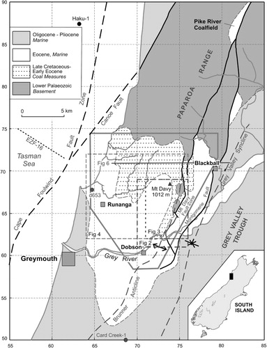
Table 1 The basic stratigraphic sequence (Paparoa Group and Brunner Coal Measures mainly after Gage Citation1952; younger units after Nathan Citation1974). The nomenclature of the sedimentary basins is from Suggate & Waight (Citation1999).
A change to compression during Neogene time resulted in thick deposits accumulating in the Grey Valley Trough to the east of the coalfield; these originally extended to at least the east and west margins of the coalfield. Since Gage (Citation1949, Citation1952) discussed the development of the Grey Valley Trough, drilling and seismic work have shown widespread Late Cretaceous deposits reaching thicknesses similar to those in Greymouth Coalfield; in contrast to Greymouth Coalfield, however, Eocene deposits are thin (Suggate & Waight Citation1999; Suggate Citation2006). Seismic exploration offshore west of Greymouth has shown a Late Cretaceous and Palaeogene sequence comparable with that in Greymouth Coalfield (Suggate Citation2013).
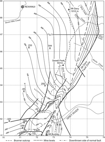
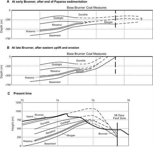
The major structure of the coalfield is the Brunner Anticline which, south of Mount Buckley, plunges to the southwest (). Over the greater part of the coalfield north of the river, erosion has removed most of the coal measures along the crest of the anticline, making it difficult to define. The anticline is the major structure of the Paparoa Inversion Zone, which resulted from the Neogene inversion of the Palaeogene deposits. Gage (Citation1949, Citation1952) inferred that Neogene uplift of the basin was greatest where Late Cretaceous–late Eocene subsidence and deposition had been greatest towards a steep margin adjoining the subsequent Mount Davy Fault Zone (). This relation between subsidence and uplift was called ‘eversion’ by Wellman (Citation1948), who studied the Pike River Coalfield on the crest of the Paparoa Range 20 km north of Greymouth Coalfield (). Gage (Citation1952) accepted that the Brunner Coal Measures clearly marked the Brunner Anticline in the south at Mount Buckley (), and that their presence dipping east into the Mount Davy Fault Zone 6 km to the north at the head of Ruby Creek () showed the need for the anticline to the west. He did not however associate it with the anticline defined by the Morgan Coal Measures that he mapped (Gage Citation1952, map 5/1) less than 1 km to the southwest of the head of Ruby Creek (grid reference 747668).
The delineation and significance of the Brunner Anticline in both the Brunner and Paparoa coal measures in the east of the coalfield are revised after examination of Gage's (Citation1952) field data sheets. Revision of the timing of the development of the Mount Davy Fault Zone and the relations of the Late Cretaceous–Paleocene Greymouth Coalfield Basin to the Eocene Paparoa Trough follow from consideration of the former extent of the Paparoa Group in the east and deformation in the interval between deposition in the Greymouth Coalfield Basin and the Paparoa Trough. A review of Neogene stratigraphy leads to consideration of the possible extent of Neogene deposition over the coalfield and of the timing of inversion of the coalfield sequence. Accordingly, a major alternative to the existing varied concepts of basin development are suggested.
The major structure: the Brunner Anticline
In the Brunner Coal Measures
From 40 km south of the coalfield, the Brunner Anticline extends north to the Grey River; north of the coalfield it is represented by the Paparoa Range (). Within the coalfield south of the Grey River, the anticline is well marked at Mount Buckley () and, judged by drilling in Mill Creek 1.5 km to the southwest, is probably uninterrupted by faults as it continues to the southwest and south. North of the Grey River, Gage (Citation1952, cross-section 3 in map 14) showed the ‘Mt Davy Anticline’ defined by Brunner Coal Measures east of the Mount Davy–Sewell Peak escarpment. On a small scale, Gage (Citation1952, fig. 11), closely followed by Nathan (Citation1978, fig. 11), showed it as discontinuous, cut by the Mount Davy Fault Zone.
In the south of , outcrop data and Brunner Seam mine workings (Gage Citation1952) generally constrain the structural interpretation, with the north end of the dome over Mount Buckley carrying the axis of the Brunner Anticline northwards towards the east of the most easterly mine workings. North of the mines, interpretation is hindered by extensive erosion that has removed the Brunner Coal Measures east of the Mount Davy–Sewell Peak ridge, apart from one key east-dipping area adjoining the Mount Davy Fault Zone north from grid reference 757668 (). The Brunner Anticline thus lies to the west between the fault zone and the Mount Davy–Sewell Peak escarpment from which the Brunner Coal Measures dip to the west. Because of erosion, the axis of the Brunner Anticline cannot be traced north of the area in ; it may, as shown by Gage (Citation1952, fig. 11), converge with the Mount Davy Fault Zone. North of the coalfield, at least as far north as the Pike River Coalfield (), it is represented by the crest of the Paparoa Range, with summit altitudes of c. 1100 m, similar to that inferred for the anticline's crest east of Mount Davy.
In the Paparoa Group
The Paparoa formations crop out along much of the steeply dissected slopes from the Mount Davy–Sewell Peak escarpment east to the Mount Davy Fault Zone, but close to the fault zone erosion has removed most or all of them, exposing substantial areas of Greenland Group basement rocks (). A short length of anticline defined from outcrops of the base of the Morgan Coal Measures was mapped by Gage (Citation1952, maps 5, 5/1) trending north through grid reference c. 747668, almost coincident with the Brunner Anticline in the Brunner Coal Measures (). As shown by drilling, the Paparoa formations in the Mount Davy Block () have a similar pattern of deformation to that of the Brunner Coal Measures. Deformation of the Brunner Coal Measures will have affected Paparoa formations, so that the similarity of the position of the Brunner Anticline in both the Morgan and Brunner coal measures in this area allows the general pattern of Brunner deformation () to be used in developing the likely pattern in the Morgan Coal Measures ().
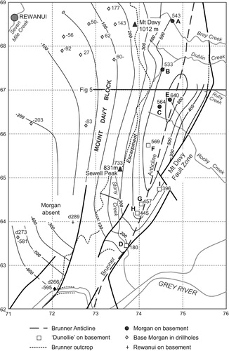
Gage's (Citation1952) stratigraphic interpretation of the Paparoa Group sequence was examined in the context of the difficulty of identifying individual coal measure formations where the intervening mudstone formations are absent. Gage's (Citation1952) maps do not show structural symbols, and his field data sheets were examined for these and for lithological data. Gage (Citation1952, map 5) mapped the Morgan Coal Measures as the basal Paparoa Formation from Bray Creek (A, ) south past Dublin Creek (B, ) to Rocky Creek (C, ) and for a further kilometre to the south where, at the junction of his maps 5 and 8, he mapped the Morgan Formation as following the Waiomo, Rewanui and Goldlight formations in abruptly pinching out, leaving the Dunollie Formation resting on basement. shows the heights of the basal contacts of individual sequences. Using the position and southwards plunge of the Brunner Anticline, the strikes, dips and altitudes of the basal beds at F, G, H and I () are consistent with the basal beds being Morgan Coal Measures rather than Dunollie Coal Measures. Further south at Stony Creek (D, ), the basal Paparoa beds are not exposed but Gage (Citation1952) mapped a sedimentary contact on basement at an altitude consistent with the position of the anticline and with the basal beds being Morgan Coal Measures.
The basis for Gage's (Citation1952) abrupt change of basal Paparoa Formation from Morgan to Dunollie between C and F () seems to derive from the Stony Creek section (D, ), where no easy subdivision of the c. 400 m thick section is possible. Despite this exceptional thickness, Gage (Citation1952) included all in Dunollie Coal Measures. Subsequently, drillhole 289, 1 km to the west (), showed only 185 m of Dunollie Coal Measures underlain by 145 m of Goldlight Mudstone and 102 m of Rewanui Coal Measures resting on basement. This led Suggate (Citation1955) to suggest that in Sony Creek the Goldlight Mudstone had passed laterally into mudstone, shale and fine sandstone. Comparably, a lateral transition from the Waiomo Mudstone recorded in drillhole 266, 1.5 km to the southwest (Gage Citation1952; Suggate Citation1955; ), might be represented by coarser beds in the Stony Creek section. If lateral equivalents of the mudstone formations are present, the basal beds in Stony Creek are likely to be Morgan Coal Measures. The probable representation of lateral equivalents of formations between the Morgan Coal Measures and Dunollie Coal Measures might also apply through the 2.5 km gap between sections B and D in , where Gage (Citation1952, field data sheets) recorded few observations. Although Gage's (Citation1952, map 5) interpretation is mainly used in , for which the cross-section line lies between sections B and D, the pinching out of the Waiomo Mudstone and Rewanui Coal Measures is problematic.
Basin development
Late Cretaceous–Paleocene: the Paparoa Group in the Greymouth Coalfield Basin
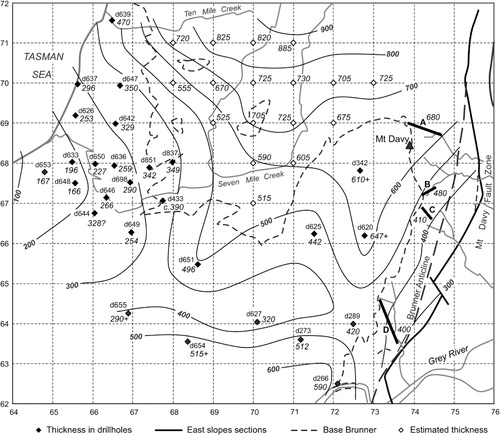
Apart perhaps from the basal conglomeratic member of the Jay Formation, the Paparoa Group () was deposited in the Greymouth Coalfield Basin, in which its thicknesses west of the Brunner Anticline () show major increases northwards and southwards from a thinner zone across the coalfield. Depocentres shifted as deposition progressed, but from the Morgan Coal Measures to the Goldlight Mudstone they were in the central part of the coalfield (Ward Citation1997). In the east, Gage's (Citation1952, figs 5–8) isopachs reflect the present absence of any Paparoa formations other than the Morgan Coal Measures, an absence that was attributed to their pinching out parallel to where the fault zone was to develop. In the east however, the isopachs () are clearly not influenced by the Mount Davy Fault Zone. Further, Raine (Citation1984) has indicated former extension of upper Paparoa Group formations east of Gage's (Citation1952, figs 5–8) zero isopachs by reporting two samples in palynology Zone PM3, which covers the Goldlight Mudstone and Dunollie Coal Measures (including Brunner-P; cf. Nathan et al. Citation1986), from 3 km west of Blackball (). This area was mapped by Gage (Citation1952) as Morgan Coal Measures, unconformably overlain by a small isolated area of Brunner Coal Measures 300 m to the north.
Gage (Citation1952) accepted that ‘gentle movements of elevation caused erosion of the Paparoa beds from east of’ the future Mount Davy Fault Zone prior to deposition of the Brunner Coal Measures. The absence of much of the Paparoa Group east of the fault zone is here attributed mainly to uplift and erosion during the long interval between the end of its deposition and the resumption of continuous deposition at the base of the Rapahoe Group. Rather than the whole Paparoa Group pinching out during deposition, the basin may have continued eastwards across the position of the later Montgomerie Fault into the thick Paparoa Group now at depth in the area of the Grey Valley Trough (Suggate & Waight Citation1999; Suggate Citation2006). In the southwest, the Paparoa Group probably extended west offshore into the Takutai South sequence west of the Cape Foulwind Fault Zone, west of Greymouth (Suggate Citation2013).
Gage (Citation1952, figs 12, 13) did not show any faulting during the whole Late Cretaceous and Palaeogene depositional phase, therefore not recognising the Mount Davy Fault Zone as a major feature until Neogene deformation began. He referred (Gage Citation1952, p. 57) to a ‘downfold’ in which the Late Cretaceous–Eocene deposits accumulated. The Greymouth Coalfield Basin is here interpreted as a downwarping and not fault-angle basin, one of the region's Late Cretaceous–Paleocene Mawhera basins (Suggate & Waight Citation1999; Suggate Citation2013). This interpretation replaces that of an extensional basin with normal faulting at the Mount Davy Fault Zone at its margin, as accepted by Laird (Citation1968), Nathan et al. (Citation1986) and Kamp et al. (Citation1999).
Early Eocene: Brunner Coal Measures
The Brunner Coal Measures accumulated during the long 9–15 Ma interval between the end of Paparoa Group deposition and the beginning of the marine transgression that started Rapahoe Group deposition. ‘Deeply leached Brunner sediments spread across the entire region’, having formed in ‘an environment that permitted chemical decay of the less resistant constituents’ (Gage Citation1952). Although the period was one of little deformation in the greater part of the coalfield, a minor unconformity below Brunner Coal Measures is recorded in the west (Wellman Citation1950) and greater deformation took place in the east. Movements in the east led to a significant unconformity () such as, for example, at the head of Ruby Creek where Brunner Coal Measures rest on Morgan Coal Measures. (Gage Citation1952, map 5).
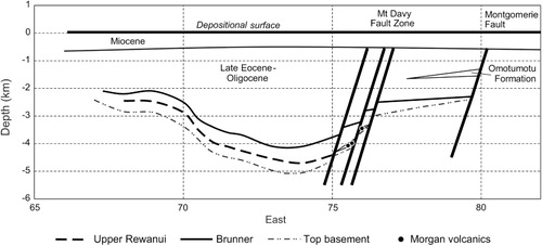
Late Eocene: the Rapahoe Group in the Paparoa Trough, and Oligocene: Cobden Limestone
The Brunner Coal Measures are followed conformably by the Rapahoe Group, deposited in the progressively deepening Paparoa Trough. A thin Rapahoe sequence east of the Montgomerie Fault, as at Garden Gully 7 km NNE of Blackball (), contrasts with a much thicker sequence to the south in the Blackball area west of the fault (Gage & Wellman Citation1945). Further south, a wedge of coarse clastics of the Omotumotu Formation, shed from a rising area east of the fault, thins westwards (; cf. Suggate & Waight Citation1999, fig. 4.6). In the west of the coalfield, the c. 550 m thick Rapahoe sequence northwest of Runanga thickens eastwards to a maximum west of the developing westerly downthrown Mount Davy Fault Zone; the trough margin, however, was at the Montgomerie Fault. Suggate & Boyd (Citation2012) inferred that at Blackwater Creek 1.5 km northeast of Mount Davy, c. 0.5 km of westerly dowmthrow took place at the Mount Davy Fault Zone during Rapahoe Group deposition, and that syndepositional faulting during Rapahoe Group deposition was also indicated by differences in both coal rank and Island Sandstone thickness across the Dobson Fault in the south of the coalfield. The Mount Davy Fault Zone is here regarded as a feature that was initiated within the Paparoa Trough, which was a fault-angle basin bounded on the east by the active Montgomerie Fault. The axis of the trough lay along the line of the later Brunner Anticline (cf. Suggate & Waight Citation1999). The Oligocene Cobden Limestone, thin compared with the Paparoa and Rapahoe groups, was deposited throughout the region, ending deposition in the Paparoa Trough.
Neogene sedimentation and Brunner Anticline uplift timing
Early Miocene: Inangahua Formation and Stillwater Mudstone
Deposition of Cobden Limestone was followed by Inangahua Formation, present at: Greymouth and in the Grey Valley Trough to the east (but absent from Stillwater Creek 4 km ESE of Dobson); in the Card Creek-1 exploration well 10 km south of Dobson (); and between Cobden Limestone and unconformably overlying Stillwater Mudstone across the Brunner Anticline further to the south (Suggate & Waight Citation1999). The former presence of either Inangahua Formation or Stillwater Mudstone across the coalfield remains uncertain however, particularly that of the Inangahua Formation because of the widespread unconformity below Stillwater Mudstone.
Since Gage (Citation1952), it has been generally accepted (e.g. Laird Citation1968; Nathan et al. Citation1986; Kamp et al. Citation1999) that burial of the Greymouth coals was completed at about the end of the Oligocene. Some Neogene sedimentation may however have taken place over the coalfield. North of Dobson in the centre south of the coalfield (), where Suggate & Boyd (Citation2012) estimated a maximum depth of burial of the Brunner Coal Measures of 3 km, the thickness of the Rapahoe Group is c. 2200 m (Suggate & Waight Citation1999, fig. 4.7). Above this the Cobden Limestone reached perhaps 300 m, making a total of c. 2500 m; c. 500 m of Neogene sediments, probably Stillwater Mudstone, are likely to have been deposited there. In the east in the Blackball () area, Gage (Citation1952) estimated the Island Sandstone thickness to be 30–130 m. To the south towards the Grey River, he recorded Kaiata Mudstone as up to 900 m thick but much thinner near Blackball. The Omotumotu Beds, 600–900 m thick near the Grey River, thin northwards towards Blackball to be c. 300 m thick at Kinsella Peak, 2 km southwest of Blackball. In the extreme south, Port Elizabeth Beds are 240 m thick (Nathan Citation1978). In the Blackball area, the total Eocene thickness above the Brunner is therefore likely to have been little more than 1.2 km. The Cobden Limestone and Inangahua Formation together are unlikely to exceed 0.5 km, recorded on the west side of the adjacent Grey Valley Trough (Suggate Citation2006), resulting in a total pre-Stillwater Mudstone thickness of significantly less than 2 km. Coal rank values of c. 9.5 Rank(Sr) (Suggate Citation2000) indicate well over 2 km of post-Eocene cover unless the vertical rank gradient was exceptionally high, so that Stillwater Mudstone was probably also deposited in this area. In the west of the coalfield, the units presently overlying the base of the Island Sandstone in drillhole 653 1.5 km northwest of Runanga (), together with overlying units in the coastal section west to the middle of the Cobden Limestone at Point Elizabeth (Nathan Citation1978), are c. 900 m thick. The depth of burial estimated by Suggate & Boyd (Citation2012, fig. 9B) at d653 is 1800 m, indicating c. 900 m of post-Cobden deposition. In the absence of Inangahua Formation (Nathan Citation1978), this will have been Stillwater Mudstone, of which Nathan (Citation1978) recorded >700 m in the Greymouth area.
Both to the southwest of the coalfield at Greymouth and to the southeast in Stillwater Creek (southeast of Dobson, grid reference 740587), bands of limestone in the lower part of the Stillwater Mudstone are rich in polyzoa, Amphistegina and other large foraminifera (Nathan Citation1978), indicative of similar environments on both sides of the future Brunner Anticline. At Greymouth, the mudstone was deposited in an ‘upper – but not uppermost – bathyal environment’ (Maxwell Citation1988), and there is no evidence of shallow-water deposition such as that which might be expected if the coalfield was emergent. Slumping into the mudstone, carrying boulders of Cobden Limestone (Nathan Citation1978), possibly originated from the north where Cobden Limestone is missing at a Miocene–Eocene unconformity in the offshore Haku-1 well, and is not recognisable in seismic lines for 15 km to the south including line EZF-16 (; Suggate Citation2013). Given the similarity of depositional environments and the depths of deposition on the two sides of the Brunner Anticline at Greymouth and Stillwater Creek, Stillwater Mudstone was probably also deposited across the future anticline there. With Stillwater Mudstone deposition also probable over the east and west sides of the coalfield as detailed above, deposition of the formation across the future anticline is likely over the whole coalfield. The slightly greater thicknesses of Stillwater Mudstone to the east and west than north of Dobson in the axial area of the Paparoa Inversion Zone is attributed to greater subsidence rather than to incipient uplift of the Brunner Anticline.
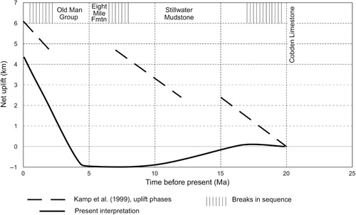
Stillwater Mudstone deposition, which had begun 18–17 Ma ago after a short-lived break in the Paparoa Inversion Zone, ended with an unconformity over the whole region dated from c. 8 to 6.5 Ma (Suggate & Waight Citation1999). Its deposition from 17 to 8 Ma includes the end of a 20–15 Ma period of uplift and almost the whole of a 12–7.5 Ma period of uplift inferred by Kamp et al. (Citation1999) from apatite fission track thermochronology, backed by stratigraphic breaks in the hinge zone between the inversion zone and the Grey Valley Trough. To account for ‘important offsets’ in the timing of the stratigraphic breaks and the inferred phases of uplift (), Kamp et al. (Citation1999) inferred a complex history of stick-slip behaviour across a hypothetical fault along the hinge zone. In considering the history of the axial part of the Paparoa Inversion Zone, including Greymouth Coalfield, the emphasis is better placed on the sequence in the inversion zone than on that in the hinge zone, where breaks are likely to be found.
Brunner Anticline inversion and development timing
In the context of the West Coast region as a whole, Nathan et al. (Citation1986) considered the uplift of the ranges to be essentially a Quaternary episode. A somewhat earlier beginning of uplift of the south end of the Paparoa Range, of which Greymouth Coalfield forms part, can however be inferred. In the Grey Valley Trough, Stillwater Mudstone was followed by the c. 7 Ma Notown Coal Measures, the basal unit of the Eight Mile Formation (Suggate & Waight Citation1999). This contains granite pebbles north of the coalfield, providing the first indication of uplift of the Paparoa Range. Any Cenozoic sediments that may have been deposited on the granite would have been rapidly eroded. Forty kilometres southwest of the coalfield, deposition across the Brunner Anticline, the principal structure of the Paparoa Inversion Zone, continued until 2 Ma or later (Suggate & Waight Citation1999), indicating that inversion progressed southwards. In central Greymouth Coalfield the beginning of inversion is estimated at c. 4.5 Ma, and uplift continues to the present time. During inversion, the Mount Davy Fault Zone and Montgomerie Fault reversed their directions of movement to become reverse faults.
The Brunner Coal Measures at Mount Davy, now at an altitude of 1 km, were originally buried to a depth of 4.5 km (cf. ); they have therefore been uplifted 5.5 km. In the west at drillhole d653, 1.5 km northwest of Runanga and 9 km west of Mount Davy (), the Brunner was buried to a depth of 1.8 km (Suggate & Boyd Citation2012) and is now at 0.4 km below sea level, having been uplifted 1.4 km, 4.1 km less than at Mount Davy. Rates of this late Quaternary deformation led to estimates of the approximate duration of uplift across the coalfield. On the north side of the Grey River west of Dobson, Grey Valley terraces of probable Last Interglacial age (0.125 Ma; Nathan et al. Citation2002) – consequently likely to have been formed with a river gradient as low as at present – now rise eastwards at c. 0.01 km km–1 more than the river. At this rate, and assuming a uniform uplift rate over this short time period, the 4.1 km difference in uplift over the 9 km from Mount Davy to d653 would have taken 5.7 Ma. At d653, where the Brunner Coal Measures have been uplifted 1.4 km, the rate of uplift of nearby raised beaches was estimated at c. 0.4 km Ma–1 (Suggate Citation1992); at a similar rate the 1.4 km uplift of the Brunner Coal Measures would have taken 3.5 Ma. These estimated late Quaternary uplift rates support stratigraphy in indicating that the whole uplift took place since the uppermost Miocene, or perhaps later, contrasting with the conclusions of Kamp et al. (Citation1999) ().
Discussion and conclusions
The Paparoa Group was deposited in the Greymouth Coalfield Basin, one of the Late Cretaceous–Paleocene Mawhera Basins of onshore and offshore Westland. The basin extended south for >50 km past Koiterangi Hill and north for 80 km past Pike River Coalfield () to the Te Kuha Sector at the south end of Buller Coalfield (Dutton et al. Citation2013). This 130+ km extent is greater than the 90 km from Te Kuha to the Collingwood Coalfield where the Pakawau Group is linked directly with the Late Cretaceous sequences of the Taranaki Basin. The Greymouth Coalfield Basin may also have been originally joined to other Mawhera Basins now at depth to the southeast in the Grey Valley Trough (Suggate & Waight Citation1999) and to the southwest in the offshore Takutai sequence (Suggate Citation2013). Although the full regional extent of Late Cretaceous deposition is unknown, it could have covered the whole of the northwest of the South Island and far offshore.
The basin has an apparent north-western boundary in Greymouth Coalfield, but Gage's (Citation1952) abrupt eastern boundary is rejected as a depositional feature, partly as a result of revision of the structure and stratigraphy across the crest of the Brunner Anticline and partly because the Brunner Coal Measures overlie the Paparoa Group unconformably. The Paparoa Group was thickest in the north, with a thinner belt towards the south before thickening again further south. There was no Mount Davy Fault Zone, and the previous model of a fault-angle depression (extensional half-graben) is replaced by that of an extensional downwarping basin.
Following widespread erosion resulting from uplift in the east and minor movement in the west, a major change in environment led to the regionally widespread slowly accumulating Brunner Coal Measures. In the south, movement began on the Dobson Fault, indicative of early extension in a regime that lasted until early Oligocene time. The Eocene Rapahoe Group deposited in the Paparoa Trough thickened eastwards to the active Mount Davy Fault Zone, but the margin of the trough lay further east at the Montgomerie Fault which bounded a fault-angle depression that extended west across the coalfield. South from Blackball, a westwards-thinning wedge of coarse sediments resulted from uplift east of the fault. The Paparoa Basin is matched 80 km to the north by the Westport Trough, in which Buller Coalfield lies (Laird Citation1968; Kamp et al. Citation1999), by comparable depositional episodes in Reefton coalfields (Suggate Citation1957) and in the west of the Murchison basin (Roder & Suggate Citation1990). The similar timing of basin initiation across all these areas supports the identification of the Paparoa Trough as distinct from the preceding Greymouth Coalfield Basin, rather than being its reactivation.
During middle–late Oligocene time, Cobden Limestone extended regionally at a time of little tectonic activity or sedimentation before another depositional episode started during early Miocene time. Stillwater Mudstone, thick in the Grey Valley Trough, extended across the Paparoa Inversion Zone (of which the Brunner Anticline is the major structure) north to at least the southern part of the coalfield, and is accepted as having covered the whole coalfield. A short time break marked by a late Miocene unconformity extended over the whole region although, as a result of deformation and erosion, it is now only recorded across the Brunner Anticline well south of the coalfield. Inversion marked by uplift of the anticline began north of the coalfield, extending to the coalfield soon afterwards. In the coalfield itself, inversion of the Rapahoe Group, carrying with it the underlying Paparoa Group and overlying Stillwater Mudstone, began c. 4.5 Ma ago rather than taking place intermittently during Neogene time. Since then, uplifts of late Quaternary deposits in the west of the coalfield are at rates comparable with those of Brunner Coal Measures from there to Mount Davy. Most of the complex folding and faulting in the coalfield took place during inversion.
Acknowledgements
Simon Nathan and Steve Edbrooke (GNS Science) provided valuable comments on an early version of the manuscript. The comments of referees are gratefully acknowledged. Carolyn Hume (GNS Science) drew the figures.
References
- Bishop DJ, Buchanan PG 1995. Development of structurally inverted basins: a case study from the West Coast, South Island, New Zealand. In: Buchanan JG, Buchanan PG eds. Basin inversion. Geological Society Special Publication 88: 549–585.
- Dutton A, Newman N, Newman J, Pope J, Field A 2013. The Te Kuha Sector, Buller Coalfield: a revised model. Australasian Institute of Mining and Metallurgy New Zealand Branch Annual Conference 2013 Proceedings. Alexandra, Otago, AusIMM –The New Zealand Branch. Pp. 119–129.
- Gage M 1949. Late Cretaceous and Tertiary geosynclines in Westland, New Zealand. Transactions of the Royal Society of New Zealand 77: 325–337.
- Gage M 1952. The Greymouth Coalfield. New Zealand Geological Survey Bulletin 45. 69 p.
- Gage M, Wellman HW 1945. Age revision of Tertiary sediments at Garden Gully and Fitzgerald Creek, near Blackball, Westland. Transactions of the Royal Society of New Zealand 75: 357–363.
- Kamp PJJ, Whitehouse IWS, Newman J 1999. Constraints on the thermal and tectonic evolution of Greymouth coalfield. New Zealand Journal of Geology and Geophysics 42: 447–467.
- Laird MG 1968. The Paparoa Tectonic Zone. New Zealand Journal of Geology and Geophysics 11: 435–454.
- Maxwell PA 1988. Late Miocene deep-water Mollusca from the Stillwater Mudstone at Greymouth, Westland, New Zealand. New Zealand Geological Survey Paleontological Bulletin 55.
- Nathan S 1974. Stratigraphic nomenclature for the Cretaceous–Lower Quaternary rocks of Buller and north Westland, West Coast, South Island, New Zealand. New Zealand Journal of Geology and Geophysics 17: 423–445.
- Nathan S 1978. Sheet S44–Greymouth. Geological map of New Zealand 1: 63360. Wellington, Department of Scientific and Industrial Research.
- Nathan S, Anderson HJ, Cook RA, Herzer RH, Hoskins RH, Raine JI et al. 1986. Cretaceous and Cenozoic sedimentary basins of the West Coast, South Island, New Zealand. New Zealand Geological Survey basin studies report 1. Wellington, SIPC, DSIR. 89 p.
- Nathan S, Rattenbury MS, Suggate RP 2002. Geology of the Greymouth area. Institute of Geological and Nuclear Sciences 1:250 000 geological map 12. Lower Hutt, GNS Science.
- Raine JI 1984. Outline of palynological zonation of Cretaceous to Paleogene terrestrial sediments in West Coast region, South Island, New Zealand. New Zealand Geological Survey Report 109. 82 p.
- Roder GH, Suggate RP 1990. Sheet L29BD-Upper Buller Gorge. Geological map of New Zealand 1:50 000. Wellington, Department of Scientific and Industrial Research.
- Suggate RP 1955. Deep drilling for coal – Brunner-Mount Davy Block, Greymouth Coalfield, New Zealand. New Zealand Journal of Science and Technology B37: 86–105.
- Suggate RP 1957. The geology of Reefton Subdivision. New Zealand Geological Survey Bulletin 56.
- Suggate RP 1992. Differential uplift of Middle and Late Quaternary shorelines, northwest South Island, New Zealand. Quaternary International 15/16: 47–59.
- Suggate RP 2000. The Rank(Sr) scale. Its basis and its application as a maturity index for all coals. New Zealand Journal of Geology and Geophysics 43: 521–553.
- Suggate RP 2006. The northern Grey Valley Trough and the Montgomerie Fault, north Westland, New Zealand. New Zealand Journal of Geology and Geophysics 49: 491–502.
- Suggate RP 2013. Late Cretaceous and Paleogene stratigraphy and structure linking offshore with onshore north Westland. New Zealand. New Zealand Journal of Geology and Geophysics 56: 263–275.
- Suggate RP, Boyd RJ 2012. Vertical coal rank gradients, depths of burial and paleotemperatures. New Zealand Journal of Geology and Geophysics 55: 111–126.
- Suggate RP, Waight TE 1999. Geology of the Kumara-Moana area. Institute of Geological and Nuclear Sciences geological map 24. Lower Hutt, GNS Science.
- Ward SD 1997. Lithostratigraphy, palynostratigraphy and basin analysis of the Late Cretaceous to early Tertiary Paparoa Group, Greymouth Coalfield, New Zealand. Unpublished PhD thesis. Christchurch, University of Canterbury.
- Wellman HW 1948. Geology of the Pike River Coalfield, north Westland. New Zealand Journal of Science and Technology B30: 84–95.
- Wellman HW 1950. Paparoa-Brunner unconformity near Greymouth. New Zealand Journal of Science and Technology B32: 9–17.