
Abstract
Gold-bearing beaches at the western end of Foveaux Strait are being fed by the Waiau River, which is dominated by greywacke detritus. At times during the Pleistocene, debris from crystalline rocks in Fiordland has fed the Foveaux Strait beaches, and the greywacke detritus was diverted farther east. In contrast, the Round Hill placer goldfield has been dominated by locally derived fluvial felsic and mafic debris in the late Pleistocene to Recent. Gold particles in the Round Hill goldfield are toroidal in shape, and have been recycled from older beach sediments. Some gold toroids on active beaches may have been recycled from older beach sediments as well, whereas some may have formed in situ. Most gold toroids have encrustations of polymorphic clays and bio-organic matter, locally impregnated with fine-grained authigenic gold, and some toroids hosted in fluvial sediments display delicate authigenic gold overgrowths as a result of the biogeochemical transformation of gold. These biogeochemical processes appear to have little effect on co-existing detrital platinum group minerals such as isoferroplatinum.
Introduction
Detrital gold concentrations in placer deposits have been economically important in the southern South Island for > 150 years, and exploration and mining of these placer gold deposits is ongoing (Macpherson Citation1937, Citation1938; Williams Citation1974; Falconer et al. Citation2006; Falconer & Craw Citation2009; Craw Citation2013). These placer deposits occur in a wide range of sedimentary settings, both fluvial and marginal marine, and formed at different times between the Miocene and the Holocene (Macpherson Citation1937, Citation1938; Williams Citation1974; Falconer et al. Citation2006; Craw Citation2013; Craw et al. Citation2013). Detrital gold is remarkably persistent in the sedimentary record through tectonic uplift, erosion and sedimentary recycling events that have been the geological norm in the region since the middle Cenozoic, and the gold is readily transported and reconcentrated downstream (Macpherson Citation1937; Falconer et al. Citation2006; Youngson et al. Citation2006; Craw Citation2013; Craw et al. Citation2013). Understanding these sedimentary recycling events, and the associated detrital gold redistribution, is important for exploration and characterisation of the placer deposits, and for deducing the source(s) of the detrital gold.
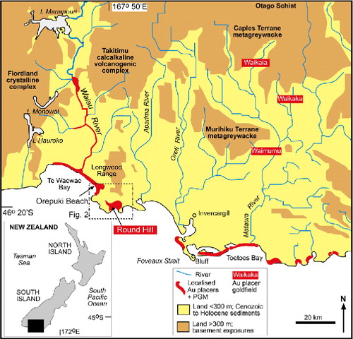
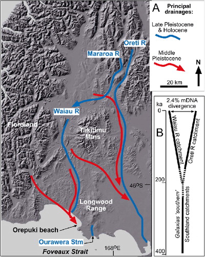
There are two principal detrital gold transport and recycling pathways in the southern South Island: through eastern Southland, and through the Waiau River system in the west (). The eastern pathway originated during Miocene fluvial drainage southwards from Otago Schist gold sources, and subsequent recycling has redistributed detrital gold in the Waikaia, Waikaka and Waimumu placer goldfields (; Macpherson Citation1937; Williams Citation1974; Falconer et al. Citation2006; Falconer & Craw Citation2009; Craw Citation2013). Most post-Miocene gold redistribution has involved proximal transport and localised concentration in nearby younger fluvial sediments, and redistribution into modern streams.
The western detrital gold transport pathway is little understood, and therefore is the subject of this study. The ultimate source(s) of detrital gold in the western pathway is not known, and neither is the Cenozoic–Holocene recycling history for that gold, although there have been numerous uplift and erosional events that have affected basement and overlying sediments (Craw et al. Citation2013). Unlike the placers in the eastern pathway, the western placers include small, but not inconsiderable amounts of platinum group minerals (PGM) from unknown sources (Craw et al. Citation2013). The presently known fluvial component of the western detrital gold transport pathway is confined to the Holocene Waiau River bed (; Craw et al. Citation2013). Most of the placer deposits occur in Pleistocene–Holocene marginal marine sediments along the southern coast of the South Island, and this is where most historic mining has been located (; MacPherson Citation1938; Wood Citation1969; Douglas Citation1986; Craw et al. Citation2013). Here, we focus on the nature, sources and local recycling of the Pleistocene and Holocene sediments that host the placer gold and PGM, rather than the ultimate basement sources of these metals. We use these observations to elucidate paleogeographic changes that have occurred in the southern part of the western pathway during that time, in order to understand the younger part of the gold redistribution history. We focus in particular on the area near the Round Hill placer gold mine (–), because this has been the largest and most persistent mine site in the area (MacPherson Citation1938; Douglas Citation1986; Craw et al. Citation2013).
General setting
The Waiau River valley () is a long-lived structural depression that has been accumulating sediments since the Eocene (Norris et al. Citation1978; Turnbull & Allibone Citation2003). Sedimentation was marine between late Eocene and Miocene, and then regional uplift caused a transition to fluvial environments from the late Miocene to present (Norris et al. Citation1978; Turnbull & Allibone Citation2003). The valley is now flanked by ridges of uplifted basement rocks that are shedding debris into the Waiau River, which drains an extensive region to the north that includes Mesozoic Caples Terrane metagreywacke (). The western side of the Waiau depression consists of Paleozoic to Mesozoic crystalline rocks of Fiordland, including high-grade (amphibolite-granulite facies) metamorphic rocks and a wide range of plutonic intrusions, dominated by granitoids (Turnbull et al. Citation2010). The eastern side of the depression is defined by broad mountain ranges made up of Permian Brook Street Terrane rocks (; Mortimer et al. Citation1999; Turnbull & Allibone Citation2003). This terrane includes abundant calcalkaline volcanogenic sedimentary rocks, including greywackes, and associated mafic flows and shallow intrusions (Mortimer et al. Citation1999; Turnbull & Allibone Citation2003). The Takitimu Mountains consist entirely of these rock types, whereas the Longwood Range, extending to the south coast (–) consists mainly of gabbroic and felsic plutons that were intruded in to these dominantly sedimentary host rocks during the Permian (; Mortimer et al. Citation1999; Turnbull & Allibone Citation2003; Ashley et al. Citation2012).
Pleistocene glaciers, sourced predominantly from Fiordland, extended into the Waiau depression and periodically filled much of the depression with ice (Turnbull et al. Citation2010). These glaciers deposited tills from which outwash rivers flowed down the Waiau valley and, periodically, to the east of the Takitimu Mountains from the region to the north of Lake Manapouri (Turnbull & Allibone Citation2003; Craw et al. Citation2007). The last major glaciation event, c. 20 ka, left till deposits at their farthest extent between Lake Manapouri and Lake Monowai (; Turnbull & Allibone Citation2003; Turnbull et al. Citation2010). During these glacial events, lower sea levels exposed Foveaux Strait to subaerial processes, during which the Waiau River flowed southward down the continuation of the structural depression, and rivers to the east of the Longwood Range flowed to the southeast (Cullen Citation1967; Turnbull & Allibone Citation2003; Craw et al. Citation2007). Ongoing regional uplift has progressively raised Pleistocene beaches and wave-cut terraces along the coast of Foveaux Strait (Ward Citation1988; Turnbull & Allibone Citation2003).
Placer gold deposits occur in the lower Waiau River valley (), where they are hosted in fluvial gravels that are dominated by greywacke cobbles and sand derived from the Takitimu Mountains and the Caples Terrane, with only a minor contribution from Fiordland crystalline basement (Craw et al. Citation2013). These placer deposits are small and highly localised, in the modern river and adjacent terraces. Placer deposits in marginal marine sediments, predominantly beach sands, have been more important for historic mining (MacPherson Citation1938; Wood Citation1969; Douglas Citation1986; Turnbull & Allibone Citation2003). These deposits occur along the coast of Foveaux Strait, at and near the present shoreline and in uplifted beach terraces (MacPherson Citation1938; Wood Citation1969; Douglas Citation1986; Turnbull & Allibone Citation2003). Overall production has been modest (< 200 koz or c. 6000 kg), but sporadic mining activity has occurred since 1868 (MacPherson Citation1938; Wood Citation1969; Williams Citation1974; Douglas Citation1986).
Platinum group minerals occur as a minor component in the gold placers, in both the Waiau River and the downstream marginal marine deposits along the south coast (; MacPherson Citation1938; Wood Citation1969; Williams Citation1974; Craw et al. Citation2013). The ultimate origin of the PGM is unknown but may include the Longwood Range and ophiolitic rocks to the north of Lake Manapouri (; Craw et al. Citation2013). The distinctive presence of PGM indicates that Waiau River-derived heavy minerals, including gold, occur on numerous beaches along Foveaux Strait (). Placer accumulations have developed during marginal marine transport processes from the Fiordland margin, on the western side of the Waiau valley, southeastwards for >100 km (; Craw et al. Citation2013). This coastal transport has been facilitated by strong prevailing wind and ocean current from the west or southwest through Foveaux Strait (Craw et al. Citation2013). The relative contributions to the farthest southeastern placers of detrital gold from the Waiau River, and from the rivers along the eastern pathway (e.g. down the Mataura River, ), are unknown.
Samples and methods
This study was initiated as an outgrowth of a gold exploration project run by Glass Earth Gold Ltd in the vicinity of the Round Hill placer gold and platinum mine (). The exploration project included some attempts to trace the continuity of placers at depth using a magnetometer, on the assumption that gold becomes concentrated with other heavy minerals including magnetite. A question that arose during this project concerned the validity of this assumption in the Round Hill area, and this study addresses that question in the context of varying sediment sources and their associated heavy mineral components. In particular, we examine the relative amounts of magnetite and the other principal iron-rich heavy mineral, ilmenite, which is relatively non-magnetic, using semi-quantitative chemical analyses and magnetic susceptibility measurements. We use these methods to contrast the relationships between the gold, ilmenite and magnetite contents of fluvial sediments of the Round Hill placer mine area with heavy mineral concentrations in nearby active beach sediments.
An additional question related to placer exploration in the area involves the source(s) of the gold, and to a lesser extent the platinum, within the Pleistocene geological history of the area. To this end, this study examines the morphology of the gold and isoferroplatinum grains in the context of that Pleistocene history. During this morphological study, it became apparent that there has been some authigenic gold addition to the exterior of gold particles, so the water chemistry and other associated authigenic minerals also became relevant to the study, and are documented herein.
The Glass Earth Gold investigations included a substantial drilling programme in the Pleistocene sediments downstream of that mine, in the lower Ourawera Stream (). Samples from that drilling programme provided the basis for much of this research. Further field work and sampling was conducted in Pleistocene and Holocene sediments farther to the northwest, to provide a mineralogical context in which to examine the samples from the Round Hill placer mine area. This additional sampling focussed on the Waiau River and Orepuki Beach (–).

Forty-two drillholes were emplaced in the Round Hill area, and these extended through the Pleistocene–Holocene sediments to basement. The drillholes were typically between 10 and 20 m deep, with the deepest one extending to 33 m. Cross sections through the western edge of the sediment package () were constructed from drillhole depth data, with these depths projected into the lines of section from the nearest drillholes. Hence, the underlying basement profiles in are only approximate, but reflect the general structure of the sediment-filled depression. These sections were augmented with observations on drillhole depths from Douglas (Citation1986).
Samples of each metre of sediment were taken from the drillholes, mostly for extraction of detrital gold, with c. 100 g reserved for mineralogical observations. Gold from a known weight of sediment was extracted by gravitational settling in a slurry, and weighed to produce an average grade for each metre section. In total, 830 samples were processed in this manner.
Gold typically occurs with other heavy minerals that are commonly iron-rich, such as magnetite and ilmenite. Magnetic susceptibility, as a general indicator of magnetite content, was determined on each 100 g subsample drillhole sample in the laboratory with a Bartington portable meter, using the average of three measurements across the subsample container. To further quantify the heavy mineral contents in the sediments, each subsample was subjected to analysis by an Innov-X Systems XPD-4000 hand-held X-ray fluorescence (XRF) instrument, using methods described by Haffert & Craw (Citation2009). Analyses were carried out in a laboratory on samples that had been dried for up to one week, and the dried surfaces of the samples were smoothed before analysis. The instrument can only detect elements heavier than sulfur, and detection limits for trace elements such as Ni and Cr are commonly high and variable (up to several hundred ppm). Hence, for this study we focused on Fe and Ti because they were the principal elements in the dominant heavy minerals. The XRF instrument overestimates Fe and Ti contents above c. 1 wt%, and these results were corrected using pure magnetite, rutile and ilmenite as calibration standards. Results are semiquantitative, but provide useful relative data for comparison of different sediments.
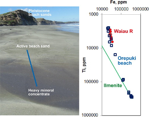
Further handheld XRF analyses of Fe and Ti were conducted in the field on sediments at Orepuki Beach and Waiau River. The Waiau River analyses were conducted on dry river sand on a gravel bar in the active river bed, c. 10 km upstream of the river mouth (). The Orepuki Beach analyses were conducted on the active beach at low tide on a warm sunny day (), so that the upper surface was dry but the sediments remained damp more than 2 mm below the surface. Magnetic susceptibility measurements were also obtained on the Waiau River and Orepuki Beach sediments in the field, using the same portable meter as was used in the laboratory.
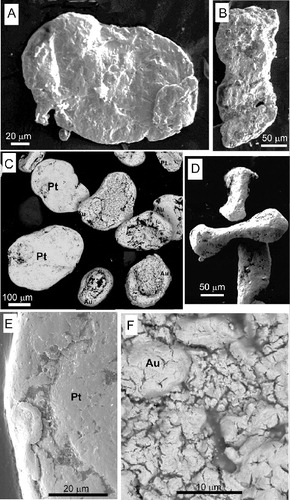
Representative material from the field localities and a range of distinctive drillhole sub-samples were examined with a stereoscopic microscope for mineral identification. Some of this material was also made into polished grain mounts for further microscopic mineral identification (). Heavy mineral concentrates of Waiau River and Orepuki Beach sediments were made in the field with a gold pan, and samples of these concentrates were examined with a stereomicroscope and also made into polished sections to identify minerals (). Clay-rich material was identified with X-ray diffraction using wet smears mounted on a glass slide. Gold particles were mounted on carbon tape and examined with a scanning electron microscope to define morphological characteristics, and to identify any intergrown minerals with energy dispersion X-ray analysis, at the Otago Centre for Electron Microscopy, University of Otago and University of Adelaide.
Table 1 Summary of principal constituents and properties of Pleistocene–Recent sediments relevant to placer gold in the Foveaux Strait area, western Southland.
Surface waters were sampled in clean plastic containers from Ourawera Stream and abandoned mine ponds in the lower Ourawera catchment. Water pH was measured in the field with a portable Oakton meter calibrated with standard solutions. The waters were analysed by Hill Laboratories, Hamilton, New Zealand, after filtration (0.45 µm). Total alkalinity was determined by titration and other major ions were determined by standard methods using inductively coupled plasma mass spectrometry (ICP-MS), colorimetry and ion chromatography.
Lower Waiau River and Orepuki Beach detrital minerals
The modern lower Waiau River is dominated by greywacke debris from the Caples Terrane and the Takitimu Mountains (). Argillaceous and volcanic clasts from these sources form a minor component. Cobbles of these rock types are readily recognisable in gravel bars and on the shores of Te Waewae Bay. River sands, including those analysed in the field, are dominated by greywacke rock fragments, and heavy minerals are rare (). Subordinate coarse (> 100 µm) muscovite and biotite flakes form a conspicuous component of river sands, and minor quartz, plagioclase and orthoclase grains (< 10 vol.% combined) are present also. Garnet is rare or absent from samples examined in this study. Magnetite is the most common heavy iron mineral, and the sediment magnetic susceptibility is moderate (c. 500 × 10−5 SI units). Iron content of river sand, c. 3 wt%, is approximately 10 times greater than Ti content ().
These greywacke-rich sediments persist along the shore of Te Waewae Bay to Orepuki Beach, and form most of the sediment on the active beaches (). The proportion of cobbles decreases rapidly towards the southeast from the Waiau River mouth, and greywacke-rich sand predominates. The proportion of quartz and feldspars is slightly higher than in the Waiau River sands (c. 15 vol.% combined), with quartz predominating in this fraction. Red garnet, magnetite and ilmenite are common constituents in the beach sands, and these form abundant and rich red to black heavy mineral concentrates on the beach surface, in layers up to 20 mm thick (). The bulk of the beach sands have almost identical Fe and Ti contents, and magnetic susceptibilities, to the Waiau River sands (; ). However, some of the heavy mineral concentrates have > 20 wt% Fe and Ti, reflecting highly localised concentration of magnetite and, particularly, ilmenite (). The transect across a transition from greywacke-rich beach sand to heavy mineral concentrate in , which was quantified with handheld XRF, shows a trend towards dominantly ilmenite-rich compositions.
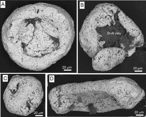
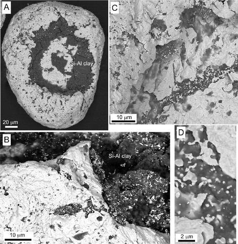
Detrital gold in the Waiau River is highly flattened, flaky and irregular in shape, and these morphological characteristics persist on the Te Waewae Bay beaches adjacent to the river mouth (). There is dramatic transformation in gold particle shapes along the beach to the southeast, where gold occurs primarily in heavy mineral concentrates, as at Orepuki Beach (). Orepuki Beach gold is largely toroidal in shape (). The transformation from flakes to toroids has been documented in more detail by McCann & Craw (Citation2009) and Craw et al. (Citation2013). These studies attributed the shape changes to physical hammering and distortion (peening) of flake edges by wind-driven sand-blasting on exposed beach surfaces. Similar but less pronounced processes affect PGM (McCann & Craw Citation2009; Craw et al. Citation2013), as depicted in . Gold and PGM particles remain separated, and do not wrap around each other. Even irregular and elongate detrital gold has been affected by the peening process, yielding dumbbell-shaped particles with delicate protrusions on their ends (). The interior of toroidal gold particles almost invariably contains polymorphic clay-rich encrustations that include a substantial bio-organic component, including prokaryotic cells (). Some of that polymorphic material contains intergrown nano- and micro-particulate authigenic gold (). Locally, irregular cavities with deeply etched pits, cracks and valleys in gold toroid surfaces () are probably dissolution features.
Pleistocene beach sandstone deposits are preserved in uplifted terraces, up to 20 m above sea level, along the Te Waewae Bay coastline near Orepuki (). In contrast to the greywacke-dominated sands of the active Waiau River and Te Waewae Bay beaches, the sandstones that form these Pleistocene deposits, where exposed in beach cliffs, are dominated by quartz and feldspar, and greywacke rock fragments are generally absent (). The feldspars include both plagioclase and orthoclase, although orthoclase is variably clay-altered. The beach sandstones are partially cemented by abundant white clay, some of which is kaolinite, and some of which is X-ray amorphous but may be poorly crystalline kaolinite. At least some of this cementing clay has been derived by in situ alteration of detrital feldspar. The heavy mineral suite within these sands is dominated by red garnet and ilmenite, with minor magnetite. These minerals are sparsely distributed through the beach deposits, although some centimetre-scale horizons are slightly darker in colour and contain greater heavy mineral components. However, Fe, Ti and magnetic susceptibility are all distinctly lower than in the Waiau River and typical Te Waewae Bay beach sands (). Despite this, it is ongoing erosion of these Pleistocene beach sandstones that constitutes the principal source of garnet and ilmenite in the nearby active beach sediments and their heavy mineral concentrations ().
Ourawera Stream sediments
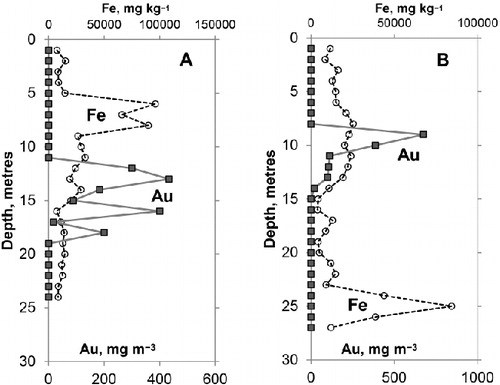
The Ourawera Stream rises c. 10 km from the sea in the mafic and felsic rocks of the Longwood Range basement, and flows southwards to a coastal plain (). The Round Hill placer gold mine was developed at the boundary between basement and the Pleistocene–Holocene sediments of the coastal plain (). Downstream of the mine, the coastal plain has a low gradient, falling < 20 m over 5 km from the mine to the sea. Tailings from the mine were deposited on the surface of the plain in the lower Ourawera Stream, further limiting the stream gradient, and mine development was inhibited at times by tailings accumulation and associated drainage issues (Douglas Citation1986). Beneath the surficial coastal plain sediments, the basement unconformity defines steeper and more irregular paleotopography (). In particular, the paleo-Ourawera stream bed apparently extended below present sea level, probably > 50 m below as projected from the available drillhole data ().
Sediments that underlie the modern Ourawera Stream are fluvial and/or marginal marine in origin, and have apparently been derived directly from the adjacent Longwood Range (Douglas Citation1986; Craw et al. Citation2013). These sediments are mineralogically distinct from any of those described above, as they are dominated by mafic rock fragments (). These include gabbroic and felsic boulders and cobbles that occur in the proximal sediments in and near the Round Hill gold workings, especially near their base (MacPherson Citation1938; Douglas Citation1986), and sporadically in the more distal sediments farther to the south. However, most of the sediments recovered in drillholes are dominated by sand, ranging from sandy silt to very coarse sand, with some fine gravel horizons. Woody organic debris is common throughout the pile, as scattered fine fragments and larger (up to 10 cm) intact pieces.
Sediment mineralogy and chemistry
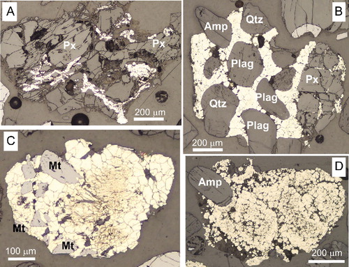
Sand and gravel clasts are predominantly angular to subrounded mafic and felsic rock fragments, and mafic minerals such as calcic plagioclase, hornblende, and pyroxene (). Sand clasts of greywacke rock fragments are present but subordinate, and some of these are more rounded than the angular mafic clasts. Heavy minerals include magnetite and ilmenite, with minor zircon, but no garnet was seen in any samples examined in detail in this study.
The Fe and Ti contents of the drillhole sediments are extremely variable, compared to the active Waiau River and typical Te Waewae Bay beach sands (; ). Some horizons approach the Fe levels of the Orepuki Beach heavy mineral concentrates, most have broadly similar Fe levels to those active sediments, and many have much lower Fe contents (). The Fe contents vary widely on the metre scale, with pronounced spikes that reflect localised heavy mineral accumulations (). Some, but not all, of these Fe-rich heavy mineral accumulations contain abundant magnetite. The magnetic susceptibilities of the sediments are highly variable, reflecting the highly variable contents, and local absence, of magnetite (). The magnetic susceptibilities of most Ourawera Stream sediments are lower than those of active Waiau River and Te Waewae Bay beach sands (). Many of the Ourawera Stream sediments have relatively high Ti contents, and there are some very high Ti contents that are comparable with Orepuki Beach heavy mineral concentrates (). The spread of Fe and Ti data is subparallel to the ilmenite dilution line, reflecting the abundant but apparently variable proportions of ilmenite in the sediments ().
Sediments from drillholes are variably oxidised, especially in the upper 5 m, but deeper sediments are grey and unoxidised. Feldspar and some mafic mineral clasts, especially pyroxene, have been incipiently altered to clay minerals along cleavages. The basement beneath the sediments is generally soft and clay-altered. Some grey unoxidised sediments, especially coarse sands and fine gravels, have clast coatings and incipient cementation by authigenic pyrite. The details and extent of pyrite cementation have been obscured by disaggregation during drilling, but some remnants of pyrite textures are preserved (). The pyrite is fine grained (c. 10–20 µm) and anhedral, although cubic grains occur as well (). Pyrite has penetrated along cleavages and fractures in some clasts, and has filled pore spaces between clasts (). Larger (up to 1 mm) masses of pyrite have pervaded fine-grained matrix and filled voids in the sediments ().
Detrital gold
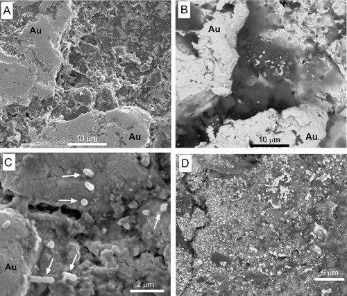
Detrital gold in the Ourawera Stream sediments occurs in layers with a range of sedimentary particle sizes, from fine sand to coarse sand and fine gravel. The detrital gold is generally toroidal in shape (), with some toroids so well developed as to produce spherical particles (). Rare non-toroidal particles are well rounded with smooth surfaces (). Depressions in gold particle surfaces are commonly filled with fine-grained (sub- µm) polymorphic encrustations that include bio-organic material and mineral matter which energy-dispersion SEM analysis shows to include Si–Al clay, possibly kaolinite, without other cations. Authigenic gold overgrowths have formed on many detrital particles and associated clay-rich polymorphic encrustations (). This authigenic gold occurs as nano- and micro-particles scattered across and through the encrustations () and buds, plates and microparticles on gold particle surfaces (). The addition of authigenic gold has made many smooth detrital surfaces distinctly rougher and more irregular at the µm scale.
Detrital gold is enriched in Ourawera Stream sediments with moderate Fe contents, but not in the most Fe-rich sediments (, ). This is in strong contrast to the active Orepuki Beach sediments, where almost all the gold has accumulated in the Fe-rich heavy mineral concentrate layers (). In addition, the highest detrital gold contents in Ourawera Stream sediments occur in layers that have relatively low magnetic susceptibilities of 10–1000 × 10−5 SI, with maximum gold coinciding with magnetic susceptibilities < 100 × 10−5 SI (). This is in strong contrast to the auriferous Orepuki Beach heavy mineral concentrates, which have magnetic susceptibilities > 1000 × 10−5 SI ().
Water chemistry
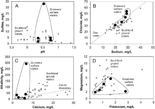
The occurrences of authigenic gold, pyrite and clay in the Ourawera Stream sediments imply that there have been significant chemical water–rock interactions during groundwater percolation. Hence, we have attempted to quantify the chemical nature of the water within the sedimentary pile by analysing waters from the Ourawera Stream and a range of swampy ponds on the coastal plain, within the mine tailings and in the immediate vicinity of the drillholes (). The waters have near-neutral but slightly acidic pH and low to moderate sulfate contents (). Sodium and chloride contents are low to moderate, with Na: Cl ratios similar to those of seawater (). Calcium contents and alkalinities are generally very low, although one sample had strongly elevated alkalinity that is not related to the dissolution of calcite (). Potassium and magnesium concentrations are very low ().
Discussion
Relationships between gold and other heavy minerals
In the active beach placers, a close relationship exists between gold and ilmenite–magnetite concentrations (, ). The magnetite in these heavy mineral concentrates ensures that the gold-rich beach placers have elevated magnetic susceptibilities (), which may be detectable geophysically, although the magnetic contrast is only c.2000 vs c.500 × 10−5 SI units (). The generally high ilmenite contents of these beach placers explain the relatively subdued geophysical signal of these beach placers compared with magnetite-rich placers. The geophysical signal may be further attenuated if the placers are older and buried by other Pleistocene sediments, as in the uplifted beach deposits along the Foveaux Strait coast ().
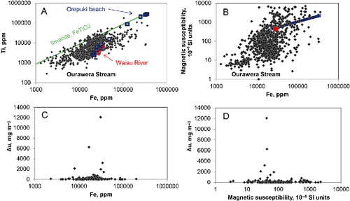
The fluvial sediments of the Ourawera Stream catchment display much weaker relationships between gold and magnetite–ilmenite concentrations (). Few of the analysed Ourawera sediments had Fe contents > 10 wt% (), and there is only minor gold enrichment in the most Fe-rich sediments (, ). Likewise, the magnetic susceptibility of gold-bearing Ourawera sediments is generally lower than those of the beach placers, and the most gold-rich Ourawera sediments have values of < 100 × 10−5 SI units (). The gold-rich Ourawera sediments are generally enriched in Fe-bearing minerals (, ), but these are predominantly Fe-silicates such as epidote and amphiboles, rather than magnetite and/or ilmenite. Localised authigenic pyrite cement (), and its oxidised remnants, further contribute to the Fe content of some of the sediments. The relatively immature and lithic nature of the Ourawera Stream fluvial sediments, derived directly from the nearby mafic basement, has ensured that the heavy mineral suite has been diluted by abundant silicates, with subordinate Fe-bearing oxides. Consequently, the geophysical (magnetic) signal of placers in these sediments is likely to undetectable from the surface.
Paleodrainage variations
The extent of sediments below sea level beneath the modern Ourawera Stream attests to this fluvial system being active at times of lowered sea levels during the Pleistocene. At these times, Foveaux Strait was either a fluvial or marginal marine plain (Cullen Citation1967; Craw et al. Citation2007), to which the Ourawera Stream was a minor contributor with a stream gradient significantly steeper than at present. The timing of this fluvial deposition is not known, and may have involved several periods of sea level lowstands, with intervening lower-gradient fluvial depositional systems similar to the present. Silt, sand, gravel and even boulders have been eroded and transported from the nearby mafic and felsic rocks of the Longwood Range basement. The angular and/or subrounded nature of much of the debris implies that this material has undergone little or no sedimentary recycling.
The higher gradients of sea level lowstands may have been responsible for enhancing the transport of detrital gold in what are, for placer systems, relatively fine-grained sediments. That detrital gold, which is predominantly toroids of presumed beach origin (, ; Craw et al. Citation2013), has been transported by the paleo-Ourawera Stream from a source that is different from the Longwood Range source of most of the host sediments. Since tectonically uplifted beach terraces are common along this coast, it is highly likely that the toroidal gold was derived by erosion and recycling of older raised beach sediments resting on the Longwood Range basement in the headwaters of the Ourawera Stream (). Detrital greywacke clasts in the Ourawera Stream sediments may have been derived from nearby Brook Street Terrane host rocks for the mafic and felsic plutons of the Longwood Range (Mortimer et al. Citation1999), but may also have been derived from an uplifted beach deposit similar to the present Orepuki Beach sediments (above). Likewise, detrital garnets and Precambrian zircons in the upper reaches of Ourawera Stream (McCoy-West et al. Citation2014) were probably derived from an eroded raised beach deposit.
Farther to the west, the uplifted Pleistocene beach sandstone at Orepuki Beach () is notable for the absence of greywacke clasts and the abundance of clasts from coarsely crystalline plutonic and high-grade metamorphic sources. The provenance of this material is almost certainly the crystalline rocks of Fiordland, on the western side of the Waiau depression (), where there are abundant rocks with igneous feldspars, coarse micas and/or garnet and ilmenite. Emplacement of sediments in these sandstones from Fiordland in their current position to the east of the Waiau depression, without intermixing of greywacke clasts, requires that the paleo-Waiau River of the time was not draining the extensive greywacke terranes of its present catchment.
Periodic Pleistocene drainage of the upper Waiau catchment farther east into Southland, rather than down the lower Waiau depression, has been well established (; Turnbull & Allibone Citation2003; Craw et al. Citation2007). This eastward drainage occurred at times of major glacial advances, when the upper Waiau basin filled with ice, especially in the middle Pleistocene (Turnbull & Allibone Citation2003; Craw et al. Citation2007). This has not happened since c. 200 ka, as freshwater-limited galaxiid fish in the Waiau catchment have been genetically isolated from those of Southland rivers since that time (; Burridge et al. Citation2007; Craw et al. Citation2007). Hence, the lower Waiau River has maintained its present position since 200 ka, and the Fiordland-derived sediments at Orepuki Beach must be older than this (, ).
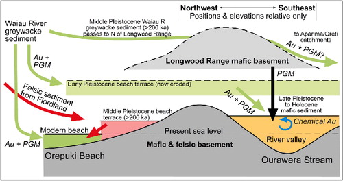
The postulated higher terrace in the headwaters of Ourawera Stream (now eroded; ) may have contained greywacke clasts, as well as detrital gold, from a paleo-Waiau River in a middle Pleistocene interglacial period, attesting to the periodicity of differing sediment supply to the south coast. The apparent lack of garnets recycled with detrital gold and possibly greywacke from this postulated elevated terrace into the Ourawera Stream sedimentary pile, supports our contention that the sediment in the higher terrace was not derived from Fiordland (). There is no evidence for detrital gold or detrital PGM in the Fiordland-derived beach sediments at Orepuki Beach (), and this absence provides some support for derivation of gold and PGM from somewhere in the present eastern side of the Waiau catchment, rather than Fiordland. However, angular and equant PGM grains have been found at Round Hill mine, in addition to far-travelled proto-toroidal flakes, and these angular grains are presumed to have been derived from the nearby Longwood Range (; Craw et al. Citation2013).
Authigenic gold mobilisation
Although the age of the gold-bearing Ourawera Stream sediments is not known with any accuracy, the paleogeographic inferences described above suggest that these sediments were deposited during glacial periods in the late Pleistocene. At least some of the authigenic gold overgrowths in the Ourawera Stream sediments () have formed since sedimentary deposition, as the delicate textures would not have survived erosion and fluvial transport in the high-gradient stream. Hence, at least some of the authigenic gold arose from groundwater-driven gold remobilisation processes (). Similar textures have been described from late Pleistocene fluvial sediments elsewhere in the southern South Island (Youngson & Craw Citation1993; Reith et al. Citation2012).
Gold overgrowth textures similar to those described from Ourawera Stream occur in Pliocene sediments in the Waimumu goldfield in the eastern detrital gold transport pathway (; Falconer et al. Citation2006; Falconer & Craw Citation2009). Like many of the Ourawera Stream sediments, the Waimumu authigenic gold occurrences are accompanied by authigenic iron sulfide : pyrite and/or marcasite (Falconer et al. Citation2006). Waters sampled from the Ourawera Stream catchment have generally overlapping compositions with groundwaters in the Miocene and younger sediments of the Southland region between Waimumu and the south coast, although there are some differences (, ). A distinctive feature of some Ourawera and Southland water compositions is their relatively high alkalinity compared with their calcium contents, implying dissolution of carbonate mineral(s) other than calcite (). The Ourawera Stream sediments, derived partly from mafic sources in the Longwood Range, may have contained ankeritic carbonates as part of their metamorphic or hydrothermal alteration assemblages (Ashley et al. Citation2012). The observed Na/Cl ratios suggest that some of the dissolved load has been derived from marine aerosols, and that is the probable source of at least some of the sulfate that contributed to authigenic pyrite deposition (Falconer et al. Citation2006). The moderately elevated sulfate content of one Ourawera sample, from a mine tailings pond, may reflect oxidation of authigenic pyrite in the tailings, similar to that which occurs in the Waimumu deposits (Falconer et al. Citation2006). The general overlap between the Ourawera and Southland water compositions suggests that authigenic gold deposition processes were also similar in both areas, although the exact chemical processes are as yet undefined (Falconer et al. Citation2006; Falconer & Craw Citation2009).
Placer gold particles from the heavy mineral concentrates on Orepuki Beach have many of the features of the gold in the Ourawera Stream sediments, including toroidal shapes, polymorphic encrustations and authigenic gold (–). Delicate authigenic gold overgrowth textures, such as those observed in Ourawera Stream (), are not found in the beach placers, presumably because of constant tidal reworking. However, the polymorphic encrustations and associated embedded authigenic gold may have been carried with the detrital toroids during recycling from older coastal sediments (). Alternatively, these features may have been imposed on the gold particles within an active beach environment, as the toroids formed. In this latter case, the geochemical environment would have been dominated by saline (seawater) solutions that were quite different from those prevailing in the Ourawera Stream sediments (). Etching and dissolution of gold from seawater attack of particle surfaces can form mobile gold(I/III)–oxohydroxychloride complexes (Usher et al. Citation2009; Reith et al. Citation2012), and these may have subsequently re-precipitated nearby to form the authigenic gold in the polymorphic encrustations (). If this has occurred for the Orepuki Beach gold, it may also have occurred on older beaches to provide some of the polymorphic encrustations and associated authigenic gold textures that then may have been recycled into Ourawera Stream sediments.
Dissolution and re-precipitation features were common on almost all of the gold grains studied from the Orepuki Beach sediments, but these features are absent from coexisting isoferroplatinum grains (–). This distinction between environmental gold and platinum mobility has been observed elsewhere, and linked to biologically mediated processes (Fairbrother et al. Citation2012; Brugger et al. Citation2013). Dissolved gold complexes have higher cell-toxicity than dissolved platinum complexes, which can lead to toxic levels of dissolved gold in the vicinity of particle surfaces (Brugger et al. Citation2013; Wiesemann et al. Citation2013). Elevated gold toxicity can lead, in turn, to biomineralisation of nano- and micro-particulate gold as well as bacteriomorphic gold (Reith et al. Citation2014). These processes could occur in the active beach environment, such as Orepuki Beach, or in fluvial sediments such as at Ourawera Stream, and we cannot yet distinguish these potential gold mobility settings.
Conclusions
Modern gold-bearing fluvial sediment in the lower Waiau River catchment, Southland, contains mainly greywacke-sourced detritus, and this sediment dominates on the auriferous beaches of Foveaux Strait at the Waiau River mouth. Sediment derived from these greywacke sources bypassed the lower Waiau catchment at times during the Pleistocene, and felsic debris derived from Fiordland crystalline rocks forms some raised beach deposits along the Foveaux Strait shoreline. By contrast, the small Ourawera Stream catchment, which hosts the largest placer goldfield in the area, including the Round Hill mine, is dominated by highly heterogeneous fluvial sediments derived from nearby mafic and felsic rocks of the Longwood Range basement. Magnetite and ilmenite are the predominant heavy minerals in all the sediments examined, but the proportions of these minerals vary widely, especially in the Ourawera Stream sediments. Heavy mineral concentrates formed on active beaches are dominated by ilmenite, and placer gold accumulates in these concentrates. By contrast, placer gold in the immature fluvial Ourawera Stream sediments has been concentrated in layers enriched in Fe-rich silicates as well as Fe-bearing oxides, and the highest gold concentrations do not coincide with the most magnetic sediments.
Detrital gold particles generally have a toroidal shape in all sediments examined along the Foveaux Strait, as a result of windborne sand abrasion and peening of particle edges on exposed beaches. Gold toroids have been uplifted with Pleistocene marine terraces, and subsequently eroded and recycled into younger sediments, including the fluvial sediments of the Ourawera Stream catchment. Embayments in gold toroid surfaces almost invariably contain encrustations of polymorphic material that includes clays and bio-organic matter. Many such encrustations also contain nano- and micro-particulate authigenic gold that has been mobilised from the host particles by biogeochemical processes. Toroids in the Ourawera Stream fluvial sediments also contain delicate overgrowths of nano- and micro- particulate authigenic gold that has formed in situ since the late Pleistocene deposition of the host sediments. Isoferroplatinum particles that occur with detrital gold on Foveaux Strait beaches have undergone less physical deformation than gold, with only minor wind-driven peening of particle margins. Likewise, there has been no biogeochemical mobilisation of platinum from these particles, in strong contrast to the accompanying gold particles.
Acknowledgements
This research was funded by the Marsden Fund, which is administered by the Royal Society of New Zealand, the Ministry of Business, Innovation and Employment, and the University of Otago. Reith’s contributions were funded by the Australian Research Council (LP100200102 to F Reith). Supply of drillhole samples and associated gold particles from an exploration programme by Glass Earth Gold is gratefully acknowledged, and Simon Henderson kindly facilitated our access to the material and provided useful input. Discussions with Barry Douglas, Rob McCann, Mark Mitchell, Ian Turnbull, and John Youngson were helpful in developing the ideas expressed herein. Doug MacKenzie provided valuable assistance with field instrumentation. Technical assistance was ably provided by Marco Brenna, Lisa Craw, Brent Pooley, and Damian Walls. Constructive reviews by anonymous referees helped to clarify the presentation.
References
- Ashley P, Craw D, MacKenzie D, Rombouts M, Reay A 2012. Mafic and ultramafic rocks, and platinum mineralisation potential, in the Longwood Range, Southland, New Zealand. New Zealand Journal of Geology and Geophysics 55: 3–19.
- Brugger J, Etschmann B, Grosse C, Plumridge C, Kaminski J, Paterson D et al. 2013. Can biological toxicity drive the contrasting behavior of platinum and gold in surface environments? Chemical Geology 343: 99–110.
- Burridge CP, Craw D, Waters JM 2007. An empirical test of freshwater vicariance via river capture. Molecular Ecology 16: 1883–1895.
- Craw D 2013. River drainage reorientation during placer gold accumulation, southern New Zealand. Mineralium Deposita 48: 841–860.
- Craw D, Burridge C, Anderson L, Waters JM 2007. Late Quaternary river drainage and fish evolution, Southland, New Zealand. Geomorphology 84: 98–110.
- Craw D, Mitchell M, McCann R, Reay A 2013. Compositional variations and morphological evolution in platinum beach placers, southern New Zealand. Mineralium Deposita 48: 81–97.
- Cullen DJ 1967. The submarine geology of Foveaux Strait. New Zealand Oceanographic Institute Memoir 33. Wellington, New Zealand Oceanographic Institute. 67 p.
- Douglas BJ 1986. Evaluation of an auriferous placer sand deposit, ML 32-1493, Round Hill goldfield, Southland. Unpublished mineral report MR3105. Wellington, New Zealand Petroleum and Minerals.
- Durie M 2001. Hydrogeology of the Eastern Southland Plains, New Zealand. Unpublished MSc thesis. Christchurch, University of Canterbury Library.
- Fairbrother L, Brugger J, Shapter J, Laird JS, Southam G, Reith F 2012. Supergene gold transformation: biogenic secondary and nano-particulate gold from arid Australia. Chemical Geology 320: 17–31.
- Falconer DM, Craw D 2009. Supergene gold mobility: a textural and geochemical study from gold placers in southern New Zealand. In: Supergene environments, processes and products. Economic Geology Special Publication 14: 77–93.
- Falconer DM, Craw D, Youngson JH, Faure K 2006. Gold and sulphide minerals in Tertiary quartz pebble conglomerate gold placers, Southland, New Zealand. Ore Geology Reviews 28: 525–545.
- Haffert L, Craw D 2009. Field quantification and characterization of extreme arsenic concentrations at a historic mine processing site, Waiuta, New Zealand. New Zealand Journal of Geology and Geophysics 52: 261–272.
- MacPherson EO 1937. The geology of the Waimumu alluvial goldfield and notes on quartz conglomerates in Southland. New Zealand Journal of Science and Technology 18: 772–778.
- MacPherson EO 1938. The Round Hill goldfield, Southland. New Zealand Journal of Science and Technology 19: 743–749.
- McCann R, Craw D 2009. Gold and platinum deformation in beach placer deposits, Southland. Australasian Institute of Mining & Metallurgy 42nd New Zealand Branch Annual Conference, Queenstown, New Zealand. Pp. 273–284.
- McCoy-West AJ, Mortimer N, Ireland TR 2014. U–Pb geochronology of Permian plutonic rocks, Longwood Range, New Zealand: implications for Median Batholith–Brook Street Terrane relations. New Zealand Journal of Geology and Geophysics 57: 65–85.
- Mortimer N, Gans P, Calvert A, Walker N 1999. Geology and thermochronometry of the east edge of the Median Batholith (Median Tectonic Zone): a new perspective on Permian to Cretaceous crustal growth of New Zealand. Island Arc 8: 404–425.
- Norris RJ, Carter RM, Turnbull IM 1978. Cainozoic sedimentation in basins adjacent to a major continental transform boundary in southern New Zealand. Journal of the Geological Society, London 135: 191–205.
- Reith F, Campbell SG, Ball AS, Pring A, Southam G 2014. Platinum in Earth surface environments. Earth-Science Reviews 131: 1–21.
- Reith F, Stewart L, Wakelin SA 2012. Supergene gold transformation: secondary and nanoparticulate gold from southern New Zealand. Chemical Geology 320: 32–45.
- Turnbull IM, Allibone AH 2003. Geology of the Murihiku area. Institute of Geological and Nuclear Sciences 1:250 000 geological map 20. Lower Hutt, Institute of Geological and Nuclear Sciences.
- Turnbull IM, Allibone AH, Jongens R 2010. Geology of the Fiordland area. Institute of Geological and Nuclear Sciences 1:250 000 geological map 17. Lower Hutt, Institute of Geological and Nuclear Sciences.
- Usher A, McPhail DC, Brugger J 2009. A spectrophotometric study of aqueous Au(III) halide-hydroxide complexes at 25–80 °C. Geochimica et Cosmochimica Acta 73: 3359–3380.
- Ward CM 1988. Marine terraces of the Waitutu district and their relation to the late Cenozoic tectonics of the southern Fiordland region. Journal of the Royal Society of New Zealand 18: 1–28.
- Wiesemann N, Mohr J, Grosse CM, Herzberg M, Hause G, Reith F et al. 2013. Influence of copper resistance determinants on gold transformation by Cupriavidus metallidurans strain CH34. Journal of Bacteriology 195: 2298–2308.
- Williams GJ 1974. Economic geology of New Zealand. Australasian Institute of Mining & Metallurgy Monograph 4. Melbourne, Australasian Institute of Mining & Metallurgy.
- Wood BL 1969. Geology of the Tuatapere Subdivision, western Southland. New Zealand Geological Survey Bulletin 69. Wellington, New Zealand Geological Survey.
- Youngson JH, Craw D 1993. Gold nugget growth during tectonically induced sedimentary recycling, Otago, New Zealand. Sedimentary Geology 84: 71–88.
- Youngson JH, Craw D, Falconer DM 2006. Evolution of Cretaceous–Cenozoic quartz pebble conglomerate gold placers during basin formation and inversion, southern New Zealand. Ore Geology Reviews 28: 451–474.