
ABSTRACT
The Kerepehi Fault is an active normal fault with a total onshore length of up to 80 km comprising six geometric/rupture segments, with four more offshore segments to the north. For the last 20 ± 2.5 ka the slip rate has been 0.08–0.4 mm a–1. Average fault rupture recurrence intervals are 5 ka or less on the central segments and 10 ka or more on low slip rate segments to the north and south. Characteristic earthquakes for a single segment rupture range from Mw 5.5 to 7.0, and up to Mw 7.2 or 7.4 in the unlikely event of rupture of all the onshore fault segments. Fault rupture would result in damage to unreinforced masonry buildings, chimneys and parapets in Auckland (45 km nearest distant). Very severe damage to buildings in towns within the Hauraki Plains without specific seismic design (those built before 1960) may pose a significant risk to life and livelihood.
Introduction
The Kerepehi Fault, in the Hauraki Plains region of northern North Island, New Zealand, is a NNW-trending active normal fault (). The Kerepehi Fault and its offshore extension in the Hauraki Gulf has received some attention in previous studies related to geological mapping (Houghton & Cuthbertson Citation1989), active faulting and earthquake hazard (de Lange & Lowe Citation1990; Stirling et al. Citation2012; Litchfield et al. Citation2014), and tsunami hazard (Chick et al. Citation2001). These studies characterised the fault as a series of right-stepping en echelon traces ranging in length from 10 to 43 km with step-overs ranging from 3 to 6 km. Recent access to LiDAR (light detection and ranging) data has revealed a far more complex pattern of Holocene fault traces displacing the alluvial terrace surfaces of the Hauraki Plains than earlier appreciated. Whereas earlier mapping suggested relatively simple fault strands, the LiDAR-based interpretation indicates a surface faulting pattern very similar in terms of density and complexity to that described from the Taupo Rift (e.g. Villamor & Berryman Citation2001; Berryman et al. Citation2008). Typically there are one or two main strands in each segment and a myriad of generally shorter secondary strands that splay from, or are parallel to, the main strands. The Kerepehi Fault is the most northerly active fault in New Zealand with clear evidence for activity in the Holocene; it therefore makes a contribution to seismic hazard in large northern North Island cities including Auckland, Hamilton and Tauranga.
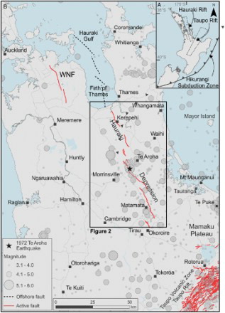
Figure 1. A, Location of the Hauraki Rift on the North Island of New Zealand with respect to the Taupo Rift (dashed grey rectangle) and the Hikurangi Subduction Zone. B, Location of main onshore active fault traces (red lines) and offshore active faults (dashed black lines) mapped prior to this study. All mapped traces are dipping to southwest. Onshore traces in the Hauraki Depression belong to the Kerepehi Fault. WNF is the Wairoa North Fault, the only other active fault known in the region (Wise et al. Citation2003). Offshore traces were mapped by Chick et al. (Citation2001). Also plotted is the location of earthquakes with Mw >3.0 for the historic period until May 2015. The largest recent event is the 1972 Mw 5.1 Te Aroha earthquake.
The aim of this study is to document the location of active traces of the Kerepehi Fault and to derive the magnitude of earthquakes associated with surface rupture and their recurrence. We assess the rupture history of each of the main on-land strands of the fault using tectonic geomorphology and paleoseismology studies. We have used a high-resolution digital elevation model (DEM) derived from LiDAR data to map the faults, and traditional paleoseismic trenching techniques combined with radiocarbon dating to assess the earthquake history and derived potential earthquake magnitudes (see Table S1 for more details of methods). From these data we obtain an indication of ground-shaking effects, and possible damage in major population centres of northern North Island, associated with large earthquakes on the Kerepehi Fault.
Geologic and tectonic setting
The Hauraki Rift
The Kerepehi Fault is located within the Hauraki Rift, a half-graben which extends from the Taupo Rift NNW towards the Hauraki Gulf () separating the Coromandel Peninsula and Great Barrier Island from the Auckland and Northland Peninsula. The Hauraki Rift is c. 20–40 km wide and c. 250 km long (Hochstein & Nixon Citation1979; Hochstein et al. Citation1986; de Lange & Lowe Citation1990; Hochstein & Ballance Citation1993), and comprises three distinct sections from north to south: the Hauraki Gulf, the Firth of Thames and the onshore Hauraki Depression ().
The Hauraki Rift has been active since late Neogene time (Hochstein & Nixon Citation1979; Davidge Citation1982) before rifting shifted to the Taupo Rift at c. 2–3 Ma (; Wilson & Rowland Citation2016). The Hauraki Rift is situated in the back-arc of the Hikurangi subduction margin, parallel to the now-extinct volcanic arc of the Coromandel (Hochstein & Ballance Citation1993). Our study area, the Hauraki Depression, contains two main NNW-striking normal faults: the now-inactive Hauraki Fault at the foot of the Kaimai Ranges at the eastern margin of the depression; and the Kerepehi Fault, an active central-depression normal fault (). The western boundary is formed by a minor hinge fault, the Firth of Thames Fault (Hochstein & Nixon Citation1979; de Lange & Lowe Citation1990) ().
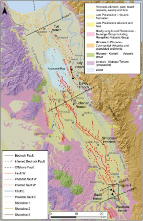
Figure 2. Active fault traces of the Hauraki Rift, mapped here using a high-resolution DEM derived from LiDAR on a background geology map of the Hauraki Rift (simplified from Edbrooke Citation2001). Note that faults dipping to the southwest and the northeast are in red and grey-blue, respectively. Base map is a low-resolution DEM from LINZ. Shorelines are also mapped with LiDAR-DEM (see full DEM in Figure S2). Shore line 3 corresponds to that mapped by Schofield (Citation1976). Solid black diamonds represent the location of trenches. Dark red numbers show the fault scarp heights (m). Black transverse lines are location of topographic profiles presented in . Offshore fault segment is from Chick et al. (Citation2001).
Numerous hot springs occur within the Hauraki Depression. Hochstein and Nixon (Citation1979) calculated, from geothermometry of the springs, that an anomalously high heat flow exists below the southern part of the rift. This suggests that there is an upper mantle swell below the Hauraki Depression (Davidge Citation1982), indicating thinned crust in this region.
Present-day seismic activity in the region is diffuse, but with a concentration in the central and southern Hauraki Depression (). Most earthquakes in the region have focal depths of ≤12 km. In a microearthquake survey, Backshall (Citation1982) recorded 21 earthquakes with ML 0.3–1.2 located between Te Aroha and Morrinsville at depths of ≤10 km and concluded that the nature of the macro- and microearthquake activity beneath the Hauraki Plains is typical of an active continental rift. The largest recent earthquake was the 1972 Te Aroha earthquake of Mw 5.2 (Adams et al. Citation1972) (). In July 2005 a swarm occurred within 5 km of Te Aroha (the largest event was Mw 3.7; http://info.geonet.org.nz/display/quake/2005/07/02/Jul+2+2005+-+Te+Aroha+Earthquake+Swarm) and two events occurred in November 2014 close to Waharoa (largest event was Mw 3.9; http://info.geonet.org.nz/display/quake/2014/11/07/Moderate+earthquakes+rattle+Waikato+region). Geodetic data in the region were insufficient to enable the Kerepehi Fault to be delineated in the North Island block model of Wallace et al. (Citation2004). Differences in velocities of widely spaced GPS stations in the region (Wallace et al. Citation2004, ) suggest that any strain across the Kerepehi Fault was below the detection level. A denser network of stations in the region of the Hauraki Rift may resolve possible contemporary strain rates.
Geological setting and geochronological markers within the Hauraki Depression
The Hauraki Depression is surrounded by volcanic and sedimentary bedrock units. Jurassic meta-greywackes and Tertiary volcanic rocks bound the depression to the southwest; to the east and northeast the depression is bounded by Tertiary and Quaternary volcanic rocks of the Coromandel Volcanic Arc (Healy et al. Citation1964; Schofield Citation1967; Hochstein & Nixon Citation1979; Houghton Citation1987; de Lange & Lowe Citation1990; ). The southern end of the Hauraki Depression has been in-filled with the 240 ka Mamaku ignimbrite that was erupted from the Rotorua caldera of the Taupo Volcanic Zone (TVZ) (Hochstein & Ballance Citation1993; Milner et al. Citation2003). The Hauraki Depression itself is inferred to be filled with c. 2.5–3 km thick Tertiary and Quaternary terrestrial sediments (Kear & Tolley Citation1957; Healy et al. Citation1964; Hochstein & Nixon Citation1979; Hochstein & Ballance Citation1993), the youngest of which are the alluvial volcaniclastic Hinuera Formation, deltaic and estuarine sediments and locally reworked sediments (Healy et al. Citation1964; Hume et al. Citation1975; Cuthbertson Citation1981; Houghton & Cuthbertson Citation1989; de Lange & Lowe Citation1990) ().
The Hinuera Formation is especially important for this study because it is an extensive marker horizon for the assessment of the faulting history of the Kerepehi Fault. The formation contains reworked pumice alluvium from the Mamaku Plateau, the TVZ and the Kaimai Range (Cuthbertson Citation1981) which was deposited through coalescing alluvial fans that graded northwards into a braided river outwash plain. Deposition of the earliest Hinuera sediments began directly after the emplacement of the Mamaku ignimbrite at 0. 24 Ma (Cuthbertson Citation1981; Gravley et al. Citation2007). The main sedimentation phase took place after the Oruanui eruption however (25.4 ka; Vandergoes et al. Citation2013), and continued until the deposition of the Rerewhakaaitu tephra at about 17. 6 ka (Manville & Wilson Citation2004). The ancestral Waikato River abandoned its route across the Hauraki Plains at about this time and re-established an earlier route across the Hamilton Basin to the Tasman Sea, as occurs to the present day. Within the Hauraki Plains, two aggradational surfaces and associated deposits are described as the Hinuera 1 and Hinuera 2 surfaces (Cuthbertson Citation1981). They have been redefined recently as Hinuera B and Hinuera C surfaces by Manville and Wilson (Citation2004). Hinuera B is dated at 26.5–22.5 ka, based on the distribution of Okareka tephra (c. 21.8 ka; Lowe et al. Citation2008), and Hinuera C at 22.5–17.6 ka ( (Manville & Wilson Citation2004). Other important tephra that assist in bracketing the timing of prior surface rupture events include the Tuhua tephra erupted from Mayor Island (7005 ± 155 cal yr BP; Lowe et al. Citation2008) and the Taupo tephra erupted from the Taupo caldera (c. 1718 ± 5 cal yr BP; Hogg et al. Citation2012).
The oldest Quaternary terrace surfaces in the Hauraki Plains are the Hinuera B surfaces which are found in the southern part of the Hauraki Depression. Towards the centre and the north, the younger and lower-Late-Pleistocene-aged Hinuera C surfaces or degraded Hinuera C terraces of Holocene age cover most of the Hauraki Depression. Adjacent to the Firth of Thames, the Hinuera C surface is covered by young estuarine sediments deposited under conditions of rising sea level during the early Holocene transgression. The shoreline related to the culmination of sea-level rise following the last glaciation at c. 7.5 ka (Clement et al. Citation2010) is a useful marker adjacent to the Firth of Thames with respect to the timing of the most recent surface rupture of the Kerephi Fault (). Discrete tephra layers are found mainly in old oxbows along Pleistocene–Holocene river terraces and in extensive swamps (e.g. the Kopouatai Bog, see de Lange & Lowe Citation1990). Elsewhere, the Holocene tephra sequence is usually observed as a composite unit.
The Kerepehi Fault
In previous studies, the Kerepehi Fault has been examined mainly by geophysical methods, both onshore and offshore (e.g. Hochstein & Nixon Citation1979; Tearney Citation1980; Davidge Citation1982; Rawson Citation1983; Hochstein et al. Citation1986; Hochstein & Ballance Citation1993; Chick Citation1999; Chick et al. Citation2001). In the south of the Hauraki Depression, the Kerepehi Fault bounds the west side of a buried mid-valley horst (Hochstein & Nixon Citation1979). Its location at the northern end of the Hauraki Depression towards the Firth of Thames and in the Hauraki Gulf is less well established. The fault strikes 340°, parallel to the boundaries of the depression (Hochstein et al. Citation1986). The total throw of the fault in the greywacke basement as determined by geophysical methods is 1.1–3.5 km (Hochstein & Nixon Citation1979; Tearney Citation1980; Hochstein & Ballance Citation1993). de Lange and Lowe (Citation1990) suggested that the fault crosses Kopouatai Bog north of Elstow based on the displacement of several tephra layers, but we provide new data that questions this interpretation (see ‘Recurrence interval of faulting on the Elstow segment’).
Active traces of the on-land Kerepehi Fault
Our study shows that the on-land portion of the Kerepehi Fault is an active, predominantly west-dipping, normal fault expressed at the ground surface by traces over a length of at least 71 km (mapped traces) and could be up to 80 km (inferred traces; ). From the trace geometry we divide the on-land portion of the fault into six geometric segments. We name these, from south to north, Okoroire (>5 km long), Te Poi (27 km long), Waitoa (43 km long), Elstow (12 km long), Te Puninga (22 km long) and Awaiti (>27 km long) segments. In the Firth of Thames, Chick et al. (Citation2001) identified four segments from high-resolution seismic reflection profiling that range in length from 9 to 19 km (), although the southernmost offshore segment is less confidently identified because of very shallow water and gas masking in the sea-bottom sediments (W de Lange, pers. comm. 2015). In addition, we have identified a probable linking structure between the Te Poi and Waitoa segments that is 10 km long (). There are also traces up to 3 km west of the Te Poi segment, 4 km east of the Waitoa segment and 6 km alongstrike of the northern end of the Waitoa segment that do not group very well into our description of segments.
Each segment comprises numerous fault traces. The fault traces are sinuous but relatively continuous for distances of 20 km or so; overall, the fault is characterised as a series of overlapping right-stepping sections. The step-overs in between traces and segments are separated by distances of up to 4.2 km. The principal strands have scarps up to 8 m high across Hinuera C surfaces (, 3). Several discrete short scarps occur away from the main traces, especially close to the step-overs. The variability in surface expression of the fault may represent irregularities in the fault plane at depth, or in the fault propagation through the unconsolidated valley fill to the surface. Fault scarps are commonly irregular and include significant bends and embayments, typical of normal faults (e.g. Schwartz & Coppersmith Citation1984). Although the geomorphic scarps are similar in nature to river terrace risers, they cross terrace risers and this criterion is evidence of the tectonic origin of the traces. Evidence of tectonic tilt is also observed in topographic cross-sections derived from LiDAR data (, Figures S1, S2). There are rare exposures of a fault plane associated with the trace, and further evidence of deformation has been revealed in trench excavations. The common occurrence of stepped scarps probably represents movement on multiple fault strands.
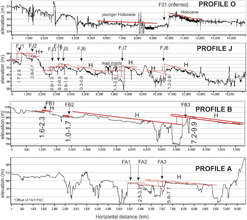
Figure 3. Topographic transects across the Hauraki Rift showing location of active faults and measurement of fault throw. The throw range represents the maximum and minimum values taking into account maximum and minimum surface tilt and uncertainties due to erosion of terrace surfaces. Note the eastwards tilting of the Hinuera surfaces (H is Hinuera C of Manville and Wilson, Citation2004) on the footwall of the main strands of fault segments.
All traces comprise simple or stepped scarps that are mostly west-facing (W traces of ). In some areas the scarps are steep and distinct, while in others they are broad and sometimes rather subtle warps (Figure S3). Most traces offset the relatively flat upper surface of the late Pleistocene Hinuera Formation mapped by Cuthbertson (Citation1981; ). Scarps across the Hinuera surface range from 1 to 8 m (, 3) in height. We characterise the fault as predominantly, if not exclusively, normal faults with a probable fault dip at a depth of 60 ± 15° (typical of normal faults in the Taupo Rift; Villamor & Berryman Citation2001). Some scarps cross Holocene degradational stream terraces (e.g. southeast of Matamata, ). Scarp heights decrease on successively younger, lower terraces, but no scarp cuts the youngest terraces adjacent to the modern river channels. A feature of the deformational style is tilting (generally to the east) of the Hinuera C surface on the footwall of the fault blocks as seen in cross-sections constructed from the LiDAR-derived DEM (, S2). The extension of the Awaiti segment northwards toward Kerepehi () is based upon this noticeable tilt of the Holocene-aged surface illustrated in and the DEM of Figure S2.
Fault rupture history of Kerepehi Fault
To investigate the rupture behaviour of the fault we have excavated trenches across the main strands of each of the geometric segments of the fault, with the exception of the Te Puninga segment on the central western side of the Hauraki Depression (identified in this study for the first time) and the Okoroire segment (). We selected sites for trenching where the scarp was simple and sharp, hoping that stratigraphic relationships would serve as a basis for determining both the timing and size of past surface rupture events. The Westlake and Madill trenches are on the Te Poi segment, the Simonsen trenches are on the Waitoa segment, the Buchanan trench is on the Elstow segment and the Davey trench on the Awaiti segment (). An additional trench adjacent to the Davey trench did not provide evidence for faulting on an adjacent, parallel lineament which is probably a terrace riser (). We additionally trenched a scarp in the northern part of the depression near the Piako River which we thought could have been the northern continuation of the Awaiti segment (the Tye trench), but this trench did not expose a fault. Detailed logs of the trenches and stratigraphic unit descriptions can be found in Datasets S1–S2 (Figures S4–S9; Tables S2–S9), and are presented in summary form in .
Okoroire segment
Fault scarps were mapped in the area between Okoroire and Hinuera (, 2) in 1986 (Foster & Berryman Citation1991). Scarps measure 2–3 m in height, both east- and west-facing, across surfaces of Hinuera age, and up to 10 m high facing west across older Pleistocene surfaces. The fault trace is mapped for at least 5 km. No excavations have been undertaken on this segment and it is outside the area covered by our recently obtained LiDAR coverage. It is possible that this fault segment continues to the SSE towards State Highway 5 about 6 km eastward from Tirau, which would extend the segment length to at least 10 km. The traces are located 3–4 km west of the southern end of the Te Poi segment ().
Te Poi segment
The Te Poi segment is 27 km long and extends from Te Poi, 8 km southeast of Matamata, to Hungahunga, 14 km north of Matamata (). It consists of several fault traces with vertical surface displacements that range from 1 to 8 m (). The scarp reaches its maximum height (8 m) around Matamata and from there decreases in height towards the northern and southern ends of the segment. In the south, some of the smallest displacements on this fault segment occur on young river terraces near the Waihou River and Mangawhero Stream (, 4). Here, displacements progressively decrease in height on lower surfaces, indicating that there has been repeated movement on this segment of the fault. The lowest and therefore youngest terraces are not displaced by the fault, and the highest terrace level that is displaced by the fault is a slightly degraded Hinuera C surface with 8 m of vertical offset ().
Figure 4. A, Topographic map compiled from detailed RTK-GPS study and LiDAR around the Westlake and Madill trenches on the Te Poi segment of the Kerepehi Fault, demonstrating the progressive displacement of terraces cut by the Mangawhero Stream and the Waihou River. The colour coding of the DEM is given in metres above mean sea level (asl). Black numbers are fault scarp heights (m). Coordinates are New Zealand transverse Mercator projection. B, Plot of terrace height (asl) versus fault throw (scarp height; blue points) on the hanging wall of the Kerepehi Fault. Younger (lower) terraces show less displacement (scarp height) because they have been ruptured by fewer paleoearthquakes, whereas older terraces show larger cumulative scarp heights. The displacement on successively higher and older terraces increases by about 1.5 m which we assume to be the single-event displacement of paleoearthquakes on this segment of the fault. Plot also shows a terrace age (from literature and field data, see text) v. terrace height curve (red line). The curve shows there was very rapid down-cutting after the formation of the aggradation surface at about 20 ± 2.5 ka , but down-cutting slowed down dramatically after c. 16 ka . Note that the two x-axes of the plot do not correlate with each other. C, Topographic profiles along the fault on the footwall and hanging wall with measured throw (scarp heights; red numbers in metres) along the fault. Note the increase of fault throw for similar height terraces towards the NW.
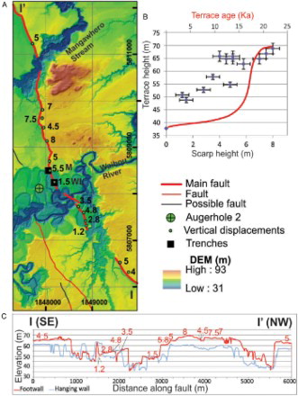
Except for the 1.2 m high scarp just to the south of the Waihou River (), 1.5–1.8 m high scarps are the smallest found along this segment and may represent a single-event displacement (SED). To confirm this we plotted the scarp height versus river terrace levels from a detailed topographic map constructed with a differential GPS system and LiDAR around the Waihou River and Mangawhero Stream area (). The survey extended for about 3 km along the fault, covering approximately 500–1000 m on each side of the fault scarp. Terrace-level elevations are plotted against the scarp heights in and it suggests that the displacement increases in steps of about 1.5 m with each higher terrace level, indicating that the single-event displacement is indeed about 1.5 m.
Based on this progressive displacement, we estimate the number of events recorded on the Hinuera C surface as probably four to five for a scarp height of 8 m (). Manville and Wilson (Citation2004) estimated the culmination of the accumulation phase of Hinuera C aggradation was 22.5–17.6 ka, so we estimate that the maximum displacements of 8 m occurred at c. 20 ± 2.5 ka ().
Trenches on the Te Poi segment
Two trenches, Westlake and Madill, have been excavated on the southern section of the main strand of the Te Poi segment.
Westlake trench
Westlake trench southeast of Matamata (, 4, Figure S4) was selected because the trace consists of a simple scarp on a low-elevation degradational terrace at c. 49 m elevation and is probably representative of only a single surface displacement. The excavation revealed a sequence of Hinuera deposits overlain by a 0.5 m thick Holocene-aged accretionary (up-building) soil sequence containing multiple ash and lapilli interbeds of mostly rhyolitic composition derived from the volcanic centres of the central North Island (, S4; Table S2).
Figure 5. Trench logs: A, Westlake trench (see full log in Figure S4). B, Madill trench (see full log in Figure S5). C, Simonsen trench 1 (see full log and log of Simonsen trench 2 in Figure S6). D, Buchanan trench (see full log in Figure S8). E, Davey trench (see full log in Figure S9). Note that radiocarbon samples in red on Davey trench were collected on the north wall and displayed at the correlating level on the south wall. Full unit descriptions are in Tables S2 and S4–S9. Note that the generalised legend uses similar colour tones for units that are approximately the same age but not necessarily the same environment. Unit numbers do not correlate across trenches.
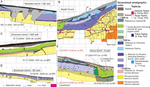
Deformation in this trench is manifest as small fissures (infilled with unit 2) nested within larger metre-scale wedge-shaped fissures infilled with unit 3, similar to the deformation mapped along the 1987 rupture of the Edgecumbe Fault (Beanland et al. Citation1989). The large fissures are associated with displacement of unit 5 and older. Deformed horizons are overlain by unit 1 (). A radiocarbon sample with an age of 540–320 cal yr BP from unit 2 (WE 1/1; S1) provides a useful maximum estimate for the younger episode of fissuring that we interpret as secondary displacement related to rupture of an adjacent segment of the fault based on the size of fissure 2 (see more discussion of interpreting rupture events from fissuring below). The older displacement has c. 1.5 m of vertical displacement on the base of unit 5, and fissuring in this event truncates the Holocene tephra unit.
Table 1. Radiocarbon ages.
Based on the preliminary information of ages of degradational terraces below the Hinuera C surface near the Waihou River, we estimate the age of the terrace at the Westlake trench to be about 16 ka based on the stratigraphy in auger hole 2, located in a cut-off meander of the Waihou River at the same elevation (; Table S3). From a peat overlying degradational Waihou River gravels (Table S3), Raupo (Typha orientalis) leaves gave an age of 16,947–16,381 cal yr BP (sample 77511/3; S1). A primary fault rupture on the Te Poi segment therefore occurred about the same time as the formation of the cut-off meander, that is, at c. 16 ka ().
Madill trench
The Madill trench is situated 200 m northwest of the Westlake trench (, 4, S5). At this location the scarp is c. 5.5 m high. The stratigraphy exposed in the trench (Table S4) comprises Hinuera deposits at the base and a succession of younger river gravel, overbank sand units, tephra, paleosols and a younger fluvial channel sequence of gravel, channel fill and young tephra that contains lapilli from the 1718 cal yr BP Taupo eruption (; ).
Based on the 5.5 m scarp height (see ), the results of the Westlake trench 200 m away along the same scarp and indications of single-event vertical displacement observed at the Westlake trench, we expected to find evidence for perhaps three earthquake ruptures in this trench.
The age of the terrace at the Madill site, at 62 m above sea level, is estimated to be 19 ± 1 ka. The altitude of the terrace at Madill site is lower than the Hinuera C surface (69 m) but higher than the terrace with auger hole 2 mentioned above (49 m) (). The terrace at the Madill site must therefore be older than the terrace with the auger hole 2 (i.e. c. 16 ka), but less than the 20 ± 2.5 ka age assigned to the Hinuera C surface by Manville and Wilson (Citation2004).
We have plotted the ages of terrace surfaces near the Waihou River against their height above sea level in . This plot suggests there was very rapid down-cutting after the formation of the aggradation surface (Hinuera C) at about 20 ± 2.5 ka. By about 19 ± 1 ka (Madill trench surface), the river had down-cut by about 7 m from c. 69 m to 62 m, and was at 49 m (12 m of down-cut) by c. 16 ka (auger hole 2 terrace). Between 16 ka and the present with the river at c. 36 m there are no further controls on the down-cutting (). The general form of the down-cutting is very similar to that described by Berryman et al. (Citation2010) from the Waipaoa River in the Gisborne district. With many more terraces dated there, the conclusion drawn was that when sediment supply declined the river switched to rapid down-cutting because it was no longer choked with sediment and had the power to erode to achieve a new grade. The down-cutting pulse was progressive up the Waipaoa catchment with earlier down-cutting downstream and later down-cutting upstream. In the Hauraki Plains a similar down-cutting process to that observed in the Waipaoa catchment is likely, implying that the period of degradational terrace formation may have been largely completed by 12–10 ka.
Within the Madill trench most of the faulting is within the Hinuera units (units 16 and 17), with the largest displacements found in the lowermost exposed Hinuera gravels (, S5). The main fault of the trench displaces the Hinuera gravels (unit 17) at the bottom of the trench vertically by about 1 m (). Faults in the lowermost gravel splay upwards into several faults with much smaller displacements in the Hinuera sands (unit 16). The majority of faults terminate within the Hinuera sands, and do not penetrate upwards into the overlying Waihou River gravels (unit 15). Only eight to nine of the faults seen in the Hinuera sands also displace the base of the Waihou River gravels.
Folding as well as faulting is a prominent feature of the deformation. Further up in the sequence in the Hinuera sands (unit 16), the main fault plane becomes shallower and rolls over towards the west, similar to most of the faults in the upper Hinuera sands. Due to the bending of the top of the faults, they show an apparent reverse displacement (). The faulting extending through the Waihou River gravel (unit 15) extends into unit 9.
The occurrence of at least two separate rupture events is confirmed by cross-cutting relationships on small-scale faults in the Hinuera sands and folding. The small-scale faults appear to have formed as vertical faults but rotated at their upper ends. After rotation, a new set of vertical faults was formed that cross-cut the older rotated set. The timing and size of each of these events is not possible to determine from the trench. However, if we divide the total displacement at the Madill trench of 5.5 m by the average SED of 1.5 m from progressive displacement of the Waiohou River terraces, at least three surface rupture events of 1.5–1.8 m probably occurred since 20–18 ka ().
Table 2. Earthquake events, single-event displacements (vertical), recurrence intervals and slip rates (vertical). All SEDs and slip rates are vertical values. The dip of Kerepehi Fault is unknown. If we assume similar fault dips as those described for the Taupo Rift (Villamor & Berryman 2001), a dip value of 60 ± 15 can be used.
Recurrence interval of rupture on the Te Poi segment
If we accept that interpretations from the Westlake and Madill trenches apply to the whole Te Poi segment then we have at least a secondary faulting event and three primary events. The secondary event is close in age to 540–320 cal yr BP (recorded in Westlake trench), and the most recent primary faulting event, with 1.5 m vertical displacement, occurred at c. 16 ka (recorded at Westlake trench and one of the three events interpreted from the Madill trench). The two older primary faulting events, averaging 1.5–1.8 m vertical displacement, occurred during the interval between 20–18 ka (Madill trench) and 16 ka. Scarps that are 7–8 m high on the Hinuera C surface (, 4) suggest one or two additional earlier events were probable at c. 19 ± 1 ka and 20 ± 2.5 ka to account for the additional 1.5–2.5 m difference in scarp height between the Madill trench site and fault scarp heights across the Hinuera C surface (). From these observations a very clustered history of fault rupture on this segment can be deduced, with four to five events in the period 22.5–16 ka (at maximum), and nothing more in the last 16 ka other than a very young secondary rupture at c. 0.5–0.3 ka (). The average recurrence intervals of 6.0–6.6 ka shown in are averaged over the whole timeframe and are therefore misleading. It is possible that not all surface ruptures will necessarily involve the main strand of the segment, and so the interpretation of the rupture history at a single site along the main strand may be modified when data from more sites on this segment are investigated.
Waitoa segment
The Waitoa segment may be up to 43 km long and stretches from Wardville/Hungahunga to about 8 km NNW of Otway within the Kopouatai Bog (). It is separated from the Te Poi segment by a right step of about 3 km, although a 10 km minor trace connects the two segments at the southern end suggesting the Waitoa and southern Te Poi segment may rupture together, at least on some occasions. The segment consists of a relatively continuous main strand but splays near its southern end with a divergent trace extending through Okauia. Fault scarps range in height from 1–2 m in the south, 3–5 m in the centre (near Waitoa) to about 8 m locally near Springdale before the splays in the north (). These larger scarp heights are generally all on the Hinuera C surface, so offsets of 2 m on the southern section of the segment are probably equivalent to the 5 m scarps near Waitoa. Scarps along this segment are mostly single trace distinct scarps, with the exception of one location in the centre of the segment that shows a double scarp with 3 m of surface displacement on each scarp.
Trenches on the Waitoa segment
Two trenches (Simonsen 1 and 2; , S6, S7) have been excavated at the southern end of this fault segment to the east of Hungahunga ().
Simonsen trenches
The Simonsen site was selected for trenching because the floor of a small stream channel is displaced by only 0.8 m and the adjacent terrace surface is displaced by 1.5 m, suggesting information on the size and the timing of the last two faulting events on this strand of the Kerepehi Fault could be obtained.
Simonsen 1 trench was excavated across the 0.8 m high scarp and exposed Hinuera pumice alluvium (unit 5) overlain by a younger Holocene channel-fill deposit (unit 3), Taupo ash (unit 2) and topsoil (unit 1) (, S6; Table S5). A distinct fault was seen displacing the Hinuera alluvium (unit 5) and the base of the channel-fill deposits (unit 3) near the middle of the trench. The channel-fill deposit (unit 3) is thicker on the downthrown side of the fault, suggesting it filled across a pre-existing scarp. The channel fill unit itself is displaced, so at least two events have occurred in the period since deposition of the Hinuera deposits ( one pre- and one post-channel fill; unit 3). The deformation of the channel-fill unit suggests at least c. 0.35 m and up to 1.5 m of displacement (if the base of the channel was horizontal before the deformation). The timing of the most recent event (MRE) can be estimated from radiocarbon ages of samples obtained from unit 3. The faulting is certainly younger than the basal age of 7655–7437 cal yr BP (S1/1 in ; ) and may be a little younger or similar to the upper sample age of 5736–5068 cal yr BP (S1/3 in ; ), depending on whether the horizon from which the upper sample was collected goes across the top of the fault tip or was displaced. The most probable timing of this faulting event is a little earlier than the upper sample (i.e. c. 5.3 ± 0.5 ka).
Simonsen 2 trench exposed no actual fault planes but showed that deformation had been accommodated by warping and ground cracking (Figure S6). A peat unit within the Hinuera deposits (unit 5; Table S6) is warped down by about 1.5 m, the same as the ground surface (Figure S6). The larger scarp height at Simonsen 2 site suggests that there is an additional event older than that at Simonsen 1 trench. Cracks are filled with an old soil that has an age of 719–500 cal yr BP (SI 2/1; ) and is different in character from the present topsoil that occurs on the upthrown side of the fault (, S6), suggesting a secondary faulting event at this time ().
Recurrence interval of rupture on the Waitoa segment
Observations from the two trenches show that at least two primary faulting events have occurred at this site since the formation of the Hinuera surface: one in the period after terrace formation on the Hinuera deposits at c. 20 ka (Simonsen 2 trench) and older than the base of unit 3 at 7655–7437 cal yr BP (oldest age from Simonsen 1 trench); and the second event at c. 5.3 ± 0.5 ka (Simonsen 1 trench; ). In addition, a secondary faulting event occurred close to 719–500 cal yr BP. These data suggest two or perhaps three (if the latter were primary rather than secondary) primary rupture events in the past c. 20 ka. For the two events that are clearly primary, an average recurrence interval of 6.2–7.3 ka can be estimated if the MRE is closer in age to 5.3 ka (i.e. two events in 14.7 years during 20–5.3 ka ) or to 7.5 ka (two events per 12.5 ka), respectively ().
About 200 m west of the Simonsen trench sites the scarp is about 4 m in height compared with the 1.5 m observed at the trench sites, even though the terrace apparently remains the same; at one locality along this segment of the fault shows a double scarp with 3 m of surface displacement on each scarp. Further north along this segment scarp heights reach 8 m near Springdale on a surface estimated to be 20 ± 2.5 ka in age (). The smallest scarps measured in the same vicinity are about 3 m (field measurements from Foster & Berryman, Citation1991), suggesting two to three ruptures in the past 20 ± 2.5 ka in this area. Together these data suggest an average recurrence interval of primary rupture on the Waitoa segment of 6.2–7.3 ka ().
Elstow segment
Scarps of the Elstow segment extend for 12 km from near Waihou northwards into the eastern part of the Kopouatai Bog (). This short segment could also be a northern splay of the Waitoa segment. However, we choose to interpret it as a separate segment because trench data indicate a different rupture event and there is a 3–4 km step between the main strands. Scarps of the Elstow segment south of Kopouatai Bog comprise broad single and double traces which are 1.5–4 m high on the Hinuera C surface.
De Lange and Lowe (Citation1990) trace the Elstow segment through the Kopouatai Bog, inferred from apparent displacements of tephra layers from drillhole data (Figure S7). However, our aerial photo, LiDAR- derived DEM and paleoseismic trenching shows that the Elstow segment of the Kerepehi Fault extends into the bog by only 2.5 km and then steps to the right by 3 km, paralleling the Kopouatai Bog just outside its eastern margin (Awaiti segment, , 3, S7). Several c. 2 km long traces have been mapped in the bog as potentially active based on DEM analysis, but these do not coincide with the fault location mapped by de Lange and Lowe (Citation1990).
Trenches on the Elstow segment
Buchanan trench
The only trench on the Elstow segment, the Buchanan trench site, was chosen at the location of a relatively narrow distinct scarp along this relatively short strand of the Kerepehi Fault (about 1 km south of Mellon Road near Elstow Hall, ). At this site, the trace consists of a 1.75 m high scarp, but a few metres northwest and southeast of the trench site the trace has two stepped scarps each with c. 0.75–2 m vertical offset.
The trench exposes Hinuera pumice alluvium (units 5 and 6) overlain by a clay unit (unit 4), a paleosol (units 2 and 3) on the clay and the modern topsoil (unit 1) (, S6; Table S7). The Hinuera pumice alluvium contains liquefaction features that reach up into the clay unit. In addition, some larger cracks in the Hinuera pumice alluvium are filled by material of the clay unit. The paleosol units 2 and 3 are truncated by the topsoil in the upper part of the scarp.
The deformation in the trench manifests itself by warping and ground cracking similar to the deformation caused by the Edgecumbe earthquake in 1987 (Beanland et al. Citation1989). All units are down-warped by 1–1.6 m. The cracks are filled by yellow-brown soil material different from the organic-rich topsoil. The soil in the cracks was radiocarbon dated to 6740–6495 cal yr BP (C4 in , ). We therefore assign a 6.6 ± 0.2 ka age to the earthquake that caused ground fissuring and warping.
Recurrence interval of faulting on the Elstow segment
From paleoseismic evidence, we show that rupture on the Elstow segment last occurred at 6.6 ± 0.2 ka. The total displacement in the Buchanan trench is 1.6 m (by warping), but we cannot conclusively say whether this displacement is entirely due to just one earthquake or to several events. From the difference in scarp heights (up to 4.5 m) along the Elstow segment we assume two to three events in the past 20 ± 2.5 ka if the 1.6 m found in the Buchanan trench is indicative of a single-event displacement (). The recurrence interval is therefore likely to be in the range of 5.8–11.2 ka ().
On the Elstow segment of the fault, de Lange and Lowe (Citation1990) have inferred small (0.2–0.7 m) rupture events at c. 1400, c. 5600, c. 6800 and c. 9000 years ago based on tephra horizons at different elevations in the Kopouatai Bog about 20 km northwest of Te Aroha. The Kopouatai Bog has had a complex history, evolving from a forest swamp at c. 12 ka to the current raised bog. There was also a large environmental change during the marine transgression up to c. 6 ka with spatial and temporal changes in peat accumulation (Newnham et al. Citation1995).
The displacements inferred by de Lange and Lowe (Citation1990) are much smaller and the average recurrence interval rather shorter than those we have identified by fault mapping and trenching on several segments of the fault. We identify a likely event at 6.6 ± 0.2 ka at the Buchanan trench which coincides with an event inferred by de Lange and Lowe (Citation1990), but we see no evidence of younger events. At the Davey trench (see also ‘Awaiti segment’ below) which lies just east of Kopouatai Bog we show that displacements are not achieved from many small displacements but rather several larger (1.0–1.5 m) displacements per event.
It is possible that fault traces have been obscured by peat growth and are not visible in the LiDAR DEM. However, without locating the fault planes inferred by de Lange and Lowe (Citation1990) with respect to the drillholes and understanding the depositional geometry of the peat layers (dependent on the type of mire, i.e. raised bog v. forest swamp), it is difficult to interpret the elevation differences of tephra horizons in the Kopouatai Bog peats as displacement along the Kerepehi Fault. The drillholes referred to by de Lange and Lowe (Citation1990) are widely spaced (e.g. southern most pair is at least 1 km apart) and the differences in elevation of the tephra are small. We therefore suggest that differences in the ground surface level at the time of tephra deposition, or post-deposition sediment compaction in the actively developing peat, are the most likely origin of the elevation differences in the tephra horizons. However, additional fault strands through the Kopouatai Bog cannot be definitively discounted until further detailed investigations to establish the presence of faulting and displacement of the tephra horizons across the fault planes have been undertaken.
Te puninga segment
Recent acquisition of LiDAR coverage of the Hauraki Plains has revealed a zone of active faults along the western margin of the plains in the vicinity of the re-entrant in the range front along the Firth of Thames Fault (, 2). This raises the possibility of reclassification of the western boundary fault of the Hauraki Depression as an active fault. The traces are distributed over a length of 22 km and a width of 5 km. A feature of this segment is the occurrence of some east-facing scarps along the western side of the zone, although there is a predominance of west-facing scarps overall. No trenches have been excavated on this segment. Interpretation of the LiDAR data suggests scarps 2.0–3.7 m high across probable Hinuera C surfaces (22.5–17.6 ka). The preliminary data suggest a surface slip rate of 0.08–0.21 mm a–1 ().
Awaiti segment
The Awaiti segment is the northernmost onshore segment of the Kerepehi Fault, separated from the Elstow segment by a 3–4 km right-step (). The Awaiti segment extends from Tirohia (2 km east of Kopouatai Bog) at least 27 km to 3 km northeast of Ngatea (). The extension of the fault north from Kerepehi is based entirely on the eastwards tilt of the terrace surface () as have observed further south in association with main strand fault scarps (). The surface scarp is removed by fluvial erosion from about 2 km north of Awaiti, although we infer the fault location is not very far west of the fluvial terrace riser (). Traces along this segment between Tirohia and Awaiti are 1–3 m in height.
Trenches on the Awaiti segment
Three trenches – Davey, Lucy and Tye () – have been excavated on this segment. We show the trench log for the Davey trench in and S9 (unit descriptions in Table S8), but the Lucy (2 km north of Davey trench) and Tye (about 2 km northwest of Kerepehi) trenches were, with hindsight, excavated across the terrace riser discussed above () and contained no faults. The Lucy and Tye trench logs are therefore not shown. We used some information from the Tye trench (Table S9) to assess ages of relevant geomorphic surfaces.
Davey trench
At the Davey trench site, the scarp is a double scarp parallel to the edge of Kopouatai Bog on Awaiti Road, about 1.5 km west of Tirohia (). The Davey trench was excavated across the lower scarp with 1.2 m of vertical offset. Two parallel normal fault planes were exposed at the lower end of the trench (). These faults offset all but the uppermost two soil layers. On the upthrown side of these faults, Hinuera pumice alluvium (unit 9; Table S8) is warped down by 0.9 m. This is overlain by a paleosol (unit 8) that shows ground fissuring which occurred when this paleosol was the ground surface. The fissures are filled with material morphologically and texturally different from the overlying peat unit. The Hinuera paleosol (unit 8) also shows some fractures that reach up into the overlying peat unit (unit 7) and its paleosol (unit 6), probably as a result of the younger event.
On top of the peat sequence on the upthrown side of the fault (units 6 and 7) there are a soil unit (unit 4) rich in organic material and a tephra (TuT) consisting of coarse rounded lapilli. This tephra was identified as the 7005 ± 155 cal yr BP Tuhua Tephra from Mayor Island based on its aegirine > clinopyroxene ferromagnesian mineralogy and two bracketing radiocarbon ages obtained from immediately above and below this unit in the southern wall of the trench (; ).
On the downthrown side of the faults, the lowest exposed unit is a peat unit (unit 5) which is almost entirely composed of twigs and pieces of wood. Above this unit lies the tephra interbed identified as Tuhua tephra (TuT), which is in turn overlain by an organic-rich clay unit (unit 3) which is missing from the upthrown side of the fault.
Unit 2 extends across the whole trench and contains two other closely spaced tephras that extend as discontinuous lenses within the unit. From the chronostratigraphic position and the tephra sequence within the bog, the upper discontinuous tephra is correlated with Kaharoa Tephra (636 ± 12 cal yr BP; Lowe et al. Citation2008) () from Okataina Volcanic Centre, while the lower is correlated with Taupo Tephra (1718 ± 5 cal yr BP; ) from Taupo Volcanic Centre on the basis of its similarity in grain size and appearance to known Taupo Tephra occurrences in the area. A single radiocarbon age of 2944–2761 cal yr BP (C7 in ) was obtained from a mixed soil horizon that includes Kaharoa and Taupo tephra lenses.
In the Davey trench we find evidence for two rupture events. Evidence of the first (oldest) earthquake event in this trench consists of ground fissuring on the paleosol of the Hinuera pumice alluvium (unit 8), undated here but younger than c. 22.5 ka . The cracks are filled with soil material with an age of 19,251–18,898 cal yr BP, and the overlying peat unit has a radiocarbon age of 14,047–13,767 cal yr BP (). The fissuring is likely to have occurred shortly after the underlying soil horizon was formed c. 19,252 yr BP. The earthquake event is therefore bracketed between 19,252 and 13,767 yr BP. A second (most recent) event formed two parallel faults which terminate just below the middle tephra layer which is identified based on its morphological expression and thickness as the Taupo ash (c. 1.7 ka). Minor faulting on the south wall displacing up to the base of unit 2 is also associated with this event. A radiocarbon age of faulted soil material below this horizon (at the top of unit 3) is 5982–5741 cal yr BP (C10 in ; ). The most recent rupture event is therefore constrained to between 5982 and 1718 yr BP ().
Tye trench
The Tye trench is located about 2 km north of Kerepehi () on what we now, with the benefit of LiDAR data after trenching was undertaken, recognise as a terrace riser. The trench did not expose faults or warping, but in situ shallow estuarine bivalve shells that were found at 2.4 m below the ground surface were dated at 6783–6582 cal yr BP (Tye 1 in ) and a piece of wood at 1.9 m depth was dated at 6490–6312 cal yr BP (Tye 6 in ; Table S8). These sediments and the coastal plain in this area are related to the highest Holocene sea-level transgression that culminated at c. 7.5 ka in this region (Clement et al. Citation2010). The shoreline retreated to its present position due to alluvial sedimentation, seen as an overbank of the Piako River above the shelly deposits. The age of the land surface is unclear but must be considerably younger than 7.5 ka because three paleosols have developed within the overbank alluvial stratigraphy above the dated shelly layer (Table S8).
Recurrence interval of faulting on the Awaiti segment
Rupture of the Awaiti segment is best constrained of all of the segments of the Kerepehi Fault because of clear evidence exposed in the Davey trench. These events occurred during the intervals 5982–1718 yr BP (most recent event) and 19,251–14,047 yr BP (penultimate event) with displacements of about 1 m during each event (). The recurrence interval indicated by these events is in the range of 8.1–17.5 ka ().
The recurrence interval can also be interpreted from single-event displacement and scarp heights along this fault strand. Scarp heights range between 1.5 and 2 m (). From the trench, we can assume the single- event displacement to be about 1 m. We can therefore confirm that there were only two events during the last 20 ± 2.5 ka and that the recurrence interval is c. 10 ka, which lies within the range estimated from the paleoseismic data ().
Earthquake history of the Kerepehi Fault
Data from the six geometric segments of the fault, summarising the interpretation of incremental fault displacement archived in the geomorphic record and event specific timing of past events from trenches, are presented in . The information available is primarily on the main strands (largest scarps) of each of the complex geometric segments, and the interpretation here is necessarily cautious. We have few data from the northern- and southernmost on-land segments, but the indications are of only modest total displacement of 2–3 m of the Hinuera C surface with an age of 20 ± 2.5 ka. The average slip rate on these segments therefore appears to be appreciably lower than on segments in the middle parts of the Hauraki Depression (). Data on single-event displacement (SED) are available from a number of the segments indicating that, except at the very end of fault strands, SED measurements are in the range of 0.8 m (on the southern end of the Waitoa segment, but probably double that in the middle of the segment) to 1.8 m (Te Poi segment). Not particularly large SED measurements of 3 m or more were documented and the implications of this are discussed in the following.
If we assume the scarps of the main strands on each segment have grown by increments indicated by available measurements of SED, then we can infer the number of displacement events required to build the throw observed since the formation of the Hinuera C aggradation surface and also derive the average recurrence interval (RI) for surface displacement along each segment of the fault (). This simple calculation suggests recurrence intervals on individual segments of 4.0–6. 0 ka are common on the central segments but may be less frequent on the Okoroire, Elstow and Te Puninga segments where total throw on the main strands of the segments is smaller.
The third suite of observations pertains to the timing of surface ruptures on each of the segments from the limited number of trenches excavated on the Kerepehi Fault to date (). We clarify first why we have interpreted fissures as evidence for secondary faulting in some occasions, while on other occasions we have interpreted fissures as evidence for primary fault rupture. The occurrence of fissures is often a consequence of folding deformation in near-surface weak sedimentary layers, but they also occur in association with surface scarp formation.
When deformation is expressed as faulting, such as at the Davey trench, the sediments have mechanical properties that favour fracture and fissures around the fault may occur. Fissures occur if there is drag folding in the footwall or there is some gravitational instability created in the footwall as a consequence of creation of topography (scarp) by fault displacement. In this type of setting, if there is an isolated fissure in close proximity to the fault but the age of the fissure does not coincide with a large displacement on the fault, then it is likely that the fissure is associated with shaking resulting from rupture of a different fault or fault segment. This was observed in the Simonsen trench 2. This secondary fissuring will be a consequence of gravitational instability of the upper part of a steep fault scarp or of differential compaction across the fault plane if sedimentary units have different strengths or different thicknesses on either side of the fault.
When the mechanical properties of the near-surface sediments across the fault are weaker (e.g. water saturated, loose sands), folding rather than fracture scarps form such as at the Buchanan trench site. In this setting, fissures are commonly associated with bending of the surface and near-surface horizons. The 1987 Edgecumbe surface rupture exemplified this style of surface deformation at many localities (Beanland et al. Citation1989). At some locations there were displacements across large fissures illustrating a mixed mode surface rupture comprising both fracturing and folding, as we observe in the Westlake trench. Fissures that develop across the monoclinal flexure of a fold are often evidence for primary deformation at the site. However, it is often difficult to associate the age of fissure development with the folding, and the possibility therefore exists that the fissures could have formed as a consequence of shaking associated with rupture of a different fault. Repeated exposures of the same relationships of fissures and folding, ideally with age control, provide higher levels of confidence in the interpretation of primary versus secondary faulting.
Small-scale fissuring, interpreted to be secondary shaking-induced deformation related to a large earthquake nearby, was observed in trenches on the Te Poi and Waitoa segments within the last 700 yr, but they may not have been related to the same event as the most likely interpretation of the timing of each event does not overlap. We do not know whether the large nearby earthquake or earthquakes were on another segment of the Kerepehi Fault or further away. We do not have data on the most recent event (MRE) from the Okoroire, Te Puninga or any of the offshore fault segments. We do have quite good constraints on the MRE from the Te Poi (16 ka ), Waitoa (5.3 ± 0.5 ka), Elstow (6.6 ± 0.2 ka) and Awaiti (in the interval 5.9–1.8 ka) segments. These constraints allow for the possibility that the Waitoa and Awaiti segments ruptured at c . 5.9 ka , but not the strand of the intervening Elstow segment we have characterised. It is therefore more likely that a cluster of three large earthquakes occurred on the Kerepehi Fault during the period 7–5 ka ().
Earthquake hazard characterisation of the Kerepehi Fault
Earthquake magnitudes associated with segment rupture
Using empirical regressions of fault length or fault area against earthquake magnitude (e.g. Wells & Coppersmith Citation1994; Stirling et al. Citation2013) we can use the available information to estimate the earthquake magnitudes consistent with the surface fault parameters we have observed. Stirling et al. (Citation2013) reviewed the application of the empirical regressions for different tectonic regions of the world and concluded that the regression from Villamor et al. (Citation2001), used for Taupo Rift faults by Villamor et al. (Citation2007) and Berryman et al. (Citation2008), is the most appropriate for the Hauraki Rift as well as the nearby Taupo Rift. Regressions of both length on magnitude and average displacement on magnitude are available (Equations 1 and 2):(1) where L is subsurface fault length (km), taken as 1.164 times the surface rupture length (Villamor et al. Citation2001, Citation2007).
Earthquake magnitude is related to subsurface displacement as follows:(2)
where D is average subsurface displacement (cm) and surface displacement is about 80% of subsurface displacement (Villamor et al. Citation2001).
In we calculate possible earthquake magnitudes from observed segment lengths and from the SED measurements, assuming these are average values. Considering the sparseness of the data there is a reasonable level of agreement in comparing magnitudes calculated from length or displacement. Notable exceptions are for the Waitoa segment that is very long but appears to have a small SED (but this might be up to 1.6 m for the centre of the segment; see for implications for earthquake magnitude). If the SED values are reasonable, then this may suggest that the segment may rupture in events that do not break the whole segment and, as a consequence, there may be more frequent earthquakes than estimated from any single location. The Elstow segment appears to be too short for the SED observed, suggesting that it might usually rupture with one of the adjacent segments. The Okoroire segment is very much a minimum length because the segment has not been mapped south of the LiDAR coverage.
Table 3. Kerepehi Fault segment lengths, single-event displacement (SED) and assorted Mw.
The prevalence of estimates of Mw 6.3–7.0 earthquakes for rupture of various segments of the Kerepehi Fault () from both segment length and single-event displacement is compatible with the only historic normal fault surface rupture in the region, that is, the 1987 Mw 6.6 Edgecumbe earthquake (Beanland et al. Citation1989).
Hazards posed by the rupture of the Kerepehi Fault
Modified Mercalli shaking intensities due to rupture
Three major population centres of New Zealand are relatively close to the Kerepehi Fault, including Auckland (45 km from the northernmost offshore segment), Hamilton (40 km from the central on-land segments of the fault) and Tauranga (35 km from the central segments of the fault). Shaking intensities for ruptures of the defined individual segments or the entire Kerepehi Fault can be estimated using the earthquake loss models for New Zealand (Cousins Citation2004; Cousins et al. Citation2014), which are based on the MMI (Modified Mercalli Intensity) attenuation model of Dowrick and Rhoades (Citation2005). lists the expected MM intensities likely to be experienced in the larger population centres and local towns following rupture of various segments of the Kerepehi Fault. Auckland, Hamilton and Tauranga may be expected to experience MMI 6–7 as the maximum impact associated with rupture of the nearest segments of the fault. The likely damage at MMI 7 shaking is moderate with the onset of structural damage in older, unreinforced masonry construction, but with extensive contents damage and potential collapse of poorly secured parapets and chimneys. Liquefaction can be expected at susceptible sites, but is unlikely to damage structures to a significant extent except at the most susceptible sites where damage more akin to MMI 8 shaking could be expected. At this level, unreinforced masonry buildings can be expected to be heavily damaged with some collapse. Structural damage may also occur in reinforced masonry and concrete buildings with no specific seismic design. Residential buildings that are not tied to foundations could move, most unreinforced chimneys are likely to be damaged and unsecured contents are likely to fall.
Table 4. Estimated MMI values in cities resulting from the rupture of Kerepehi Fault segments. MMI scale descriptions from NZSEE (Citation1992) and Dowrick et al. (Citation2008). See Table S10 for description of damage associated with each value of MM intensity.
In the towns of the Hauraki Plains in close proximity to segments of the Kerepehi Fault, the earthquake intensities are expected to be in the range of MMI 8–9 when the nearest segment ruptures, and may even reach MMI 10 in the extreme case involving combined rupture of the Te Poi, Waitoa and Awaiti segments (). The damage expected at this level of shaking is great and poses significant life safety issues for all structures without specific seismic design (Table S10). Structural damage to buildings with seismic design, even those built after 1980, can be expected in some instances. Landsliding and liquefaction impacts will be severe. Major earthquakes on the Kerepehi Fault when combining recurrence intervals for all segments (six segments with an average recurrent interval of 6 ka) occur on average every 1000 yr or 1% likelihood per decade.
The risk posed by the Kerepehi Fault throughout the Hauraki Plains is therefore at a level where checks should be made of the strength of buildings with high occupancy or which house critical facilities. In places where there is significant pedestrian foot traffic, any unreinforced masonry buildings, parapets and chimneys should be retrofitted as soon as possible. Similarly, the location of important facilities with respect to potential liquefaction-driven ground deformation and landslide risk should be mapped with urgency.
Conclusions
The Kerepehi Fault is an active normal fault oriented approximately NNW–SSE along the centre of the Hauraki Plains and extending northwards into the Firth of Thames and Hauraki Gulf. The on-land part of the fault consists of six overlapping right-stepping segments that are 10–43 km long and have a total length of 71–80 km. Four offshore segments vary in length over the range 9–19 km.
Fault scarps along the various traces range from 1 to 8 m in height with the largest scarps displacing the 20 ± 2.5 ka Hinuera C surface. A series of trenches that have targeted the main strand scarps of many of the segments, coupled with other dating control, has identified the timing and size of several past surface-rupturing earthquakes. Single-event displacements vary between 1 and 1.8 m. The fault has an average vertical slip rate that varies among segments from c. 0.08 mm a–1 to 0.4 mm a–1, but trench data suggest strongly clustered events on at least some of the fault segments. The Te Poi segment appears to have ruptured four or five times in the period 22.5–16 ka, with no more recent rupture except for secondary fracturing within the past 500 yr. On other fault segments the evidence for clustered event timing is not as clear but it is possible that the Waitoa and Awaiti segments ruptured at the same time at c. 5.9 ka, but not the intervening Elstow segment. It is more likely that a cluster of at least three large earthquakes occurred on the Kerepehi Fault during the period 7–5 ka ().
Estimates of the earthquake magnitudes associated with surface rupture of the Kerepehi Fault have been obtained from fault segment length and single-event displacement (). Both methods suggest that earthquakes in the range of Mw 6.3–7.0 have occurred in the past and should be considered with respect to future hazard and risk.
The three large population centres of northern North Island–Auckland, Hamilton and Tauranga – may experience MMI 6–7 shaking as the maximum impact associated with rupture of the nearest segments of the fault. In the towns of the Hauraki Plains, in close proximity to segments of the Kerepehi Fault, the earthquake intensities are expected to reach MMI 9 on some occasions and perhaps even MMI 10. Major earthquakes on the Kerepehi Fault occur with a recurrence of perhaps 1000 yr or 1% likelihood per decade when combining events from all segments. The risk is therefore at a level where buildings with high occupancy rates or which house critical facilities should undergo strength checks, and in places where there is significant pedestrian foot traffic any unreinforced masonry buildings, parapets and chimneys should be retrofitted as soon as possible.
Supplementary data
Dataset S1. Figures S1–S9 including DEMs, fault trenches, photographs of fault excavations and location of drillholes in the de Lange & Lowe (1990) study.
Figure S1. Active fault mapping.
Figure S2. LIDAR digital elevation model with active fault traces.
Figure S3. Photos of fault scarps and paleoseismic trenches.
Figure S4. Westlake trench log.
Figure S5. Madill trench log.
Figure S6. Simonsen trenches 1 and 2 logs.
Figure S7. Location of de Lange & Lowe (Citation2001) study.
Figure S8. Buchanan trench log.
Figure S9. Davey trench log.
Dataset S2. Tables S1–S10 including a description of research methods, unit descriptions from fault trenches and auger hole 2, and a simplified description of the Modified Mercalli Intensity scale.
Table S1. Methods.
Table S2. Unit descriptions Westlake trench.
Table S3. Unit descriptions Augerhole 2.
Table S4. Unit descriptions Madill.
Table S5. Unit descriptions Simonsen 1.
Table S6. Unit descriptions Simonsen 2.
Table S7. Unit descriptions Buchanan.
Table S8. Unit descriptions Davey.
Table S9. Unit descriptions Tye.
Table S10. Simplified MMI scale.
Dataset S2. Tables S1–S10 including a description of research methods, unit descriptions from fault trenches and auger hole 2, and a simplified description of the Modified Mercalli Intensity scale.
Download MS Word (113 KB)Dataset S1. Figures S1–S9 including DEMs, fault trenches, photographs of fault excavations and location of drillholes in the de Lange & Lowe (1990) study.
Download MS Word (19.2 MB)Acknowledgements
The authors wish to dedicate this research to John Beavan. While John did not work directly on paleoseismological topics he did take a keen interest in all data pertaining to New Zealand tectonics. He always sought to integrate all evidence for present and past activity into our understanding of seismic hazard and the risks that future activity pose on society. John's contribution to this paper is contained in discussion and debate that sits in the thinking behind the words in the manuscript. In addition, we would also like to note that Sarah Beanland made some of the earliest observations on the Kerepehi Fault which are incorporated into this paper. We also thank landowners Walter Tye, Ian Madill, Stuart Davey, Wayne Lucy, James Buchanan and the Simonsen family for giving permission for trenching, and Waikato Regional Council for providing the LiDAR dataset. We also thank: Kate Clark, Sandra Staller and Bennie Thiebes for assistance with field work; Neville Palmer and Dion Matheson for technical support during the GPS surveys; and Biljana Luković, Tim Browne and Shivaun Hogan for digitising trench logs. Radiocarbon ages were provided by the GNS Science Radiocarbon Laboratory, Lower Hutt. This paper also includes data from a 1986 unpublished report by Sarah Beanland and Kelvin Berryman (Beanland & Berryman Citation1986). Steve Edbrooke reviewed an earlier version of this manuscript. Vasiliki Mouslopoulou and two anonymous journal referees provided useful comments.
Guest Editor: Dr Ian Hamling.
Disclosure statement
No potential conflict of interest was reported by the authors.
Additional information
Funding
References
- Adams RD, Muir MG, Kean RJ. 1972. Te Aroha earthquake 9 January 1972. Bull NZ Soc Earthq Eng. 5:54–58.
- Backshall D. 1982. A microearthquake study of the Hauraki Depression, North Island, New Zealand [Unpublished MSc thesis]. Auckland: University of Auckland.
- Beanland S, Berryman KR. 1986. The Kerepei Fault, Hauraki Depression. New Zealand Geological Survey EDS Immediate Report 86/27. Wellington: New Zealand Geological Survey, Department of Scientific and Industrial Research.
- Beanland S, Berryman KR, Blick GH. 1989. Geological investigations of the 1987 Edgecumbe earthquake, New Zealand. New Zeal J Geol Geophys. 32:73–91. doi: 10.1080/00288306.1989.10421390
- Berryman KR, Marden M, Palmer A, Wilson KJ, Mazengarb C, Litchfield NJ. 2010. The post-glacial downcutting history in the Waihuka tributary of Waipaoa River, Gisborne district: implications for tectonics and landscape evolution in the Hikurangi subduction margin, New Zealand. Mar Geol. 270(1–4):55–71. doi:10.1016/j.margeo.2009.10.001.
- Berryman KR, Villamor P, Nairn I, Van Dissen R, Begg J, Lee J. 2008. Late Pleistocene surface rupture history of the Paeroa Fault, Taupo Rift, New Zealand. New Zeal J Geol Geophys. 51:135–158. doi: 10.1080/00288300809509855
- Bronk Ramsey C. 2013. OxCal 4.2 [Web Interface Build 78]. [cited 2016 Mar 28]. Available from: https://c14.arch.ox.ac.uk/embed.php?File=oxcal.html
- Chick LM. 1999. Potential tsunami hazard associated with the Kerepehi Fault, Hauraki Gulf, New Zealand. Earth Sciences [Unpublished MSc thesis]. Hamilton: University of Waikato.
- Chick LM, de Lange WP, Healy TR. 2001. Potential tsunami hazard associated with the Kerepehi Fault, Firth of Thames, New Zealand. Nat Hazards. 24(3):309–318. doi: 10.1023/A:1012210314609
- Clement AJH, Sloss CR, Fuller IC. 2010. Late Quaternary geomorphology of the Manawatu coastal plain, North Island, New Zealand. Quatern Int. 221:36–45. doi: 10.1016/j.quaint.2009.07.005
- Cousins WJ. 2004. Towards a first-order Earthquake Loss Model for New Zealand. In: Proceedings of the Annual Technical Conference; 2004 Mar 14–21; Rotorua, New Zealand. Wellington: New Zealand Society for Earthquake Engineering; Paper No. 209.
- Cousins WJ, Nayerloo M, Van Dissen RJ. 2014. Estimated earthquake and tsunami losses from large earthquakes affecting Wellington Region, GNS Science Report 2014/42. Lower Hutt: GNS Science.
- Cuthbertson AS. 1981. The Hinuera Formation in the southern Hauraki Lowland, central North Island [Unpublished MSc thesis]. Hamilton: University of Waikato.
- Davidge SC. 1982. A geophysical study of the South Hauraki Lowlands [Unpublished MSc thesis]. Auckland: University of Auckland.
- de Lange PJ, Lowe DJ. 1990. History of vertical displacement of Kerepehi Fault at Kopouatai Bog, Hauraki Lowlands, New Zealand, since c. 10 700 years ago. New Zeal J Geol Geophys. 33:277–283. doi: 10.1080/00288306.1990.10425685
- Dowrick DJ, Hancox GT, Perrin ND, Dellow GD. 2008. The Modified Mercalli Earthquake Intensity scale—revisions arising from New Zealand experience. Bull NZ Soc Earthq Eng. 41(3):193–205.
- Dowrick DJ, Rhoades DA. 2005. Revised models for attenuation of modified Mercalli intensity in New Zealand earthquakes. Bull NZ Soc Earthq Eng. 38(4):185–214.
- Edbrooke SW. 2001. Geology of the Auckland area. Institute of Geological and Nuclear Sciences 1: 250000 Geological Map 3. Lower Hutt: Institute of Geological and Nuclear Sciences Ltd.
- Foster P, Berryman K. 1991. Lower Waikato seismotectonic study. DSIR Contract Report 91/101. Wellington: Department of Scientific and Industrial Research.
- Gravley DM, Wilson CJN, Leonard GS, Cole JW. 2007. Double trouble: paired ignimbrite eruptions and collateral subsidence in the Taupo Volcanic Zone, New Zealand. Geol Soc Am Bull. 119(1–2):18–30. doi: 10.1130/B25924.1
- Healy J, Schofield JC, Thompson BN. 1964. Sheet 5—Rotorua, geological map of New Zealand. Wellington: Department of Scientific and Industrial Research.
- Hochstein MP, Ballance PF. 1993. Hauraki Rift: a young, active, intra-continental rift in a back-arc setting. In: Ballance PF, editor. South Pacific sedimentary basins. Sedimentary Basins of the World, volume 2. Amsterdam: Elsevier Science Publishers BV; p. 295–305.
- Hochstein MP, Nixon IM. 1979. Geophysical study of the Hauraki Depression, North Island, New Zealand. New Zeal J Geol Geophys. 22(1):1–19. doi: 10.1080/00288306.1979.10422550
- Hochstein MP, Tearney K, Rawson S, Davey FJ, Davidge S, Henrys S, Backshall D. 1986. Structure of the Hauraki Rift (New Zealand). In: Reilly WI, Harford BE, editors. Recent crustal movements of the Pacific region. Proceedings of the International Symposium on Recent Crustal Movements of the Pacific Region, Wellington, New Zealand, 9–14 February 1984. Wellington: The Royal Society of New Zealand; p. 333–348.
- Hogg A, Lowe DJ, Palmer J, Boswijk G, Bronk Ramsay C. 2012. Revised calendar date for the Taupo eruption derived by 14C wiggle-matching using a New Zealand kauri 14C calibration data set. The Holocene. 22:439–449. doi: 10.1177/0959683611425551
- Hogg AG, Hua Q, Blackwell PG, Niu M, Buck CE, Guilderson TP, Heaton TJ, Palmer JG, Reimer PJ, Reimer RW, Turney CSM, Zimmerman SRJ. 2013. SHCal13 southern hemisphere calibration, 0–50,000 cal BP. Radiocarbon. 55:2029–2034. doi:10.2458/azu_js_rc.55.16783.
- Houghton BF. 1987. Lithostratigraphy of Coromandel Group strata of the Kaimai Range. New Zealand Geological Survey Record. 20:111–118.
- Houghton BF, Cuthbertson AS. 1989. Geological map of New Zealand, 1: 50 00, Sheet T14 BD. Lower Hutt: New Zealand Geological Survey, Department of Scientific and Industrial Research.
- Hume TM, Sherwood AM, Nelson CS. 1975. Alluvial sedimentology of the Upper Pleistocene Hinuera Formation, Hamilton Basin, New Zealand. J Roy Soc New Zeal. 5(4):421–462. doi: 10.1080/03036758.1975.10419362
- Kear DS, Tolley WP. 1957. Notes on the Pleistocene and Jurassic beds near Morrinsville. N Z J Sci Technol. B38:500–506.
- Litchfield NJ, Van Dissen RJ, Sutherland R, Barnes PM, Cox SC, Norris R, Beavan RJ, Langridge RM, Villamor P, Berryman KR, et al. 2014. A model of active faulting in New Zealand. New Zeal J Geol Geophys. 57(1):32–56. doi:10.1080/00288306.2013.854256.
- Lowe DJ, Shane PAR, Alloway BV, Newnham R. 2008. Fingerprints and age models for widespread New Zealand tephra marker beds erupted since 30,000 years ago as a framework for NZ-INTIMATE. Quaternary Sci Rev. 27(1):95–126. doi: 10.1016/j.quascirev.2007.01.013
- Manville V, Wilson CJN. 2004. The 26.5 ka Oruanui eruption, New Zealand: a review of the roles of volcanism and climate in the post-eruptive sedimentary response. New Zeal J Geol Geophys. 47:525–547. doi: 10.1080/00288306.2004.9515074
- McSaveney MJ, Graham IJ, Begg JG, Beu AG, Hull AG, Kim K, Zondervan A. 2006. Late Holocene uplift of beach ridges at Turakirae Head, south Wellington coast, New Zealand. New Zeal J Geol Geophys. 49(3):337–358. doi: 10.1080/00288306.2006.9515172
- Milner DM, Cole JW, Wood C. 2003. Mamaku Ignimbrite: a caldera-forming ignimbrite erupted from a compositionally zoned magma chamber in Taupo Volcanic Zone, New Zealand. J Volcanol Geoth Res. 122(3):243–264. doi: 10.1016/S0377-0273(02)00504-8
- Newnham RM, de Lange PJ, Lowe DJ. 1995. Holocene vegetation, climate and history of a raised-bog complex, northern New Zealand, based on palynology, plant macrofossils, and tephrochronology. The Holocene. 5(3):267–282. doi: 10.1177/095968369500500302
- NZSEE. 1992. Report of a Study Group of the New Zealand National Society for Earthquake Engineering 1992: a revision of the modified Mercalli seismic intensity scale. Bull NZ Soc Earthq Eng. 25(4):345–357.
- Rawson SJ. 1983. A marine geophysical survey of the Hauraki Gulf [MSc thesis]. Auckland: University of Auckland.
- Reimer PJ, Bard E, Bayliss A, Beck JW, Blackwel PG, Bronk Ramsey C, Buck CE, Cheng H, Edwards RL, Friedrich M, et al. 2013. IntCal13 and MARINE13 radiocarbon age calibration curves 0–50,000 years cal BP. Radiocarbon. 55:1869–1887. doi:10.2458/azu_js_rc.55.16947.
- Schofield JC. 1967. Sheet 3—Auckland. Scale 1:250,000. Geological map of New Zealand 1:250,000, 3. Wellington: Department of Scientific and Industrial Research.
- Schofield JC. 1976. Sheet N48 Mangatawhiri (1st edition) Geological Map of New Zealand 1:63,360. Wellington: Department of Scientific and Industrial Research.
- Schwartz DP, Coppersmith KJ. 1984. Fault behaviour and characteristic earthquakes: examples from the Wasatch and San Andreas fault zones. J Geophys Res. 89(B7):5681–5698. doi: 10.1029/JB089iB07p05681
- Stirling MW, Goded T, Berryman KR, Litchfield NJ. 2013. Selection of earthquake scaling relationships for seismic hazard analysis. Bull Seismol Soc Am. 103(6):2993–3011. doi:10.1785/0120130052.
- Stirling MW, McVerry GH, Gerstenberger MC, Litchfield NJ, Van Dissen RJ, Berryman KR, Barnes P, Wallace LM, Villamor P, Langridge RM, et al. 2012. National seismic hazard model for New Zealand: 2010 update. Bull Seismol Soc Am. 102(4):1514–1542. doi:10.1785/0120110170.
- Tearney KW. 1980. A marine geophysical study of the Hauraki Depression North Island, New Zealand [Unpublished MSc thesis]. Auckland: University of Auckland.
- Vandergoes MJ, Hogg AG, Lowe DJ, Newnham RM, Denton GH, Southon J, Barrell DJA, Wilson CJN, McGlone MS, Allan ASR, et al. 2013. A revised age for the Kawakawa/Oruanui tephra, a key marker for the Last Glacial Maximum in New Zealand. Quaternary Sci Rev. 74:195–201. doi: 10.1016/j.quascirev.2012.11.006
- Villamor P, Berryman KR. 2001. A Late Quaternary extension rate in the Taupo Volcanic Zone, New Zealand, derived from fault slip data. New Zeal J Geol Geophys. 44(2):243–269. doi: 10.1080/00288306.2001.9514937
- Villamor P, Berryman KR, Webb TH, Stirling MW, McGinty PJ, Downes GL, Harris JS, Litchfield NJ. 2001. Waikato seismic loads—Task 2.1. Revision of seismic source characterisation. Institute of Geological and Nuclear Sciences Client Report 2001/59. Lower Hutt: Institute of Geological and Nuclear Sciences.
- Villamor P, Van Dissen RJ, Alloway BV, Palmer AS, Litchfield NJ. 2007. The Rangipo Fault, Taupo rift, New Zealand: an example of temporal slip-rate and single-event displacement variability in a volcanic environment. Geol Soc Am Bull. 119(5/6):529–547. doi:10.1130/B26000.
- Wallace LM, Beavan RJ, McCaffrey R, Darby D. 2004. Subduction zone coupling and tectonic block rotations in the North Island, New Zealand. J Geophys Res Solid Earth. 109(B12):B12406. doi:10.1029/2004JB003241.
- Wells DL, Coppersmith KJ. 1994. New empirical relationships among magnitude, rupture length, rupture width, rupture area, and surface displacement. Bull Seismol Soc Am. 84(4):974–1002.
- Wilson CJN, Rowland JV. 2016. The volcanic, magmatic and tectonic setting of the Taupo Volcanic Zone, New Zealand, reviewed from a geothermal perspective. Geothermics. 59(B):168–187. doi:10.1016/j.geothermics.2015.06.013.
- Wise DJ, Cassidy J, Locke CA. 2003. Geophysical imaging of the Quaternary Wairoa North Fault, New Zealand: a case study. J Appl Geophy. 53(1):1–16. doi: 10.1016/S0926-9851(03)00013-2