
ABSTRACT
The Alpine Fault has traditionally been interpreted as a plate boundary through continental lithosphere, with attendant widespread deformation. But recent three-dimensional imaging of deep crustal structure has shown that the habitat of the fault is dominated by strong, large igneous province (Hikurangi Plateau) lithosphere, producing a much narrower deformation zone. The fault formed at c. 23 Ma as a subduction–transform edge propagator (STEP fault). STEP fault propagation stopped at c.15 Ma, and motion on the fault renewed at c. 7 Ma, when the fault linked with the Marlborough fault system. If the 480 km offset of geological terranes across the fault occurred only during these two episodes, this implies an average strike-slip rate close to that in the Late Quaternary. The current pattern of convergence along the fault is dominated by the 16° mismatch between the strikes of the STEP fault and the converging plateau.
Introduction
Ever since its discovery (Wellman and Willett Citation1942), the Alpine Fault has been the subject of much debate (e.g. Sutherland et al. Citation2000, Citation2007; Mortimer Citation2014; Norris and Toy Citation2014; Lamb et al. Citation2015). How and when did it form? What has been the history of strike-slip motion on the fault? How has this slip bent nearby basement terranes, i.e. is the fault weak or strong? How is current convergence accommodated along the fault?
Recent seismological studies of the three-dimensional (3D) crustal structure of the South Island (Eberhart-Phillips and Bannister Citation2002; Eberhart-Phillips et al. Citation2008; Reyners et al. Citation2017a, Citation2017b) shed light on many of these questions. A major advance has been the identification of the subducted part of the Hikurangi Plateau. This plateau formed as part of the largest oceanic plateau on Earth, the Ontong Java Plateau, c. 122 Ma (Neal et al. Citation1997). Shortly after the plateau formed (at c. 120 Ma) the Hikurangi and Manihiki plateaux rifted from it, and subsequently the Hikurangi Plateau rifted from the Manihiki Plateau at the Osbourn Trough spreading centre and drifted south. The plateau then suffered two episodes of subduction beneath New Zealand: first, at 105–100 Ma during north–south convergence with the Gondwana margin; and currently, during east–west convergence between the Pacific and Australian plates.
Because of recent work determining the 3D crustal structure of New Zealand, we now have much better information on the thickness (c. 35 km) and shape of the subducted plateau. In addition, both seismic tomography and studies of earthquake P-wave precursors (Reyners et al. Citation2011; Love et al. Citation2015) have revealed high P-wave velocities (Vp) of c. 8.5 km/s at the base of the plateau, similar to those seen in the base of the Ontong Java Plateau. Such high Vp is appropriate for eclogite (Saunders et al. Citation1996) and suggests that the plateau is much stronger than adjacent oceanic crust of normal thickness. The existence of such a strong plateau will have had major consequences for New Zealand tectonics. Reyners (Citation2013) has argued that the Hikurangi Plateau played a central role in the Cenozoic tectonics of not only New Zealand, but also the Southwest Pacific. This is because of not only the resistance to subduction of the buoyant plateau, but also the shape of its western edge and the changing angle of attack of this edge with the Cenozoic plate boundary. Given that Reyners et al. (Citation2011) determined that the subducted Hikurangi Plateau extended as far south as the northern Fiordland subduction zone, Reyners (Citation2013) has suggested that the western edge of the plateau played a major role in the origin and evolution of the Alpine Fault. Here, we explore this interpretation, using new seismic tomography results from the southern South Island (Reyners et al. Citation2017a). We also discuss how this new interpretation meshes with previous studies of the deep structure and tectonics of the Alpine Fault.
Crustal structure of the southern South Island
The tectonic setting and upper crustal geology of the South Island are shown in (A). Pertinent features are the 480 km offset of Gondwana geological terranes across the Alpine Fault, and the oroclinal bending of these terranes into the fault (Mortimer Citation2014). Previous seismic reflection and refraction studies have suggested that the original crust in the southern South Island (before development of the Alpine Fault and the crustal root of the Southern Alps) was not thicker than that at the east coast today (c. 22–32 km; Mortimer et al. Citation2002; Scherwath et al. Citation2003; van Avendonk et al. Citation2004). The geological interpretation used by these authors is one of continental crust that has been thinned by Late Cretaceous extension related to Gondwana breakup. This interpretation is based on seismic reflection results that show no evidence of Mesozoic oceanic crust beneath the geological terranes of the southern South Island (Mortimer et al. Citation2002). This is at odds with the receiver function results of Spasojević and Clayton (Citation2008), who suggested that the continental crust has been tectonically underplated by oceanic crust.
Figure 1. A, Tectonic setting and upper crustal geology of the South Island. The arrow shows the motion of the Australian Plate relative to the Pacific Plate (DeMets et al. Citation2010). Geological terranes are from Mortimer (Citation2004). The southern, central and northern sections of the Alpine Fault are shown in green, orange and red respectively (Howarth et al. Citation2014). The fault is shown with barbs in its central section where fault motion is oblique. AO, Aorangi/Mt Cook; HO, Hokitika; MFS, Marlborough fault system; MS, Milford Sound. B, Lower crustal structure of the southern South Island, based on seismic tomography and relocated earthquakes (Reyners Citation2005; Reyners et al. Citation2011, Citation2017a, Citation2017b). Dashed lines show isobaths (in km) to the top surfaces of the Emerald Basin oceanic crust and the Hikurangi Plateau and its adjacent Cretaceous oceanic crust. Dark purple shows the thickest part of the Hikurangi Plateau, where Vp > 8.5 km/s at the base of the plateau. The edge of the plateau then thins towards the Cretaceous oceanic crust on which the plateau was originally emplaced (light purple). The stippled area is the crustal root of the Southern Alps, here defined by Vp < 6.5 km/s at 30 km depth. Labels A, B and C denote crustal thickness (in km) from SIGHT transects 1 and 2 (Scherwath et al. Citation2003; van Avendonk et al. Citation2004) and a Pn study (Bourguignon et al. Citation2007) respectively. The locations of the depth sections in are also shown.
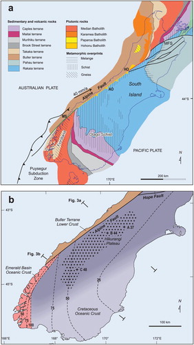
To investigate this deeper crustal structure further, 40 portable broadband seismograph stations were deployed in the southeastern South Island during the period March 2014 to April 2015. Together with data from existing GeoNet stations, the recorded earthquakes enabled detailed 3D seismic tomography. Details of both the distribution of seismograph stations and earthquakes used in the tomographic inversion are given in Reyners et al. (Citation2017a). Because many ray paths from deeper local earthquakes in the Fiordland subduction zone and beneath the Southern Alps are used in the tomographic inversion, there is good resolution of the lower crustal structure (B). In particular, there is a region with Vp > 8.5 km/s at depth, which we can correlate with the thickest part of the Hikurangi Plateau. This layer deepens to both the northwest and southwest. It extends to the northern Fiordland subduction zone, where it impacts the subducted oceanic crust of the Australian Plate, bending it to vertical. In the southeast of the South Island, the edge of the plateau thins towards the Cretaceous oceanic crust on which the plateau was originally emplaced. The dip of this oceanic crust rotates eastwards towards a Gondwana subduction direction (c. north–south), and the seismic tomography tracks subduction of this oceanic crust beneath the 70 km-thick Median Batholith (Reyners et al. Citation2017a).
The crustal root to the Southern Alps defined by seismic tomography overlies the Hikurangi Plateau, and its western and eastern edges appear to be controlled by isobaths on the plateau (B; Reyners et al. Citation2017a). Previous studies of the maximum crustal thickness of the crustal root using seismic refraction SIGHT transects 1 and 2 (Scherwath et al. Citation2003; van Avendonk et al. Citation2004) and a Pn study (Bourguignon et al. Citation2007) are consistent with our interpretation that the crustal root has developed above the plateau. However, all these studies interpreted the base of the crustal root as the Moho of continental crust, whereas Reyners et al. (Citation2017a) interpret this as the top surface of the underlying mafic Hikurangi Plateau. There are hints of higher Vp below this Moho, e.g. Vp up to 8.5 km/s beneath the east coast of the South Island on SIGHT 1 (van Avendonk et al. Citation2004), but generally these studies lack the depth penetration to identify the underlying plateau. High Vp of up to 8.5–8.6 km/s is also required below the Moho from teleseismic P-waves recorded along SIGHT transects 1 and 2, but the shape and position of the high Vp body could not be fixed uniquely (Stern et al. Citation2000). These high Vp are consistent with the tomographic model of Reyners et al. (Citation2017a), where the high Vp Hikurangi Plateau underplates the crustal root of the Southern Alps.
Further evidence for this underplated plateau is provided by subcrustal earthquakes that occur sporadically beneath the Southern Alps. These have been studied previously by Reyners (Citation1987, Citation2005) and Boese et al. (Citation2013). They have now been relocated using the new 3D seismic velocity model (Reyners et al. Citation2017a, figure 6). These events are found to lie mainly in the subducted plateau, with some also in the subducted oceanic crust of the Australian plate. The origin of these subcrustal earthquakes is now understandable, because brittle deformation in both these mafic units can occur at temperatures up to c. 600 °C, in contrast to up to only c. 350 °C in crustal rocks (Chen and Molnar Citation1983).
Formation of the Alpine Fault
It is very difficult to form a long strike-slip fault. Rock mechanics tells us that when a shear fracture forms, the stress field in the fault tip regions will generate local tensile fractures (wing cracks) that will arrest further movement on the shear fracture (see Fossen Citation2010 for a fuller discussion). A long strike-slip fault thus requires some pre-existing structure, such as a long extensional fracture, or an extensive weak structure. Sutherland et al. (Citation2000) have thus proposed that the Alpine Fault and any lithospheric discontinuity was controlled by an Eocene passive margin that separated Paleozoic continental lithosphere of the Challenger Plateau from much younger oceanic lithosphere. The Eocene rift boundary formed by exploiting Cretaceous oceanic transform faults and an older discontinuity within Zealandia, which could be as old as Paleozoic. Similarly, Lamb et al. (Citation2016) have suggested that Cenozoic displacement of > 700 km on the Alpine Fault has reversed > 225 km of sinistral motion on an older Late Cretaceous fault.
Was there such an older fault at the Gondwana margin? Recent seismic tomography in the southern South Island (Reyners et al. Citation2017a) provides some insight into this question. This reveals that the southwestern part of the Hikurangi Plateau was a relatively narrow salient, and the first part to be subducted at the Gondwana margin at c. 105 Ma. This narrow salient indented the margin and is a likely cause of the oroclinal bending of Gondwana terranes we see in the South Island today (A; Mortimer Citation2014). The plateau then rotated clockwise about the salient until the southern edge of the plateau was parallel to subduction strike and subduction ceased at c. 100 Ma. It also led to a concentration of slab pull in the adjacent oceanic crust on both sides of the salient, explaining the episode of basin opening and intraplate magmatism that occurred at the same time (Reyners et al. Citation2017a). This tectonic situation argues against the existence of a lithospheric-scale proto-Alpine fault, such as a transform fault in subducted oceanic crust at the Gondwana margin. Such a fault would have changed subduction dynamics, because it would likely have acted to alleviate both the choking of the Gondwana margin and the episode of failed rifting in adjacent oceanic crust caused by impact of the plateau.
But if there was no pre-existing fault, how was movement on the Alpine Fault initiated at c. 23 Ma (Kamp Citation1986)? The answer lies in the history of plate motions in the Cenozoic. Following choking of the Gondwana margin by the Hikurangi Plateau at c. 100 Ma, the leading subducted oceanic crust necked and finally detached at depth at c. 85 Ma. This initiated the wholesale northward rifting of the New Zealand continent (Zealandia) from the rest of Gondwana. Numerical modelling (van Hunen and Allen Citation2011) indicates that the delay time between first continental collision and slab break-off depends mostly on the strength of the previously subducted oceanic plate, and ranges from 10 Ma (for young, weak slabs) to > 20 Ma (for old, strong slabs). A 15 Ma period between the plateau choking the Gondwana margin and slab break-off would be consistent with this modelling. Prior to slab break-off, wholesale rifting will be inhibited due to a sea anchor force exerted on the slab that resists its lateral motion (Scholz and Campos Citation1995), leading to the episode of failed rifting and intraplate volcanism that followed plateau collision. Then at 53 Ma or shortly after, the ancestors of the modern western Pacific subduction systems were created, and the increase in westward slab pull that was generated can explain the change from northward to westward Pacific plate motion at c. 50 Ma (Sutherland et al. Citation2017). This westward plate motion led to the southwestern salient of the Hikurangi Plateau again lying within a plate boundary zone by c. 40 Ma (Reyners Citation2013).
At this time, westward-dipping Tonga–Kermadec subduction extended southward into northern New Zealand, where reverse faulting and shortening dominated in the overlying plate (Stagpoole and Nicol Citation2008). To the south of New Zealand, Emerald Basin opening started at c. 45 Ma (Sutherland Citation1995). This change from convergence in the north to extension in the south suggests that the c. 35 km-thick plateau salient again resisted subduction. During the period 45–30 Ma, the Pacific/Australia instantaneous rotation pole was close to this plateau salient (Sutherland Citation1995), suggesting that resistance of the plateau to subduction had a first-order effect on plate motions. The plateau salient again appears to have acted as a pivot point on the plate boundary.
By 25 Ma, extensive trench rollback and backarc opening had occurred to the north of New Zealand (A). Given the difficulty of subducting the thick, buoyant Hikurangi Plateau, continued trench rollback to the north would have led to an increasingly curved termination of the Tonga–Kermadec subduction zone against the western edge of the plateau, resulting in high strain. At the same time, the Emerald Basin spreading centre was a weak zone in the oceanic crust to the south. This situation led to conditions conducive to the development of a subduction–transform edge propagator (STEP) fault (Govers and Wortel Citation2005). In this model, the Alpine Fault forms as the subduction zone rolls back by ripping oceanic crust seaward of the trench from the western edge of the plateau. As the trench rolls back, trench suction takes the overlying plate with it, resulting in varied extension in the overlying plate and strike-slip motion on the Alpine Fault (B). Movement of the overlying plate is facilitated by the weak Emerald Basin spreading centre changing to a strike-slip zone. So, in a sense, this is a major southward extension of the Alpine Fault. But because of the presence of the thick and strong Hikurangi Plateau, the northern half of the oceanic crust in the Emerald Basin is subducted beneath Fiordland (B; Reyners Citation2013). The STEP fault model can explain the initiation of not only the Alpine Fault, but also subduction beneath Fiordland, with this subduction being of opposite polarity to that of the Tonga–Kermadec–Hikurangi subduction zone.
Figure 2. Snapshots of the tectonic setting A, just before and B, just after Alpine Fault formation as a STEP fault (after Reyners Citation2013, incorporating new information on the shape of the Hikurangi Plateau from Reyners et al. Citation2017a). TKSZ denotes the Tonga–Kermadec subduction zone. This drove STEP fault formation, rolling back by ripping oceanic crust seaward of the trench from the western edge of the plateau. The background Southwest Pacific plate reconstruction is that of Schellart et al. (Citation2006), with an Australia-fixed reference frame. The Hikurangi Plateau (HP) is shown in purple, with its currently subducted part light, and the portion yet to be subducted dark. The fossil trench where the plateau partly subducted under Gondwana at c. 105–100 Ma is marked by the grey barbed line. The Alpine Fault is shown in red, and the strike-slip fault that formed at the Emerald Basin (EB) spreading centre upon Alpine STEP fault formation is shown in blue.
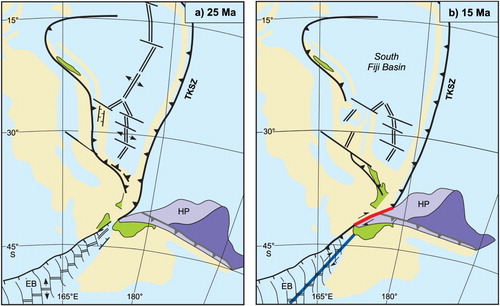
The proposed STEP model explains many features of Alpine Fault development, and a full discussion of these is given in Reyners (Citation2013). Prior to the current episode of plate convergence in the South Island, the western edge of the Hikurangi Plateau and the Alpine Fault were coincident, suggesting a close association between the two. The STEP fault model also explains why the Alpine Fault developed abruptly at c. 23 Ma; why the fault is a lithospheric-scale feature with a finite length of c. 650 km; and why we see a concomitant slab edge in the northernmost South Island (i.e. oceanic crust ripped from the edge of the plateau as the STEP formed; see Reyners Citation2013). Given that STEP fault formation is essentially a transtensional process, it also provides an explanation for the intrusion of lamprophyre dyke swarms into tensional fractures and Riedel shears during the propagation of the Alpine Fault (Cooper et al. Citation1987).
The history of strike-slip motion on the fault
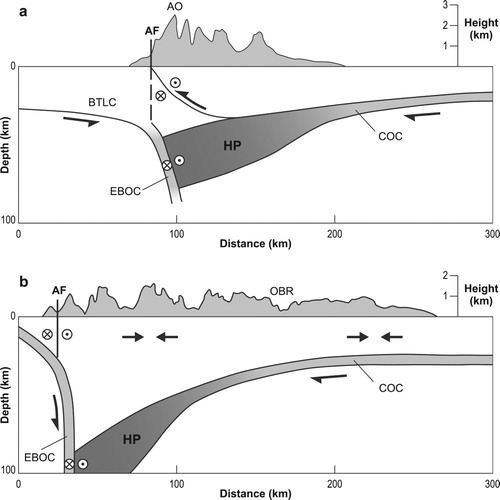
The Alpine Fault formed because the angle of attack of the western edge of the plateau at the subduction zone (i.e. the angle between the plateau edge and the strike of the subduction zone) appears to have been sufficiently large for STEP fault formation (A). When the edge of the plateau became more northerly and thus more parallel to subduction zone strike at c. 15 Ma (B), STEP fault propagation will have stopped. By c. 10 Ma, the western edge of the plateau became parallel to the strike of the subduction zone, and this is when the current (and second) episode of plateau subduction began (Reyners Citation2013). Subduction of the plateau at the Hikurangi subduction zone requires accommodation of crustal collision in the central South Island, where there is no leading oceanic crust to subduct, because it was ripped away during the STEP fault phase of Alpine Fault development. Such collision has been achieved by delamination and subduction of the mafic plateau, and exhumation of the quartzofeldspathic upper crust along the Alpine Fault, uplifting the Southern Alps (Reyners et al. Citation2011, Citation2017a; ).
Figure 3. Depth sections of structure and tectonics in A, central and B, southern parts of the Alpine Fault. The location of the sections is shown in (B). Smoothed topography on each section is from Davey et al. (Citation2007). In A, the dashed line represents the original location of the Alpine STEP fault, which is now inactive. Because of rapid exhumation due to restricted accommodation space above the shallow Hikurangi Plateau (HP), plate motion in the upper crust is accommodated by oblique motion on a listric Alpine Fault. But in the mafic lower crust (EBOC and HP), plate motion is partitioned. In B, exhumation is much less, because of much more space above the HP to accommodate crustal shortening. Here, plate motion in the upper crust is partitioned, with the strike-slip component of plate motion taken up by the Alpine STEP fault. AF, Alpine Fault; AO, Aorangi/Mt Cook; BTLC, Buller Terrane lower crust; COC, Cretaceous oceanic crust; EBOC, Emerald Basin oceanic crust; OBR, Otago basin and range province.
An important consequence of subduction of the Hikurangi Plateau starting at c. 10 Ma is that the development of a subduction décollement above the plateau mechanically favoured deformation within the overlying Australian Plate crust (Reyners Citation2013). Such a décollement is a necessary condition for the development of tectonic block rotations and strike-slip faulting in the shallow part of the subduction zone, as deformation within the plateau itself was precluded because of the strong nature of the thick, mafic plateau. Strike-slip motion on the Awatere Fault of the Marlborough fault system in the northeastern South Island began after 7.4–6.4 Ma (Little and Jones Citation1998), indicating the existence of a subduction décollement under this region by that time. Linking of the Marlborough fault system with the Alpine Fault will have led to a new episode of strike-slip motion on the fault. How strike-slip motion on the Alpine Fault was partitioned between the first c. 8 Ma episode of STEP fault development and the second c. 7 Ma episode of linkage through the Marlborough fault system is an open question. But if the 480 km offset of geological terranes across the fault occurred only during these two episodes, this indicates an average strike-slip rate of c. 32 mm/a. This is close to the relatively constant Late Quaternary strike-slip rate of 27 ± 5 mm/a on the STEP part of the fault (i.e. between Milford Sound and Hokitika) determined by Norris and Cooper (Citation2001), and the relatively constant along-strike dextral slip rate of c. 28 mm/a more recently determined by Barth et al. (Citation2014).
Fault kinematics and slip partitioning
Although the Late Quaternary strike-slip rate on the Alpine Fault is relatively constant, dip-slip rates show considerable variation along strike, rising to a maximum of > 10 mm/a in the central section of the fault and decreasing to zero at the southern end (Norris and Cooper Citation2001). This trend is a direct consequence of the deep 3D crustal structure in the region of the fault (B). Buller Terrane rocks and subducted Eocene oceanic crust to the west of the Alpine Fault STEP provide a near-vertical western buttress to the crustal root of the Southern Alps. This root has only formed in the region where there is shallow underlying Hikurangi Plateau, indicating that the plateau acts as the eastern buttress to the root (A; Reyners et al. Citation2017a). East of the Alpine Fault in (A), the width of the compressional deformation zone (as reflected by smoothed topography) is restricted to this region where the plateau is shallow. South of the crustal root where the plateau and its adjacent Cretaceous oceanic crust deepen, compressional deformation at the plate boundary widens into the thick, weaker Otago Schist, resulting in thrusting and basin and range formation (B). This along-strike variation in deformation in the South Island has previously been attributed to thin, strong lower crust in the north, and thick, weak lower crust in the south (Upton et al. Citation2009). Our model of the deep 3D crustal structure is compatible with that study, insofar as strong Hikurangi Plateau constitutes the lower crust in the north, whereas in the south the plateau deepens and at the same depth as in the north, weaker continental rocks are present.
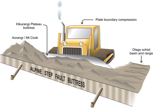
The northwest-dipping plateau beneath the crustal root strikes at c. 220° (Reyners Citation2005), the same strike as that of the plateau in the North Island. In contrast, the straight part of the Alpine Fault strikes at c. 236°. This 16° difference in strike between the two buttresses means there is far less accommodation space for crustal convergence in the north relative to that in the south, leading to the highest uplift and exhumation rates occurring in the northern Aorangi/Mt Cook region in the central part of the Alpine Fault. Seismic reflections east of the central Alpine Fault define a boundary, 20–30 km deep and dipping southeast at 40–60°, which projects to the Alpine Fault at the surface (Davey et al. Citation1995; Kleffmann et al. Citation1998). Also, a bright reflective zone can be traced eastwards from the mid crust into a sub-horizontal zone of strong reflectivity at c. 30 km depth (Okaya et al. Citation2002). In addition, low-frequency earthquakes occur below the seismogenic zone at depths of 17–42 km, on or near the hypothesised deep extent of the Alpine fault, consistent with quasi-continuous shear faulting on the deep extent of the fault (Chamberlain et al. Citation2014; Baratin et al. Citation2018). It is this listric fault that controls convergence in the central section of the Alpine Fault, allowing the delamination of a carapace of schist and greywacke from the Hikurangi Plateau as the plateau itself subducts (A). This delamination model for the central section of the fault bears many resemblances to the original uplift model of Wellman (Citation1979), with the top of the subducted plateau being his ‘anti-fault’. In this central region of the fault, the original STEP fault is now inactive (A).
Our preferred model of the crustal root and uplift and exhumation rates to the east of the fault being a direct consequence of changing accommodation space for a crustal root because of the differences in strike of the Alpine Fault and subducted Hikurangi Plateau is shown schematically in . This model differs from previous interpretations. For example, Little et al. (Citation2005) suggest that at the orogen scale, higher uplift rates throughout the central Southern Alps may be related to a rheologically controlled increase in the convergent velocity of points to the east of the Alpine Fault, associated with a strengthening of the Pacific Plate crust. But there is no clear evidence from seismic tomography (Reyners et al. Citation2017a) for such an along-strike strengthening. Also, Lamb et al. (Citation2015) suggest that the observed crustal root to the Southern Alps is up to twice that predicted by the orthogonal plate convergence since c. 11 Ma. To account for this, it is suggested that a hyperextended margin underwent shallow subduction in the Puysegur subduction zone, and then was dragged over 300 km along the length of the Southern Alps beneath a low-angle (< 20°) section of the Alpine Fault. This study used an initial crustal thickness throughout the southern South Island that was not thicker than that at the coast today (i.e. 25–32 km). But the seismic tomography of Reyners et al. (Citation2017a) shows that the initial crustal thickness to the south was much larger, because of the earlier episode of Gondwana subduction (B). For example, the tomography shows that the Median Batholith in the southernmost South Island is c. 70 km thick, and Cretaceous oceanic crust has been subducted under this.
Figure 4. Cartoon illustrating how crustal deformation in the central South Island is buttressed by both the incoming Hikurangi Plateau (the bulldozer blade) and the Alpine STEP fault (the wall). The angle between these buttresses is 16°. This results in less accommodation space and more exhumation in the Aorangi/Mt Cook region, and more accommodation space and thus less exhumation towards the south. Further south the Hikurangi Plateau deepens as a result its subduction at the Gondwana margin, and the buttressing effect of the plateau is lost. This enables the widening of the zone of active deformation into the Otago schist basin and range.
So how is slip partitioned between the Alpine STEP and listric faults? In the central Alpine Fault, slickenside striations in the fault gouge and stretching lineations in mylonite have an average trend of c. 080°, approximately parallel to the plate motion vector and consistent with oblique slip (Sibson et al. Citation1979; Norris and Cooper Citation1995, Citation2007). So, in this region, the listric fault is clearly weaker than the STEP fault in the brittle crust and is taking up most of the plate motion. This is most likely a result of the high rainfall west of the main divide of the Southern Alps (5–10 m/a; Cox et al. Citation2012). This leads to rapid erosion and exhumation, resulting in thermal weakening along dipping structures in the brittle crust. Koons et al. (Citation2003) have carried out 3D numerical modelling of the obliquely convergent Southern Alps. They have shown that when the upper crust is significantly weakened by exhumation, strike-slip strain abandons the vertical (i.e. STEP) fault and shifts to the dipping structure, combining with the convergent strain to form a single oblique fault that accommodates the plate motion in the upper crust (A). This faulting in the upper crust facilitates the transfer of slip to upper crustal faults of the Marlborough fault system along the northern section of the Alpine Fault (Norris and Cooper Citation2001). In the southern section of the fault, where dip-slip rates on the fault decrease to zero at the southern end, the fault-normal component is taken up by structures further east (Reyners et al. Citation2017a), and the STEP fault is active throughout the upper crust (B). In this region, there is much more accommodation space for the crustal root of the Southern Alps, and hence much less exhumation. In a sense this region corresponds to an early stage of oblique convergence, when boundary-parallel strain is accommodated along a near-vertical structure and boundary-normal strain is concentrated on structures dipping at moderate angles into the orogen (Koons et al. Citation2003).
However, the two components of strain remain separate in the mafic lower crust (i.e. Emerald Basin oceanic crust and Hikurangi Plateau). This means that in this lower crust, slip partitioning of plate motion occurs along the length of the Alpine Fault, just like in the Fiordland subduction zone to the south and the Hikurangi subduction zone to the north (Anderson et al. Citation1993). It is only in the upper crust in the central section of the fault, where uplift rates are high because of the restricted accommodation space for a crustal root, where slip is mostly in the relative plate motion direction. But even in this central section, the STEP fault is still active in partitioning strain in the mafic lower crust.
The strength of the fault
The STEP fault model of Alpine Fault formation presented here suggests that the fault is weak on a lithospheric scale. However, many authors have argued that drag on the fault has produced oroclinal bending of geological terranes into the fault (Kamp Citation1987; Sutherland Citation1999; Mortimer Citation2014; see A), implying that the fault is strong. The recent determination of the shape of the Hikurangi Plateau which impacted the Gondwana subduction zone during the period 105–100 Ma suggests that much of the bending of terranes in the oroclinal bend will have occurred at that time. The first part of the plateau to subduct was a relatively narrow salient, which would have bent terranes ahead of it (Reyners et al. Citation2017a; B). Later subduction of the full lateral extent of the plateau (c. 1600 km) will have caused more regional bending of the Gondwana terranes. But there is also evidence of renewed bending in the Cenozoic. Within 100 km of the Alpine Fault, high Cenozoic brittle strain has resulted in the Murihiku Terrane being represented only as fault slivers, and the tightening of the Taieri–Whakatipu Synform towards the Alpine Fault is likely an expression of Cenozoic bending (Mortimer Citation2014). Reconstruction of the crustal volume balance in the New Zealand region shows that at c. 25 Ma, there was a significant increase in land area, and an increase in the non-rigid deformation of a large region in the centre of Zealandia (Wood and Stagpoole Citation2007). This was also a time of high strain, because continued trench rollback to the north would have led to an increasingly curved termination of the Tonga–Kermadec subduction zone against the western edge of the plateau (A). It is likely that the renewed bending occurred around this time, and that it ceased at c. 23 Ma when high strain at the plate boundary was relieved by development of the Alpine Fault as a STEP fault.
A weak, lithospheric-scale fault will not require a wide zone of shear in the lithospheric mantle. Such a wide zone of shear as has been suggested previously, mainly from shear-wave splitting (Molnar et al. Citation1999). The fast polarization direction from SKS splitting measurements east of the Alpine Fault is oriented approximately northeast (Klosko et al. Citation1999; Savage et al. Citation2007), parallel to the fast polarization direction from SKS in the Hikurangi subduction zone. An abiding problem with interpretation of such shear-wave splitting measurements is where on the ray path the anisotropic regions lie (Savage Citation1999). A tomographic inversion for the 3D distribution of Vp azimuthal anisotropy in the Hikurangi subduction zone beneath the central North Island (Eberhart-Phillips and Reyners Citation2009) has revealed that the largest region of anisotropy is within the subducted slab (i.e. the Hikurangi Plateau), where anisotropy is consistently trench parallel and 5–9% in magnitude. Bending-induced yielding of the plateau as it moves through the trench region provides an explanation for this anisotropy. Full details of the strain rates involved in producing such B-type anisotropy, and why this explanation is preferred to fracture anisotropy or fossil anisotropy are given in Eberhart-Phillips and Reyners Citation2009 (see their section 7.1). Given that the plateau has also been subducted under the Southern Alps (Reyners et al. Citation2017a), a straightforward explanation for the orientation of the fast polarization direction from SKS east of the Alpine Fault is that it similarly represents bending-induced yielding of the subducting plateau there. Shear-wave splitting from local earthquakes (Karalliyadda and Savage Citation2013) similarly indicates a localized high-strain zone in the southern central region of the South Island. Although these authors suggest that this is produced by pervasive shear distributed within a zone extending c. 130 km southeast of the Alpine, bending-induced yielding of the subducting plateau there is again a viable explanation for this result. In the southernmost South Island, the fast direction of anisotropy from local earthquakes rotates into a northerly direction (Karalliyadda and Savage Citation2013). Given that this direction parallels deeper isobaths on the subducted plateau and adjacent oceanic crust (B), bending-induced yielding is again a viable explanation for this anisotropy.
But could there still be a wide zone of shear in the lithospheric mantle below the plateau? Zietlow et al. (Citation2014) and Karalliyadda et al. (Citation2015) suggest that shear-wave splitting measurements in the wider South Island region represent distributed lithospheric deformation and can be modelled as a thin viscous sheet. The Hikurangi Plateau was originally part of the largest oceanic plateau on Earth, the Ontong Java Plateau. Shear-wave splitting measurements and studies of shear wave velocity structure indicate that the Ontong Java Plateau has a thick, compositionally distinct root that diverts asthenospheric mantle flow beneath the Pacific plate (Klosko et al. Citation2001). In addition, Tharimena et al. (Citation2016) have used SS precursors to image discontinuities at 28 ± 4 km (the Moho) and 80 ± 5 km below the Ontong Java Plateau, and suggest that a thick viscous root underlies the plateau. A similar deeper discontinuity has been imaged c. 75 km below the top of the Hikurangi Plateau where it subducts beneath the southern North Island (Stern et al. Citation2015). This suggests that the mantle root below the Hikurangi Plateau is relatively strong and has remained intact through episodes of rifting from its parent Ontong Java Plateau and two episodes of subduction.
So a wide zone of shear in the lithospheric mantle below the plateau appears unlikely. This is consistent with numerical modelling of the Alpine Fault seismic cycle, which predicts a zone of localized ductile creep beneath the part of the fault which slips seismically (Ellis et al. Citation2006a). Numerical modelling also indicates that the mantle lithosphere cannot be deforming over a width greater than c. 100 km (Ellis et al. Citation2006b). Similarly, observed surface velocities from GPS constrain the width of present-day deformation in the lower crust to c. 30 km, and in the upper mantle to c. 100 km (Beavan et al. Citation2007). Thus, the Alpine Fault can be considered a weak fault in relatively strong lithosphere. Indeed, a strong lithosphere beneath the Hikurangi Plateau will have promoted the development of the fault as a STEP fault in the first place.
Implications for plate-boundary deformation and suggestions for further research
Many previous studies of the Alpine Fault have interpreted it as a plate boundary through continental lithosphere, with attendant widespread deformation (Molnar et al. Citation1999). However, the recent 3D seismic tomography results discussed here (Reyners et al. Citation2017a) indicate that the habitat of the fault is quite different, being dominated by large igneous province (Hikurangi Plateau) lithosphere and adjacent oceanic lithosphere. This leads to a much narrower deformation zone. The model of the fault presented here is very similar to that of Norris and Toy (Citation2014), in which the fault partitions at depth into a steep zone extending into the mantle, and the strike-slip shear zone is highly localized.
Geological studies in the southern part of the fault show that ruptures are very regular, with a coefficient of variation of 0.41 and a mean recurrence interval of 291 ± 23 years (Cochran et al. Citation2017). Berryman et al. (Citation2012) ascribe this regular behaviour to a geometrically simple strike-slip fault with high slip rate that works in isolation from other faults. The STEP fault model presented here would suggest slip is highly localized on the Alpine Fault because it is the weakest structure available. A weak fault does not mean it will not produce large earthquakes. Geological studies have suggested the last earthquake on the fault in AD 1717 ruptured at least 380 km along strike (Howarth et al. Citation2014). This event ruptured through the region of high exhumation in the central part of the fault, confirming the suggestion of Sutherland et al. (Citation2007) that this region might not inhibit rupture propagation.
The strong contrast in strength between the thick plateau and adjacent oceanic crust provides a straightforward explanation for many features of the Alpine Fault, including why it formed in the first place. Our ability to image the subducted plateau through 3D seismic tomography has allowed us to track its history back to its formation. It is clear that the plateau has caused havoc many times: first by choking the Gondwana subduction zone, then by producing the Alpine STEP fault, and now by controlling how convergence is accommodated along the length of the fault. The deepening of the plateau to the south provides a straightforward explanation as to why the zone of active deformation doubles in width from the central to the southern South Island – the plateau deepens and thus its buttressing effect on the crustal root of the Southern Alps is removed ().
The role of Hikurangi Plateau subduction on the origin and evolution of the Alpine Fault presented here is put forward as the basis of future work and testing. The earthquake data set of Reyners et al. (Citation2017a) has recently been used to determine the 3D distribution of seismic attenuation (1/Qp and 1/Qs) in the southern South Island (Eberhart-Phillips et al. Citationin revision). This study largely confirms the crustal structure model determined from the 3D distribution of Vp and Vp/Vs. Because the variation in seismic attenuation is larger than the variation in seismic velocity, the crustal structure model can be refined, enabling the Hikurangi Plateau to be distinguished from the adjacent Cretaceous oceanic crust. The Q results also provide insights into fluid and/or temperature conditions in the root of the Southern Alps and confirm that the shape of this crustal root is controlled by both the orientation and depth of the underlying plateau. Studies of receiver functions using the 40 portable broadband stations installed in the southeastern South Island for the study of Reyners et al. (Citation2017a) are also underway. This will build on the previous work by Spasojević and Clayton (Citation2008), who determined receiver functions from a much sparser seismograph network. We expect a significant contrast in seismic impedance at the top of the mafic plateau and adjacent oceanic crust, allowing better definition of the shape of these features.
Acknowledgements
Stimulating discussions and arguments with the late Harold Wellman were the spark for much of the seismological research on the Alpine Fault and wider South Island plate boundary carried out by the author over many years. Very thorough reviews of the original manuscript from the Editor and three reviewers are much appreciated.
Disclosure statement
No potential conflict of interest was reported by the authors.
Additional information
Funding
References
- Anderson H, Webb T, Jackson J. 1993. Focal mechanisms of large earthquakes in the South Island of New Zealand: implications for the accommodation of Pacific-Australia plate motion. Geophys J Int. 115:1032–1054. doi: 10.1111/j.1365-246X.1993.tb01508.x
- Baratin L-M, Chamberlain CJ, Townend J, Savage MK. 2018. Focal mechanisms and inter-event times of low-frequency earthquakes reveal quasi-continuous deformation and triggered slow slip on the deep Alpine Fault. Earth Planet Sci Lett. 484:111–123. doi: 10.1016/j.epsl.2017.12.021
- Barth NC, Kulhanek DK, Beu AG, Murray-Wallace CV, Hayward BW, Mildenhall DC, Lee DE. 2014. New c. 270 kyr strike-slip and uplift rates for the southern Alpine Fault and implications for the New Zealand plate boundary. J Struct Geol. 64:39–52. doi: 10.1016/j.jsg.2013.08.009
- Beavan J, Ellis S, Wallace L, Denys P. 2007. Kinematic constraints from GPS on oblique convergence of the Pacific and Australian plates, central South Island, New Zealand. Geophys Monograph Ser. 175:75–94.
- Berryman KR, Cochran UA, Clark KJ, Biasi GP, Langridge RM, Villamor P. 2012. Major earthquakes occur regularly on an isolated plate boundary fault. Science. 336:1690–1693. doi: 10.1126/science.1218959
- Boese CM, Stern TA, Townend J, Bourguignon S, Sheehan A, Smith EGC. 2013. Sub-crustal earthquakes within the Australia-Pacific plate boundary zone beneath the Southern Alps, New Zealand. Earth Planet Sci Lett. 376:212–219. doi: 10.1016/j.epsl.2013.06.030
- Bourguignon S, Stern TA, Savage MK. 2007. Crust and mantle thickening beneath the southern portion of the Southern Alps, New Zealand. Geophys J Int. 168:681–690. doi: 10.1111/j.1365-246X.2006.03208.x
- Chamberlain CJ, Shelly DR, Townend J, Stern TA. 2014. Low-frequency earthquakes reveal punctuated slow slip on the deep extent of the Alpine Fault, New Zealand. Geochem Geophys Geosys. 15:2984–2999. doi: 10.1002/2014GC005436
- Chen W-P, Molnar P. 1983. Focal depths of intracontinental and intraplate earthquakes and their implications for the thermal and mechanical properties of the lithosphere. J Geophys Res. 88:4183–4214. doi: 10.1029/JB088iB05p04183
- Cochran UA, Clark KJ, Howarth JD, Biasi GP, Langridge RM, Villamor P, Berryman KR, Vandergoes MJ. 2017. A plate boundary earthquake record from a wetland adjacent to the Alpine Fault in New Zealand refines hazard estimates. Earth Planet Sci Lett. 464:175–188. doi: 10.1016/j.epsl.2017.02.026
- Cooper AF, Barreiro BA, Kimbrough DL, Mattinson JM. 1987. Lamprophyre dike intrusion and the age of the Alpine fault, New Zealand. Geology. 15:941–944. doi: 10.1130/0091-7613(1987)15<941:LDIATA>2.0.CO;2
- Cox SC, Stirling MW, Herman F, Gerstenberger M, Ristau J. 2012. Potentially active faults in the rapidly eroding landscape adjacent to the Alpine Fault, central Southern Alps, New Zealand. Tectonics. 31:TC2011. doi:10.1029/2011TC003038.
- Davey FJ, Henyey T, Kleffmann S, Melhuish A, Okaya D, Stern TA, Woodward DJ, Working Group SIGHT. 1995. Crustal reflections from the Alpine fault zone, South Island, New Zealand. New Zeal J Geol Geophys. 38:601–604. doi: 10.1080/00288306.1995.9514689
- Davey FJ, Eberhart-Phillips D, Kohler MD, Bannister S, Caldwell G, Henrys S, Scherwath M, Stern T, van Avendonk H. 2007. Geophysical structure of the Southern Alps Orogen, South Island, New Zealand. Geophys Monograph Ser. 175:47–73.
- DeMets C, Gordon RG, Argus DF. 2010. Geologically current plate motions. Geophys J Int. 181:1–80. doi: 10.1111/j.1365-246X.2009.04491.x
- Eberhart-Phillips D, Bannister S. 2002. Three-dimensional crustal structure in the Southern Alps region of New Zealand from inversion of local earthquake and active source data. J Geophys Res. 107:2262. doi:10.1029/2001JB000567
- Eberhart-Phillips D, Chadwick M, Bannister S. 2008. Three-dimensional attenuation structure of central and southern South Island, New Zealand, from local earthquakes. J Geophys Res. 113:B05308. doi:10.1029/2007JB005359.
- Eberhart-Phillips D, Reyners M. 2009. Three-dimensional distribution of seismic anisotropy in the Hikurangi subduction zone beneath the central North Island, New Zealand. J Geophys Res. 114:B06301. doi:10.1029/2008JB005947.
- Eberhart-Phillips D, Reyners M, Upton P, Gubbins D. in revision. Insights into the crustal structure and tectonic history of the southern South Island, New Zealand, from the 3-D distribution of P- and S-wave attenuation. In revision for Geophys J Int.
- Ellis S, Beavan J, Eberhart-Phillips D, Stöckhert B. 2006a. Simplified models of the Alpine Fault seismic cycle: stress transfer in the mid-crust. Geophys J Int. 166:386–402. doi: 10.1111/j.1365-246X.2006.02917.x
- Ellis S, Beavan J, Eberhart-Phillips D. 2006b. Bounds on the width of mantle lithosphere flow derived from surface geodetic measurements: application to the central Southern Alps, New Zealand. Geophys J Int. 166:403–417. doi: 10.1111/j.1365-246X.2006.02918.x
- Fossen H. 2010. Structural geology. Cambridge: Cambridge University Press; p. 360.
- Govers R, Wortel MJR. 2005. Lithosphere tearing at STEP faults: response to edges of subduction zones. Earth Planet Sci Lett. 236:505–523. doi: 10.1016/j.epsl.2005.03.022
- Howarth JD, Fitzsimons SJ, Norris RJ, Jacobsen GE. 2014. Lake sediments record high intensity shaking that provides insight into the location and rupture length of large earthquakes on the Alpine Fault, New Zealand. Earth Planet Sci Lett. 403:340–351. doi: 10.1016/j.epsl.2014.07.008
- Kamp PJJ. 1986. The mid-Cenozoic challenger rift system of western New Zealand and its implications for the age of Alpine Fault inception. Geol Soc Am Bull. 97:255–281. doi: 10.1130/0016-7606(1986)97<255:TMCRSO>2.0.CO;2
- Kamp PJJ. 1987. Age and origin of the New Zealand Orocline in relation to Alpine Fault movement. J Geol Soc. 144:641–652. doi: 10.1144/gsjgs.144.4.0641
- Karalliyadda SC, Savage MK. 2013. Seismic anisotropy and lithospheric deformation of the plate-boundary zone in South Island, New Zealand: inferences from local S-wave splitting. Geophys J Int. 193:507–530. doi: 10.1093/gji/ggt022
- Karalliyadda SC, Savage MK, Sheehan A, Collins J, Zietlow D, Shelley A. 2015. S-wave splitting in the offshore South Island, New Zealand: insights into plate-boundary deformation. Geochem Geophys Geosys. 16:2829–2847. doi: 10.1002/2015GC005882
- Kleffmann S, Davey F, Melhuish A, Okaya D, Stern T, SIGHT team. 1998. Crustal structure in the central South Island, New Zealand, from the Lake Pukaki seismic experiment. New Zeal J Geol Geophys. 41:39–49. doi: 10.1080/00288306.1998.9514789
- Klosko ER, Russo RM, Okal EA, Richardson WP. 2001. Evidence for a rheologically strong chemical mantle root beneath the Ontong-Java Plateau. Earth Planet Sci Lett. 186:347–361. doi: 10.1016/S0012-821X(01)00235-7
- Klosko ER, Wu FT, Anderson HJ, Eberhart-Phillips D, McEvilly TV, Audoine E, Savage MK, Gledhill KR. 1999. Upper mantle anisotropy in the New Zealand region. Geophys Res Lett. 26:1497–1500. doi: 10.1029/1999GL900273
- Koons PO, Norris RJ, Craw D, Cooper AF. 2003. Influence of exhumation on the structural evolution of transpressional plate boundaries: an example from the Southern Alps, New Zealand. Geology. 31:3–6. doi: 10.1130/0091-7613(2003)031<0003:IOEOTS>2.0.CO;2
- Lamb S, Mortimer N, Smith E, Turner G. 2016. Focusing of relative plate motion at a continental transform fault: Cenozoic dextral displacement >700 km on New Zealand’s Alpine Fault, reversing >225 km of late cretaceous sinistral motion. Geochem Geophys Geosys. 17:1197–1213. doi:10.1002/2015GC006225.
- Lamb S, Smith E, Stern T, Warren-Smith E. 2015. Continent-scale strike-slip on a low-angle fault beneath New Zealand’s Southern Alps: implications for crustal thickening in oblique collision zones. Geochem Geophys Geosys. 16:3076–3096. doi: 10.1002/2015GC005990
- Little TA, Cox S, Vry JK, Batt G. 2005. Variations in exhumation level and uplift rate along the oblique-slip Alpine Fault, central Southern Alps, New Zealand. Geol Soc Am Bull. 117:707–723. doi: 10.1130/B25500.1
- Little TA, Jones A. 1998. Seven million years of strike-slip and related off-fault deformation, northeastern Marlborough fault system, South Island, New Zealand. Tectonics. 17:285–302. doi: 10.1029/97TC03148
- Love H, LeGood M, Stuart G, Reyners M, Eberhart-Phillips D, Gubbins D. 2015. Fast P-wave precursors in New Zealand: high velocity material associated with the subducted Hikurangi Plateau. Geophys J Int. 202:1223–1240. doi: 10.1093/gji/ggv205
- Molnar P, Anderson HJ, Audoine E, Eberhart-Phillips D, Gledhill KR, Klosko ER, McEvilly TV, Okaya D, Savage MK, Stern T, Wu T. 1999. Continuous deformation versus faulting through the continental lithosphere of New Zealand. Science. 286:516–519. doi: 10.1126/science.286.5439.516
- Mortimer N. 2004. New Zealand’s geological foundations. Gondwana Res. 7:261–272. doi: 10.1016/S1342-937X(05)70324-5
- Mortimer N. 2014. The oroclinal bend in the South Island, New Zealand. J Struct Geol. 64:32–38. doi: 10.1016/j.jsg.2013.08.011
- Mortimer N, Davey FJ, Melhuish A, Yu J, Godfrey NJ. 2002. Geological interpretation of a deep seismic reflection profile across the Eastern Province and Median Batholith, New Zealand: crustal architecture of an extended Phanerozoic convergent Orogen. New Zeal J Geol Geophys. 45:349–363. doi: 10.1080/00288306.2002.9514978
- Neal CR, Mahoney JJ, Kroenke LW, Duncan RA, Petterson MG. 1997. The Ontong Java Plateau. Geophys Monogr. 100:183–216.
- Norris RJ, Cooper AF. 1995. Origin of small-scale segmentation and transpressional thrusting along the Alpine Fault, New Zealand. Geol Soc Am Bull. 107:231–240. doi: 10.1130/0016-7606(1995)107<0231:OOSSSA>2.3.CO;2
- Norris RJ, Cooper AF. 2001. Late quaternary slip rates and slip partitioning on the Alpine Fault, New Zealand. J Struct Geol. 23:507–520. doi: 10.1016/S0191-8141(00)00122-X
- Norris RJ, Cooper AF. 2007. The Alpine Fault, New Zealand: surface geology and field relationships. Geophys Monogr Ser. 175:157–175.
- Norris RJ, Toy VJ. 2014. Continental transforms: a view from the Alpine Fault. J Struct Geol. 64:3–31. doi: 10.1016/j.jsg.2014.03.003
- Okaya D, Henrys S, Stern T. 2002. Double-sided onshore–offshore seismic imaging of a plate boundary: “super-gathers” across South Island, New Zealand. Tectonophysics. 355:247–263. doi: 10.1016/S0040-1951(02)00145-2
- Reyners M. 1987. Subcrustal earthquakes in the central South Island, New Zealand, and the root of the Southern Alps. Geology. 15:1168–1171. doi: 10.1130/0091-7613(1987)15<1168:SEITCS>2.0.CO;2
- Reyners M. 2005. The 1943 Lake Hawea earthquake—A large subcrustal event beneath the Southern Alps of New Zealand. New Zeal J Geol Geophys. 48:147–152. doi: 10.1080/00288306.2005.9515105
- Reyners M. 2013. The central role of the Hikurangi Plateau in the Cenozoic tectonics of New Zealand and the Southwest Pacific. Earth Planet Sci Lett. 361:460–468. doi: 10.1016/j.epsl.2012.11.010
- Reyners M, Eberhart-Phillips D, Bannister S. 2011. Tracking repeated subduction of the Hikurangi Plateau beneath New Zealand. Earth Planet Sci Lett. 311:165–171. doi: 10.1016/j.epsl.2011.09.011
- Reyners M, Eberhart-Phillips D, Upton P, Gubbins D. 2017a. Three-dimensional imaging of impact of a large igneous province with a subduction zone. Earth Planet Sci Lett. 460:143–151. doi: 10.1016/j.epsl.2016.12.025
- Reyners M, Eberhart-Phillips D, Bannister S. 2017b. Subducting an old subduction zone sideways provides insights into what controls plate coupling. Earth Planet Sci Lett. 466:53–61. doi: 10.1016/j.epsl.2017.03.004
- Saunders AD, Tarney J, Kerr AC, Kent RW. 1996. The formation and fate of large oceanic igneous provinces. Lithos. 37:81–95. doi: 10.1016/0024-4937(95)00030-5
- Savage MK. 1999. Seismic anisotropy and mantle deformation: what have we learned from shear wave splitting? Rev Geophys. 37:65–106. doi: 10.1029/98RG02075
- Savage MK, Duclos M, Marson-Pidgeon K. 2007. Seismic anisotropy in South Island, New Zealand. Geophys Monograph Ser. 175:95–114.
- Schellart WP, Lister GS, Toy VG. 2006. A late Cretaceous and Cenozoic reconstruction of the Southwest Pacific region: tectonics controlled by subduction and slab rollback processes. Earth Sci Rev. 76:191–233. doi: 10.1016/j.earscirev.2006.01.002
- Scholz CH, Campos J. 1995. On the mechanism of seismic decoupling and back arc spreading at subduction zones. J Geophys Res. 100:22103–22115. doi: 10.1029/95JB01869
- Scherwath M, Stern T, Davey F, Okaya D, Holbrook WS, Davies R, Kleffmann S. 2003. Lithospheric structure across oblique continental collision in New Zealand from wide-angle P-wave modelling. J Geophys Res. 108:B12,2566. doi: 10.1029/2002JB002286
- Sibson RH, White SH, Atkinson BK. 1979. Fault rock distribution and structure within the Alpine Fault zone: a preliminary account. R Soc New Zeal Bull. 18:55–65.
- Spasojević S, Clayton RW. 2008. Crustal structure and apparent tectonic underplating from receiver function analysis in South Island, New Zealand. J Geophys Res. 113:B04307. doi:10.1029/2007JB005166.
- Stagpoole V, Nicol A. 2008. Regional structure and kinematic history of a large subduction back thrust: Taranaki Fault, New Zealand. J Geophys Res. 113:B01403. doi:10.1029/2007JB005170.
- Stern T, Molnar P, Okaya D, Eberhart-Phillips D. 2000. Teleseismic P wave delays and modes of shortening the mantle lithosphere beneath South Island, New Zealand. J Geophys Res. 105:21615–21631. doi: 10.1029/2000JB900166
- Stern TA, Henrys SA, Okaya D, Louie JN, Savage MK, Lamb S, Sato H, Sutherland R, Iwasaki T. 2015. A seismic reflection image of the base of a tectonic plate. Nature. 518:85–88. doi: 10.1038/nature14146
- Sutherland R. 1995. The Australia-Pacific boundary and Cenozoic plate motions in the SW Pacific: some constraints from Geosat data. Tectonics. 14:819–831. doi: 10.1029/95TC00930
- Sutherland R. 1999. Cenozoic bending of New Zealand basement terranes and Alpine Fault displacement: a brief review. New Zeal J Geol Geophys. 42:295–301. doi: 10.1080/00288306.1999.9514846
- Sutherland R, Collot J, Bache F, Henrys S, Barker D, Browne GH, Lawrence MJF, Morgans HEG, Hollis CJ, Clowes C, et al. 2017. Widespread compression associated with Eocene Tonga-Kermadec subduction initiation. Geology. 45:355–358. doi: 10.1130/G38617.1
- Sutherland R, Davey F, Beavan J. 2000. Plate boundary deformation in South Island, New Zealand, is related to inherited lithospheric structure. Earth Planet Sci Lett. 177:141–151. doi: 10.1016/S0012-821X(00)00043-1
- Sutherland R, Eberhart-Phillips D, Harris RA, Stern T, Beavan J, Ellis S, Henrys S, Cox S, Norris RJ, Berryman KR, et al. 2007. Do great earthquakes occur on the Alpine fault in central South Island, New Zealand? Amer Geophys Union Monograph. 175:235–251.
- Tharimena S, Rychert CA, Harmon N. 2016. Seismic imaging of a mid-lithospheric discontinuity beneath Ontong Java Plateau. Earth Planet Sci Lett. 450:62–70. doi: 10.1016/j.epsl.2016.06.026
- Upton P, Koons PO, Craw D, Henderson CM, Enlow R. 2009. Along-strike differences in the Southern Alps of New Zealand: consequences of inherited variation in rheology. Tectonics. 28:TC2007. doi:10.1029/2008TC002353.
- van Avendonk HJA, Holbrook WS, Okaya D, Austin J, Davey F, Stern T. 2004. Continental crust under compression: A seismic refraction study of SIGHT Transect 1, South Island, New Zealand. J Geophys Res. 109:B06302. doi: 10.1029/2003JB002790
- van Hunen J, Allen MB. 2011. Continental collision and slab break-off: a comparison of 3-D numerical models with observations. Earth Planet Sci Lett. 302:27–37. doi: 10.1016/j.epsl.2010.11.035
- Wellman H. 1979. An uplift map of the South Island of New Zealand, and a model for uplift of the Southern Alps. Bull R Soc New Zeal. 18:13–20.
- Wellman H, Willett RW. 1942. The geology of the west coast from Abut head to Milford sound, Part I. Trans R Soc New Zeal. 71:282–306.
- Wood RA, Stagpoole VM. 2007. Validation of tectonic reconstructions by crustal volume balance: New Zealand through the Cenozoic. Geol Soc Am Bull. 119:933–943. doi: 10.1130/B26018.1
- Zietlow DW, Sheehan AF, Molnar PH, Savage MK, Hirth G, Collins JA, Hager BH. 2014. Upper mantle seismic anisotropy at a strike-slip boundary: South Island, New Zealand. J Geophys Res. 119:1020–1040. doi: 10.1002/2013JB010676