
ABSTRACT
The Alpine Fault is the most major source of seismic hazard in the South Island of New Zealand, with the potential to produce a magnitude 8+ earthquake and associated ground shaking and co-seismic hazards (e.g. landslides and liquefaction), and severe, widespread and long-term impacts throughout southern and central New Zealand. Scientific investigation of the hazard and risk posed by the Alpine Fault to New Zealand society over recent decades, and several recent large earthquake disasters in New Zealand (the 2010–2011 Canterbury earthquake sequence and the 2016 Kaikoura earthquake) have created considerable national, regional and local awareness and motivation to boost disaster risk management efforts for major earthquakes, further emphasising the importance of Project AF8’s objectives. In July 2016, a project to develop a collective South Island emergency response plan was initiated, in partnership with all South Island Civil Defence Emergency Management (CDEM) groups and the Alpine Fault research community. This has become known as Project AF8 (Alpine Fault, magnitude 8). We describe the development and outcomes of the project, towards enhancing societal resilience to a future Alpine Fault earthquake.
Introduction
New Zealand is a geologically active country, located across an active tectonic plate boundary.Footnote1 The 2010 National Seismic Hazard Model (Stirling et al. Citation2012) describes the seismic hazard throughout the country as spatially related to the subduction and transform sections of the plate boundary through the axial backbone of New Zealand from Fiordland to Cook Strait and up to East Cape ().
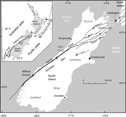
Figure 1. Major active faults of the South Island focusing on the Alpine Fault and its continuation northeastward as the Marlborough Fault System (MFS) and Wairau Fault. The AlpineF2 K source is shown in bold. Inset, Tectonic setting of New Zealand, with relative plate motions across the Australian–Pacific plate boundary.
The Alpine Fault represents the most major element of seismic hazard in the South Island of New Zealand (Stirling et al. Citation1998). The Alpine Fault’s uniquely long paleoseismic record shows 27 rupture events over the past 8000 years (Berryman et al. Citation2012b; Cochran et al. Citation2017), with a recurrence interval of around 300 years (Clark et al. Citation2013). The last event was in approximately AD 1717, which implies that the Alpine Fault is late in its current seismic cycle. According to Cochran et al. (Citation2017), the next Alpine Fault earthquake has a high probability of occurring within the lifetimes of many New Zealanders.
The Alpine Fault is considered to be capable of generating a great (MW > 8) earthquake in future, based on the interpretation of geological data and empirical scaling relationships (Stirling et al. Citation2012). A great Alpine Fault earthquake presents a risk of national significance (Stirling et al. Citation1998; Norris and Cooper Citation2001; Sutherland et al. Citation2007; Dowrick and Rhoades Citation2011; Berryman et al. Citation2012b; Bradley et al. Citation2017; Cochran et al. Citation2017), that will likely cause many casualties (deaths and injuries), substantial damage and disruption to the built environment across the South Island (particularly within the West Coast, inland Canterbury/Otago, northwest Southland and southwest Nelson regions), and substantial direct and indirect social and economic impacts across the country, including Wellington and the lower North Island. Previous major (MW 7.8–8.2) earthquakes in New Zealand have caused considerable impacts, with several in the latter part of the 1800s and first half of the 1900s causing hundreds of fatalities, damage and disruption to buildings and critical infrastructure networks, and many billions of dollars of damage (adjusted to present-day values; ICNZ Citation2017; Stevenson et al. Citation2017). Important lessons can be drawn from the 2016 MW7.8 Kaikoura earthquake which caused severe impacts to distributed infrastructure and rural communities due to ground damage from fault rupture, landslides and liquefaction. Additionally, building damage and significant business disruption in Wellington city due to ground shaking and liquefaction highlighted the widespread, complex and locally unique direct, indirect and intangible impacts of large magnitude earthquakes in New Zealand (Wotherspoon et al. Citation2017).
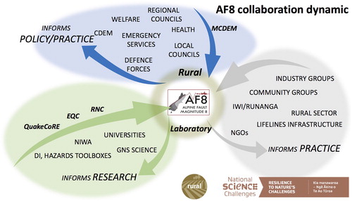
Project AF8 is a 3-year project that focuses on preparing for an Alpine Fault magnitude 8 earthquake. The project reaches across traditional silos of policy, practice and research to collectively address a common objective: to improve the ability of Civil Defence Emergency Management (CDEM) groups, infrastructure utilities, welfare organisations and communities to respond to future major earthquakes within the South Island of New Zealand. An event of this scale will require a collaborative response across regional boundaries, so a major focus within the project is to build relationships and increase collaboration. The project is led by CDEM Southland, on behalf of the six regional South Island CDEM groups, and is funded by the Ministry of Civil Defence & Emergency Management (MCDEM) Resilience Fund (2016–2019), with substantial co-funded support from scientific research programmes (National Science Challenge, Resilience to Nature’s Challenges, QuakeCoRE and the Natural Hazards Research Platform), institutions (the Earthquake Commission, central and local government, universities, Crown Research Institutes), and various non-government organisations. The collaboration dynamic is presented in .
Figure 2. Collaboration dynamic across the domains of policy, research and practice that developed during Project AF8. CDEM, Civil Defence Emergency Management; EQC, Earthquake Commission; NGO, non-governmental organisation; RNC, Resilience to Nature's Challenges.
This paper first outlines both global and national frameworks and key initiatives that focus on reducing disaster risk in New Zealand and elsewhere. We then outline the collaborative Project AF8 planning process and describe the hazard scenario that informed development of the South Island Alpine Fault Earthquake Response (SAFER) plan. Three major outputs of the project are described, including the SAFER plan, the contribution to advancing Alpine Fault research, and efforts to build community resilience through engagementFootnote2 and outreachFootnote3.
Project AF8 within the disaster risk management context in New Zealand
Project AF8 reflects New Zealand and global efforts to reduce disaster risk. The Sendai Framework for Disaster Risk Reduction (2015–2030) calls for greater collaboration among agencies and sectors to ‘prevent, prepare for, respond to, and recover from disasters’ (Aitsi-Selmi et al. Citation2015, p. 165), and encourages the use of disaster risk science to inform disaster risk reduction efforts. The New Zealand government is a signatory to the Sendai Framework, and as such prioritises disaster risk reduction efforts to reduce losses and improve societal outcomes of future disasters. The use of risk scenarios, such as the Alpine Fault hazard scenario, is seen as important for determining future risks and working to reduce them (UNISDR Citation2015a).
Of specific relevance to Project AF8, the framework describes the need to ‘strengthen disaster risk governance and coordination across relevant institutions and sectors and the full and meaningful participation of relevant stakeholders at appropriate levels’ (UNISDR Citation2015b). Knowledge productionFootnote4 (which includes scientific, social and cultural knowledge) to reduce disaster risk is challenging, particularly in operationalising hazard science at the science–policy–practice interface (Gaillard and Mercer Citation2013; Weichselgartner and Pigeon Citation2015). Weichselgartner and Pigeon (Citation2015, p. 115) suggest the next steps in disaster risk reduction require ‘a shift in focus from the production of risk information per se towards co-produced risk knowledge that is understandable and actionable by different kinds of users’. Project AF8, in part, answers the call for co-produced knowledge for a hazard of national significance.
Most previous hazard planning developed by CDEM in New Zealand has used a functional and generic ‘all-hazards’ approach, where available resources are systematically coordinated using the roles, processes and structures of the Coordinated Incident Management System (CIMS) (DPMC Citation2014) and the provision of the National CDEM Plan (MCDEM Citation2015a) in response to hazards events. Analyses of ‘all-hazards’ disaster response experiences domestically (Mitchell and Brunsdon Citation2012) and internationally (Gregory Citation2015) have found that compared with single-agency focused planning, the ‘all-hazards’ approach has merits in providing the framework for more effective multi-agency responses, but still fails to address variability in contributing factors, complex consequences and the need for specialist response knowledge for different hazards. To address these shortcomings, some New Zealand projects have used a collaborative, risk-informed approach to multi-agency response planning. These include the Wellington Earthquake National Initial Response Plan (WENIRP, first published in 2010 prior to the 2010–2012 Canterbury earthquake sequence and updated in 2017, Ministry of Civil Defence & Emergency Management Citation2017); the Northern and Southern Ruapehu Lahar Response Plans (developed for the 2007 dam break lahar, Keys and Green Citation2008; Becker et al. Citation2018); and the subsequent Central Plateau Volcanic Advisory Group (established in 2007).
Previous research in a New Zealand context has highlighted the benefits of agency collaboration in understanding hazard impacts, developing readiness and response plans, and for effective response in an emergency (Paton et al. Citation1999; Ronan et al. Citation2000; Becker et al. Citation2018). Beaven et al. (Citation2016) describes such collaborative arrangements as ‘boundary organisations’ that are ‘used to manage the intersection or boundary, between scientific and policy domains, with the aim of facilitating the joint construction of knowledge to enrich policy and other decision making’. There are obvious challenges and potential tensions in working across domains; for example, research and practice/policy timeframes for delivery are often at odds, given the lengthy research schedules of field or laboratory work and analysis, followed by slow publication processes. This is in stark contrast to the rapid needs of practice and policy organisations for real time, demand-driven outputs (Beaven et al. Citation2016). Project AF8 was subject to this tension. For example, the scenario needed to be developed and delivered within 3 months of project initiation, requiring the consensus of 30 participating scientists (concerns about communicating uncertainties and wanting more data for model verification presented particular challenges). However, using a scenario approach ameliorated these issues by framing the Project AF8 scenario report as: (1) a scientifically informed estimate; and (2) a ‘living document’, allowing updates and iterations to be included as they became available.
The Project AF8 structure and format draw upon a number of existing multi-agency New Zealand initiatives focused on natural hazard impacts and risks (). All three of the regional hazard initiatives can be described as boundary organisations that focus, to a greater or lesser degree, on developing interdisciplinary research programmes to generate new knowledge, working across institutions more effectively and enhancing societal resilience through outreach and engagement. Project AF8 has learnt and continues to learn much from these previous efforts as it builds long-term plans and capacity for Alpine Fault science, policy and practice collaboration into the future.
Table 1. Multi-agency, interdisciplinary, collaborative natural hazard risk research–practice–policy initiatives in New Zealand.
Project AF8: structure and process
Project AF8 comprises two collaborative and integrated workstreams: ‘Risk’ and ‘Response’ (). The Risk workstream focused initially on using available science to generate a credible and realistic Alpine Fault hazard scenario. Thanks to decades of prior research activity, the available scientific knowledge was sufficient to develop a timely and credible consensus understanding of the fundamental earthquake geology, seismology and geomorphic hazard science relating to the Alpine Fault. Providing a scenario was possible with little additional research effort, which built on recent scenarios (including Te Ripahapa by Robinson et al. Citation2014), and was completed in October 2016 (Orchiston et al. Citation2016). The impact and consequences stemming from the Alpine Fault scenario were then developed into high level, semi-quantitative impact assessments (at the South Island scale) for distributed infrastructure and buildings. Qualitative impact assessments for organisational, economic and psychosocial impacts were also completed. For the Response workstream an expert panel approach was used to develop largely qualitatively derived, bespoke, impact scenarios for each CDEM region, for exercising at seven regional workshops (November 2016–June 2017). These tailored assessments benefitted considerably from a co-creation method of partnership between researchers and end users, involving close collaboration and connection between scientists and emergency managers during the research process.
Figure 3. Conceptual model of the Risk and Response workstreams for Project AF8. CDEM, Civil Defence Emergency Management; CRI, Crown Research Institute; MCDEM, Ministry of Civil Defence & Emergency Management.
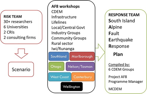
The seven regional CDEM workshops were designed to identify the full suite of response issues, resource needs and actions, both regionally and for the South Island collectively, for the first 7 days after the initial rupture. More than 500 representatives from CDEM groups, partner agencies and organisations attended the workshops in Southland, Otago, Canterbury, West Coast, Nelson–Tasman, Marlborough and Wellington (where national agencies exercised the scenario). Findings and input from the regional workshops have informed development of the SAFER plan, the major year 2 output of Project AF8, due to be completed in early 2018. Year 3 of Project AF8 will continue to outreach and engage with at-risk communities, socialise the SAFER plan and continue to inform the research agenda for Alpine Fault science research investment.
Scenario-building: the Alpine Fault hazard and impact model
Development of the Project AF8 scenario required a structured approach that was informed by the best available science and was executed in a timely manner. Development of scenarios for emergency management planning is very common and numerous frameworks are available (Paton et al. Citation1999; Smith et al. Citation1999; Preuss and Godfrey Citation2006; Robinson et al. Citation2014; GFDRR Citation2016), which all emphasise the need to have a flexible and adaptable framework focused on the local risk context and user and/or application requirements. Development of the AF8 scenario emphasised the requirement of: (1) being underpinned by a credible geophysical scenario; and (2) assessing societal impacts in space and time, including casualties (physical and psychosocial states), functional state of the built environment (including loss of service to essential services and habitability), and disruption to organisations. Economic impacts were not considered a high priority given the short-term response planning focus of SAFER.
Previous Alpine Fault scenarios were built on during the process, with the Te Ripahapa exercise by Robinson et al. (Citation2014) and the Economics of Resilient Infrastructure scenarios (Robinson et al. Citation2015) forming much of the foundation. It was considered essential that a credible geophysical scenario be used within the project, to reflect best current knowledge of the most likely source mechanism for a future event, as well as the geomorphic consequences.
In August 2016, a workshop was held in Christchurch with 30 Alpine Fault researchers, representing six universities, two Crown Research Institutes, and two consulting firms, supported by experienced emergency managers. The broad range of institutional involvement was deliberate, to: (1) access the best scientific information available, which was important for users to view the scenario as credible; and (2) ensure Alpine Fault earthquake process, hazard and impact/risk scientists and engineers felt were closely engaged in the project.
Three teams were formed based on expertise across (1) earthquake source (e.g. rupture geometry and displacements, ground motions, hypocentre location, directivity, ground motions), (2) geomorphic consequences (e.g. landslides, liquefaction) and (3) societal impacts (e.g. impacts on the built and social environments) (). The scenario report was then developed by the leads from each team in the weeks following the workshop. We strongly acknowledge that the next Alpine Fault event will be different, perhaps very different, from this scenario. Therefore, planning using this scenario should be generic and formulated in terms of capability development and adaptability.
Figure 4. Project AF8 process model used to develop the Alpine Fault scenario in August 2016.
Geophysical scenario
The workshop was successful in its aims of developing a relatively comprehensive geophysical (geological, seismological and geomorphological) scenario, known as the ‘hazard scenario’. The final Alpine Fault ‘hazard scenario’ document was submitted for peer review in October 2016 and confirmed as the first complete draft in November 2016 (Orchiston et al. Citation2016). To achieve this within and immediately following a single workshop was a credit to the excellent science available and the collaborative, goodwill approach taken by the workshop participants. We note that several key gaps or areas of high uncertainty were identified and only crudely resolved for the scenario, including spatio-temporal distribution of the likely aftershock sequence and spatio-temporal distribution of secondary hazards (although adequate co-seismic landslide distribution models were identified, these did not adequately inform consequential sediment movement and flooding); and many scientists were cautious (even concerned) about the lack of control on uncertainty.
Impacts scenario
The workshop was less successful in developing a full societal impact scenario, although arguably made more progress in identifying the requirements of CDEM practitioners from disaster scientists and vice versa (i.e. aspects of co-creation). The central discussion that occurred was identifying the needs of the CDEM practitioners and attempting to map or translate these into what impact/risk assessment modelling was possible from scientists under the short time frame available. Lessons from previous disasters and projects similar to Project AF8 had suggested that specialised, sector-specific impact information was required to inform pre- and post-event disaster risk management (GFDRR Citation2016; Beaven et al. Citation2016; Deligne et al. Citation2017 and references therein). However, several key lessons rapidly emerged in which disaster impact/risk assessment scientists struggled to articulate what outputs could be provided and in what format. In some cases, there was simply no impact model immediately available (due to a lack of input data availability or a model simply did not exist) and in others cases the available impact models did not meet needs. CDEM practitioner users did not necessarily know what was possible from the impact/risk, modelling, nor what outputs they wanted, until they saw some of the outputs. Highly fruitful discussions took place; it rapidly emerged that a more structured, iterative approach to identify and engender co-created impact assessment modelling may have been more useful. However, this was challenging given the very short time frames available. Despite this, the process has been hugely valuable for both scientists and end-users, sparking a range of improvements and new impact models.
The second major challenge for developing the impacts scenario in a timely manner was the need to wait for the geophysical scenario to be finalised. Spatio-temporal hazard intensity footprints are typically the required input for impact modelling and here it was time consuming to convert the relevant aspects of the geophysical scenarios into the required formats for modelling; in some cases, they were not available from the geophysical scenario (e.g. aftershock sequence; see Determination of the earthquake source).
In the interests of time, an Expert Panel approach to defining critical impacts based on the hazard scenario was undertaken to inform the response planning. The panel, comprising natural hazard and disaster physical and social scientists, and emergency managers, convened before each regional workshop to identify region-specific, societal consequences that would pose challenges for CDEM groups during the first 7 days after a major Alpine Fault event, based on the Alpine Fault hazard scenario. This approach allowed each region to have a targeted, realistic table-top exercise, to test and extend their understanding of how to respond to an Alpine Fault earthquake, and to inform the SAFER planning process. This approach strongly assisted generating buy-in and engagement during and following the workshops, but due to the bespoke regional approach created difficulties producing an overall consistent scenario that relates between regions.
Outline of the Alpine Fault scenario
Determination of the earthquake source
The active northeast-striking, southeast-dipping Alpine Fault traverses the length of the South Island, extending from offshore of Fiordland to Cook Strait (Berryman et al. Citation1992; Langridge et al. Citation2016b; ). In the National Seismic Hazard Model (NSHM), the Alpine Fault is divided into several source segments, each of which defines a potential MW 7.4–8.3 earthquake (Stirling et al. Citation2012). The NSHM constructs simulated earthquakes from parameters of fault length and width, sense and rate of movement, and dip and dip direction. For the AF8 scenario, rupture of the central and southern segments (Alpine F2 K source in the NSHM) of the fault defines the earthquake mainshock. The Alpine F2 K (Fiordland to Kelly) source is 411 km in length from offshore of Charles Sound to near Hokitika (), and based on magnitude-scaling relationships could rupture in MW 7.9–8.3 earthquakes (De Pascale and Langridge Citation2012). The AF8 scenario causes 7–9 m of maximum horizontal slip and 1–2 m of vertical motion across the fault (Berryman et al. Citation2012a). For more details, we refer the reader to the AF8 source scenario described in detail in Orchiston et al. (Citation2016).
The primary effects from the earthquake come from strong ground motions. Rupture of the Alpine Fault causes strong shaking across the South Island for at least 3 min and would be widely felt across all New Zealand. The highest shaking intensity is concentrated along the fault trace and diminishes with distance from the fault. Regions on the east coast of the South Island would experience relatively low acceleration; however, shaking severity on infrastructure would be enhanced due to the effect of long-duration shaking on soft, superficial soil layers and basin effects, leading to relatively stronger long period ground motions.
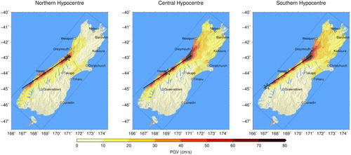
The ground motion analyses that underpin the AF8 scenario are discussed in detail in Bradley et al. (Citation2017). The effect of different hypocentre locations and rupture directivity options on predicted ground motions were considered explicitly. The three simplest scenarios place the mainshock hypocentre () near the southern or northern end of the fault source (which yield unilateral ruptures with northeast or southwest directivities), or toward the middle of the source near Haast (which yields bilateral directivity). Although the scenario using a southwestern earthquake hypocentre with northeastward directivity is generally favoured by workshop consensus as likely to cause the greatest shaking in areas of highest vulnerability, simulated ground motions have been created for each of the three options. In each case, the progression of ground motion intensity from source varies for given locations throughout the South Island (). For example, in a southern hypocentre the peak ground velocity (PGV) in Christchurch occurs 2.5 min after the mainshock initiation (Bradley et al. Citation2017).
Figure 5. Intensity models for three Alpine Fault rupture scenarios on Alpine F2 K, (left) northern hypocentre with north to south directivity; (middle) central hypocentre with bi-lateral directivity, and (right) southern hypocentre with south to north directivity.
The aftershock sequence following the mainshock event has been estimated considering Omori’s Law (Citation1894; Utsu et al. Citation1995). The AF8 model predicts two MW > 7, 20 MW > 6 and 215 MW > 5 aftershocks during the first 7 days. Aftershock activity is greatest in the first few hours and first day and diminishes through the first week. Aftershocks are mostly concentrated within 10 km of the fault rupture zone. Importantly, large aftershocks of MW > 6.5 were deliberately sited in each CDEM group to test their response capability locally (Orchiston et al. Citation2016). This included aftershocks in the Te Anau, Nelson Lakes and Molesworth areas (Orchiston et al. Citation2016).
Assessment of geomorphic hazards
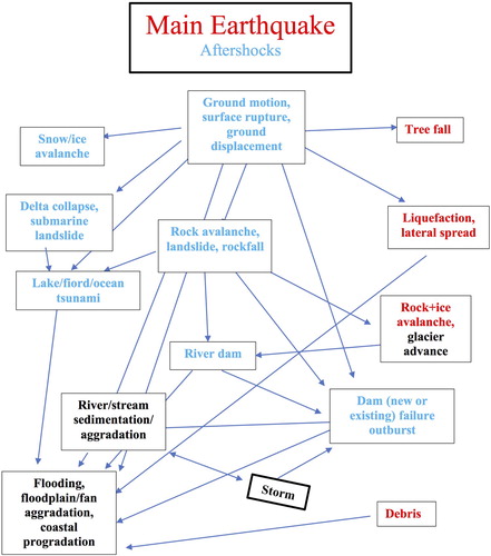
It is now well-known that the consequences of earthquakes result not only from the immediate effects of ground shaking, but also, and to a perhaps even greater extent, from the geomorphic consequences of ground shaking on the landscape (Robinson and Davies Citation2013; ). These mainly arise from mass movements (landslides, rockfalls, rock avalanches, soil slides), which themselves can be destructive; and include the cascading effects on river systems (landslide dams, flooding, dambreak floods and longer-term aggradation, debris flows), on lakes and fiords (tsunami), and in drastically altering the behaviour of rivers due to the long-term increase in sediment supply (Robinson and Davies Citation2013; Langridge et al. Citation2016a). These consequences can be exacerbated and/or prolonged by aftershocks but can themselves continue to affect river systems for decades ().
Figure 6. Range of geomorphic phenomena triggered by a major earthquake sequence, and their relationship cascade. The earthquake sequence and subsequent storms provide the drivers and are shown in the boxes with a thick black outline. The longevity of each resulting phenomenon is indicated by colour: red, short-term; blue, immediate and prolonged; and black, long-term.
Estimating the cascading hazards from a large magnitude earthquake in complex and diverse landscapes is challenging. Many factors (source earthquake, site effects, climatic conditions, etc.) influence the size, spatio-temporal location and intensity of secondary hazards, meaning any estimate is uncertain. The scenario developed here includes an appropriate estimate of the type, number and intensity of secondary hazards, and although highly uncertain, it is plausible and thus credible.
Anticipating the landscape impacts of the event cascade following a specified earthquake is difficult. Even an earthquake as well-defined (in terms of fault type, location and seismic energy release) as the Alpine Fault rupture that formed the basis of the AF8 scenario cannot be accurately characterised by the resulting ground motion across the South Island. The difficulty in deriving accurate information, however, does not limit the value of scenario-type geomorphic information as a basis for response planning, as long as this acknowledges that the next event will be different, perhaps very different, from the scenario. Thus, planning cannot be location-specific, but rather generic and formulated in terms of capability development and adaptability. The geomorphic scenario must include effects of the appropriate type, number and intensity; their locations are not crucial as long as they are geomorphically plausible.
The geomorphic scenario was based on the co-seismic landslide susceptibility model of Robinson et al. (Citation2016), developed from the methodology of Kritikos et al. (Citation2015); this shows the relative probability of co-seismic failure of any 60 m pixel as a result of the scenario Alpine Fault earthquake. From this, a landslide size distribution and locations of about a dozen large landslides were derived. These were deliberately distributed to involve all the South Island CDEM groups. Potential for forming landslide dams was also assessed; the overtopping times of these dams was estimated from the scenario 7-day weather following the earthquake. Debris flow location and magnitude during the scenario rainstorm was based on expert knowledge, informed by a catchment topography analysis (Welsh and Davies Citation2011).
Impact assessment
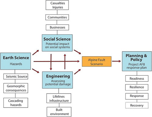
Assessing the likely impacts of a future Alpine Fault earthquake was the critical step of translating scientific knowledge into outputs that were useful and useable for CDEM professionals. If impacts could be estimated, then that can help inform development of appropriate mitigation, preparedness, response and recovery strategies. Natural hazard impact and risk assessments combine hazard, exposure and vulnerability assessments (; ) to determine the risk posed to a site, area or region from a single- or multi-hazard source. This assessment approach informs the development of mitigation strategies and effective risk management, reducing loss and increasing resilience (Papathoma-Köhle et al. Citation2011). The AF8 impact assessment scenario was developed using this conceptual approach, whereby hazard and exposure models were related by a vulnerability model to assess the likely impacts.
Figure 7. Schematic description of components and processes followed during natural hazard risk management.
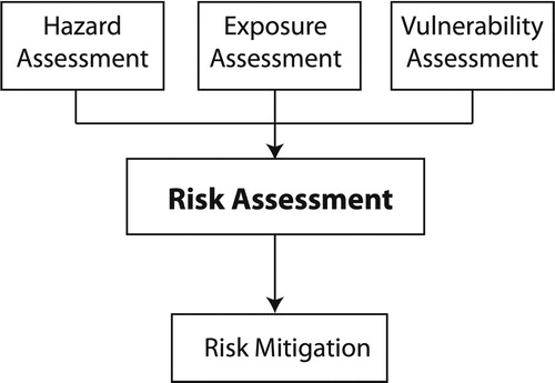
Table 2. Definitions of key terms.
Engagement with CDEM practitioners indicated that spatial distribution and relative level of damage (and level of service where appropriate) for casualties, buildings and essential services (energy, transportation, communications, water, wastewater, etc.) would be most useful impact metrics, and thus were prioritised by the science team. Through the scenario development process habitability for exposed communities emerged as an important impact metric too. Two key impact assessment studies of Alpine Fault impacts to society by Robinson et al. (Citation2014, Citation2015) provided an excellent foundation for developing the AF8 impact scenario. presents the hazard, exposure and vulnerability models used for the modelling approach.
Table 3. Hazard, exposure and vulnerability models used for the modelling approach.
A major challenge with the modelling was attempting to assess spatio-temporal impacts from the cascading hazards arising from an Alpine Fault earthquake. The ground-shaking and geomorphic scenarios were essential inputs, particularly the Robinson et al. (Citation2015) co-seismic landslide model, which could be used to inform critical infrastructure disruption (). However, application beyond critical infrastructure was difficult because vulnerability models were not available. Additionally, identifying and accessing existing exposed assets inventories (including the movement of people/tourists), given the range of agencies involved and the nature and availability of their (at times industry-sensitive) data sets, posed a substantial challenge for estimating likely casualties and habitability in a timely manner.
Because of these challenges, considerable components of the impacts scenario were developed by expert judgement (as described above), which followed a similar approach to that outlined in .
Visualisation and communication of outputs
Communication of outputs from impact modelling and expert judgement processes used both maps and tables. Maps were found to be most effective for communicating the broad spatial extent and relative intensity of impacts, particularly at regional scale, but it was useful to include tabular data for specific societal elements (e.g. casualties). We found that although visualisation of hazard intensity maps, especially dynamic, animated ground motion simulations, was very compelling and engaging, the impact assessment models were perceived to be generally more useful to emergency managers for planning purposes. Feedback indicated that these outputs were easier for individuals to visualise, because they could be more easily related to real-world experiences and so could more rapidly and accurately consider appropriate mitigation, preparedness, response and recovery strategies (Paton et al. Citation1999; GFDRR Citation2016; Becker et al. Citation2015).
The experience of the impact assessment team during this process was that the end users, including emergency managers, were unfamiliar with the types of models that could be developed, and the specificities of outputs that would be most useful. This has been identified as a future research need, and efforts are currently underway to better understand how to develop science products for use in emergency management. Progress has been made as a result of the intense stakeholder engagement and close collaboration required to generate useful response planning tools.
Response workstream
The seven planning workshops carried out in year 1 of the project brought together representatives from a wide range of organisations in each of the regional contexts within which they were held (e.g. health, lifelines, welfare, emergency services). Each workshop presented a summarised version of the Alpine Fault earthquake scenario in three stages within a day-long workshop. The workshops attracted between 30 and 120 participants, reflecting the size and complexity of the respective group areas. For example, Marlborough CDEM Group, comprises only one local authority and covers a relatively small area, whereas Canterbury comprises 10 local authorities, two district health boards, the bases for government agencies, distinctly different landforms, communities and economies, and covers an extensive geographic area. Each workshop was hosted by the local CDEM group emergency management office, with venue and hospitality costs met from the project budget. Participants were divided into functional syndicates which included, depending on local contexts: response control/local government; emergency services; social and health services, lifeline utility infrastructure providers; science/environmental impacts, and; community/rūnanga groups.
The most severely impacted regions in the scenario were the West Coast, inland Otago, Fiordland (Southland), inland and low-lying coastal parts of Canterbury, and the southern parts of Nelson, Tasman and Marlborough. Direct impacts on the environment, infrastructure, communities, individuals and economic activities were considered. Planning considerations focused initially on meeting immediate needs within each group area and extended to planning to support seriously impacted parts of other groups’ areas, and to receive and support people displaced by the impact of the quake and its consequences.
The West Coast workshop was the most detailed, due to the severe disruption that would occur throughout the region in the event of a major Alpine Fault quake. The focus was meeting local needs, evacuating those most in need and getting support to worst-affected communities. The Canterbury and Wellington workshops highlighted the regional complexities around the presence of South Island and national agency headquarters in the respective regions, the scale of the impacts within their purview, and the expectation that response support to other, more severely impacted regions will be coordinated from them. The Southland workshop was similar in its scope, due to expected impacts in distant parts of the region and the expectation that Southland would act in support of the more severely impacted Queenstown Lakes district of the Otago CDEM Group region. The initial impacts on the Nelson–Tasman and Marlborough group areas resulted in their workshops being able to focus more on preparing to receive displaced people from the more severely affected areas and acting as staging areas for resources into and out of the West Coast, while also meeting local needs.
The regional workshops concluded with a planning workshop with representatives of national-level organisations and Wellington local authorities, linking Project AF8 to quake planning in the Wellington region, including the Wellington Earthquake National Initial Response Plan (WENIRP). Functional workshops bringing together health, emergency services and defence, and public information management stakeholders from across the South Island and national agencies followed in the early stages of year 2, from July to September, to further issues and opportunities identified in the earlier regional multi-agency workshops.
Outcomes of Project AF8
Advancing the science
Project AF8 has played a significant role in driving the research agenda, particularly in targeted outputs from the Resilience Challenge Rural Laboratory (Project 2: Multi-level resilience) and latterly the QuakeCoRE Alpine Fault case study. Because of the scope of Project AF8, the risk workstream collated the best available science on the hazard-to-impact aspects of a potential Alpine Fault rupture but did not advance the science directly for the purpose of developing the first iteration of the scenario. Since then, several efforts aligned with Project AF8 have aimed to subsequently advance the science. The Alpine Fault Earthquake Case Study within QuakeCoRE (The NZ Centre of Earthquake Resilience) aims to advance Alpine Fault hazard-to-impact science and to achieve significant advances through an integrated team with deep multidisciplinary collaborations. Specifically, that project is addressing: (1) ground motion modelling for other rupture geometries of the Alpine Fault, in particular more northern ruptures involving the Wairau Fault, which pose a greater hazard to the Wellington region; (2) understanding island-wide liquefaction impacts due to lower amplitude, but longer duration ground shaking; (3) expected damage to lifeline networks, heritage buildings and the built urban environment in general; and (4) the business disruption impacts and subsequent effects of business productivity in the aftermath of the event.
The South Island Alpine Fault Earthquake Response (SAFER) plan
The SAFER plan aims to address the requirement within the CDEM Act 2002 (NZ Government Citation2016) that all CDEM groups, their member local authorities and partner agencies plan for the serious hazards and risks that they face. The seven workshops were used, in part, to inform the development of the SAFER plan. The functions, roles and responsibilities outlined within the SAFER plan will be informed by the Guide to the National CDEM Plan (MCDEM Citation2015a), with coordination arrangements consistent with the NZ Coordinated Incident Management System (CIMS) (DPMC Citation2014). The planning work itself is based on the intelligence cycle and the planning process contained in the current CIMS manual, and the Director’s Guideline for Response Planning in CDEM (MCDEM Citation2015b), whereby science outputs and emergency response management expert analysis provide the ‘intelligence’ basis for systematic, all-agencies planning for across-South Island response priorities and actions.
The SAFER plan is being developed at the time of writing, using the first 3 days of immediate life-saving response, followed by ongoing response and relief, and the transition to recovery. The plan is based on the national standard provided for in CIMS and informed by operational response planning guidelines (MCDEM Citation2015b). An outline of the contents of the plan is described in .
Table 4. Project AF8 significant areas for SAFER Plan development.
Outreach
Project AF8 acknowledged the importance of effective risk communication and public outreach by developing a communication committee. One of the communication aims is that South Island communities are aware of Project AF8 and can use the knowledge as a basis for improving individual, household and community understanding of the hazard, to help them prepare and build resilience. To improve the visibility of the project, a series of short- and long-format videos were designed and developed in late 2017. These videos are being launched on the RNZ (Radio New Zealand) web platform in 2018. They aim to provide tools for Alpine Fault science outreach, as well as snapshots of resilient, proactive behaviours by individuals, communities, businesses and agencies in building preparedness for a future Alpine Fault event (Paton and McClure Citation2013; Becker et al. Citation2018). The target audience is the general public and agencies interested in developing their own resilient practices, including staff training and community engagement by CDEM and partner agencies, as well as lifelines organisations and others. An evaluation of the videos in terms of effective communication and use as tools for engagement is currently being undertaken.
Another major initiative to build awareness and resilience and increase response capability, is a national Tier 4 Alpine Fault exercise in 2020. This will be a crucial opportunity to test the SAFER plan across the country, particularly coordinating the response that will be required by North Island CDEM groups in support of their South Island counterparts.
Conclusion
Just over 300 years have passed since the last major rupture of the Alpine Fault in AD 1717, and potential societal consequences of the next rupture continue to increase as New Zealand’s population grows beyond 4.5 million people. Project AF8 and the SAFER plan represent the first efforts to coordinate disaster response planning for a major Alpine Fault event in the South Island, as well as other large earthquake sources (e.g. Wairau Fault, Hope Fault). Project AF8 has facilitated improved collaboration across agencies and has led to an appreciation of the need for CDEM partner agencies to work across geographic boundaries during a future Alpine Fault disaster.
Project AF8 has brought emergency management practitioners together with a ‘credible, relevant and legitimate’ (Beaven et al. Citation2016) science contribution that builds an agreed foundation for collective response planning. During the planning and engagement process, compiling a credible science scenario built trust in the project. Creating the impact scenario was then critical to facilitate the communities of practice to contribute to the project, by suggesting how they would respond to relatable impacts, including road closures, power losses, fatalities, injuries and displacements. As a boundary organisation, Project AF8 has laid the foundation for these relationships, and the trust required across organisations through stakeholder co-creation, so that future major South Island earthquake responses will be better prepared.
Acknowledgements
We thank our many partner agencies, particularly the regional Civil Defence Emergency Management groups in the South Island, for their on-going support.
Disclosure statement
No potential conflict of interest was reported by the authors.
ORCID
Caroline Orchiston http://orcid.org/0000-0002-3171-2006
Additional information
Funding
Notes
1 CDEM groups are formal collectives of local authorities, emergency, health and social services, and lifeline utilities within each regional or unitary authority area, established and operated under the CDEM Act 2002.
2 Engagement in this context is based on the IAP2’s Public Participation Spectrum, where we aspire to engage with our partner agencies through collaboration and empowerment (IAP2 Citation2017).
3 Outreach is an umbrella term for activities aimed at building public awareness of science.
4 Knowledge production is the production of new knowledge and is a characteristic of integrative research (including interdisciplinary research).
References
- Aitsi-Selmi A, Egawa S, Sasaki H, Wannous C, Murray V. 2015. The sendai framework for disaster risk reduction: renewing the global commitment to people’s resilience, health and well-being. International Journal of Disaster Risk Science. 6(2):164–176. doi: 10.1007/s13753-015-0050-9
- Beaven S, Wilson T, Johnston L, Johnston D, Smith R. 2016. Role of boundary organization after a disaster: New Zealand’s natural hazards research platform and the 2010–2011 Canterbury Earthquake Sequence. Natural Hazards Review. 18(2):05016003. doi: 10.1061/(ASCE)NH.1527-6996.0000202
- Becker J, Paton D, Johnston D. 2015. Communication of Risk: A community resilience perspective, GNS Science Report 2015/66. 30 p.
- Becker JS, Leonard GS, Potter SH, Coomer MA, Paton D, Wright KC, Johnston DM. 2018. Organisational response to the 2007 Ruapehu Crater Lake dam-break lahar in New Zealand: use of communication in creating effective response. In: Fearnley CJ, Bird DK, Jolly GE, Haynes K, McGuire B, editor. Observing the volcano world: volcano crisis communication. Springer International Publishing; Advances in Volcanology. doi:10.1007/11157_2016_38.
- Berryman K, Cooper A, Norris R, Villamor P, Sutherland R, Wright T, Schermer E, Langridge R, Biasi G. 2012a. Late Holocene rupture history of the Alpine Fault in South Westland, New Zealand. Bulletin of the Seismological Society of America. 102:620–638. doi:10.1785/0120110177.
- Berryman KR, Beanland S, Cooper AF, Cutten HN, Norris RJ, Wood PR. 1992. The Alpine Fault, New Zealand: variation in Quaternary structural style and geomorphic expression. Annales Tectonicae. VI:126–163.
- Berryman KR, Cochran UA, Clark KJ, Biasi GP, Langridge RM, Villamor P. 2012b. Major earthquakes occur regularly on an isolated plate boundary fault. Science. 336(6089):1690–1693. doi: 10.1126/science.1218959
- Bradley BA, Bae SE, Polak V, Lee RL, Thomson EM, Tarbali K. 2017. Ground motion simulations of great earthquakes on the Alpine Fault: effect of hypocentre location and comparison with empirical modelling. New Zealand Journal of Geology and Geophysics. 60(3):188–198. doi: 10.1080/00288306.2017.1297313
- Clark KJ, Cochran UA, Berryman KR, Biasi GP, Langridge RM, Villamor P, Bartholemew T, Litchfield N, Pantosti D, Marco S, et al. 2013. Deriving a long paleoseismic record from a shallow-water Holocene basin next to the Alpine fault, New Zealand. The Geological Society of America Bulletin. 125(5–6):811–832. doi: 10.1130/B30693.1
- Cochran UA, Clark KJ, Howarth J, Biasi GP, Langridge R, Villamor P, Berryman KR, Vandergoes MJ. 2017. A plate boundary earthquake record from a wetland adjacent to the Alpine fault in New Zealand refines hazard estimates. Earth and Planetary Science Letters. 464:175–188. doi:10.1016/j.epsl.2017.02.026.
- Deligne NI, Fitzgerald RH, Blake DM, Davies AJ, Hayes JL, Stewart C, Wilson G, Wilson TM, Castelino R, Kennedy BM. 2017. Investigating the consequences of urban volcanism using a scenario approach I: development and application of a hypothetical eruption in the Auckland Volcanic Field, New Zealand. Journal of Volcanology and Geothermal Research. 336:192–208. doi:10.1016/j.jvolgeores.2017.02.023.
- De Pascale GP, Langridge RM. 2012. New on-fault evidence for a great earthquake in A.D. 1717, central Alpine fault, New Zealand. Geology. 40(9):791–794. doi: 10.1130/G33363.1
- Dowrick DJ, Rhoades DA. 2011. Spatial distribution of ground shaking in characteristic earthquakes on the Wellington and Alpine Faults, New Zealand, estimated from a distributed-source model. Bulletin of the New Zealand Society for Earthquake Engineering. 44(1):1–18.
- DPMC. 2014. New Zealand Coordinated Incident Management System (CIMS), April 2014, Department of the Prime Minister and Cabinet, Wellington, New Zealand.
- Fuchs S, Birkmann J, Glade T. 2012. Vulnerability assessment in natural hazard and risk analysis: current approaches and future challenges. Natural Hazards. 64:1969–1975. doi: 10.1007/s11069-012-0352-9
- Gaillard JC, Mercer J. 2013. From knowledge to action: bridging gaps in disaster risk reduction. Progress in Human Geography. 37(1):93–114. doi: 10.1177/0309132512446717
- GFDRR. 2016. The making of a riskier future: How our decisions are shaping future disaster risk (143p). Washington, D.C., U.S.A: GFDRR.
- Gregory P. 2015. Reassessing the effectiveness of All-hazards planning in emergency management. Inquiries Journal. 7(6):1–2.
- IAP2. 2017. IAP2 Spectrum Review: summary of engagement process. International Association for Public Participation (Canada). [accessed 2018 February 28]. https://www.iap2.org.au/Resources/Search-Resources.
- ICNZ (Insurance Council of New Zealand). 2017. The cost of natural disasters in New Zealand. [accessed 2017 December 12]. https://www.icnz.org.nz/media-and-resources/natural-disasters/.
- Keys H, Green P. 2008. Ruapehu lahar New Zealand 18 March 2007: lessons for hazard assessment and risk mitigation 1995–2007. Journal of Disaster Research. 3(4):284–296. doi: 10.20965/jdr.2008.p0284
- Kritikos T, Robinson T, Davies T. 2015. Regional coseismic landslide hazard assessment without historical landslide inventories: a new approach: coseismic landslide hazard assessment. Journal of Geophysical Research. 120(4):711–729.
- Langridge RM, Howarth JD, Buxton R, Ries WF. 2016a. Natural hazard assessment for the township of Franz Josef, Westland District. GNS Science consultancy report 2016/33. 61 p.
- Langridge RM, Ries WF, Litchfield NJ, Villamor P, Van Dissen RJ, Barrell DJA, Rattenbury MS, Heron DW, Haubrock S, Townsend DB, et al. 2016b. The New Zealand Active Faults database. New Zealand Journal of Geology and Geophysics. 59(1):86–96. doi:10.1080/00288306.2015.1112818.
- MCDEM. 2015a. Guide to the national civil defence emergency management plan 2015. Wellington: MCDEM. [accessed 2017 September 3]. https://www.civildefence.govt.nz/cdem-sector/cdem-framework/guide-to-the-national-civil-defence-emergency-management-plan/.
- MCDEM. 2015b. Response Planning in CDEM - Director’s Guideline for Civil Defence Emergency Management Groups [DGL 19/15], Ministry of Civil Defence & Emergency Management. [accessed 2017 September 3]. https://www.civildefence.govt.nz/about/news-and-events/news/directors-guideline-for-lifeline-utilities-and-civil-defence-emergency-management-groups/.
- MCDEM. 2017. Wellington Earthquake National Initial Response Plan. Supporting Plan [SP 02/17]. Version 1.1, May 2017. Wellington.
- Mitchell J, Brunsdon D. 2012. Emergency Response Coordination Within Earthquake Disasters. Encyclopedia of Earthquake Engineering. Springer.
- Norris RJ, Cooper AF. 2001. Late Quaternary slip rates and slip partitioning on the Alpine Fault, New Zealand. Journal of Structural Geology. 23(2):507–520. doi:10.1016/S0191-8141(00)00122-X.
- NZ Government. 2016. Civil defence emergency management Act 2002. Wellington, New Zealand.
- Omori F. 1894. On the aftershocks of earthquakes. Journal of the College of Science, Imperial University of Tokyo. 7:111–200.
- Orchiston C, Davies T, Langridge R, Wilson T, Mitchell J, Hughes M. 2016. Alpine Fault Magnitude 8 hazard scenario. Report commissioned by Project AF8, Environment Southland, Invercargill. P. 45.
- Papathoma-Köhle M, Kappes M, Keiler M, Glade T. 2011. Physical vulnerability assessment for alpine hazards: state of the art and future needs. Natural Hazards. 58(2):645–680. doi: 10.1007/s11069-010-9632-4
- Paton D, Johnston D, Houghton B, Flin R, Ronan K, Scott B. 1999. Managing natural hazard consequences: planning for information management and decision making. Journal of the American Society of Professional Emergency Planners. VI:37–48.
- Paton D, McClure J. 2013. Preparing for disaster: building household and community capacity. Charles C. Thomas Publisher Ltd., Springfield, Illinois. 245p.
- Preuss J, Godfrey J. 2006. Guidelines for Developing an Earthquake Scenario. Earthquake Engineering Research Institute, California pp 23.
- Robinson TR, Buxton R, Wilson TM, Cousins WJ, Christophersen AM. 2015. Multiple infrastructure failures and restoration estimates from an Alpine Fault earthquake: Capturing modelling information for MERIT. Commissioned by Economics of Resilient Infrastructure Research Report 2015/04. 80p. http://www.naturalhazards.org.nz/ content/ download/11452/61255/file/Robinson%20et%20al%20ERI_2015-004.pdf.
- Robinson TR, Davies TRH. 2013. Review article: potential geomorphic consequences of a future great (Mw=8.0+) Alpine Fault earthquake, South Island, New Zealand. Natural Hazards and Earth System Science. 13:2279–2299. doi:10.5194/nhess-13-2279-2013.
- Robinson T, Davies T, Wilson T, Orchiston C. 2016. Coseismic land sliding estimates for an Alpine Fault earthquake and the consequences for erosion of the Southern Alps, New Zealand. Geomorphology. 263:71–86.
- Robinson TR, Wilson TM, Davies TRH, Orchiston C, Thompson JR. 2014. Design and development of realistic exercise scenarios: a case study of the 2013 Civil Defence Exercise Te Ripahapa. GNS Science Miscellaneous Series 69. [accessed 2017 Oct 20 ]:[113p]. https://www.researchgate.net/publication/276921038_Design_and_development_of_realistic_exercise_scenarios_a_case_study_of_the_2013_Civil_Defence_Exercise_Te_Ripahapa.
- Ronan KR, Paton D, Johnston DM, Houghton BF. 2000. Managing societal uncertainty in volcanic hazards: a multidisciplinary approach. Disaster Prevention and Management: An International Journal. 9(5):339–349. doi: 10.1108/09653560010361366
- Smith K. 2013. Environmental hazards: assessing risk and reducing disaster. New York, USA: Routledge.
- Smith W, Dowell J, Ortega-Lafuente MA. 1999. Designing paper disasters: An authoring environment for developing training exercises in integrated emergency management. Cognitition, Technology and Work. 1(2):119–132. doi: 10.1007/s101110050038
- Stevenson J, Becker J, Cradock-Henry N, Johal S, Johnston D, Orchiston C, Seville E. 2017. Economic and social reconnaissance: Kaikoura earthquake 2016. Bulletin of the New Zealand Society for Earthquake Engineering. 50(2):343–351.
- Stirling MW, McVerry G, Gerstenberger M, Litchfield N, Van Dissen R, Berryman K, Barnes P, Wallace L, Villamor P, Langridge R, et al. 2012. National seismic hazard model for New Zealand: 2010 update. Bulletin of the Seismological Society of America. 102(4):1514–1542. doi: 10.1785/0120110170.
- Stirling MW, Wesnousky SG, Berryman K. 1998. Probabilistic seismic hazard analysis of New Zealand. New Zealand Journal of Geology and Geophysics. 41(4):355–375. doi: 10.1080/00288306.1998.9514816
- Sutherland R, Eberhard-Phillips D, Harris RA, Stern T, Beavan J, Ellis S, Henrys S, Cox S, Norris R, Townend J, et al. 2007. Do great earthquakes occur on the Alpine Fault in central South Island, New Zealand? Geophysical Monograph. 175:235–251.
- UNISDR (United Nations International Strategy for Disaster Risk Reduction). 2009. Terminology. [accessed 2018 January 26] https://www.unisdr.org/we/inform/terminology.
- UNISDR (United Nations International Strategy for Disaster Risk Reduction). 2015a. Sendai framework for disaster risk reduction 2015–2030. Geneva: UNISDR.
- UNISDR (United Nations International Strategy for Disaster Risk Reduction). 2015b. Global assessment report on disaster risk reduction 2015. [accessed 2018 January 25]. https://www.unisdr.org/we/inform/publications/42809.
- Utsu T, Ogata Y, Matsura RS. 1995. The centenary of the Omori Formula for a Decay Law of aftershock activity. Journal of Physics of the Earth. 43:1–33. doi: 10.4294/jpe1952.43.1
- Weichselgartner J, Pigeon P. 2015. The role of knowledge in disaster risk reduction. International Journal of Disaster Risk Science. 6:107–116. doi: 10.1007/s13753-015-0052-7
- Welsh A, Davies T. 2011. Identification of alluvial fans susceptible to debris-flow hazards. Landslides. 8(2):183–194. doi: 10.1007/s10346-010-0238-4
- Wilson G, Wilson TM, Delinge NI, Cole JW. 2014. Volcanic hazard impacts to critical infrastructure: A review. Journal of Volcanology and Geothermal Research. 286:148–182. doi:10.1016/j.jvolgeores.2014.08.030.
- Wotherspoon LM, Palermo A, Holden C. 2017. The 2016 Mw7.8 Kaikoura Earthquake: an introduction. Bulletin of the New Zealand Society for Earthquake Engineering. 50(2). http://www.nzsee.org.nz/db/Bulletin/Archive/50(2)000i.pdf