
ABSTRACT
The Alpine Fault is very well delineated by recent high-resolution aeromagnetic data sets over much of its length in New Zealand’s South Island. Aeromagnetic data acquired over parts of the West Coast, Tasman and Marlborough regions for the New Zealand Government reveal different types of total magnetic intensity anomalies associated with the fault that can be characterised as truncated, step, ridge, trough and broad anomalies. Fault-terminated Permian ultramafic rocks, Late Cretaceous basalt and some Early Cretaceous intrusions are attributed to the more prominent truncated anomalies. The pre-eminent step anomaly is associated with relatively magnetic Alpine Schist juxtaposed against variable but generally less magnetic Western Province rocks. Strongly positive ridge anomalies occurring in the Alpine Fault zone are associated with Mesozoic mafic metavolcanic and ultramafic rocks. A trough anomaly associated with the Alpine Fault occurs in the southernmost survey and may reflect some hydrothermal demagnetisation. Broad, low-amplitude anomalies underlying the hanging wall are attributed in one instance to the extension of the magnetic Hohonu Range granitoids and dikes extending southeast in the footwall and in other places as magnetic schist rocks in the hanging wall. The apparent great-circle displacement of the Alpine Fault based on offset of magnetic anomalies associated with the Dun Mountain Ultramafics Group rocks is c. 461 km, in close agreement with the more precise 459 km inferred from geological map offset.
Introduction
New Zealand’s Alpine Fault is the dominant surface expression of the Australia–Pacific plate boundary in the South Island (). The Alpine Fault has had a profound influence on understanding South Island geology since it was first recognised by Wellman and Willett (Citation1942). An apparent dextral displacement of 480 km was deduced by Wellman in 1949 (quoted in Benson Citation1952) and has resulted in the juxtaposition of contrasting geological basement terranes, best exemplified by distinctive ultramafic igneous rocks of the Early Permian ophiolitic Dun Mountain Ultramafics Group (; ) displaced from the Red Hills south of Nelson (Rattenbury et al. Citation1998, Citation2006) to the Olivine Range of South Westland (Rattenbury et al. Citation2010; Edbrooke et al. Citation2014). Based on sedimentary basin records, fault displacement commenced in the Late Oligocene (King Citation2000) and continues apace in recent times (Norris and Cooper Citation2001). The slip rate, between 15 and 25 m/ka through the Late Quaternary (Norris and Cooper Citation2001; Sutherland et al. Citation2006), is strongly expressed in the topography and geology, the latter through the erosion and accumulation of poorly consolidated sediment adjacent and across the fault trace and through the disruption of these and older rocks by presently active and now inactive fault strands.
Figure 1. A, High-resolution aeromagnetic survey areas traversed by the Alpine Fault (black line) showing total magnetic intensity, upward continued to 400 m (acquired for the New Zealand Government, Vidanovich Citation2013; Thomson Aviation Citation2016). B, Geological basement terranes, intrusive rocks and covering strata adjacent to the Alpine Fault (black line) in the West Coast, Nelson and Marlborough regions (adapted from Edbrooke et al. Citation2014) with hatched overlay of schist (textural zone III–IV after Heron Citation2014).
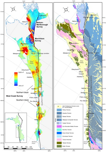
Table 1. Stratigraphic framework for the western and northern South Island (after Mortimer et al. Citation2014) including significant very weakly magnetic, consistently magnetic (bold) and variably magnetic (italics) lower-level stratigraphic units displaced or deformed by the Alpine Fault.
Airborne geophysical surveys are important data sets for understanding the geology of mineral provinces, particularly where outcrop is obscured by surficial sediments or thick vegetation. Surveys are typically undertaken in areas with economic mineralisation potential and their principal use is to better identify geology through defining the extent of different rock units or delineating structural features. Faults are typically expressed by truncation or stepping of magnetic anomalies but in some cases the fault zone itself may have magnetic expression through incorporation of magnetic material, for example, in a mylonite zone. Reduction in magnetic intensity could be caused by hydrothermal destruction of magnetic minerals. For New Zealand’s Alpine Fault, examples of these expressions are all apparent.
Aeromagnetic surveys involve a fixed-wing aeroplane or helicopter carrying a magnetometer flying parallel lines, typically tens of kilometres long and separated by 100–400 m, to cover an area of tens to thousands of square kilometres. Accurate GPS-controlled positioning is essential, as is height measurement where a constant height above ground, typically 35–100 m, is sought for draped surveys (Isles and Rankin Citation2013). The magnetometer records variations in the Earth’s magnetic field intensity; these are influenced by varying concentrations of different magnetic minerals in rocks or sediments at and below the ground surface. High to very high magnetic susceptibility rocks typically contain magnetite or titanomagnetite and are commonly igneous. Other magnetic minerals such as pyrrhotite, hematite or ilmenite have lower magnetic susceptibility but in sufficient concentrations will result in magnetic anomalies. Some sedimentary units contain detrital magnetic minerals and can have moderate to high magnetic susceptibilities. Metamorphism of some sedimentary or igneous rocks can result in the growth of magnetic minerals. The further the sensor is from the magnetic source the weaker and broader the recorded signal, but aeromagnetic surveys can record the signal of strongly magnetic rock units that occur many kilometres below the surface.
Aeromagnetic data sets
In 2011, the government agency New Zealand Petroleum & Minerals (NZP&M), responsible for managing and promoting the Crown’s mineral estate, commissioned an airborne magnetic and radiometric survey of the West Coast of the South Island (Vidanovich Citation2013). The West Coast Airborne Geophysical Survey () was acquired between February 2011 and March 2013 in a northern block, the southwestern part of which covers the Alpine Fault between Springs Junction and Whataroa, and in a southern block extending from Fox Glacier to Awarua Point. The survey was flown along a 110–290 bearing at a 200 m line spacing and a target 50 m ground clearance. Orthogonal tie lines were flown every 2 km.
Data files in ASEG-GDF2 ascii format and processed, levelled grids in ERMapper format and GeoTIFF formats at 40 m cell resolution were supplied to NZP&M and available for download from their mineral exploration database (Vidanovich Citation2013). The aeromagnetic grids included many different industry standard variants including total magnetic intensity (TMI), and TMI reduced to pole (RTP). The RTP processing compensates for the anomaly to source displacement effect caused by the local magnetic field inclination and involves subtracting the International Geomagnetic Reference Field calculated at mid points in the two survey blocks. This effectively removes dipole effects relating to induced magnetisation (Isles and Rankin Citation2013). Dipole-like anomalies persisting after RTP processing may reflect remanent magnetisation in some rock bodies.
In 2016, NZP&M commissioned another airborne magnetic and radiometric survey of Buller, east Nelson and northern Marlborough (Thomson Aviation Citation2016) at similar specifications (110–290 bearing, 200 m line spacing, 35 m ground clearance) to the West Coast survey to which it abuts in the Victoria Range–Springs Junction area. These Murchison and Nelson–Marlborough surveys ( and ) cover the Alpine Fault from northeast of Springs Junction to the middle reaches of the Wairau valley and around Blenheim where it covers the eastern on-land extent of the Wairau segment of the Alpine Fault.
The purpose of this article is to describe the magnetic anomalies associated with the Alpine Fault and provide geological interpretation of them in terms of their source lithology and/or structural significance. We build on wider preliminary interpretation (Rattenbury Citation2014, Citation2015) of the West Coast survey that included Alpine Fault-related features and integrates the two newer aeromagnetic surveys of the Murchison and Nelson–Marlborough areas (Rattenbury Citation2017). Forward modelling and magnetic inversion modelling are beyond the scope of this paper but have the potential to help constrain the form and dip of the Alpine Fault and constrain footwall rock types.
Regional geology
The geology of the area adjacent to the Alpine Fault has most recently been mapped by eight 1:250 000 Geological Map of New Zealand series maps; Nelson (Rattenbury et al. Citation1998), Wakatipu (Turnbull Citation2000), Wellington (Begg and Johnston Citation2000), Greymouth (Nathan et al. Citation2002), Kaikoura (Rattenbury et al. Citation2006), Aoraki (Cox and Barrell Citation2007), Fiordland (Turnbull et al. Citation2010) and Haast (Rattenbury et al. Citation2010). These geological maps have been integrated into a single, national, digital, seamless, geological map data set (Heron Citation2014) and an overarching stratigraphic framework developed (, after Mortimer et al. Citation2014).
The West Coast has a Cambrian to Early Cretaceous Austral Superprovince crustal basement comprised of metasedimentary, metamorphic and igneous rocks (, Mortimer et al. Citation2014). The area northwest of the Alpine Fault is dominated by the metasedimentary Buller Terrane comprised of the Greenland Group and similar Ordovician siliciclastic units near Springs Junction (), and the Devonian–Carboniferous and Early Cretaceous granitic rocks that intrude the terrane (Rattenbury et al. Citation1998, Citation2006, Citation2010; Nathan et al. Citation2002; Cox and Barrell Citation2007). The intrusions are divided into petrogenetic suites; notably the Late Devonian–Early Carboniferous Karamea Suite, the Early Cretaceous Rahu Suite and Separation Point Suite, and several others of relatively limited extent (Tulloch Citation1988). Faulted slivers of the Cambrian–Devonian Takaka Terrane occur around Springs Junction (Nathan et al. Citation2002; Rattenbury et al. Citation2006). These comprise mafic and intermediate volcanic and volcaniclastic map units as well as siliciclastic and carbonate metasedimentary rocks. Rock magnetic susceptibilities vary widely between and within these terranes, groups and igneous suites (Tulloch Citation1989; Rattenbury Citation2014). The widespread Greenland Group and Karamea Suite generally have very low magnetic susceptibilities. The Rahu, Separation Point and Darran suite intrusions are generally high magnetic susceptibility (Tulloch Citation1989) as are the Dun Mountain Ultramafics and Livingstone Volcanics groups (Petlab geoanalytical database http://pet.gns.cri.nz; Strong et al. Citation2016).
The rocks southeast of the Alpine Fault are dominated by the Alpine Schist of the Rakaia Terrane () metamorphosed to amphibolite facies (McClintock and Cooper Citation2003; Cox and Barrell Citation2007; Rattenbury et al. Citation2010). The metamorphic grade progressively decreases to the southeast into prehnite–pumpellyite facies, quartzofeldspathic greywacke rocks. Prominent within the Alpine Schist are numerous thin greenschist bands that are metamorphosed mafic igneous layers. Greenschist within the Otago Schist typically has magnetic susceptibility 10–100 times greater than the surrounding greyschist (Martin et al. Citation2016). In the western Olivine Range in South Westland are Permian–Triassic Caples Terrane schist and semischist, and the variably serpentinised peridotite rocks of the Permian Dun Mountain Ultramafic Group (Rattenbury et al. Citation2010). Their offset equivalents occur north and northwest of the Alpine Fault in Tasman and northern Marlborough through the Red Hills and Dun Mountain (Rattenbury et al. Citation1998, Citation2006). The Caples Terrane rocks typically have low magnetic susceptibilities and the Dun Mountain Ultramafics Group rocks have very high susceptibilities (Petlab geoanalytical database http://pet.gns.cri.nz). The Livingstone Volcanics Group rocks occurring west of the ultramafic rocks also have high magnetic susceptibilities. To the west of the mafic and ultramafic volcanic rocks in both regions are Permo-Triassic Maitai Group sedimentary rock and Brook Street Volcanics Group volcanogenic sedimentary rock. South of Nelson are thin slivers of Triassic Richmond Group volcaniclastic rocks of the Murihiku Terrane and mafic to felsic intrusions of the Median Batholith. These rocks have typically lower magnetic susceptibility although have some variability susceptibilities (Petlab geoanalytical database http://pet.gns.cri.nz).
The Late Cretaceous–Pliocene Zealandia Megasequence cover rocks, comprising the Momotu, Haerenga, Waka and Maui supergroup rocks (; ; Mortimer et al. Citation2014) are predominantly sedimentary. Rare igneous rocks include a Late Cretaceous granodiorite intrusion near Whataroa (Cox and Barrell Citation2007). Late Cretaceous Arnott Basalt occurs in South Westland on the coast between Haast and Fox Glacier (; Sewell et al. Citation1988; Rattenbury et al. Citation2010), and there are other isolated basalt occurrences in central and northern West Coast (Nathan et al. Citation2002). The igneous rocks typically have high magnetic susceptibilities (Rattenbury Citation2015).
Late Pliocene and Quaternary sediments of the Pakihi Supergroup (Mortimer et al. Citation2014) are widespread, particularly in flat, low-lying areas and are typically associated with modern drainage systems. Most West Coast Quaternary sediments are fluvial in origin, forming alluvial deposits defined by river terraces, or colluvial/alluvial fans that emerge and spread onto valley floors. Some areas have considerable till deposits, commonly recognisable as lateral and terminal moraines.
The region has undergone significant periods of deformation and tectonic development since the early Paleozoic accompanied by major periods of erosion and reworking of sedimentary material. Magmatic activity was particularly vigorous in the mid Paleozoic and Mesozoic. Rapid and sustained uplift of the Southern Alps since the Pliocene has resulted in an elevated thermal regime adjacent to the Alpine Fault. Extreme geothermal gradients have been inferred from measured water temperatures from deep drilling adjacent to the fault in the Whataroa valley (D; Sutherland et al. Citation2017). Warm springs in valley floors at and up to 10 km southeast of the fault are present-day manifestations of the elevated geothermal gradient, and fossil hydrothermal systems are inferred from metalliferous veins and alteration systems (Johnstone et al. Citation1990; Craw and Campbell Citation2004).
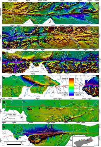
Figure 2. Aeromagnetic context of the West Coast part of the Alpine Fault from southwest (inset A) to northeast (inset F). The images from the West Coast Geophysical Survey show total magnetic intensity residual anomalies, reduced to pole, blended with a northwest illumination. Note, same colour scale applies to different anomaly ranges for each survey block. Labelled features are described in . Alpine Fault trace (red) extracted from Heron (Citation2014), warm springs (unfilled pink crosses) from Heron (Citation2014) and Land Information New Zealand.
Magnetic anomalies
The supplied levelled and 40 m gridded TMI data show widely varying magnetic intensity and anomaly types for all three surveys (; and ). To first order, the most prominent features apparent from the surveys are strong, longer wavelength positive anomalies around Nelson, Rotoroa, Inangahua, Kumara, Hohonu Range, and the western Olivine Range. Shorter wavelength, high-amplitude linear anomalies are a feature of the Victoria Range and west of Fox Glacier. Multiple parallel, linear anomalies occur in the central Southern Alps. The most intense positive anomalies occur in the Southern Alps south of Hokitika. Large areas of subdued magnetic intensity, that is, residual magnetic anomalies around 0 nT, occur over large parts of Marlborough, around Murchison, Grey Valley, Hokitika to Harihari and much of coastal South Westland. These features are discussed in more detail by Rattenbury (Citation2015).
The aeromagnetic intensity in the steep valley country of the Southern Alps, the Hohonu, Victoria and other ranges ( and ) varies to some extent with topography such that TMI lows are associated with topographic lows (Rattenbury Citation2015). Variation from the survey terrain clearance specification of 50 m contributes to this but the topographic effects are most apparent where the sensor was flown lower than surrounding ridges of magnetic rock, typical of draped surveys over rugged topography (Grauch and Campbell Citation1984; Isles and Rankin Citation2013).
This study is focused on describing aeromagnetic anomalies proximal to the Alpine Fault in terms of amplitude and/or frequency, and interpreting them in a geological context. For description purposes the anomalies have been divided into five types based on scale and aspect ratio (linearity) in relation to their faulted portion. These are truncated anomalies, step anomalies, ridge anomalies, trough anomalies and broad anomalies.
Truncated anomalies
Truncated anomalies have a relatively short faulted termination dimension compared with their overall length. Examples of Western Province truncation anomalies at the Alpine Fault trace are clearest in northern Westland and Nelson. These anomalies are attributed to a magnetic rock unit such as a pluton cut and displaced by the Alpine Fault (: G6, H1). The peridotite rocks of the Dun Mountain Ultramafic Group are the most spectacular truncations apparent from the surveys (: A2, : H4). Their prominent magnetic expression diminishes close to the fault and possibly reflects demagnetisation related to hydrothermal destruction induced by fluid circulation driven by fault movement. The sigmoidal form of anomalies at the fault trace east of Tophouse (: H3) is consistent with dextral strike-slip fault movement. Displacement of the magnetic anomaly associated with these ultramafic rocks in South Westland by the Alpine Fault to their continuation in Nelson is c. 461 km (great circle distance) and in close agreement with the apparent offset of c. 459 km derived from mapped geology (based on Heron Citation2014). The obliquity of the piercing point in South Westland, coupled with the ambiguity of marking a boundary within a magnetic gradient, suggests the mapped geology estimate is more precise. Both of these measurements are significantly lower than the oft-quoted apparent dextral displacement of 480 km deduced by Wellman in 1949 (quoted in Benson Citation1952). True offset is likely to be significantly less based on the presumption that considerable shortening (on a southeast-dipping reverse fault) has occurred across the plate boundary.
Figure 3. Aeromagnetic context of the Buller–Nelson–Marlborough part of the Alpine/Wairau Fault from southwest (inset G) to northeast (inset I). The images from the Murchison and Nelson–Marlborough Geophysical Surveys show total magnetic intensity residual anomalies, reduced to pole, blended with a northwest illumination. Note, same colour scale applies to different anomaly ranges for each survey. Labelled features are described in . Alpine/Wairau Fault trace (red) extracted from Heron (Citation2014).
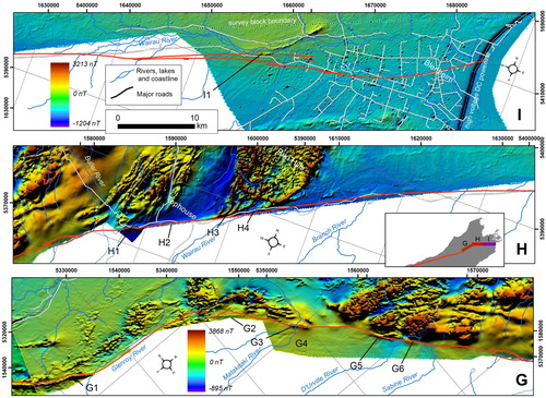
Table 2. Magnetic anomaly descriptions and their geological interpretation for the southern and central Alpine Fault. Features are labelled in .
Table 3. Magnetic anomaly descriptions and their geological interpretation for the northern Alpine Fault. Features are labelled in .
One high-amplitude linear anomaly attributed to Late Cretaceous Arnott Basalt (Sewell et al. Citation1988; Rattenbury Citation2015) is truncated at the Alpine Fault trace near Fox Glacier (: C2). Around Springs Junction linear anomalies reflecting Early Cretaceous plutons and/or volcanogenic Cambrian Takaka Terrane units are similarly terminated at the fault trace (: F3, F4). In the Wairau valley, a high-frequency, moderate amplitude curvilinear anomaly appears to have been truncated near the inferred position of the Wairau segment of the Alpine Fault concealed by Holocene river gravels (: I1).
Step anomalies
Step anomalies are apparent through juxtaposition of wide areas of contrasting intensity amplitude and/or frequency, distinguished from truncated anomalies by their comparatively long length of juxtaposition. The higher grade Alpine Schist metamorphic rocks of the Southern Alps exhibit higher magnetic intensity than the rocks northwest of the Alpine Fault and this is reflected in the > 120 km long step anomaly in central Westland ( and : D1). In detail, there is magnetic anomaly complexity associated with the Alpine Fault position (). The stepping is jagged in places and is attributed to magnetic rock layers following various thrust and strike-slip segments of the Alpine Fault trace identified by Norris and Cooper (Citation1995). The aeromagnetic data have the potential to augment fault traces inferred from detailed LiDAR terrain analysis (Barth et al. Citation2012)
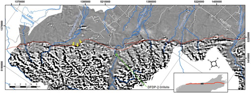
Figure 4. Aeromagnetic image (first vertical derivative of total magnetic intensity) of the Whataroa area highlighting the complex geometry of magnetic anomalies along the position of the Alpine Fault, significantly more complex than the 1:250 000 mapped trace (red, from Heron Citation2014). The complexity aligns more closely with Alpine Fault-related traces inferred from LiDAR interpretation (Barth et al. Citation2012). Anomalies at Gaunt Creek (yellow arrows) suggest magnetic variation follows the structural contour geometry of the Alpine Fault trace.
Ridge anomalies
Ridge anomalies are apparent where the fault zone has a discrete linear spike of magnetic intensity over some part of its length. Anomaly ridges near the Alpine Fault are attributed to entrainment of thin magnetic mafic and/or ultramafic igneous rock (McClintock and Cooper Citation2003; Toy et al. Citation2015) such as amphibolite/greenschist bands or dikes that have been ductily rotated and transposed into the mylonite zone from ongoing high strain (: B1, F2. F6; : G1, G5, H3). The Alpine Fault Zone has incorporated some footwall Western Province rocks (Reed Citation1964; Toy et al. Citation2015) that may have originated from mylonitised Fraser Complex gneisses and granitoids (Rattenbury Citation1991). Fraser Complex rocks coincide with strong magnetic anomalies northwest of the Alpine Fault (D, E).
Southeast of the Alpine Fault mylonite zone in South Westland, prominent linear anomalies oblique to the Alpine Fault trend (: B1) are also attributed to greenschist bands (Rattenbury et al. Citation2010; Rattenbury Citation2015). These anomalies bend towards parallelism closer to the fault, and this curvature is attributed to increasing fault-related strain.
Trough anomalies
Trough anomalies along fault traces may relate to demagnetisation in the fault zone, for example, through the hydrothermal destruction of magnetite relative to the surrounding rock. Known presently active warm springs ( and ) are not always associated with magnetic lows, however, and some of the associated lows may be due more to topographic effects. One prominent trough anomaly occurs in the Duncan River–Cascade River area in the southernmost part of the survey (: A1), adjacent to known warm spring activity (Aitchison Citation1985). The broad anomaly trough mostly immediately northwest of the Alpine Fault trace (: D2, E1) is attributed in part to a topographic effect of the elevated magnetic Alpine Schist rocks against low-lying, less-magnetic Western Province rocks and possibly to remanence associated with the schist.
Broad anomalies
There are conspicuous broad, lower amplitude anomalies in several places at and southeast of the Alpine Fault. These are attributed to relatively deep sources that may occur in the footwall or hanging wall to the fault plane. In central Westland, total magnetic intensity is distinctly elevated above background levels (: E5, F1). Northwest of the fault, strong positive anomalies are attributed to magnetic igneous rocks of the Hohonu Range, principally tonalite, granodiorite and granite intruded by dolerite and lamprophyre dikes (Rattenbury Citation2015). The anomaly persists for several kilometres southeast of the Alpine Fault, albeit more subdued in intensity and frequency. This could reflect magnetic igneous rock of the Western Province in the footwall under the southeast-dipping Alpine Fault plane, although magnetic schist in the hanging wall may also contribute.
A broad negative magnetic anomaly occurs southeast of the Alpine Fault south of Springs Junction (: F5). The source of the anomaly is not explained by known geology and although a data collection or processing artefact cannot be ruled out, the anomaly could, for example, reflect greenschist and/or ultramafic rocks in Aspiring Lithologic Association exhibiting magnetic remanence in the hanging wall or a subsurface reversely magnetised intrusion in the Alpine Fault footwall.
Between Haast and Paringa (: B2), a low-amplitude, low-frequency positive anomaly occurs southeast of the linear anomaly attributed to ultramafic rocks in the Alpine Fault mylonite zone and thus may be the down-dip extension of these rocks within the fault zone.
Conclusions
The Alpine Fault is very well delineated by aeromagnetic anomalies over much of its length. Expression of the fault is manifest through different ways and at different scales. Truncation anomalies, that is, where linear bands of strongly magnetic rock terminate at the fault and are juxtaposed against rocks with contrasting magnetic character, are widespread. Truncation anomalies are apparent for terrane units, for example, the Dun Mountain – Maitai Terrane near Nelson, and for discrete geological units such as magnetic plutons faulted against weakly magnetic schist around Springs Junction or the Arnott Basalt against schist at Fox Glacier. Step anomalies, which are also caused by juxtaposed rocks of contrasting magnetic character but with a regional extent, are evident, notably the schists of central Southern Alps faulted against the generally weakly magnetic rocks of the Western Province.
In places, the Alpine Fault is defined by magnetic ridge anomalies parallel to and within the fault zone, attributed to attenuated magnetic rock layers such as ultramafic or mafic metavolcanic rock in the mylonite zone in South Westland and Tasman. Some parts of the fault are defined by a drop in magnetic intensity, trough anomalies, caused by local hydrothermal destruction of magnetic minerals, for example, in the Cascade River area in South Westland. Known warm springs in the Southern Alps are not always associated with lower magnetic anomalies and many that are may be due more to topographic effects. In the few places where the Alpine Fault has no surface expression, such as in the lower Wairau valley, magnetic anomalies can help constrain its location if the right rock types are present.
Diffuse broad anomalies adjacent or underlying the Alpine Fault reflect deeper seated, regional variation in magnetic susceptibility. The strong anomalies associated with the Hohonu Range and many other foothills are caused by magnetic granitoids and dikes. The batholith is interpreted to persist at depth to the southeast beneath the dipping Alpine Fault plane and contribute to the regional positive magnetic anomaly there.
Acknowledgements
This article developed from Strategic Science Investment Fund research provided to GNS Science by the Government of New Zealand. The initiative of New Zealand Petroleum & Minerals to commission acquisition of these aeromagnetic data sets is gratefully acknowledged. Two anonymous reviewers and Associate Editor Jarg Pettinga have provided comments and suggestions that have substantially improved this article.
Disclosure statement
No potential conflict of interest was reported by the authors.
References
- Aitchison JC. 1985. Hot springs along the Alpine Fault, cascade river valley, south Westland, New Zealand. New Zealand Journal of Geology and Geophysics. 28:755–756. doi: 10.1080/00288306.1985.10422546
- Barth NC, Toy VG, Langridge RM, Norris RJ. 2012. Scale dependence of oblique plate-boundary partitioning: New insights from LiDAR, central Alpine fault, New Zealand. Lithosphere. 4:435–448. doi: 10.1130/L201.1
- Begg JG, Johnston MR (compilers). 2000. Geology of the Wellington area: scale 1:250,000. Lower Hutt: Institute of Geological & Nuclear Sciences. Institute of Geological & Nuclear Sciences 1:250,000 geological map 10. 64 p. + 1 folded map.
- Benson WN. 1952. Meeting of the geological division of the pacific science congress in New Zealand, February, 1949. International Proceedings of the Geological Society of America. 11:11–13.
- Cox SC, Barrell DJA (compilers). 2007. Geology of the aoraki area: scale 1:250,000. Lower Hutt: GNS Science. Institute of Geological & Nuclear Sciences 1:250,000 geological map 15. 71 p. + 1 folded map.
- Craw D, Campbell JR. 2004. Tectonic and structural setting for active mesothermal gold vein systems, Southern Alps, New Zealand. Journal of Structural Geology. 26:995–1005. doi: 10.1016/j.jsg.2003.11.012
- Edbrooke SW, Heron DW, Forsyth PJ, Jongens R. 2014. Geological map of New Zealand 1:1,000,000. GNS science geological map 2. Lower Hutt (NZ): GNS Science.
- Grauch VJS, Campbell DL. 1984. Does draping aeromagnetic data reduce terrain-induced effects? Geophysics. 49:75–80. doi: 10.1190/1.1441563
- Heron DW (compiler). 2014. Geological map of New Zealand 1:250,000. GNS science geological map 1. Lower Hutt (NZ): GNS Science.
- Isles DJ, Rankin LR. 2013. Geological interpretation of aeromagnetic data. Australian Society of Exploration Geophysicists. doi:10.1190/1.9781560803218.
- Johnstone RD, Craw D, Rattenbury MS. 1990. Southern Alps Cu-Au hydrothermal system, Westland, New Zealand. Mineralium Deposita. 25:118–125. doi: 10.1007/BF00208854
- King PR. 2000. Tectonic reconstructions of New Zealand: 40 Ma to the present. New Zealand Journal of Geology and Geophysics. 43:611–638. doi: 10.1080/00288306.2000.9514913
- Martin AP, Cox SC, Smith Lyttle B. 2016. Geology of the middlemarch area 1:50 000: digital vector data 2016. GNS science geological map 5. Lower Hutt (NZ): GNS Science.
- McClintock MK, Cooper AF. 2003. Geochemistry, mineralogy, and metamorphic history of kyanite-orthoamphibole-bearing Alpine Fault mylonite, South Westland, New Zealand. New Zealand Journal of Geology and Geophysics. 46:47–62. doi: 10.1080/00288306.2003.9514995
- Mortimer N, Rattenbury MS, King PR, Bland KJ, Barrell DJA, Bache F, Begg JG, Campbell HJ, Cox SC, Crampton JS, et al. 2014. High-level stratigraphic scheme for New Zealand rocks. New Zealand Journal of Geology and Geophysics. 57:402–419. doi: 10.1080/00288306.2014.946062
- Nathan S, Rattenbury MS, Suggate RP (compilers). 2002. Geology of the greymouth area: scale 1:250,000. Lower Hutt: Institute of Geological & Nuclear Sciences. Institute of Geological & Nuclear Sciences 1:250,000 geological map 12. 58 p. + 1 folded map.
- Norris RJ, Cooper AF. 1995. Origin of small-scale segmentation and transpressional thrusting along the Alpine Fault, New Zealand. Geological Society of America Bulletin. 107:231–240. doi: 10.1130/0016-7606(1995)107<0231:OOSSSA>2.3.CO;2
- Norris RJ, Cooper AF. 2001. Late Quaternary slip rates and slip partitioning on the Alpine Fault, New Zealand. Journal of Structural Geology. 23:507–520. doi: 10.1016/S0191-8141(00)00122-X
- Rattenbury MS. 1991. The Fraser complex: high-grade metamorphic, igneous and mylonitic rocks in central Westland, New Zealand. New Zealand Journal of Geology and Geophysics. 34:23–33. doi: 10.1080/00288306.1991.9514436
- Rattenbury MS. 2014. Geological interpretation of west coast aeromagnetic data. Proceedings of the 47th annual conference, New Zealand branch of the Australasian institute of mining and metallurgy. 24–27 August 2014; Hamilton.
- Rattenbury MS. 2015. Preliminary geological interpretation of airborne geophysical datasets, West Coast, New Zealand. GNS Science report 2014/71. GNS Science, Lower Hutt. 56 p.
- Rattenbury MS. 2017. Geology revealed from the new aeromagnetic surveys of northern South Island, New Zealand. Proceedings of the 50th annual conference, New Zealand branch of the australasian institute of mining and metallurgy. 10–13 September 2017; Christchurch.
- Rattenbury MS, Cooper RA, Johnston MR (compilers). 1998. Geology of the Nelson area: scale 1:250,000. Lower Hutt: Institute of Geological & Nuclear Sciences Limited. Institute of Geological & Nuclear Sciences 1:250,000 geological map 9. 67 p. + 1 folded map.
- Rattenbury MS, Jongens R, Cox SC (compilers). 2010. Geology of the haast area: scale 1:250,000. Lower Hutt: Institute of Geological & Nuclear Sciences Limited. Institute of Geological & Nuclear Sciences 1:250,000 geological map 14. 67 p. + 1 folded map.
- Rattenbury MS, Townsend D, Johnston MR (compilers). 2006. Geology of the kaikoura area: scale 1:250,000 geological map. Lower Hutt: GNS Science. Institute of Geological & Nuclear Sciences 1:250,000 geological map 13. 70 p. + 1 folded map.
- Reed JJ. 1964. Mylonites, cataclasites, and associated rocks along the Alpine Fault, South Island, New Zealand. New Zealand Journal of Geology and Geophysics. 7:645–684. doi: 10.1080/00288306.1964.10428124
- Sewell R, Nathan S, Adams CJ. 1988. Geochemistry of late Cretaceous basaltic rocks from north Westland. In: Research notes 1988. New Zealand geological survey record 35. Lower Hutt: New Zealand Geological Survey; p. 113–116.
- Strong DT, Turnbull RE, Haubrock SN, Mortimer N. 2016. Petlab: New Zealand’s national rock catalogue and geoanalytical database. New Zealand Journal of Geology and Geophysics. 59:475–481. doi: 10.1080/00288306.2016.1157086
- Sutherland R, Berryman KR, Norris RJ. 2006. Quaternary slip rate and geomorphology of the Alpine Fault: implications for kinematics and seismic hazard in southwest New Zealand. Geological Society of America Bulletin. 118:464–474. doi: 10.1130/B25627.1
- Sutherland R, Townend J, Toy VG, Upton P, Coussens J, DFDP-2 Science Team. 2017. Extreme hydrothermal conditions at an active plate-bounding fault. Nature. 546 (7656):137–140. doi:10.1038/nature22355.
- Thomson Aviation. 2016. South Island regional aeromagnetic survey project 2015–2017. Unpublished mineral report MR5400. Wellington (New Zealand): NZP&M, Ministry of Business, Innovation & Employment. https://www.nzpam.govt.nz/maps-geoscience/exploration-database/
- Toy VG, Boulton CJ, Sutherland R, Townend J, Norris RJ, Little TA, Prior DJ, Mariani E, Faulkner D, Menzies CD, et al. 2015. Fault rock lithologies and architecture of the central Alpine fault, New Zealand, revealed by DFDP-1 drilling. Lithosphere. 7:155–173. doi: 10.1130/L395.1
- Tulloch AJ. 1988. Batholiths, plutons, and suites: nomenclature for granitoid rocks of Westland—Nelson, New Zealand. New Zealand Journal of Geology and Geophysics. 31:505–509. doi: 10.1080/00288306.1988.10422147
- Tulloch AJ. 1989. Magnetic susceptibilities of Westland-Nelson plutonic rocks: discrimination of Paleozoic and Mesozoic granitoid suites. New Zealand Journal of Geology and Geophysics. 32:197–203. doi: 10.1080/00288306.1989.10427582
- Turnbull IM (compiler). 2000. Geology of the wakatipu area: scale 1:250,000. Lower Hutt: Institute of Geological & Nuclear Sciences. Institute of Geological & Nuclear Sciences 1:250,000 geological map 18. 72 p. + 1 folded map.
- Turnbull IM, Allibone AH, Jongens R (compilers). 2010. Geology of the fiordland area: scale 1:250,000. Lower Hutt: GNS Science. Institute of Geological & Nuclear Sciences 1:250,000 geological map 17. 97 p. + 1 folded map.
- Vidanovich P. 2013. Summary report on the west coast airborne geophysical survey 2011–2013. Unpublished Mineral Report MR5000, NZP&M, Ministry of Business, Innovation & Employment (MBIE), New Zealand. https://www.nzpam.govt.nz/maps-geoscience/exploration-database/.
- Wellman HW, Willett RW. 1942. The geology of the west coast from abut head to milford sound – part 1. Transactions of the Royal Society of New Zealand. 71:282–306.