
ABSTRACT
Paleoseismology has been making an important contribution to understanding the Alpine Fault and the hazard it poses to society. However, evidence of past earthquakes comes from a wide variety of sources and publication of the evidence has been somewhat fragmented. Here, we review physical evidence for past large to great earthquakes on the Alpine Fault to summarise current understanding, illustrate progress and highlight future directions. Paleoseismic evidence has been derived from tree disturbance, landscape features and trenches across the fault. These records have been supplemented and extended back in time with sedimentary evidence of Alpine Fault earthquakes from fault-proximal lakes and wetlands. In this review, we update radiocarbon analyses using recent calibration curves and modern Bayesian statistical methods where necessary to enable comparison between on-fault, fault-proximal and off-fault earthquake records. Over recent decades, Alpine Fault paleoseismology has progressed from playing an important role in demonstrating that large surface-rupturing earthquakes occur, to enabling estimates of earthquake recurrence behaviour, shaking intensities, rupture extents, landscape response durations and likelihood of the next earthquake.
Introduction
The Alpine Fault is a transform plate boundary structure that has not produced a large earthquake during the c. 170-yr period of European settlement in New Zealand. This is despite the fault accommodating up to 80% of the boundary-parallel motion between the Pacific and Australian plates, which are moving obliquely past each other at 39 mm/yr in the central South Island (Norris and Cooper Citation2001, Citation2007; Wallace et al. Citation2007). Transform faults accommodating similar amounts of strain, such as the North Anatolian and San Andreas faults, show that such structures are capable of producing large (MW ≥ 7) or even great (MW ≥ 8) earthquakes that pose a significant hazard to society. In the absence of long historical records, knowledge of large earthquake recurrence behaviour can only be derived from paleoseismic investigations (McCalpin and Nelson Citation2009).
A wide range of paleoseismic techniques have been applied to the Alpine Fault to understand its earthquake recurrence behaviour. Paleoseismic reconstructions have been developed from single event displacements on dated landscape features (e.g. Hull and Berryman Citation1986), fault trenching (Yetton Citation1998; Yetton and Wells Citation2010; Berryman, Cooper et al. Citation2012), suppression of tree growth (Wells et al. Citation1999, Citation2001), fault-adjacent wetlands (Cooper and Norris Citation1990; Berryman, Cochran et al. Citation2012; Clark et al. Citation2013; Cochran et al. Citation2017), fault-proximal lakes (Howarth et al. Citation2012, Citation2014, Citation2016), regional forest disturbance (Wells et al. Citation1998, Citation1999, Citation2001; Cullen et al. Citation2003), drowned trees (Langridge et al. Citation2012), beach ridge formation (Wells and Goff Citation2006, Citation2007) and temporal clustering of landslides (Bull Citation1996; Wells et al. Citation1999).
Sutherland et al. (Citation2007) reviewed existing paleoseismic data to answer the question, ‘do great earthquakes occur on the Alpine Fault?’. They summarised evidence for the most recent earthquake on the Alpine Fault occurring in AD 1717 with an estimated moment magnitude (MW) of 7.9 ± 0.3 (Sutherland et al. Citation2007). Two earlier earthquakes of estimated MW 7.6 ± 0.3 and MW > 7.9 ± 0.4 were also discussed. Sutherland et al. (Citation2007) concluded that large earthquakes (MW > 7) would almost certainly occur in the future and that great earthquakes (MW ≥ 8) are a realistic future scenario. In 2014, De Pascale et al. compiled on-fault and off-fault evidence for the past 1100 yr of Alpine Fault earthquakes (their figure 1) and for single-event displacement measurements (their figure 2) but it was not the aim of their work to critically review existing data sets (De Pascale et al. Citation2014). Paleoseismic investigations over the past 10 yr, based primarily on records from fault-adjacent wetlands (Berryman, Cochran et al. Citation2012; Clark et al. Citation2013; Cochran et al. Citation2017) and fault-proximal lakes (Howarth et al. Citation2012, Citation2014, Citation2016), have greatly expanded the spatial extent and timespan for which we have knowledge of past Alpine Fault earthquakes. We now know that large to great earthquakes have occurred quasi-periodically every 250–300 yr for at least the past 8000 yr (Berryman, Cochran et al. Citation2012; Howarth et al. Citation2016; Cochran et al. Citation2017) and the emerging spatial patterns of rupture are beginning to demonstrate some complexity in how this fault operates (Howarth et al. Citation2016). In 2018, the Alpine Fault is late in its seismic cycle – over 300 yr have elapsed since the last great earthquake – and events such as the 2010–2011 Canterbury earthquake sequence and the 2016 Kaikōura earthquake have highlighted the need for enhanced societal resilience to earthquakes in New Zealand. Given that the significant recent progress with fault-adjacent and fault-proximal records has only been integrated with earlier paleoseismic studies in a cursory manner, a review of the current state of knowledge and synthesis of the Alpine Fault’s past earthquake record is timely.
Here, we review on-fault, fault-proximal and off-fault paleoseismic data for the Alpine Fault to provide a synthesis of the fault’s late Holocene rupture behaviour and to evaluate the paleoseismic techniques used for reconstructing the timing of past earthquakes. First, because much of the on-fault data exists in institutional reports that are not readily accessible, we provide a detailed review of, and produce contemporary age models for, paleoseismic trench studies along the Alpine Fault. Second, the findings of published fault-adjacent wetland and fault-proximal lake studies are reviewed to produce a summary of past Alpine Fault ruptures. Third, the paleoseismic record derived from on-fault and fault-proximal records is used to examine landscape disturbance-based paleoseismic proxies, such as rockfalls, dune formation and terrace and floodplain stabilisation, that have been widely used to infer the earthquake history of the fault. Finally, we discuss advantages and disadvantages of the different data series and the most pressing future research questions and directions for earthquake geology on the Alpine Fault.
Characteristics of the Alpine Fault
The Alpine Fault is the boundary between the Pacific and Australian plates in southern New Zealand. The fault is a transform structure joining the opposing Hikurangi and Puysegur subduction zones and represents significant localisation of strain (Norris and Cooper Citation2007). The Alpine Fault was first recognised by Wellman and Willett (Citation1942) and in 1949 Wellman presented the offset of the Dun Mountain Ophiolite Belt Terrane to argue for 480 km of dextral displacement on the fault. At the first order, the Alpine Fault is a remarkably straight feature that strikes at c. 055° transecting the western South Island. Slip on the fault is oblique along its length with varying components of dextral strike-slip and reverse dip-slip that is typically accommodated in a narrow < 50 m zone of fault gouge and cataclasite (Norris and Cooper Citation2007).
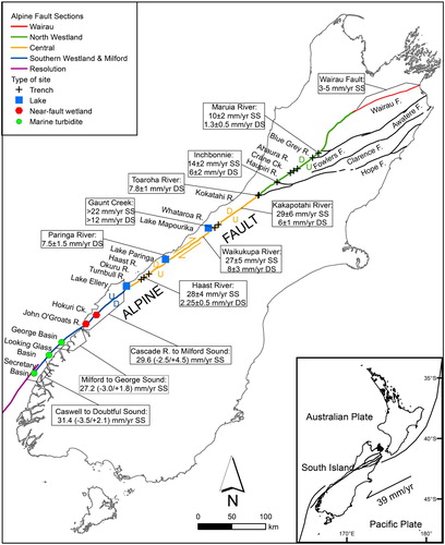
The Alpine Fault has six structural sections, three onshore, one that straddles onshore–offshore and two offshore (Berryman et al. Citation1992; Barnes et al. Citation2005; Barnes Citation2009; Barth et al. Citation2013) (). We follow the section definitions and names presented by Barth et al. (Citation2013) who reviewed existing data to summarise the features of each fault section (see their table 1). At its northern end the Alpine Fault is known as the Wairau Fault and accommodates almost pure dextral strike-slip motion at an average rate of 3–5 mm/yr (Zachariasen et al. Citation2006). Paleoseismic records for the Wairau Fault are updated and reviewed by Nicol et al. (this issue) and are not discussed further here. The North Westland section of the Alpine Fault accommodates oblique dextral-reverse slip with northward decreasing strike-slip rates ranging from 14 ± 2 mm/yr at Inchbonnie to 10 ± 2 mm/yr at Maruia River (Langridge et al. Citation2010, Citation2017). The dip-slip rate at Inchbonnie is 6 ± 2 mm/yr decreasing to 1.3 ± 0.5 mm/yr at Maruia River (Norris and Cooper Citation2001; Langridge et al. Citation2010, Citation2017). South of the junction with the Kelly Fault (the southernmost strand of the Marlborough Fault System), the Central section of the Alpine Fault has an average rate of dextral strike-slip of 28 ± 4 mm/yr, which is considerably higher than the fault sections to the north (mean rate calculated from data in Norris et al. Citation2001). Rates of dip-slip vary along strike, ranging from 7.8 ± 1 mm/yr in the north of this section at Toaroha River, through > 12 mm/yr adjacent to the central Southern Alps at Gaunt Creek, 7.5 ± 1.5 mm/yr at Paringa River to 2.25 ± 0.5 mm/yr at Haast River near the southern margin of the section (Norris and Cooper Citation2001). The South Westland section also accommodates oblique dextral motion but, unlike the Central and North Westland sections, the net uplifted side is to the northwest. The most recent long-term (c 270 kyr) dextral strike-slip rate reported for this section is 29.6 (−2.5/+4.5) mm/yr and the uplift rate is 2.6 (−0.4/+0.5) mm/yr (Barth et al. Citation2014). The strike-slip rate is notably higher than the 23 ± 2 mm/yr reported by Sutherland et al. (Citation2006). Barth et al. (Citation2014) critiqued several of the piercing points used by Sutherland et al. (Citation2006) to estimate displacements and argue that their estimate is more representative of the long-term rate. Offshore, the Alpine Fault consists of the southern end of the South Westland section, and two right-stepping fault sections named the Nancy (a short, 35 km long section in the region of overlap between the South Westland and Resolution sections) and Resolution sections () (Barnes et al. Citation2005). The strike-slip rate on the offshore South Westland section is 27.2 (−3.0/+1.8) mm/yr and increases to 31.4 (−3.5/+2.1) mm/yr towards the southern extent of this section (Barnes Citation2009).
Figure 1. The Alpine Fault in the South Island of New Zealand showing the sectioning of the fault, paleoseismic sites, and along-strike variation in slip rates (Norris et al. Citation2001; Barnes Citation2009; Langridge et al. Citation2010, Citation2017; Barth et al. Citation2013, Citation2014). See Barnes et al. Citation2005, Citation2013; Barnes Citation2009) for details of the offshore sections.
Review of on-fault paleoseismic records
Twenty-two trenches have been excavated across the Central and North Westland sections of the Alpine Fault at 13 sites between the Turnbull and Matakitaki rivers. Trench sites have been predominantly located in alluvial environments, such as terraces and fans, which preserve clear recent scarps and fluvial geomorphology offset by the fault (). These trenches generally record up to the last three surface-rupturing earthquakes on the fault that are dated by (a few) bracketing radiocarbon dates. The relatively low number of earthquakes recorded in the stratigraphy of these trenches by global standards is a result of high sedimentation rates, shallow ground water, and high single event displacements. Here, we summarise earthquake ages from paleoseismic trenches, and, where available, single event displacements. To ensure consistency across data sets collected over a timespan of > 20 yr, we update chronologies using Bayesian age modelling to integrate age control from 14C dates calibrated using the most recent calibration curve (SHCal 13; Hogg et al. Citation2013) and stratigraphic constraints using the Sequence prior model in OxCal 4.3 (Bronk-Ramsey Citation2001). Developments in the Southern Hemisphere calibration curve have superseded the need to report conventional radiocarbon ages (CRA) < 200 yr BP as modern. Combined, the new calibration curve and age modelling enable useful age constraint to be established for the most recent earthquakes, which was not possible at the time the data was generated.
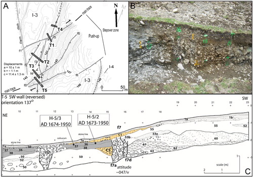
Figure 2. Example of a typical trench site excavated across the Alpine Fault where it transects alluvial landforms. A , Alpine Fault traces and trench sites (T1–T5) at Inchbonnie on the North Westland section. B , Photograph showing the shear zone of the Alpine Fault exposed in the southwest wall of T5. C , Stratigraphic and geochronological constraint for the most recent event at this location (see text for description).
Matakitaki River
Two trenches were located across the surface trace of the Alpine Fault where it transects fluvial terraces on the western side of the Matakitaki River (Yetton, Citation2002). Both trenches contain stratigraphic evidence of at least the last two ruptures at this location. There are three CRAs from the first trench. The first is a 115 ± 63 yr BP date (Wk9760) on charcoal from faulted overbank fluvial silts that predate the most recent earthquake (MRE). The second CRA was 205 ± 43 yr BP (Wk9758) from a branch with intact bark and 0–10 years of sapwood, extracted from unfaulted colluvium that overlies faulted sedimentary units. The third was 151 ± 38 yr BP (Wk9757) from a small branch extracted from buried forest litter within a fault furrow (interpreted as contamination from historical logging by Yetton, Citation2002). This age post-dates the MRE at this location. An additional constraint comes from the lack of documented historical rupture of the Alpine Fault since AD 1840. The age model produced a 95% highest probability density function (95% HPDF) for the MRE of AD 1843–1700 ().
Figure 3. Space and time diagram showing the most recent earthquake (red), penultimate (yellow) and antepenultimate (green) earthquake age probability density functions derived from the Bayesian age modelling of trench stratigraphy and 14C dates.
A single CRA was produced from the second trench. It is 668 ± 39 yr BP (Wk9761) and is from a branch trapped in the shear zone that was interpreted by Yetton (Citation2002) to be related to the MRE. The branch predates the rupture and provides an age for the MRE of AD 1837–1516 when calibrated and modelled, along with the historical constraint. Although very broad, this age agrees with the earthquake date from the Matakitaki 1 trench, indicating that the MRE on the Alpine Fault in this location could have occurred after AD 1700.
Maruia River
At Maruia River, a U-shaped trench was excavated across the surface trace of the Alpine Fault (Yetton Citation2002). The trench was located in the tread of the most recently abandoned terrace of the Maruia River that hosts a channel offset 1.3 ± 1 m across the Alpine Fault trace. The trench shows evidence of the MRE at this site but the CRAs that bound the rupture are on fragments of charcoal that have obviously suffered from reworking. Charcoal from deposits at the base of the channel fill from an unfaulted channel provided a CRA of 805 ± 49 yr BP (Wk9623), whereas charcoal from faulted gravely, sandy silt has ages of 477 ± 58 yr BP (Wk9325) and 609 ± 57 yr BP (|Wk9326). Yetton (Citation2002) derives a maximum inbuilt age for the species that produced the charcoal in an attempt to use these dates as constraint for the timing of the MRE. However, the charcoal was extracted from sediment that experienced fluvial reworking and has an unknown residence time within the catchment before deposition. Consequently, the youngest CRA (Wk9325) provides a maximum for the MRE of sometime after AD 1625–1399.
Blue Grey River
Constraints on the timing of the last surface rupture were produced from a hand-dug trench across the active trace where it crosses alluvial terraces on the north bank of the Blue Grey River (Yetton Citation2002). The trench contains stratigraphic evidence of the last earthquake, which also offset fluvial channels that cross the fault by an average of 1.0 ± 0.3 m (Yetton Citation2002). The age of the rupture is bounded by a CRA of 281 ± 56 yr BP (Wk10000) from branch fragments trapped in the shear zone, and a CRA of 219 ± 57 yr BP (Wk10001) from charcoal within colluvium immediately overlying the upper terminations of the fault strands. An additional constraint comes from the lack of documented historical rupture of the Alpine Fault since AD 1840. The age model produced a 95% highest probability density function (95% HPDF) for the MRE of AD 1843–1567 ().
Ahaura River
A single trench at Ahaura River was excavated across the westernmost of two Alpine Fault surface traces, immediately south of Coates Creek (Yetton et al. Citation1998). Faulted overbank silts are overlain by silty, sandy angular fine schist gravels that are interpreted as post-seismic alluvium from creek aggradation. A CRA of 380 ± 60 yr BP (Wk5378) from a small branch located at the base of the angular schist gravels provides a minimum age for the MRE at this site. Branches from near the base of an unleached brown peat with minor sand and schist gravel produced a CRA of 127 ± 48 yr BP (Wk5528). Bayesian age modelling of this sequence provides an age for the last event of AD 1642–802. However, only the western-most of the two Alpine Fault traces was trenched by Yetton et al. (Citation1998) and it is possible that subsequent rupture only occurred on the second trace or is not clearly expressed in the hand-dug trench. Consequently, it is impossible to conclude that the MRE occurred in AD 1642–802 and further on-fault paleoseismic investigation is required ().
Crane Creek
A single trench was hand-dug across a fault furrow that Yetton et al. (Citation1998) infer as the youngest surface trace of the Alpine Fault, immediately south of Crane Creek. The trench records stratigraphic evidence of the rupture that generated the fault furrow. A shear zone is overlain by silty sand with fine schist gravel and Yetton et al. (Citation1998) infer that it is scarp-derived colluvium. Two CRAs from twigs within the colluvium provide ages of 380 ± 25 yr BP (Wk5263) and 360 ± 50 yr BP (Wk54489). These ages immediately post-date the rupture recorded in the trench. Yetton et al. (Citation1998) infer that this is the most recent earthquake on the Alpine Fault at this location. The timing of this event is further constrained by the presence of a small landslide from the fault scarp that buries the trenched fault furrow and is not faulted, indicating that it post-dates the rupture that formed the furrow. Ring counts from two Fuscopora fusca trees growing at the site provide a minimum age for the landslide of 295 yr. The landslide deposit buried a Dacrydium cupressinum tree that is now tilted and has an age of 540 yr. Tree ring counts demonstrate that this fault trace has not ruptured in the last c. 300 yr (Yetton et al. Citation1998). These constraints provide a modelled age for the earthquake of AD 1601–1110 (). A fault furrow similar to the one that was trenched is located immediately west of the trench location at the base of the mapped Alpine Fault scarp (Yetton et al. Citation1998). It is possible that a more recent rupture created this furrow and, as at the Ahaura River site, further on-fault paleoseismic investigation is required to confirm that the last rupture of the Alpine Fault at this location was in AD 1601–1110.
Haupiri River
A hand-dug pit was located across the only surface trace of the Alpine Fault immediately north of the Haupiri River where the toe of a small landslide from the fault scarp has been offset from the scarp by 5–6 m (Yetton et al. Citation1998). The trench stratigraphy reveals sheared gravels that are overlain by unfaulted scarp-derived colluvium, which in turn is overlain by brown peat. Yetton et al. (Citation1998) infer that this sequence records the MRE of the Alpine Fault. CRAs of 210 ± 50 yr BP (Wk5529) from twigs and leaves trapped within the shear, and 134 ± 46 yr BP (Wk5379) from twigs and small branches from the base of the colluvium, provide bounding age constraints for the MRE at this location. Bayesian age modelling indicates the last rupture at Haupiri River occurred in AD 1843–1689 ().
Inchbonnie
Five paleoseismic trenches were excavated across the Alpine Fault at Inchbonnie to estimate slip rates and to assess the timing of late Holocene earthquakes (Langridge et al. Citation2010). The stratigraphy of the site is dominated by a fining-upward sequence of alluvial deposits from the Taramakau River. Based on faulting and folding, and the presence of colluvial wedges, the trenches reveal evidence for five to seven rupture events. However, due to a paucity of organic material for radiocarbon dating, only an estimate for the most recent event is possible. Trench 5 (), which crosses the upper end of a broad fault zone associated with a stepover in the Alpine Fault, displays evidence for at least two faulting events. The youngest of these is associated with a metre-wide fault zone that juxtaposes alluvial gravel in the scarp against overbank silt deposits. The fault zone, gravel and silts are overlain by a wedge-shaped gravel unit that is interpreted as a scarp-derived colluvial wedge. Two charcoal samples from within the upper most silt unit with CRAs of 174 ± 20 yr BP (NZA29625) and 167 ± 25 yr BP (NZA29626) provide constraint on the timing of the MRE of AD 1841–1691 when modelled with stratigraphic and historic constraints. Local estimates of single-event dextral displacement along the fault near Inchbonnie are c. 5–7 m (Berryman et al. Citation1992).
Kokatahi River
On the northern bank of the Kokatahi River, the Alpine Fault has two recent surface traces that were both trenched by Yetton et al. (Citation1998). The trench stratigraphies are similar to those at Toaroha River and are characterised as alluvium composed of gravels and overbank silts, and scarp-derived colluvium. Both trenches record offset that relates to at least the last two ruptures at this location. Maximum age constraint for the timing of the last two ruptures is derived from two CRAs from Kokatahi 1 trench: (1) a CRA of 490 ± 40 yr BP (Wk 5470) from a Metrosideros umbellata log that had sapwood removed by abrasion and was extracted from channel sands; and (2) 120 ± 40 yr BP (Wk 5471) from a Dacrycarpus dacrydiodes root that had its upper termination sheared and was in growth position within the flood channel sands, under the oblique thrust fault formed by the penultimate earthquake. Minimum age constraint for the penultimate rupture and maximum age constraint for the MRE is provided by a CRA from the Kokatahi 2 trench of 220 ± 40 yr BP (Wk5473) from a piece of decayed M. umbellata branch. This branch was extracted from a soil breccia interpreted to have formed as a product of liquefaction during the last earthquake. Minimum age constraint for the latest rupture is provided by a CRA of 93 ± 40 yr BP (Wk5469) from a small stump in growth position that was buried by flood channel sands that are inferred by Yetton et al. (Citation1998) to postdate the last rupture. Modelling of this event sequence and CRAs provides ages for the penultimate event at Kokatahi River of AD 1814–1684 and for the MRE of AD 1845–1703 ().
Toaroha River
Two trenches were excavated across the surface trace of the frontal thrust of the Alpine Fault at Toaroha River (Yetton et al. Citation1998). The stratigraphy of the Toaroha 1 trench is characterised by sequences of alluvium, overbank silts, colluvium and buried soils that have been offset in at least two ruptures. Temporal constraint on the timing of these ruptures comes from both trenches. A CRA of 250 ± 50 yr BP (Wk5511) from root material within fluvial sands that were faulted by the penultimate rupture provides a maximum age for the most recent two ruptures. A branch extracted from scarp-derived colluvium that is faulted by a shear that reaches the surface provided a CRA of 166 ± 42 yr BP (Wk5512) and post-dates the penultimate rupture while pre-dating the MRE. Wood and charcoal collected from near the ground surface (Wk 5510) provided an age of post-AD 1950. When modelled, the stratigraphic sequence and calibrated CRAs return ages of AD 1841–1687 for the MRE and AD 1833–1624 for the penultimate rupture ().
Only the MRE is constrained by CRAs in the Toaroha 2 trench. A maximum constraint for the last rupture comes from three CRAs including 210 ± 50 yr BP (Wk 5513) from the outer most 20 annual rings of a slightly abraded Lagarostrobos colensoi branch and 119 ± 46 yr BP (Wk 5514) from charcoal fragments. Both were extracted from overbank silts that overlie the shear from the penultimate rupture but are faulted by the shear from the last rupture. The third CRA is 79 ± 47 yr BP (Wk 5515) from charcoal extracted from a paleosoil that was faulted by the last event. When modelled, the stratigraphy and CRAs from the Toaroha 2 trench provide a date of AD 1844–1696 for the most recent rupture, which is consistent with the event chronology for Toaroha 1 ().
Whataroa River
A single 14 m long trench excavated across a 1.2 m high, northeast-trending scarp of the Alpine Fault’s frontal trace where it cuts the true left (southwest) side of the Whataroa River floodplain provides evidence for the most recent rupture at this location (Langridge et al., this issue). The trench stratigraphy is characterised by a fining upward sequence of alluvial gravels, sands and silts capped by soils and anthropogenic deposits. Faulting from the most recent event is recorded in the stratigraphy by distinct shear bands within the gravels that correlate with truncated sand beds that are offset across the fault zone. The fault tips are overlain by deformed silts that have structures consistent with ductile processes and liquefaction. A maximum age for the MRE is constrained by a radiocarbon date on humified wood extracted from the deformed silts that overly the shear zone, which provides a CRA of 160 ± 19 yr BP (NZA 59059). This maximum age is complimented by a minimum age from dendrology of AD 1751 ± 10 for the abandoned alluvial surface that was faulted by the earthquake. The OxCal model provides an age for the MRE at Whataroa River of AD 1760 1677.
Gaunt Creek
A single excavated exposure of the Alpine Fault at Gaunt Creek on the Central section of the Alpine Fault reveals mylonites overlain by terrace alluvium that have been thrust over colluvial units and are separated from them by a 5–50 cm thick clay-rich gouge zone (De Pascale and Langridge Citation2012). The fault tip and scarp are draped by an unfaulted colluvial wedge and alluvium. The MRE is recorded by the unfaulted colluvial wedge that drapes the fault tip and the timing is constrained by two 14C dates. A date of 115 ± 15 yr BP (NZA36252) on organic soil that overlies the colluvial wedge provides a minimum bounding age for the MRE, while a date of 2917 ± 30 yr BP (NZA36168) on organic soil from faulted colluvial units underlying the MRE wedge provides a maximum age. When modelled, the stratigraphy and CRAs from the Gaunt Creek trench provide a date of BC 1004 to AD 1764. De Pascale and Langridge (Citation2012) interpreted the minimum age as evidence that this trench records the AD 1717 Alpine Fault earthquake. However, the stratigraphic location of the minimum age overlying scarp-derived colluvium precludes such an interpretation. The more conservative interpretation is that the MRE in this trench could have occurred at any time during the last 3000 yr.
Haast, Okuru and Turnbull rivers
A total of five trenches were excavated across the Alpine Fault where it crosses alluvial terraces formed by the Haast, Okuru and Turnbull rivers on the Central section. At each site fault scarps have formed by incremental displacement of the terrace surface that records three faulting events. Cumulative displacements of channel geomorphology suggest 7–9 m single event surface rupture displacements at the Haast and Okuru rivers in these earthquakes. Faulting is recorded by displaced over-bank fluvial deposits, colluvial wedges and soils. The original published ages for these earthquakes were AD 1774–1403, AD 1371–1211 and AD 1066–688 (Berryman, Cooper et al. Citation2012). The trench chronologies were derived by combining 14C dates from stratigraphy correlated across the five trench sites, from three discrete river systems separated by > 12 km (Berryman, Cooper et al. Citation2012). Two-thirds of the 14C dates were excluded from the original analysis because they contained or were thought to contain reworked carbon from older stratigraphic layers but in some instances, it is unclear why dates were excluded.
Howarth et al. (Citation2016) re-evaluated the trench chronology using a simple a priori rule set that improved the transparency of the age modelling process. These rules included: (1) dates that were modern or on bulk sediment were excluded to avoid dates contaminated with modern or old carbon; (2) no attempt was made to correlate 14C dates stratigraphically between trenches separated by kilometres because individual sedimentary units cannot be reliably correlated between sites separated by these distances; and (3) if more than half of the 14C dates on a particular sample fraction (e.g. groups of seeds) at an individual trench site were regarded as inconsistent with the stratigraphy by the original authors, then that sample fraction was excluded from the analysis. The revised paleoearthquake chronology provided ages for the MRE, penultimate and antepenultimate earthquakes. These were AD 1840–1377, AD 1404–1156 and AD 1185–1029 at the Haast site, and AD 1795–1502, AD 1645–1345 and AD 1390–946 at the Okuru site. Only the penultimate and antepenultimate earthquakes were preserved in the Turnbull trench and these date to AD 1836–1147 and AD 1161–995, respectively ().
The review of existing on-fault paleoseismic data reveals unequivocal evidence for through-going rupture in AD 1717 on the Central section at the Okuru, Haast and Whataroa river sites. The penultimate earthquake at Toaroha and Kokatahi river sites at the southernmost extent of the North Westland section also correlates to the AD 1717 rupture. These two sites also provide unequivocal evidence for post-AD 1717 rupture of the North Westland section of the Alpine Fault. North of the Toaroha and Kokatahi rivers only the MRE is dated. The timing of the MRE is variable between sites and does not correlate well with Crane Creek and Ahaura River, which provide older ages than the other sites. Previous interpretation of these trenches concluded that there was evidence for a rupture of the Alpine Fault at approximately AD 1620. The new geochronological analysis conducted here shows that these trenches provide limited evidence for rupture of the Alpine Fault in the early 1600s, although they do not preclude it. There is obviously a need for further on-fault investigation to constrain the timing of the last earthquake on this section. The ambiguity on MRE timing introduced when only one fault trace is studied at a site with multiple traces demonstrates the need to excavate across all active traces.
Review of fault-adjacent wetland records
The high rainfall climate, steep topography and high sediment flux of the Westland region provide ideal conditions for creating and preserving sedimentary records of earthquakes in wetlands bounded by upstream-facing fault scarps. The first paleoseismic evidence for the timing of the MRE was derived from fault-proximal wetland stratigraphy near John O’Groats River (Cooper and Norris Citation1990). The maximum age for this earthquake was provided by two radiocarbon dates (Wk1479 230 ± 50 and Wk1480 270 ± 50 on twigs and a branch respectively) immediately underlying a transition from peat to clastic sediments, inferred to be scarp-derived colluvium, in a fault-bounded sag pond. A minimum age for this event (266 + 90–60 yr) was provided by estimates of tree age for undamaged beech trees growing on the nearby fault scarp at John O’Groats River. An updated calibration of the radiocarbon dates with the ShCAL13 curve and inclusion along with the minimum constraint in a Bayesian age model provides an age of AD 1819–1646 for the MRE at this site. This early paleoseismic study set the context for development of the longest paleoseismic record for the Alpine Fault produced from two fault-adjacent wetland sites on the South Westland section at Hokuri Creek and 20 km further south at John O’Groats River () (Berryman, Cochran et al. Citation2012; Clark et al. Citation2013; Cochran et al., Citation2017).
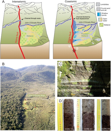
At these sites, the Alpine Fault, although dominantly strike-slip, has a small component of vertical slip that causes net uplift to the northwest (i.e. opposite sense to that observed on the Central and North Westland sections) so drainage from mountains to the east is impeded by the fault scarp. Hokuri Creek and John O’Groats River have had to flow through channels incised into the fault scarp that rises to 15 m above the valley floor. Therefore, coseismic movement is interpreted to result in offset of the river channel and flooding of the valley floor on the upstream side of the fault until the new scarp is eroded or a new channel established (). Interseismically, much of the valley floor on the upstream but downthrown side of the fault is a wetland environment accumulating peat. Immediately after an earthquake, the wetlands are flooded and catchment-derived silt and sand are deposited across the valley floor. The stark contrast between the interseismic peats and post-seismic silts enabled earthquake horizons to be identified (). Both sediment types contain organic components such as leaves, seeds and reed fragments that were used to radiocarbon date the sequences.
Figure 4. Summary of fault-adjacent wetland sedimentary records of past earthquakes. A , Conceptual model for the recording of earthquakes at Hokuri Creek and John O’Groats River. During the interseismic period, the river flows across the fault scarp and a wetland exists on the upstream and downthrown side of the fault. At the time of an earthquake, movement on the fault blocks the river and causes the wetland to be flooded. B , View of John O’Groats River valley in the current interseismic period looking northeast along the scarp of the Alpine Fault. C , Example of cyclic stratigraphy in outcrop at Hokuri Creek and D: in cores from John O’Groats wetland. Panel A reproduced from Cochran et al. (Citation2017).
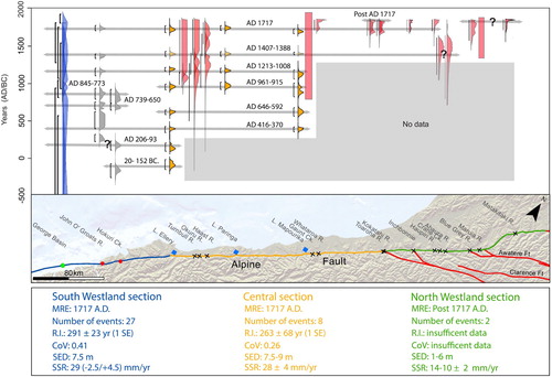
The joint earthquake record from Hokuri Creek and John O’Groats wetland consists of 27 earthquakes over the past 8000 years (Cochran et al. Citation2017; ). Twenty-two earthquakes were identified from peat–silt couplets in outcrops of a fault-adjacent paleo-wetland at Hokuri Creek (Berryman, Cochran et al. Citation2012). These earthquakes span a period of 1000–8000 yr ago. Seven earthquakes over the last 2000 years were found in cores from the fault-adjacent modern wetland at John O’Groats River (Cochran et al. Citation2017). Two earthquakes overlap in time between the two sites and are considered to represent the same events. The earthquakes occur relatively regularly in time with a coefficient of variation (CoV) of 0.41 and an average recurrence interval of 291 ± 23 yr (Cochran et al. Citation2017).
Figure 5. Ages of major, surface-rupturing earthquakes on the South Westland section of the Alpine Fault as recorded in fault-adjacent wetlands at Hokuri Creek (grey curves) and John O’Groats River (black curves). Curves are the probability density functions of the modelled ages. Two earthquakes were recorded at both sites as noted by the square brackets (Berryman, Cochran et al. Citation2012; Cochran et al. Citation2017).
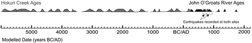
It is possible that non-Alpine Fault earthquakes or non-seismic catchment disturbance events are included in the record. However, given that surface rupture and repeated creation of accommodation space are required for the long-term accumulation of cyclic stratigraphy observed at these sites, it is unlikely (Clark et al. Citation2013). It is also possible that some Alpine Fault surface-rupturing earthquakes are missing from the record. The exact magnitude of events recorded at these sites is unknown. However, single event displacement measurements at Hokuri Creek indicated that the northwestern block of the Alpine Fault moved 7.5 ± 1 m dextrally and 1 ± 0.5 m vertically in the most recent earthquake (Clark et al. Citation2013). The most recent event at John O’Groats River correlates with the AD 1717 earthquake that is calculated to have been a whole-fault rupture of magnitude 8.1 (De Pascale and Langridge Citation2012).
Fault-adjacent wetland records of earthquakes have advantages and disadvantages over more conventional on-fault and off-fault records. They are not as unequivocally tied to the fault of interest as are earthquake records from trenches across the fault, but they are more directly linked than records from distal sites that may record events from several sources. This is because, although the sediments holding the earthquake record do not cross the fault and are not offset when it moves, they abut the fault on the downthrown side and rely on fault offset creating accommodation space to record earthquakes. They have more continuous sedimentation and a higher likelihood of containing dateable material than trenches, but sedimentation is unlikely to be as continuous as lake records. Fault-adjacent earthquake records in effect bridge the gap between on-fault and off-fault records to improve understanding of earthquake recurrence behaviour and seismic hazard.
Review of fault-proximal lake records
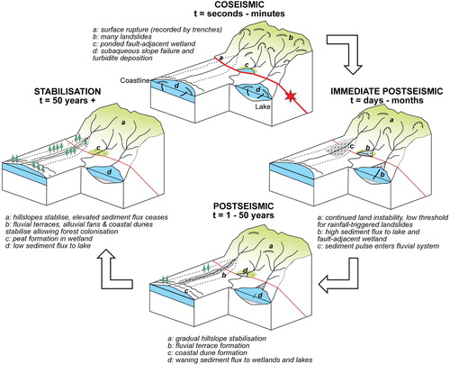
Lakes situated immediately adjacent to the Alpine Fault are ideally placed to record the impacts of seismic shaking caused by rupture of the Alpine Fault in their sedimentary archives. In these lakes, seismic shaking is recorded as an event sequence of a turbidite formed by coseismic subaqueous slope failure, overlain by sets of hyperpycnites representing elevated fluvial sediment fluxes from earthquake-induced landslides in the lake catchments. Deposits formed by seismic shaking are separated by layered silts that represent deposition during periods of relative quiescence in the lake catchments (). These layered silts contain abundant terrestrial leaf macrofossils that allow earthquake event sequences to be dated with decadal precision using Bayesian age depth modelling (Howarth et al. Citation2012, Citation2014, Citation2016). The seismic origin of event sequences has been demonstrated by: (1) establishing that events were synchronous between three lakes separated by 150 km, (2) correlating the timing and sedimentology of these events with known ruptures of the Alpine Fault, and (3) discounting other seismic and aseismic triggers such as extreme storms (Howarth et al. Citation2012, Citation2014, Citation2016).
Figure 6. Summary of the fault-proximal lake sedimentary records. A , Example of deposition over a seismic cycle from Lake Paringa (Mcs = mass of clastic sediment). B , Conceptual model of the processes driving sediment production, flux and deposition over an Alpine Fault seismic cycle. Modified from Howarth et al. (Citation2012).
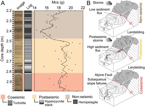
Isoseismal modelling of well-constrained paleoearthquakes has been used to demonstrate that strong shaking intensities (MM > 6) destabilise slopes within these lake basins causing subaqueous mass-wasting and deposition of turbidites (Howarth et al. Citation2014). When shaking intensities exceed MM 9 extensive earthquake-induced landsliding is triggered on lake catchment hillslopes, driving dramatic increases in sediment flux that form hyperpycnite sets in the lake basins (Howarth et al. Citation2014). Hence, the composition of event sequences can be used to distinguish between strong (MM 6) and violent (MM 9) shaking at a lake site. Event sequences that contain evidence for both subaqueous mass-wasting and increased fluvial sediment flux map the spatial extent of MM 9 shaking and hence fault rupture length by correlating between sites.
The high-intensity shaking (MM 9) events (henceforth termed earthquake deposits) recorded in lakes Ellery, Mapourika and Paringa () provide a record of rupture on the Central Alpine Fault in AD 1726–1690 (the AD 1717 earthquake), AD 1407–1388, AD 1219–1009, AD 961–915, AD 646–592 and AD 416–370. The greater temporal span of the Lake Ellery cores captures two additional earthquake deposits that provide evidence for MM 9 shaking in AD 206–93 and BC 20–152 ().
Figure 7. Space and time diagram showing the lake-derived rupture length proxy and reconstructed along-strike rupture extent for Alpine Fault earthquakes that ruptured the Central and/or the South Westland sections of the Alpine Fault. Red age probability density functions (PDFs) represent the timing of MM 9 shaking events recorded at each lake site, yellow age PDFs are MM 6 shaking and grey age PDFs present the timing of surface-rupturing earthquakes on the South Westland section from fault-adjacent wetland sequences. Horizontal lines represent rupture extents inferred on the basis of event synchronicity, within error of the chronology, between sites (after Berryman, Cochran et al. Citation2012; Howarth et al. Citation2012, Citation2014, Citation2016; Cochran et al. Citation2017).
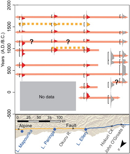
The MRE, penultimate and antepenultimate MM IX shaking events along the Central section correlate with the less well constrained timings of rupture in the Haast, Okuru and Turnbull trenches (Howarth et al. Citation2016), and with fault-adjacent wetland evidence from John O’Groats (; Cochran et al. Citation2017). These correlations suggest that both the Central and South Westland sections ruptured during these last three earthquakes. However, further back in time, lack of correlation in the timing of earthquakes from the Lake Ellery, Hokuri Creek and John O’Groats wetland records suggests that the Central and South Westland sections do not always rupture together ().
Two shaking events recorded in the lakes cannot be unequivocally related to rupture of the Alpine Fault. The first is a MM 8 > x>MM 6 shaking event recorded in all three lakes in AD 1594–1549 (). The low shaking intensity along c. 150 km of the Alpine Fault suggests that the Alpine Fault did not rupture adjacent to the lake sites at this time, implying a non-Alpine Fault source for this earthquake. The second is recorded by an AD 1024–967 MM 9 event in Lake Ellery that correlates with the deposition of a small turbidite in core PA5 adjacent to the Collie Creek delta in Lake Paringa in AD 1010–945 (Howarth et al. Citation2016). Based on interpretation of the sedimentology, the event is consistent with MM 9 shaking at Lake Ellery and reduced shaking at Lake Paringa. Therefore, the scenario is most consistent with an earthquake near Lake Ellery, but this cannot be unequivocally linked to rupture of the Alpine Fault. At this stage, lake records provide evidence for eight Alpine Fault earthquakes recurring on average every 263 ± 63 yr (1SE) with a CoV of 0.26.
The regional lake record has three major advantages over previous paleoseismic data for the Alpine Fault. First, lake cores record regional coseismic shaking within a continuous stratigraphic sequence that captures every event capable of generating high regional shaking intensities. This affords considerable advantage over trenching studies that have the potential to miss earthquakes, particularly in strike-slip settings, if offset stratigraphy is eroded, if displacement is accommodated on a different strand of the fault, or if cryptic offsets in the trench stratigraphy are not identified (McCalpin et al. Citation2009). The continuous nature of the lake records also allows earthquakes separated by only weeks to months to be distinguished, meaning single long ruptures can be distinguished from multiple short ruptures closely spaced in time. Second, the lake record can be dated to produce high-precision chronologies for the timing of coseismically formed deposits, whereas chronologies from trench records are usually restricted to bracketing ages with large uncertainties because of the scarcity of organic material (Yetton et al. Citation1998; Berryman, Cooper et al. Citation2012). Lastly, the lake cores record the duration and relative magnitude of the post-seismic landscape response to earthquakes that can be readily recognised, correlated between lakes, and dated precisely. On average post-seismic increases in sediment flux, and hence landscape disturbance, persist for 50 ± 15 years (95% C.I.) after rupture of the Alpine Fault (Howarth et al. Citation2012, Citation2014).
Landscape disturbance evidence of Alpine Fault earthquakes
Indirect evidence of Alpine Fault earthquakes recorded as regional landscape disturbance has been widely used to better constrain the timing of fault rupture recorded in trenches (Yetton Citation1998; Wells et al. Citation1999). However, the relationship between these proxies and the timing of rupture remains uncertain because they record the post-seismic landscape response to earthquakes, which can persist long after the initial event. The precise ages for the end of post-seismic landscape response produced from the lake records described above provide an opportunity to evaluate the earthquake chronologies derived from regional landscape disturbance (e.g. Yetton et al. Citation1998; Wells et al. Citation1999).
Even-age forest cohort establishment
Regional-scale disturbance is documented in a record of even-age forest cohort establishment (Wells et al. Citation1998, Citation1999). Cohort establishment dates disturbance events because trees establish on disturbed or newly created landscape surfaces, landslides, fluvial terraces and floodplains, producing stands of similarly aged trees, which can be dated using dendrochronology (Wells et al. Citation1998, Citation1999, Citation2001). The age for the initial disturbance event is calculated by taking the oldest tree from the cohort and adding an estimate of the number of years taken for trees to establish and grow to the c. 1 m coring height. Episodes of regional disturbance have been reported between AD 1740–1690, AD 1655–1605 and AD 1495–1435 (Wells et al. Citation1999). These age ranges are based on a nominal error of ± 25 yr, which Wells et al. (Citation1999) computed using an assumed ± 5% counting error, but it must be noted that the ages are not substantiated by a formal error analysis (Wells et al. Citation1999).
In the course of this review, a formal error analysis for the dates has been conducted using the data of Wells et al. (Citation1999) to produce 95% HPDF range ages, comparable with the age ranges established for both the timing of Alpine Fault earthquakes and the cessation of post-seismic landscape responses from the lake chronologies. The error analysis accounted for the probable counting error of ± 5% reported by Wells et al. (Citation1999) and the 2σ error for the reported mean establishment time. This estimation of error is conservative given that published values for counting errors associated with increment cores from both Dacrydium cupressinum and Dacrycarpus dacrydioides are closer to ± 10% (Duncan Citation1989; Stewart and White Citation1995). There may be further age underestimates because the sample size used to establish the mean colonisation time for podocarps was low (n = 9) and the mean 23-yr colonisation time from these nine sites is relatively short in comparison with many published colonisation times that range up to 80 yr for forest in Westland (Wells et al. Citation1998).
The new error analysis indicates that the regional disturbances leading to even-age forest cohort establishment occurred between AD 1767–1668, AD 1679–1601 and AD 1505–1416 (). These age ranges either overlap or post-date ages for Alpine Fault earthquakes or non-Alpine fault shaking events (MM 7 in AD 1594–1549) (). The variation in regional tree colonisation ages with respect to the trigger event indicates that while they record the occurrence of landscape disturbance they do not provide reliable ages constraint for the event nor do they necessarily record Alpine Fault ruptures. This is the case for the AD 1679–1601 tree cohort age which immediately post-dates the regional MM 7 shaking event recorded in the lake records (AD 1594–1549).
Figure 8. Temporal relationship between lake-derived records of rupture on the Central section of the Alpine Fault and episodes of landscape disturbance and stabilisation. Yellow age probability density functions (PDFs) are dune formations dated by dendrochronology (Wells and Goff, Citation2006, 2007). Green age PDFs are even-age tree cohorts on landslides, terraces and floodplains, blue age PDFs are even age cohorts on alluvial terraces on the Karangarua River (Wells et al. Citation2001) and grey age PDFs are rockfalls within the Southern Alps dated by lichenometry (Bull et al., Citation1996). Vertical red bars represent the 95% highest PDF range for Alpine Fault rupture, blue vertical bars represent the duration of the post-seismic landscape response constrained by lake records (Howarth et al. Citation2012, Citation2014, Citation2016), the yellow bar is a non-Alpine Fault earthquake (Howarth et al. Citation2016) and the grey bar is a non-seismic landscape disturbance event (Howarth et al. Citation2014).
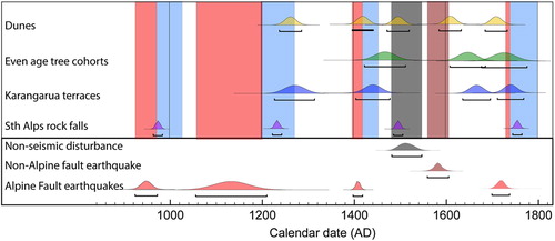
Importantly, the AD 1505–1416 regional tree colonisation age overlaps with the end of post-seismic sediment flux recorded in the lake records following the penultimate Alpine Fault earthquake on the Central section (). Regional disturbance ages derived from even-age forest cohort data take into account the time taken for trees to colonise a site after a disturbance, but they do not account for the prolonged period of disturbance that follows an earthquake (Wang et al. Citation2015; Croissant et al. Citation2017). We argue that even-age forest cohort establishment provides ages for landscape stabilisation at the end of a post-seismic landscape response rather than for the initial trigger event.
Establishment of even-age forest cohorts has also been used to determine the age of an alluvial terrace sequence in the lower Karangarua River valley (Wells et al. Citation2001), which is generally accepted to be the product of episodic uplift on the Alpine Fault (Adams Citation1980; Tonkin and Basher Citation1990). These alluvial river terraces were abandoned in the periods between AD 1767–1711, AD 1695–1635, AD 1477–1403 and sometime before AD 1314–1226. The timing of terrace abandonments in the 1700s and 1400s overlaps with age ranges for the corresponding Alpine Fault earthquakes and end of post-seismic sediment fluxes, although there is more overlap with the end of post-seismic sediment flux (). The terrace abandonment event in the late 1600s does not correlate with an MM 9 shaking event in the lake records, making it unlikely that the Central Alpine Fault ruptured at this time. This raises the question: how do these terraces actually form? Without coseismic offset on the Alpine Fault the AD 1695–1635 terrace cannot have formed by knick-point migration triggered by fault offset. A more likely mechanism is down-cutting caused by reduction in sediment supply at the end of a fluvial aggradation event. The aggradation that drove this terrace-forming episode may have been caused by sediment produced by widespread disturbance at Welcome Flat deep in the Karangarua catchment dated to between AD 1620–1610 by Wells et al. (Citation2001).
If terrace abandonment in the 1600s was driven by alluvial processes rather than coseismically generated knick-point migration, then it is plausible that the other terraces in the Karangarua River valley also record the end of aggradation events. Sediment produced by Alpine Fault earthquakes in AD 1717, AD 1407–1388 and AD 1219–1009 and evacuated from the catchment during the subsequent landscape response would drive a period of aggradation that ceased when the landscape stabilised, resulting in renewed fluvial down cutting and terrace formation. This mechanism explains the correlation between terrace formation and the end of post-seismic sediment flux. Under this scenario, long-term dip-slip offset on the Alpine Fault acts to preserve terraces formed by post-seismic aggradation events rather than driving knick-point migration directly.
Determining the cause of the c. AD 1620 disturbance event within the Southern Alps is difficult based on current data. The process driving the landscape disturbance must have been capable of affecting a wide area spanning the headwaters of the Wanganui River south to the Karangarua River. The regional MM 7 shaking signal from the lakes supports an earthquake trigger, which, combined with the distribution of landscape disturbance, is probably related to rupture of a fault(s) within the Southern Alps (cf. Cox et al. Citation2012). It is not possible to determine the specific source on the basis of current data.
Radiocarbon dating of regional landsliding and terrace formation
Radiocarbon dates from 19 large landslides and aggradation events in the Southern Alps and Westland region have been used as evidence for regional disturbance caused by Alpine Fault earthquakes (Adams Citation1980; Yetton Citation1998; Yetton et al. Citation1998; Wells et al. Citation1999). The compiled data appear to demonstrate three distinct clusters of landslides and terrace formation since AD 1250, with only minimal overlap between clusters. These clusters broadly correlate with the timing of the last three Alpine Fault earthquakes (Wells et al. Citation1999). However, reappraisal of this data set by Sutherland et al. (Citation2007) using relatively new statistical methods for radiocarbon date calibration showed that the observed clustering is no different to that expected from a uniform distribution of events since AD 1250. On this basis, many more ages for landslide and terrace formation events are required before clustering can be demonstrated statistically and links made to Alpine Fault earthquakes.
Ages for Alpine Fault earthquakes have also been proposed based on lichenometric dating of rockfalls and landslides east of the topographic divide in the Southern Alps (Bull Citation1996). Lichen age distributions were used to infer intensive seismic shaking at a regional scale in the periods between AD 1758–1738, AD 1499–1479, AD 1236–1216 and AD 977–957 (; Bull Citation1996). None of these events correlate with the timing of Alpine Fault earthquakes derived from fault-proximal lakes or fault-adjacent wetland records and the technique itself has been called into question (e.g. Osborn et al. Citation2015). However, it is noteworthy that they all post-date major rupture of the Central section of the Alpine Fault and correlate to the end of the post-seismic landscape responses. Like the other indirect proxies, lichenometry may record mass-movement that occurred coseismically or during the post-seismic landscape response to Alpine Fault earthquakes. The majority of sites are on the eastern side of the Main Divide > 25 km from the Alpine Fault trace. The distance of sites from the fault and their distribution throughout the alpine zone makes it possible that the lichenometric data record an increase in seismicity within the Southern Alps following major rupture of the Alpine Fault.
Episodes of coastal dune formation
Synchronous episodes of dune formation at the mouths of four major rivers on the Haast coastal plain and the Awarua River further south appear to directly post-date Alpine Fault earthquakes (Wells and Goff Citation2006, Citation2007). It has been inferred that dune formation was driven by post-seismic sediment flux from these river catchments following fault rupture, and dune formation events have been dated to the periods between AD 1831–1781, AD 1726–1678, AD 1626–1578, AD 1506–1456, AD 1438–1388 and AD 1281–1231 (Wells and Goff Citation2007). The minimum ages for dune formation were generated using the age of the oldest trees on contemporaneous dune ridges over the entire study area and the maximum age by subtracting a nominal 50 yr from the oldest tree age to allow for the time between dune formation and tree establishment (Wells and Goff Citation2007). Errors for the ages of the oldest trees are not reported but are likely to be in the order of ± 10% given the podocarp species sampled (Duncan Citation1989).
The last episode of dune formation is not regarded as the product of an Alpine Fault earthquake because it correlates with the AD 1826 Fiordland subduction zone earthquake (Wells and Goff Citation2007). The establishment times for all but two of the other dune events correlate to the timing of Alpine Fault earthquakes and the end of subsequent landscape response periods recorded in the lake data (). The two exceptions are AD 1626–1578 and AD 1506–1456 episodes of dune formation.
The AD 1626–1578 dune immediately post-dates the regional estimated MM 7 shaking event recorded in lakes Mapourika, Paringa and Ellery in AD 1594–1549 and an even-age forest cohort establishment event throughout the Central section in AD 1679–1601. This sequence of events involving seismic shaking followed by landscape disturbance and stabilisation throughout central Westland is consistent with an earthquake centred within the Southern Alps that triggered landsliding and increased sediment flux in trunk valleys but not range front catchments.
The AD 1506–1456 dune formation event correlates with the hyperpycnite stack indicative of increased terrigenous sediment flux from the lake’s watershed in cores from Lake Mapourika deposited between AD 1545 and AD 1480. This deposit is not directly underlain by any evidence for subaqueous mass-wasting (Howarth et al. Citation2014). Consequently, the catchment disturbance that resulted in the deposition of this hyperpycnite set was probably driven by a phase of climatically induced disturbance in the lake catchment. The AD 1506–1456 dune formation event also overlaps with the regional even-age forest cohort establishment period that spans most of the 1400s (Wells and Goff Citation2007). A re-evaluation of the forest cohort data suggests that two closely spaced aggradation events can be distinguished within this phase of forest establishment (Cullen et al. Citation2003; Wells and Goff, Citation2007). These correlations indicate that a large climatic event or an earthquake within the Southern Alps caused the AD 1506–1456 dune formation and widespread sedimentation in South Westland during this period (Wells and Goff Citation2007).
Lake Poerua
Lake Poerua, located on the footwall of the Alpine Fault northeast of Inchbonnie, contains a record of changing lake level controlled by aggradation of the impounding range front alluvial fan that Langridge et al. (Citation2012) infer is driven by landscape disturbance associated with Alpine Fault earthquakes. Relatively rapid lake level rise is recorded by cohorts of drowned lake-marginal Dacrycarpus dacrydioides. Tree death ages determined using radiocarbon dates and wiggle match age modelling in OxCal provide timings for fan aggradation of AD 1807–1766 and approximately AD 1626–1459. The most recent of these post-dates the AD 1717 earthquake and the latter the approximately AD 1400 rupture, although the latter also overlaps with the AD 1545–1480 sedimentation event in Lake Mapourika and dune formation on the Haast coastal plain so its origin remains ambiguous. Nonetheless, the Lake Poerua record provides supporting evidence for our interpretation that ages for earthquake-related landscape disturbance may actually date landscape stabilisation rather than the triggering event.
When on-fault, fault-proximal lake records and landscape disturbance proxies are considered together, there is little evidence for rupture of the Central section of the Alpine Fault during the 1600s. Further, the on-fault trench studies from the North Westland section initially used to argue for a 17th century earthquake no longer provide convincing evidence for rupture on the Alpine Fault at this time. A re-analysis of existing even-age forest cohort data from the floodplains of the Wanganui, Whataroa, Waiho and Ohinemaka rivers showed two major floodplain aggradation events. Floodplain aggradation associated with the penultimate aggradation event in the 1600s was much more extensive than aggradation associated with the AD 1717 earthquake (Cullen et al. Citation2003). The extent of the penultimate aggradation event is probably related to the compounded impact of two perturbations that are unrelated to rupture of the Alpine Fault, i.e. sediment mobilised by both an earthquake centred within the Southern Alps in AD 1594–1549 and a large climatic event within the Southern Alps in AD 1506–1456.
Offshore turbidite paleoseismology
There is currently no direct paleoseismic evidence of past earthquakes on the offshore sections of the Alpine Fault (cf. Barnes and Pondard Citation2010). Turbidite paleoseismology conducted on cores from pull-apart basins formed along the Alpine Fault provide insights into the frequency of shaking events from large earthquakes associated primarily with the offshore Alpine fault and Fiordland subduction zone (Barnes et al. Citation2013). Barnes et al. (Citation2013) report turbidite records from the George, Looking Glass and Secretary basins. Cores from these basins contain stacks of source proximal sand–silt turbidites that have no intervening hemipelagite. Strong ground motion from large earthquakes was determined as the likely trigger mechanism by eliminating other potential triggers such as storm waves. Such sequences are atypical of the sedimentary records classically used for turbidite paleoseismology that contain turbidites inter-bedded with hemipelagite (cf. Goldfinger et al. Citation2007; Goldfinger Citation2011) and preclude the generation of high-resolution chronologies for along strike correlations.
Chronology for the Fiordland turbidite cores was generated in an unconventional manner using 14C dates from reworked planktonic foraminifera within turbidite deposits. Although on reworked material, the ages were consistent with the stratigraphic ordering of events. By assuming that turbidite sediments had a low residence times in source areas, less than the return time of shaking, an age model was generated using a modified sequence model in OxCal (Barnes et al. Citation2013). The approach allowed turbidite ages to be constrained with a precision of between 100 and 600 yr, nearly an order of magnitude lower than those from the lake records described above. None the less, the chronologies allow the recurrence intervals for strong shaking to be reconstructed at the three sites. These are c. 190 yr at George Basin (based on seven turbidites since approximately AD 610), c. 160 yr at Looking Glass Basin (based on 12 turbidites since BC 300) and c. 150 yr at Secretary Basin (based on eight turbidites since AD 556). Recurrence intervals become less periodic from north to south, with George Basin exhibiting comparative periodicity to onshore paleoseismic records for the South Westland section (CV 0.3), whereas Secretary Basin has almost random occurrence of shaking (CV 0.99).
Although it is not possible to make meaningful correlations between specific event ages from the onshore and offshore records due to the broad probability density functions characteristic of the offshore data, it is noteworthy that the number and general timing of events agree between the terrestrial John O’Groats site and the northern most turbidite record at George Basin (). The increase in the frequency of shaking southward can be attributed to either ruptures on the subduction interface, increased segmentation of the Alpine Fault and hence increased propensity for rupture terminations or a combination of both. The presence of excess 210Pb in the most recent one to two turbidites in each basin suggests post AD 1854 shaking events that probably relate to the 2003 MW 7.2 Fiordland interface earthquake and the 1993 MW 6.8 Secretary Island intraplate earthquake (Barnes et al. Citation2013), demonstrating that sources other than the Alpine Fault contribute to the turbidite generated shaking record.
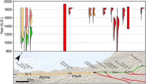
Figure 9. Space and time diagram summarising paleoearthquake data for the onshore and nearshore extent of the Alpine Fault. Red age probability density functions (PDFs) are on-fault records, yellow PDFs are MM 9 shaking events from fault-proximal lakes, grey PDFs are from fault-adjacent wetland records (not all depicted on this figure because of space constraints) and blue are from marine turbidites. Data sources as referenced in text above.
Discussion
One of the most obvious advances in Alpine Fault paleoseismology in the decade since Sutherland et al.’s (Citation2007) review is the number of past earthquakes we now know about. In 2007, evidence was discussed for three past earthquakes (Sutherland et al. Citation2007). In 2018, we have evidence for up to seven earthquakes replicated at multiple sites and a record of 27 earthquakes for one part of the fault (). Development and application of high-resolution paleoenvironmental reconstruction techniques has enabled the paleoseismic potential of long sedimentary archives to be utilised for the Alpine Fault. For example, the use of modern analogue earthquakes to inform the depositional model of lacustrine sediments (e.g. Howarth et al. Citation2012), the use of diatom microfossils to enhance interpretation of fault-adjacent wetland sequences (Clark et al. Citation2013) and the application of criteria developed for subduction earthquake paleoseismology to differentiate between coseismic and aseismic events (Cochran et al. Citation2017) are just a few of the strategies that have enabled development of longer Alpine Fault earthquake records. Undoubtedly, the most significant technical advance has been high-resolution radiocarbon dating, and age analysis using Bayesian statistical techniques. The ability to date paleoearthquakes to within a decade or two of their occurrence enables earthquake recurrence behaviour to be reliably assessed at a single site and correlation between sites can be undertaken in a statistically robust manner considering reasonable uncertainties rather than broad correlations based on overlap at centennial-scales and poorly quantified uncertainties. Without the recent improvements in radiocarbon precision, even the most explicit sedimentary records of earthquakes would not have provided us with the insights into earthquake recurrence behaviour, rupture extent and impacts we now have.
Improvements in our understanding of the Alpine Fault’s paleoseismic behaviour advanced by long earthquake records at multiple sites and like-for-like comparison of ages from on-fault and off-fault records are numerous (). Beginning in the most recent past, we can see that for the North Westland section of the Alpine Fault there is potential evidence for ruptures younger than the AD 1717 earthquake. Evidence for the AD 1717 earthquake has been strengthened by lake records of MM 9 shaking along the whole Central section of the fault at this time (Howarth et al. Citation2016) and the extent of evidence now indicating this was a great earthquake estimated at MW 8.1 ± 0.1 (De Pascale and Langridge Citation2012). Evidence is building against the AD 1620 event being a rupture of the Alpine Fault – there is no evidence for rupture of the Central section during this event, on-fault evidence for it further north is weak, and landscape disturbance records could be a sedimentary response to non-Alpine Fault forcing. The two extensive earthquakes prior to the AD 1717 event (at approximately AD 1400 and approximately AD 1150) appear to have been similar to AD 1717 in that they ruptured both the Central and South Westland sections of the fault. However, further back in time there are terminations of earthquakes at the boundary between the Central and South Westland sections so not every earthquake was similar to the AD 1717 great earthquake. There is also consistency between the number of high-intensity shaking events represented by marine turbidites from George Basin and the fault-adjacent wetland records of earthquakes from John O’Groats River (Barnes et al. Citation2013). Although the low resolution of marine turbidite ages precludes detailed correlations, the consistency in event numbers supports continuity of rupture along much of the South Westland section during at least the last seven ruptures on this part of the fault.
Beyond examining individual past earthquakes, we now have robust estimates of recurrence interval, coefficient of variation and conditional probabilities for some sections of the fault (). We see that surface-rupturing earthquakes occur remarkably regularly on the South Westland section of the fault (Berryman, Cochran et al. Citation2012). We are starting to understand that each section behaves differently and hence that differently sized earthquakes occur on this fault (Howarth et al., Citation2016). We have evidence for substantial landscape responses to Alpine Fault earthquakes with periods of increased sediment flux lasting up to 50 yr (Howarth et al. Citation2014). For the South Westland section of the fault, the likelihood of a surface-rupturing earthquake occurring in the next 50 yr is 29%. This is at the high end of previous seismic hazard estimates (Rhoades and Van Dissen Citation2003; Sutherland et al. Citation2006) but is now based on 27 past earthquakes instead of three. It is in part the large number of past earthquakes we now have evidence for – demonstrating that the next event is inevitable – that has motivated additional effort to prepare for the next Alpine Fault earthquake, for example through initiatives such as the AF8 project (Orchiston et al. Citation2018).
As well as illustrating the numerous improvements to the earthquake record for the Alpine Fault over the last few decades, also highlights the extensive gaps that remain. These gaps are important targets for future research. The North Westland section of the fault has the least well-constrained MRE, recurrence interval and rupture length. Approaches to radiocarbon dating of trench stratigraphy need improvement to refine age estimates from on-fault evidence and the near-fault lake records may help in determining the relatively complex rupture history that is beginning to emerge for the North Westland section. There are spatial gaps where no fault-proximal lakes exist, but fault-adjacent wetlands may have a role to play. At all the near-fault lake sites, the length of lake records was constrained by coring technique – it is possible, for example with involvement of the International Continental Drilling Programme, that these records could be extended back to 17 kyr. Slip rates and single event displacements are currently defined by relatively few sites. Further work on these would help to elucidate past activity on the fault and would be facilitated by continued acquisition of high-resolution topographic data sets from LiDAR to aid in the identification of offset landforms along the length of the fault (Langridge et al. Citation2014). Better understanding of sources of catchment disturbance other than Alpine Fault earthquakes may help to untangle some of the landscape disturbance records across the region ().
Figure 10. Illustration of the geological and geomorphic impacts of an Alpine Fault earthquake with regard to the timeframe over which various paleoseismic proxies record the earthquake.
The range of paleoseismological techniques that have been successfully applied to this fault strengthens our ability to develop strategies for future research (). Studies reviewed in this paper each have advantages and disadvantages – perhaps we can best answer remaining questions by combining their strengths. For example, tree ring suppressions provide the best age control for recent events but are unlikely to be useful for older earthquakes unless fossilised trees are found. Stratigraphy in trenches across the fault provides unequivocal evidence for surface-rupturing earthquakes but sediments do not always contain suitable material for dating. Lake records contain the most continuous record of sedimentation, enable high-resolution age control, shaking estimates and evidence of the landscape response to earthquakes. However, suitable lakes are not necessarily perfectly positioned along the fault. Fault-adjacent wetland records are more uniquely tied to the fault source than the lake records, but sedimentation is not as continuous. Landscape disturbance records such as forest disturbance, landsliding, river aggradation and dune formation can provide good estimates of the areal extent of damage but can be produced by non-seismic events such as storms. We show that these records are more likely to record the timing of post-seismic landscape stabilisation than the earthquake itself, so they may be best used for this purpose in future ().
From Wellman’s first recognition of the 480 km of offset > 75 yr ago, to the development of high-resolution long earthquake records over the last decade, paleoseismology has contributed enormously to our understanding of how this transform plate boundary fault operates and the hazard it poses to society. Insights likely to be drawn from future paleoseismology on the Alpine Fault include earthquake recurrence behaviour and forecasts for each section of the fault, the nature of boundaries to fault rupture, rupture extent for a larger sample of paleoearthquakes, the role that fault interaction plays in driving earthquake behaviour, and further detail about the long-term impacts of Alpine Fault earthquakes.
Acknowledgements
The authors would like to thank all the researchers who have contributed to a better understanding of Alpine Fault paleoseismology. The authors thank Nicolas Barth and Mark Stirling for constructive feedback that greatly increased the clarity and focus of the manuscript.
Disclosure statement
No potential conflict of interest was reported by the authors.
Additional information
Funding
References
- Adams J. 1980. Paleoseismicity of the Alpine Fault seismic gap, New Zealand. Geology. 8:72–76. doi: 10.1130/0091-7613(1980)8<72:POTAFS>2.0.CO;2
- Barnes PM. 2009. Postglacial (after 20 ka) dextral slip rate of the offshore Alpine Fault, New Zealand. Geology. 37(1):3–6. doi: 10.1130/G24764A.1
- Barnes PM, Pondard N. 2010. Derivation of direct on-fault submarine paleoearthquake records from high-resolution seismic reflection profiles: Wairau Fault, New Zealand. Geochemistry, Geophysics, Geosystems. 11(11):Q11013. doi: 10.1029/2010GC003254
- Barnes PM, Sutherland R, Delteil J. 2005. Strike-slip structure and sedimentary basins of the southern Alpine Fault, Fiordland, New Zealand. Geological Society of America Bulletin. 117(3-4):411–435. doi: 10.1130/B25458.1
- Barnes PM, Bostock HC, Neil HL, Strachan LJ, Gosling M. 2013. A 2300-year Paleoearthquake record of the southern Alpine Fault and Fiordland subduction zone, New Zealand, based on stacked turbidites. Bulletin of the Seismological Society of America. 103(4):2424–2446. doi: 10.1785/0120120314
- Barth NC, Boulton C, Carpenter BM, Batt GE, Toy VG. 2013. Slip localization on the southern Alpine Fault, New Zealand. Tectonics. 32:620–640. doi: 10.1002/tect.20041
- Barth NC, Kulhanek DK, Beu AG, Murray-Wallace CV, Hayward BW, Mildenhall DC, Lee DE. 2014. New c.270 kyr strike-slip and uplift rates for the southern Alpine Fault and implications for the New Zealand plate boundary. Journal of Structural Geology. 64:39–52. doi: 10.1016/j.jsg.2013.08.009
- Berryman KR, Beanland S, Cooper AF, Cutten HN, Norris RJ, Wood PR 1992. The Alpine Fault, New Zealand: variation in Quaternary structural style and geomorphic expression. Annales Tectonicae Supplement to 6(Special Issue): 126–163.
- Berryman KR, Cochran UA, Clark KJ, Biasi GP, Langridge RM, Villamor P. 2012. Major earthquakes occur regularly on an isolated plate boundary fault. Science. 336(6089):1690–1693. doi: 10.1126/science.1218959
- Berryman KR, Cooper A, Norris R, Villamor P, Sutherland R, Wright T, Schermer E, Langridge R, Biasi G. 2012. Late Holocene rupture history of the Alpine Fault in south Westland, New Zealand. Bulletin of the Seismological Society of America. 102(2):620–638. doi: 10.1785/0120110177
- Bronk-Ramsey C. 2001. Development of the radiocarbon calibration program Oxcal. Radiocarbon. 43(2A):355–363. doi: 10.1017/S0033822200038212
- Bull WB. 1996. Prehistoric earthquakes on the Alpine Fault, New Zealand. Journal of Geophysical Research: Solid Earth. 101(B3):6037–6050. doi: 10.1029/95JB03062
- Clark KJ, Cochran UA, Berryman KR, Biasi G, Langridge R, Villamor P, Bartholomew T, Litchfield N, Pantosti D, Marco S, et al. 2013. Deriving a long paleoseismic record from a shallow-water Holocene basin next to the Alpine Fault, New Zealand. Geological Society of America Bulletin 125(5–6): 811–832. doi: 10.1130/B30693.1
- Cochran UA, Clark KJ, Howarth JD, Biasi GP, Langridge RM, Villamor P, Berryman KR, Vandergoes MJ. 2017. A plate boundary earthquake record from a wetland adjacent to the Alpine Fault in New Zealand refines seismic hazard estimates. Earth and Planetary Science Letters. 464:175–188. doi: 10.1016/j.epsl.2017.02.026
- Cooper AF, Norris RJ. 1990. Estimates for the timing of the last coseismic displacement on the Alpine Fault, northern Fiordland, New Zealand. New Zealand Journal of Geology and Geophysics. 33(2):303–307. doi: 10.1080/00288306.1990.10425688
- Cox SC, Stirling MW, Herman F, Gerstenberger M, Ristau J. 2012. Potentially active faults in the rapidly eroding landscape adjacent to the Alpine Fault, central Southern Alps, New Zealand. Tectonics 31(2): n/a-n/a. doi: 10.1029/2011TC003038
- Croissant T, Lague D, Steer P, Davy P. 2017. Rapid post-seismic landslide evacuation boosted by dynamic river width. Nature Geoscience. 10:680–684. doi: 10.1038/ngeo3005
- Cullen LE, Duncan RP, Wells A, Stewart GH. 2003. Floodplain and regional scale variation in earthquake effects on forests, Westland, New Zealand. Journal of the Royal Society of New Zealand. 33(4):693–701. doi: 10.1080/03014223.2003.9517753
- De Pascale GP, Langridge RM. 2012. New on-fault evidence for a great earthquake in A.D. 1717, central Alpine Fault, New Zealand. Geology. 40:791–794. doi: 10.1130/G33363.1
- De Pascale GP, Quigley MC, Davies TRH 2014. Lidar reveals uniform Alpine fault offsets and bimodal plate boundary rupture behavior, New Zealand. Geology. 42(5):411–414. doi: 10.1130/G35100.1
- Duncan RP. 1989. An evaluation of errors in tree age estimates based on increment cores in kahikatea (Dacrycarpus Dacrydioides). New Zealand Natural Sciences. 16:31–37.
- Goldfinger C. 2011. Submarine Paleoseismology Based on Turbidite Records. Annual Review of Marine Science. 3(1):35–66. doi: 10.1146/annurev-marine-120709-142852
- Goldfinger C, Morey AE, Nelson CH, Gutierrez-Pastor J, Johnson JE, Karabanov E, Chaytor J, Eriksson A, Shipboard Sci P. 2007. Rupture lengths and temporal history of significant earthquakes on the offshore and north coast segments of the Northern San Andreas Fault based on turbidite stratigraphy. Earth and Planetary Science Letters. 254(1-2):9–27. doi: 10.1016/j.epsl.2006.11.017
- Hogg AG, Hua Q, Blackwell PG, Niu M, Buck CE, Guilderson TP, Heaton TJ, Palmer JG, Reimer PJ, Reimer RW, et al. 2013. SHCal13 southern hemisphere calibration, 0–50,000 years cal BP. Radiocarbon. 55(4):1889–1903. doi: 10.2458/azu_js_rc.55.16783
- Howarth JD, Fitzsimons SJ, Norris RJ, Jacobsen GE. 2012. Lake sediments record cycles of sediment flux driven by large earthquakes on the Alpine Fault, New Zealand. Geology. 40(12):1091–1094. doi: 10.1130/G33486.1
- Howarth JD, Fitzsimons SJ, Norris RJ, Jacobsen GE. 2014. Lake sediments record high intensity shaking that provides insight into the location and rupture length of large earthquakes on the Alpine Fault, New Zealand. Earth and Planetary Science Letters. 403:340–351. doi: 10.1016/j.epsl.2014.07.008
- Howarth JD, Fitzsimons SJ, Norris RJ, Langridge R, Vandergoes MJ. 2016. A 2000yr rupture history for the alpine fault derived from lake Ellery, south island, New Zealand. Geological Society of America Bulletin. 128(3-4):627–643. doi: 10.1130/B31300.1
- Hull AG, Berryman KR. 1986. Holocene tectonism in the region of the Alpine Fault at Lake McKerrow, Fiordland, New Zealand. Recent Crustal Movements of the Pacific Region. 24:317–331.
- Langridge RM, Basili R, Basher L, Wells AP. 2012. Late Holocene landscape change history related to the Alpine Fault determined from drowned forests in lake Poerua, Westland, New Zealand. Natural Hazards and Earth System Science. 12:2051–2064. doi: 10.5194/nhess-12-2051-2012
- Langridge RM, Ries WF, Dolan JF, Schermer ER, Siddoway C. 2017. Slip rate estimates and slip gradient for the Alpine Fault at calf paddock, Maruia river, New Zealand. New Zealand Journal of Geology and Geophysics. 60(2):73–88. doi: 10.1080/00288306.2016.1275707
- Langridge RM, Villamor P, Basili R, Almond P, Martinez-Diaz JJ, Canora C. 2010. Revised slip rates for the Alpine Fault at inchbonnie: implications for plate boundary kinematics of south island, New Zealand. Lithosphere. 2: 139–152. doi: 10.1130/L88.1
- Langridge RM, Ries WF, Farrier T, Barth NC, Khajavi N, de Pascale GP. 2014. Developing sub 5-m LiDAR DEMs for forested sections of the Alpine and hope faults, south island, New Zealand: implications for structural interpretations. Journal of Structural Geology. 64:53–66. doi: 10.1016/j.jsg.2013.11.007
- McCalpin JP, Nelson AR. 2009. Introduction to Paleoseismology. In: McCalpin JP, editor. Paleoseismology. 2nd ed. London: Elsevier; p. 1–27.
- McCalpin JP, Rockwell TK, Weldon Ii RJ, James PM. 2009. Chapter 6 Paleoseismology of strike-slip tectonic environments. Cambridge, MA: International Geophysics, Academic Press; p. 421–496.
- Norris RJ, Cooper AF. 2001. Late Quaternary slip rates and slip partitioning on the Alpine Fault, New Zealand. Journal of Structural Geology. 23(2):507–520. doi: 10.1016/S0191-8141(00)00122-X
- Norris RJ, Cooper AF. 2007. The Alpine Fault, New Zealand: surface geology and field relationships. In: Okaya D, Stern T, Davey F, editor. A continental plate boundary: tectonics at south island, New Zealand. Washington: American Geophysical Union; p. 159–175.
- Orchiston C, Mitchell J, Wilson T, Langridge R, Davies T, Bradley B, Johnston D, Davies A, Becker J, McKay A. 2018. Project AF8: developing a coordinated, multi-agency response plan for a future great Alpine Fault earthquake. New Zealand Journal of Geology and Geophysics. doi:10.1080/00288306.2018.1455716.
- Osborn G, McCarthy D, LaBrie A, Burke R. 2015. Lichenometric dating: Science or pseudo-science? Quaternary Research. 83(1):1–12. doi: 10.1016/j.yqres.2014.09.006
- Rhoades DA, Van Dissen RJ. 2003. Estimates of the time-varying hazard of rupture of the Alpine Fault, New Zealand, allowing for uncertainties. New Zealand Journal of Geology and Geophysics. 46:479–488. doi: 10.1080/00288306.2003.9515023
- Stewart GH, White JC. 1995. Tree ring analysis in rimu (Dacrydium cupressinum): implications for studies of forest dynamics and sustained yield management. New Zealand Forestry. 40:27–31.
- Sutherland R, Berryman KR, Norris RJ. 2006. Quaternary slip rate and geomorphology of the Alpine Fault: implications for kinematics and seismic hazard in southwest New Zealand. Geological Society of America Bulletin. 118(3/4):464–474. doi: 10.1130/B25627.1
- Sutherland R, Eberhart-Phillips D, Harris RA, Stern T, Beavan J, Ellis S, Henrys S, Cox S, Norris RJ, Berryman KR, et al. 2007. Do great earthquakes occur on the Alpine Fault in central south island, New Zealand? In: Okaya D, Stern T, Davey F, editor. A continental plate boundary: tectonics at south island, New Zealand. Washington: American Geophysical Union; p. 235–251.
- Tonkin PJ and Basher LR. 1990. Soil-stratigraphic techniques in the study of soil and landform evolution across the Southern AIps, New Zealand. In: Knuepfer PLK, LD McFadden, editors. Soils and Landscape Evolution. Geomorphology. 3:547–575.
- Wang J, Jin Z, Hilton RG, Zhang F, Densmore AL, Li G, Joshua West A. 2015. Controls on fluvial evacuation of sediment from earthquake-triggered landslides. Geology. 43(2):115–118. doi: 10.1130/G36157.1
- Wallace LM, Beavan J, McCaffrey R, Berryman K, Denys P. 2007. Balancing the plate motion budget in the south island, New Zealand using GPS, geological and seismological data. Geophysical Journal International. 168:332–352. doi: 10.1111/j.1365-246X.2006.03183.x
- Wellman HW, Willett RW. 1942. The geology of the west coast from abut head to Milford sound - part 1. Transactions of the Royal Society of New Zealand. 71:282–306.
- Wells A, Duncan RP, Stewart GH. 2001. Forest dynamics in Westland, New Zealand: The importance of large, infrequent earthquake-induced disturbance. Journal of Ecology. 89:1006–1018. doi: 10.1111/j.1365-2745.2001.00594.x
- Wells A, Goff J. 2006. Coastal dune ridge systems as chronological markers of palaeoseismic activity: a 650-yr record from southwest New Zealand. The Holocene. 16(4):543–550. doi: 10.1191/0959683606hl949rp
- Wells A, Goff J. 2007. Coastal dunes in westland, New Zealand, provide a record of paleoseismic activity on the Alpine Fault. Geology. 35(8):731–734. doi: 10.1130/G23554A.1
- Wells A, Stewart GH, Duncan RP. 1998. Evidence of widespread, synchronous, disturbance-initiated forest establishment in Westland, New Zealand. Journal of the Royal Society of New Zealand. 28(2):333–345. doi: 10.1080/03014223.1998.9517569
- Wells A, Yetton MD, Duncan RP, Stewart GH. 1999. Prehistoric dates of the most recent Alpine Fault earthquakes, New Zealand. Geology. 27(11):995–998. doi: 10.1130/0091-7613(1999)027<0995:PDOTMR>2.3.CO;2
- Yetton MD. 1998. Progress in understanding the paleoseismicity of the central and northern Alpine Fault, Westland, New Zealand. New Zealand Journal of Geology and Geophysics. 41:475–483. doi: 10.1080/00288306.1998.9514824
- Yetton MD. 2002. Paleoseismic investigation of the north and west Wairau sections of the Alpine Fault, South Island, New Zealand. EQC Research Report 99/353.
- Yetton MD, Wells A, editor 2010. Earthquake rupture history of the Alpine Fault over the last 500 years. London, Taylor and Francis Group.
- Yetton MD, Wells A, Traylen, NJ. 1998. The probabilities and consequences of the next Alpine Fault earthquake. EQC Research Report 95/193.
- Zachariasen J, Berryman K, Langridge R, Prentice C, Rymer M, Stirling M, Villamor P. 2006. Timing of late Holocene surface rupture of the Wairau Fault, Marlborough, New Zealand. New Zealand Journal of Geology and Geophysics. 49(1):159–174. doi: 10.1080/00288306.2006.9515156