
ABSTRACT
This paper provides new maps of the surficial sediment distribution on the continental shelf (0∼150 m water depth) of New Zealand based on a new database – nzSEABED. The maps of percent mud, sand, gravel and carbonate, are compared with previous research to provide a comprehensive update of the surficial sediment distributions on the continental shelf, together with a review of the main environmental (oceanographic and climatic), geomorphological and geological processes and human activities that have influenced sediment deposition. Continental shelves are dynamic regions that are in a constant state of flux from floods, storms, tides, waves, earthquakes and volcanic activity. While some of these events may be captured by individual samples, the compilation of >23,000 samples collected and analysed over 60 years provides a long-term average distribution of sediments on the continental shelf that can inform future research and coastal management.
Introduction
The current study is Part B of two-companion papers that reviews and updates the distribution of surficial-marine sediment around New Zealand. Part A deals with the open ocean systems of the slope and deep basins within the New Zealand exclusive economic zone (EEZ) and extended continental shelf (ECS). It also summarises the history of sediment collection and previous maps, along with the main methods that were used in this study and the sediment distributions in the open ocean. Here, in Part B, we focus on the grainsize and carbonate content of the continental shelf around New Zealand, (defined as a near flat plain that descends from the shore to the shelf edge which averages at 130 m water depth, but may be as deep as 250 m), comparing them to our current knowledge of the environmental parameters such as: terrigenous fluxes, tectonic and volcanic influences, oceanographic currents, waves, tides and storms and human influences. This paper builds on the partially completed New Zealand coastal sediment chart series (Part A; and ) and updates a previous overview of marine sediments around the New Zealand continental ‘terrace’, undertaken by Carter (Citation1975) and its sister publication where these sediment patterns were interpreted in concert with knowledge of the oceanographic currents, waves, tides and storms at that time (Carter and Heath Citation1975), and a subsequent review of coastal oceanography by Hume et al. (Citation1992). Understanding the surficial sediment distribution of the continental shelf will aid with the management and protection of New Zealand's marine realm, by providing information about the physical character of the seabed, helping to determine biological habitats, favourable places to locate offshore marine infrastructure, as well as potential resources (e.g. sand and gravel, ironsands).
Table 1. Characterisation of the continental shelf sediments for each region and the dominant processes influencing sediment transport.
Data and methods
The main methods used in this paper are briefly summarised below; we refer the reader to Part A for more detailed methods. More than 30,000 surface sediment data from the New Zealand Oceanographic Institute (NZOI, now the National Institute of Water and Atmospheric Research (NIWA)) and other international databases within the New Zealand Exclusive Economic Zone (EEZ) and extended continental shelf (ECS) were integrated using the dbSEABED software tools (see Jenkins et al. Citation2008), to generate a new database – nzSEABED. The coverage of the surface sediment samples around the New Zealand region is highly variable (See Part A: B). Approximately 76% (∼23,000) of these samples were collected on the continental shelf from water depths <150 m (A, B). Sample density is patchy, and more concentrated in regions where previous sediment charts were produced (Part A; , ) and in regions of high scientific interest, such as the Hawke Bay shelf (Pantin Citation1966), Canterbury shelf (Herzer Citation1977) and Cook Strait (Carter Citation1992; Lucieer and Lamarche Citation2011). The database was imported in to ArcGIS and we used the ordinary kriging method to interpolate between the data-points on a 1 × 1 km grid. The predicted standard error (standard deviation for any point) for percent mud for the kriging interpolation is low in well sampled regions such as the continental shelf (8–16%). We have not used other environmental parameters to enhance the interpolation as we found no correlation between grainsize and bathymetry and water depth, or current oceanographic conditions as some regions display relict sediments (sediments deposited under different conditions >7000 yrs ago). Several caveats should be noted; that we have not included rocks in this database, thus the interpolated sediments will superimpose over rock outcrops; and the traditional methods for sampling sediments struggle to admit shell, pebble and cobbles (Ferguson and Paola Citation1997) and thus the methods are inherently biased against these larger grainsizes. Thus gravel percent may be less reliable than the mud and sand percent.
Figure 1. Map of New Zealand with the sediment stations included in nzSEABED. A) North Island, B) South Island. Isobaths are shown at 50 m, 100 m, 150 m and 200 m (also 500 m, 1000 m, 2000 m and 3000 m). The edge of the continental shelf is shown in a dashed pink line. The area shaded light brown was exposed when sea level was -120 m during the last glacial. The main ocean currents are shown in blue and labelled: EAUC – East Auckland Current, ECC – East Cape Current, WCC – Wairarapa Coastal Current, SC – Southland Current, WC – Westland Current, DUC – D’Urville Current. The strong tidal currents in Cook Strait and Foveaux Strait are shown by a double-headed arrow.
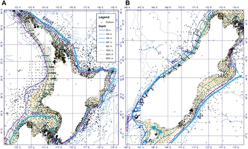
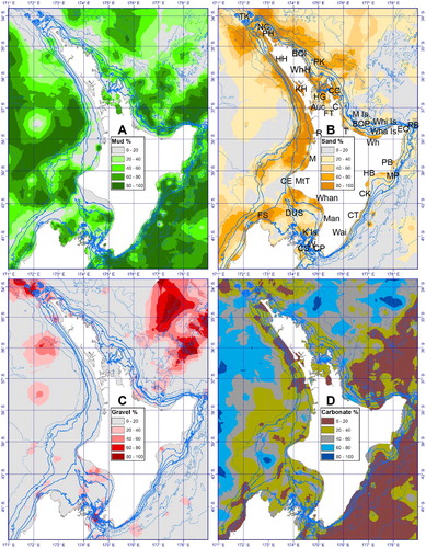
Figure 2. Map of the surficial sediments of the North Island continental shelf. A) Mud %, B) Sand %, C) Gravel %; D) Carbonate %. We have used the dbSEABED colour legends for the representation of the different sediment properties (http://instaar.colorado.edu/~jenkinsc/dbseabed/helpful/index.html). Station locations are not shown as they obscure the information in regions that are densely sampled. Place names are labelled: TK – Three Kings, NC – North Cape, PH – Parengarenga Harbour, BOI – Bay of Islands, PK – Poor Knights Islands, WhH – Whangarei Harbour, Auc – Auckland, HG – Hauraki Gulf/Tīkapa Moana, FT – Firth of Thames, CC – Colville Channel, C – Coromandel, BOP – Bay of Plenty, T – Tauranga, Wh – Whakatane, M Is. – Mayor Island, Wha Is. – Moutohora/Whale Island, Whi Is. – Whakaari/White Island, EC – East Cape, RB – Ranfurly Bank, MP – Mahia Peninsular, PB – Poverty Bay/Turanganui-a-Kiwa, HB – Hawke Bay, CK – Cape Kidnappers, Cape Turnagain, Wai – Wairarapa, KH – Kaipara Harbour, HH – Hokianga Harbour, R – Raglan, M – Mokau, MtT – Mt Taranaki, CE – Cape Egmont, FS – Farewell Spit, Whan – Whanganui, Man – Manawatu, K Is. – Kapiti Island, DUS – D’Urville Seavalley, W – Wellington, CP – Cape Palliser.
The distribution of surface sediment grainsize/texture (percent mud, sand and gravel = total 100%) and carbonate contents (CaCO3 percent, versus non-carbonate material (not shown) = total 100%) from the nzSEABED database are presented geospatially as maps to show the large scale spatial patterns on the continental shelves of the North Island () and South Island ().The carbonate content provides information about the amount of biological material produced in the water column by plankton, or on the seafloor by marine organisms and is typically carbonate-rich. The inverse non-carbonate component it primarily derived from the land, termed terrigenous material, due to reworking by wind and water (rainfall and rivers) into the oceans. Authigenic minerals are also present in some regions, these are precipitated at the sea floor, under specific environmental conditions and typically over long periods of time and on the continental shelf are usually glauconite. The sediments are also referred to as modern, which indicates that they have been deposited under modern (interglacial) environmental conditions over the last ∼7000 years when sea level (Clement et al. Citation2016) and ocean currents have been similar to today. In other regions sediments are referred to as relict, which implies they were deposited >7000 years ago when sea level was lower and or other environmental conditions were different. Sea level fluctuates over glacial/interglacial cycles due to changes in the global ice volume. During the last glacial at ∼20,000 years ago, sea level was ∼120 m lower than the present (Lambeck et al. Citation2014) and vast areas of the continental shelf were exposed (), or very shallow and influenced by waves and storms. These nzSEABED maps, therefore, plot each component of texture (percent mud, sand and gravel) and carbonate (percent calcium carbonate) independently, in contrast to the previous NZOI-NIWA coastal sediment charts, which used a ternary and hierarchical sediment classification approach (e.g. Folk Citation1954; Folk et al. Citation1970), combining textural information with carbonate data. For example, some regions of the coastal charts are colour- and pattern-coded as ‘calcareous-gravelly sandy mud’ (e.g. Cook Strait Sediment Chart, Lewis and Mitchell Citation1980), indicating that there is a polymodal distribution of sediment grainsizes, both gravel sand and mud, with the gravel dominated by (>50%) biogenic carbonate shell material. These historical coastal sediment charts, therefore, provide significantly more sediment textural information on one map. However, they can be complicated to interpret for non-specialists, especially as each chart was completed by different individuals and used different classifications and nomenclature i.e. compare the classification scheme used for the 1966 Foveaux chart (Cullen and Gibb Citation1965) with the last coastal sediment chart published by NZOI-NIWA (Patea Sediment Chart, Nodder et al. Citation1992). The new nzSEABED provides a seamless and consistent dataset of the surficial sediments on the entire continental shelf of the North and South islands of New Zealand for use by other researchers and policy makers. To this end we have included a glossary of some of the sedimentological terms that may not be familiar for a more general audience. It should also be noted that all locations referred to in the text are official or recognised unofficial names according to the New Zealand gazetteer (https://gazetteer.linz.govt.nz/).
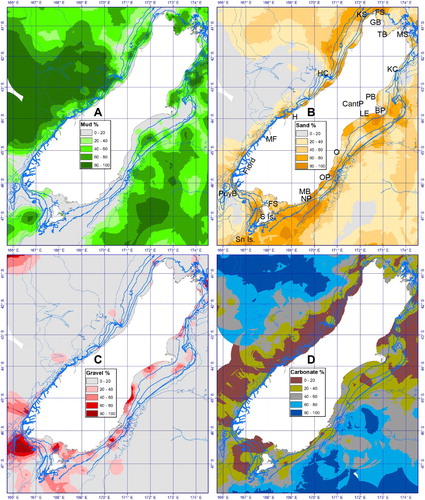
Figure 3. Map of the surficial sediments of the South Island continental shelf. A) Mud %, B) Sand %, C) Gravel %, D) Carbonate %. Station locations are not shown as they obscure the information in regions that are densely sampled. Place names are labelled: KC – Kaikoura Canyon, CantP – Canterbury Plain, PB – Pegasus Bay, BP – Banks Peninsula, LE – Lake Ellesmere, O – Oamaru, OP – Otago Peninsula, MB – Molyneux Bay, NP – Nugget Point, FS – Foveaux Strait, S Is. – Stewart Island, Sn Is. – Snares Islands/Tini Heke, PuyB – Puysegur Bank, Fiord – Fiordland, MF – Milford Sound, HC – Hokitika Canyon, KS – Kahurangi Shoals, FS – Farewell Spit, GB – Golden Bay, TB – Tasman Bay.
Continental shelf surficial sediments
The definition of the continental shelf is a near-flat plain that descends from shore to the shelf edge, where the seabed then descends more steeply to form the continental slope (IHO Citation2008; Harris et al. Citation2014). Around New Zealand, the edge of the continental shelf is typically ∼130 m below sea level, but can be as deep as 200 m off Hawke Bay and 250 m off Taranaki-Manawatu. The shelf width varies considerably around New Zealand from just a few kilometres off Fiordland and Kaikoura, to more than 160 km wide in the Taranaki Region. The shelf edge can be curvilinear, but in some regions it is irregular due to incisions by submarine canyons or landslides (e.g. Cook Strait, the East Coast North Island, the West Coast South Island, and Otago).
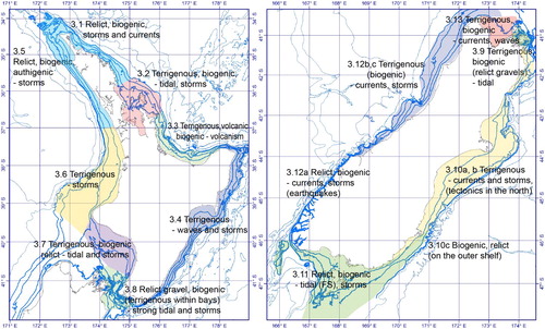
In the presentation of the results below the continental shelf surficial sediments are discussed by region with accompanying texture and carbonate maps (; and Supplementary Figures). The new maps are discussed and compared to previous sedimentological work undertaken in the area and related to the local influx of terrigenous sediments via rivers, volcanic and tectonic influences, and the regional hydrodynamic regime (waves, tides, currents, as recently reviewed by Stevens et al., submitted). The dominant sediment and drivers for each region are summarised in and .
Figure 4. Summary of the dominant sediments in each region and the main environmental and geological factors influencing the distribution of the sediments. See for more details. Numbers refer to the sections in the paper that discuss the regions.
East Coast Northland
The Three Kings region sits at the northernmost tip of Northland and projects out into the Tasman Sea. No detailed coastal sediment charts have previously been made of this region, although a larger chart was (McDougall Citation1979). The sediments in this region have low mud percent (<20%; A; S1A), with this region dominated by sand and gravel (B; 2C; S1B; S1C). The carbonate content is variable ranging from 0–80% (D; S1D), and some of the gravel around the coast is volcanic, eroded from the local headlands (Cryer et al. Citation2000). The sediments in this region are affected by high energy subtropical storms and waves; with strong tidal and current flows (0.5–2 m s−1) that redistribute the fine-grained sediments (Nelson et al. Citation1982; Cryer et al. Citation2000). This is the region where the Tasman Front, which transports subtropical water from the East Australian Current (EAC) eastwards across the Tasman Sea, re-attaches to the northern tip of New Zealand to form the East Auckland Current (EAUC; Stanton et al. Citation1997).
The EAUC flows down the east coast of Northland past Auckland with surface flows as strong as ∼0.6 m s−1 (Stanton et al. Citation1997), although, the strength and location of the core of the EAUC varies seasonally and interannually (Roemmich and Sutton Citation1998). The EAUC primarily bathes the edge of the continental shelf, but during Austral summer there are occasional incursions onto the shelf, initiated by strong southeasterly winds, potentially influencing biological productivity on the shelf (Sharples Citation1997; Sharples and Grieg Citation1998; Zeldis et al. Citation2004). Shelf tidal currents on the northeast shelf are low (0.05–0.1 m s−1; Sharples and Grieg Citation1998), although strong internal tides have been observed along this shelf (Sharples et al. Citation2001), with speeds of 0.3 m s−1 on the shelf around the Poor Knights Islands (Stevens et al. Citation2005). These internal tides are highly variable, but at these speeds they could potentially transport up to medium sand sized sediments on the shelf. Despite their potential vigour there have been no studies of sediment transport by internal waves on the continental shelf of New Zealand.
Along the east coast of Northland from North Cape to the Bay of Islands the muds are largely restricted to the inner shelf, but the mid- and outer shelf are dominated by sand (60–100%; B; S1B), with small amounts of gravel (0–60%; C; S1C). Apart from a small area off North Cape, the region becomes increasingly carbonate-rich to the south along the shelf (D; S1D). The low mud content for most of this region is not particularly surprising, as the numerous small catchment streams and rivers only deliver a total of 1.2 Mt y−1 of suspended sediments (mud and fine sand) to the entire northeast coast (Hicks and Shankar Citation2003; Hicks et al. Citation2011). The modern terrigenous sediments are primarily trapped in estuaries and harbours (Pickrill Citation1985) with small amounts being transported and deposited on the inner shelf, while the majority of the sediments on the mid- and outer shelf are considered relict (Summerhayes Citation1969; Carter Citation1975). Just offshore from the mouth of the Parengarenga Harbour, there are well-sorted, fine-grained sands that extend as far out as the mid-shelf (Summerhayes Citation1969). These clean, well-sorted, silica-rich (95%) sands are known as the ‘Parengarenga Sand Facies’ (Schofield Citation1970; Hayward et al. Citation2001). Their presence on the mid-shelf probably reflects a relict origin, derived from deposits formed during a period of lower sea-level (Carter and Heath Citation1975). These observations are supported by the common occurrence of glauconite in mid- to outer shelf sediments (Summerhayes Citation1969). This green mineral is formed by the marine diagenetic alteration (chemical break-down and alteration) of clays and micas under reducing conditions, and is considered diagnostic of depositional environments with slow rates of sediment accumulation (Bentor and Kastner Citation1965; McRae Citation1972; McConchie and Lewis Citation1980). Pockets of gravel (C; S1C) occur nearshore around headlands due to localised cliff erosion along this coast.
South of the Bay of Islands, the sand content on the shelf declines with increasing mud content (40–60%; A; S1A). The mud is sourced from the rivers flowing in to the Bay of Islands which have a total annual suspended sediment load of 0.6 Mt y−1 (Hicks and Shankar Citation2003). Muddy sand and sandy mud are the most dominant sediment types within the bay (Bostock et al. Citation2010). The muddy sediments are transported by the tidal currents from the bay out to the adjacent shelf (Pritchard et al. Citation2010). This is supported by compound specific isotopes on biomarkers which show that sediments from the Bay of Island river catchments are present on the adjacent shelf (Gibbs and Olsen Citation2010). The mud is then transported south by the EAUC, although a previous coastal sediment chart of the Poor Knights region (Eade Citation1974) shows little mud and the dominance of biogenic gravel immediately around the islands and headlands, suggesting that most of this mud is deposited upstream of the Poor Knights region. Or alternatively the strong internal tides in this region are resuspending the fine sediments, which continue to be transported south. South of Whangarei Harbour there is a small amount of mud nearshore (A; S1A), while sand dominates on the inner shelf (B; S1B).
Auckland-Hauraki Gulf/Tīkapa Moana
A coastal sediment chart of the Hauraki Gulf/Tīkapa Moana region was published by Carter and Eade (Citation1980). The outer Hauraki Gulf/Tīkapa Moana is dominated by sand and gravel (B; S1B), with small amounts of mud (A; S1A). This is due to the strong tidal currents between the islands of up to 0.8 m s−1 (Greig Citation1990), which winnow away the fine sediments to leave coarser carbonate debris/gravel (Manighetti and Carter Citation1999). Bathymetric mapping of this region also shows a series of sand waves of different orientations that are possibly relict (Manighetti and Carter Citation1999; Mackay et al. Citation2012). Carbonate contents in this region are moderate, ranging from 20–60% but reaching 80% in the outer Hauraki Gulf/Tīkapa Moana southwest of Great Barrier Island (Aotea Island) (D; S1D), where carbonate bivalve and bryozoan fragments prevail (Smith and Nelson Citation1994; Manighetti and Carter Citation1999). It has been suggested that the central Hauraki Gulf/Tīkapa Moana is a large depocentre of modern terrigenous sediment, contributed from the river run-off to the region, but also sediment transported shoreward from the outer shelf during large storm events (Manighetti and Carter Citation1999). However, this region may be just a conveyance zone as little sand sized sediment gets in to the Firth of Thames from the outer shelf, and most of it is transported offshore to the southeast through Colville Channel (Manighetti and Carter Citation1999).
Mud dominates in the inner Hauraki Gulf/Tīkapa Moana and Firth of Thames (80–100%; A; S1A). Previous studies have found that this region is characterised by sandy or calcareous gravelly muds (Carter and Eade Citation1980; Manighetti and Carter Citation1999), with very high organic matter, especially in the firth (Giles et al. Citation2007). The suspended sediment load of rivers in this region is 0.35 Mt y−1 (Hicks and Shankar Citation2003). While there are strong tidal currents in the outer Hauraki Gulf/Tīkapa Moana, the circulation in the Firth and Gulf responds predominantly to winds from the northwest or southeast (i.e. parallel to the coast; Proctor and Greig Citation1989; Zeldis et al. Citation2004). The inner Firth of Thames circulation is also strongly influenced by freshwater influx from the Waihou and Piako rivers (Zeldis et al. Citation2004).
Coromandel Peninsula-Bay of Plenty Region
The first compiled sediment map of the Bay of Plenty Region was produced by Doyle et al. (Citation1979). The map shows a sand-dominated coast, with small amounts of mud. The nzSEABED data shows there are moderate amounts of gravel (<40%) off Tauranga City, and associated with a patch reef just west of Whakatane (C; S2C). These reefs are also associated with moderate amounts of carbonate (D; S2D), but carbonate is generally low on the rest of the shelf. Detailed sampling by Longdill et al. (Citation2005, Citation2007) along the shelf displays a band of fine silty sand nearshore, interspersed with some cobble and patch reefs, some of which are associated with islands. A small patch of more sandy sediment is found at 100 m water depth off Whakatane (B, S2B). On the eastern side of the bay there is a large wedge of mud on the mid-outer shelf (A; S2A). Some of the fine muds show significant amounts of total organic matter (Longdill et al. Citation2005, Citation2007). This suggests that most of the fine sediment is likely sourced from the local rivers that flow into the bay, which contribute an average of 14 Mt y−1 of terrigenous suspended sediment to the region (Hicks and Shankar Citation2003). There is also a large amount of volcanic ash (tephra or ash flow deposits) and other volcanic products (lava flows, bombs, volcaniclastic flows) found in this region, with volcanic sediments especially dominant adjacent to volcanic edifices, such as Moutohora/Whale Island and Whakaari/White Island (Kohn and Glasby Citation1978; Propp et al. Citation1994).
Water movement within the Bay of Plenty is relatively minor with a general flow from west to east, dominated by the EAUC, which is found immediately off the shelf (Ridgway and Greig Citation1986). Longdill et al. (Citation2008) showed that the general surface circulation in the bay is strongly responsive to wind events, which are predominantly from the northwest, but are quite variable. Sediment transport and distribution, however, are predominantly influenced by large storms, which originate in the mid-latitudes (Tasman Sea) or from extratropical cyclones (Hay et al. Citation1991; Gibb Citation1997). The frequency and strength of these extratropical storms appear to be related to climate oscillations such as the El Niño Southern Oscillation (de Lange and Gibb Citation2000).
East coast North Island
Several charts have been published for the east coast of the North Island including Mahia Peninsula (Pantin and Gibb Citation1968) and Cape Turnagain (Lewis and Gibb Citation1970). The texture data from nzSEABED show the narrow continental shelf is dominated by mud (60–80%; especially along the northern edge of the East Cape; A; S2A), with only a small amount of sand and gravel (B; 2C; S2B; S2C). In contrast, there is a small patch of gravel, with high carbonate content immediately offshore from East Cape, associated with Ranfurly Bank (McDougall Citation1975).
The east coast North Island is part of the Hikurangi Subduction Margin and sedimentation along this coast is strongly controlled by active tectonics (Gerber et al. Citation2010). Active upper plate thrust faults breach the continental shelf along the length of the east coast and have formed discontinuous rocky outcrops along the length of the shelf (e.g. Ariel Bank; Lachlan Banks). These reefs influence modern sediment transport processes and commonly define the outer edge of sediment depocentres (Mountjoy and Barnes Citation2011).
On top or this tectonic control, the eastern region of the North Island has the highest suspended sediment discharge in New Zealand today with 69 Mt y−1 between East Cape and Mahia Peninsula (Hicks and Shankar Citation2003). The fluvial sediment load is dominated by three river catchments; in the north by the Waiapu (35 Mt y−1) just south of East Cape, the Uawa-Hikuwai (5 Mt y−1) in Tolaga Bay, and the Waipaoa (15 Mt y−1) that drains into Poverty Bay/Turanganui-a-Kiwa (Hicks and Shankar Citation2003). The high terrigenous loads in these rivers are due to the tectonic uplift and rapid weathering of highly erodible Tertiary mudstone- and sandstone-dominated catchment during severe storms (Hicks et al. Citation2000). Sediment discharge and shelf deposition increased significantly with human arrival and deforestation (Gomez et al. Citation2007). A considerable amount of work has been undertaken on the continental shelf and adjacent slope of Poverty Bay/Turanganui-a-Kiwa, immediately offshore of the Waipaoa River, through the US-NZ Margins Source to Sink programme (reviewed in Kuehl et al. Citation2016), and the shelf off East Cape and the Waiapu River (e.g. Ma et al. Citation2008, Citation2010; Kniskern et al. Citation2010). This work has shown that flood events deliver considerable quantities of sediment to the shelf, but these flood deposits are then reworked on the inner-shelf by waves and currents (and in gravity driven turbidity currents), which move the sediment in the nearshore bays out on to the shelf depocentres and beyond (Ma et al. Citation2008, Citation2010; Wadman and McNinch Citation2008; Kniskern et al. Citation2010; Bever et al. Citation2011). Wave heights average ∼1 m, although they can exceed 6 m during large storms (Orpin Citation2004).
Along the shelf, the relatively weak Wairarapa Coastal Current flows northwards, from Cape Palliser to Mahia Peninsula, although it is highly variable. Further offshore the East Cape Current flows southwards (Chiswell and Roemmich Citation1998; Chiswell Citation2002, Citation2005). Both these currents, reinforced by storm-forced water motions, result in northeast-ward alongshore transport as well as an across shelf transport of sediment (e.g. Stephens et al. Citation2001; Wood Citation2006; Hale et al. Citation2014).
Thus the long-term sediment accumulation on the Poverty Bay/Turanganui-a-Kiwa shelf is primarily driven by re-dispersal by oceanographic events (storms and currents) and gravity driven flows, rather than the initial flood-derived sediment delivery (Hale et al. Citation2014; Moriarty et al. Citation2015). Centennial accumulation rates reach a maximum of 1 cm y−1 on the outer shelf (Orpin et al. Citation2006; Gerber et al. Citation2010). Sediment dispersal over millennial time periods has trapped a thick, post-glacial mud deposit on the mid- and outermost shelf, with sediment depocentres reaching a maximum thickness of >45 m. However, half of the sediment from this dispersal system today, is lost to the wider margin, either advected offshore to the upper slope (Alexander et al. Citation2010), or redistributed northeast along the shelf through sediment reworking by combined current and wave activity (Hale et al. Citation2014).
Further south, the narrow continental shelf off Hawke Bay and along the Wairarapa coast are dominated by mud (20–100%; A; S3A) and sand (20–80%; B; S3B) with low concentrations of carbonate (0–40%; D; S3D). The terrigenous sediment flux into Hawke Bay is 11 Mt y−1 (Hicks and Shankar Citation2003). A detailed study of Hawke Bay showed that there was an inshore sand belt with two gravel zones in the centre of the bay and just north of Cape Kidnappers (Pantin Citation1966). There are additional patches of sand along the edge of the shelf, which extend down from the Mahia Peninsula, atop the Lachlan Ridge (Barnes and Nicol Citation2004; Paquet et al. Citation2009). The transition from sand to mud in the bay is related to increasing water depth and the decrease in wave power. However, this does not explain the presence of the sand and gravel patch in the centre of the bay and along Lachlan Ridge. These sand and gravel zones are considered to be relict due to the presence of glauconite, pebbles and exposed rock on the ridge (Pantin Citation1966; McDougall Citation1975). However, there must be sufficient bottom current or wave action to sweep these regions free from the accumulation of muddy sediments which dominates along the rest of this coast (Pantin Citation1966; Pickrill and Mitchell Citation1979).
The terrigenous sediment discharge along the Wairarapa coast is 3 Mt y−1 (Hicks and Shankar Citation2003). Here, the continental shelf is relatively narrow and the nearshore inner shelf is dominated by sand, which transitions to muddy sand on the outer shelf (A, 2B; S3A; S3B). There is one minor patch of gravel in the south and some evidence of glauconite in a couple of locations suggesting low sedimentation rates and only minor terrigenous flux, possibly due to the sediment transport being restricted by a ridge feature. The transition from sand on the inner shelf to mud on the outer shelf is likely controlled by wave grading on this exposed coast. Ocean swell at Cape Palliser are predominantly from the south and occasionally exceed 5 m during a large southwesterly storm (Pickrill and Mitchell Citation1979; Matthews Citation1980; Gorman et al. Citation2003).
West coast Northland
No detailed coastal sediment charts were previously made for this region, but a detailed study of this region was undertaken by Payne et al. (Citation2010). The nzSEABED maps display small amounts of mud (0–40%; A; S1A) on the nearshore inner shelf of the northwest shelf, but the inner, mid- and outer shelf of this region is dominated by sand (40–100%; B; S1B), with minor amounts of gravel as one heads further south (0–40%; C; S1C). High carbonate content (40–80%) is prevalent in the north and decreases (0–40%) in the central region, before increasing slightly towards the south (0–60%). The carbonate content in the north is mainly bryozoan fragments, most likely sourced locally and transported in from the Three Kings region at the northern tip of Northland (Nelson et al. Citation1982; section 3.1), while further south in shallow waters (<80 m) the carbonate is predominantly gastropods and molluscs (Payne et al. Citation2010). Sediments on the outer shelf of the Northland west coast are considered to be relict due to the high glauconite content, especially in the north (Payne et al. Citation2010). The terrigenous discharge to this coast is 2.9 Mt y−1 (Hicks and Shankar Citation2003), but the majority of this fluvial sourced sediment appears to be delivered to the coast via Kaipara and Hokianga harbours and is likely trapped in these expansive tidal embayments aided by the mangrove forests in some areas (Reeve et al. Citation2008). Thus the high glauconite content is the result of the paucity of modern terrigenous sediment on the shelf.
Low mud content on the continental shelf in this region is due to the prevailing southwesterly wind systems and high-energy storm waves (Carter Citation1975; Heath Citation1982, Citation1985; Nelson et al. Citation1988). These storms enhance the dominant alongshore current that flows northeast along the margin (Brodie Citation1960; Heath Citation1973; Stanton Citation1973; Sutton and Bowen Citation2011). Waves resuspend fine sediments and transport sand along the shelf (Schofield Citation1975) and offshore (Payne et al. Citation2010). Tidal currents on the open shelf of west Northland are weak (Stanton Citation1973) and unlikely to result in sediment transport per se, but reinforce the mean flow and storm-forced currents to affect transport.
West coast North Island-Northern Taranaki
Two coastal sediment charts were produced for the west coast region north of Taranaki: Raglan (Doyle and Arron Citation1982) and Mokau (Arron and Doyle Citation1983). The nzSEABED data show a similar trend in the sediment grainsize as the west coast of Northland, with a small amount of mud in the nearshore (<60%; A; Figure S4A) and then a sand-dominated mid-shelf (up to 80%; B; S4B), with increased gravel content (up to 40%; C; S4C).
Barotropic tidal currents on the Taranaki continental shelf are relatively weak with speeds of around 0.07 m s−1 (Stanton Citation1977), although internal tides may generate phase speeds of up to 0.3–0.5 m s−1 at the shelf edge (Proctor and Carter Citation1989). The barotropic tides do not transport sediment, but the potential influence of the internal tides on the sediment transport has not been studied. The prevailing westerly winds result in a wave-dominated coast with wave heights of 1–3 m and period of 6–9 s, which is sufficient to resuspend the sediment at the sea bed down to 40 m (Carter and Lewis Citation1995; Chiswell and Kibblewhite Citation2010). During storms, when winds can exceed 100 km h−1, large wave heights of 4–6 m have been measured and are able to rework sand down to depths of >70 m (Carter and Heath Citation1975; Lewis Citation1979; Pickrill and Mitchell Citation1979; Carter Citation1980; Gorman et al. Citation2003). The presence of abundant bedforms orientated orthogonal to the prevailing westerly swell (Orpin et al. Citation2009) suggests that waves and near-bed currents frequently transport coarse sand-sized detritus on the inner shelf.
There is also evidence for northward transport of sediments along this coast driven by the combination of the along shore current and storms (section 3.5). This is particularly evident from the distribution of ironsands on the continental shelf, which decrease in concentration northwards (Carter Citation1980). The ironsands are rich in titanomagnetite, sourced from Mt Taranaki and older volcanic centres (Christie Citation1975; Brathwaite et al. Citation2017), and are present on the inner and mid shelf in concentrations >5% as far north as Auckland (Carter Citation1980). Elsewhere, ironsand contents are lower (<2%), with a slight increase in concentrations immediately offshore river mouths such as the Mokau River (36%) and Waikato River (39%), due to new influxes of reworked ironsand from the land (Carter Citation1980). The rivers in this region deliver 4 Mt y−1 of suspended sediment onto the coast (Hicks and Shankar Citation2003), with an additional bedload of cobbles and pebbles prevalent nearshore in the southern section of this region (McDougall and Brodie Citation1967). Around the Taranaki peninsula, large areas of the seabed are covered in coarse gravel sediments from cobbles through to boulders. Diver observations indicate boulders in excess of 2 m in diameter that are volcanic in origin and related to reworking of lava flows from Mt Taranaki (Nodder Citation1995). In this southern section, just to the north of Taranaki there is also increased mud content on the mid-shelf (up to 100%; A; S4A), reduced sand content (<40%; B; S4B) and up to 60% gravel (C; S4C). This section of shelf is very wide (up to >160 km) and the outer shelf is up to 300 m deep (A; 2). The high mud and low sand content likely reflects the deeper depths in this zone, with lower current speeds, allowing the mud and fine sediments to settle out. There is a small area of the outer shelf with higher carbonate content (40–80%) (D; S4D). These carbonate sands and gravels are considered relict from previous lower sea-levels (McDougall and Brodie Citation1967; Carter and Heath Citation1975).
South Taranaki-Whanganui Bight and Manawatu-Kapiti
Sediment charts were compiled for the Patea area, south of Cape Egmont by Nodder et al. (Citation1992) and a significant amount of work has been done on the surface sediments and bedforms of the South Taranaki-Whanganui Bight region (e.g. Norris and Grant-Taylor Citation1989; Gillespie and Nelson Citation1996; Gillespie et al. Citation1998), especially as it has recently become the focal area for potential offshore ironsand extraction (Lewis Citation1979; Gillespie and Nelson Citation1996; Orpin et al. Citation2009; Brown Citation2013). South of Taranaki the sediment distribution on the inner shelf is dominated by sand (up to 80%; B; S5B) and gravel (up to 100%, especially offshore Whanganui; C; S5C). Further offshore on the mid-shelf there is slightly more mud (A; S5A), less sand (B; S5B), but still up to 40% gravel (C; S5C). The gravel is predominantly shelly carbonate material (bivalves, bryozoans) that is a mix of modern and relict shells. Volcanic pebbles are also common. The continental shelf in this region merges with the continental shelf of the South Island and there is a tongue of sand that extends off the end of the Farewell Spit at the northern tip of the South Island (section 3.12; 3.13; Figure S5) and attaches to the Taranaki shelf as the low-lying Farewell Rise (Nodder and Baldwin Citation1992), potentially influenced by the D’Urville Current, which is an extension of the Westland Current, and flows into the South Taranaki-Whanganui Bight and through Cook Strait (Chiswell et al. Citation2017).
This region receives significant quantities of terrigenous sediment with up to 6.8 Mt y−1 from rivers south of Taranaki; the largest suspended sediment load of 4.7 Mt y−1 comes from the Whanganui River (Hicks and Shankar Citation2003). Despite the high sediment supply, there is evidence for erosion down to 30 m water depth on the inner shelf, such as rock outcrops and ancient buried river valleys incised into the underlying mudstone (Lewis Citation1979). The mid-shelf itself has also been relatively starved of terrigenous sediment, and storm-generated depositional bedforms occur including ironsand ridges, sand ribbons, symmetrical megaripples (1–3 m wavelength), and sand waves (Lewis Citation1979; Carter Citation1980). These are formed by strong oscillatory currents today, approaching 1 m s−1, which occur during the passage of large southerly storms (Lewis Citation1979; Nodder Citation1995), and the D’Urville Current that flows southeast along the shelf (Chiswell et al. Citation2017). The largest sediment bedforms are dunes situated immediately southeast of the mouth of the Whanganui River, and are 4–12 m high, several hundred metres wide, and several kilometres long. They are aligned subparallel to the coastline (Lewis Citation1979; Carter Citation1980). Based on the hydrodynamic motions required to create bedforms of this size at 30–50 m water depth, Lewis (Citation1979) inferred that these bedforms are relict, with radiocarbon evidence showing that they formed 9000–12,000 years ago (Gillespie et al. Citation1998), when sea level was ∼30 m below present sea-level (Clement et al. Citation2016).
Mud is dominant on the shelf of the Manawatu-Kapiti coast, although there is still 40% sand (B; S5B) and up to 40% gravel (C; S5C) in this region. On the easternmost Whanganui-Manawatu shelf, under normal wave conditions (significant wave height of 0.5 m and period of 7 s; Perrett Citation1990) an analysis of modelled bed-shear stress by Dunbar and Barrett (Citation2005) suggests that mud resuspension occurs regularly down to ∼15 m water depth. As such muddy deposits are better developed at >50 m water depth, typical of a wave-graded coastline where mud content broadly increases seaward as a function of wave energy. At around 100 m water depth, well-developed stacked reflectors mark the development of a thick muddy depocentre of modern sediment (Nodder Citation1995; Gillespie et al. Citation1998) associated with the D’Urville Seavalley aligned along the middle of greater Cook Strait (Nodder and Baldwin Citation1992). On the sheltered inshore side of Motu Kapiti Island the dominant flow of currents and tides is to the south along the Kapiti coast into Cook Strait (Chiswell and Stevens Citation2010; Chiswell et al. Citation2017), although there is sediment currently building up between Paraparaumu Beach and Motu Kapiti Island.
Cook Strait
Cook Strait separates the North and South Islands and is a highly active sedimentary environment that has been well studied by a number of different researchers. The first comprehensive map of Cook Strait sediment was produced by Lewis and Mitchell (Citation1980). This maps show a complex pattern of sediments in the strait that is likely related to a combination of modern transport processes involving strong tidal- and wind-mixing (Heath Citation1978; Harris Citation1990; Stevens et al. Citation2012), and frequent earthquakes (Mountjoy et al. Citation2009). There are also relict sedimentary features from before Cook Strait opened during the last glacial c. 20,000 years ago (Lewis et al. Citation1994). The centre of Cook Strait, the 22 km-wide ‘Narrows’, has very low mud and sand and very high gravel content (A-C; S5A-C; Lewis and Mitchell Citation1980), with moderate carbonate percentages (D; S5D). The Narrows experiences strong tidal flows and bottom speeds of >1 m s−1 (Black Citation1986; Carter et al. Citation1991; Walters et al. Citation2010; Mountjoy et al. Citation2014), which ensure that there is daily transport of sand and gravel down to depths of at least 225 m (Pantin Citation1961; Black Citation1986). Outside the main tidal stream in protected bays, such as Wellington Harbour and Palliser Bay, there is more mud, with sand on the inner and middle shelf derived from the local fluvial input (Carter Citation1992; Carter and Lewis Citation1995; Hicks and Shankar Citation2003). Slightly more sand is present on the southern and eastern ends of the strait, due to local fluvial input from the northeast South Island (Hicks and Shankar Citation2003), but this may also be the result of a northerly flow on the western side of the strait recirculating and redepositing some of the sediment (Stevens Citation2014). Southern Cook Strait, however, is exposed to Southern Ocean swell with significant storm surge currents, especially on the south coast of the North Island around Wellington (Carter and Lewis Citation1995). These southerly swells help to transport sediments northwards into the entrance of Wellington Harbour (van der Linden Citation1967; Matthews Citation1980).
There have been multiple campaigns that used marine geophysical surveys (bathymetry, sub-bottom profiles, backscatter) to characterise seafloor substrates in Cook Strait (Carter Citation1992; Lamarche et al. Citation2011; Lucieer and Lamarche Citation2011). These methods highlight evidence of sediment transport, dunes and sediment waves, present in the centre of Cook Strait, along with and erosional features, such as scours, seafloor abrasion, scarps and lineaments, and submarine gullies and canyons (Mountjoy et al. Citation2009; Micallef and Mountjoy Citation2011). These remotely sensed methods provide a much more complete picture of the sediment cover and seafloor transport processes and deposits than discrete sediment samples (Lucieer and Lamarche Citation2010).
Marlborough Sounds
The Marlborough Sounds are a series of drowned river valleys caused by differential subsidence, accompanied by rising sea-levels (Cotton Citation1974; Singh Citation2001; Nicol Citation2011). The sediments are dominated by mud (60–100%; A; S5A) with little sand in the outer sounds (20–40%; B; S5B), but large amounts of gravel (20–60%; C; S5C). This gravel correlates with regions of high carbonate content at the heads of the sounds (40–80%; D; S5D). Sediment samples from this region are typically described as shell and gravel in a mud matrix (Estcourt Citation1967). Sampling of the mud in the sounds has found abundant benthic organisms including ophiuroids, bivalves, gastropods, crustacea and holothurians (Estcourt Citation1967) and benthic foraminifera (Hayward et al. Citation1997), which all produce carbonate shells or skeletons that contribute to the high carbonate and gravel content of the sediments (D; Figure S5D). The Marlborough Sounds is also an important area for aquaculture with abundant mussel and salmon farms (e.g. Hartstein and Stevens Citation2005; Zeldis et al. Citation2013). The high mud content is surprising given that there are few major rivers that flow into the heads of the sounds, with the region receiving an estimated 0.5 Mt y−1 of suspended sediment, with the Pelorus River the major contributor with 0.24 Mt y−1 (Hicks and Shankar Citation2003), suggesting that that mud may be more locally sourced from the eroding landscape, rather than just from the main rivers.
The oceanographic circulation of the region is dominated by tides (Heath Citation1974, Citation1976), although flows are altered during large freshwater inflows due to stratification of the water column, producing an estuarine circulation (Carter Citation1976). The asymmetric tidal flow has a stronger ebb tide (which produces more turbulence) than the flood tide (Sutton and Hadfield Citation1997; Stevens and Smith Citation2016) that resuspends the fine sediments and transports them seaward (Carter Citation1976). However, at the entrances of the sounds the flood tide dominates and transports sediment from Cook Strait into the sounds. This results in slightly more sand at the entrances of the sounds, especially in the southern sounds (up to 40%; Estcourt Citation1967). The mean thickness of the modern mud is 5 m with some areas as thick as 10 m, especially in the river deltas (Singh Citation2001). However, at several locations in the sounds the upper modern mud layer is absent and the underlying relict gravels are exposed. This typically occurs in narrow sections of the sounds where the tidal currents are strong (e.g. Stevens and Smith Citation2016).
East coast South Island – Canterbury to Otago
A series of NZOI/NIWA coastal sediment charts were published that span the entire length of the coastline of the east coast of the South Island including (from north to south): Pegasus (Carter and Herzer Citation1986), Banks (Herzer Citation1979b), Ellesmere, (Herzer Citation1981), and Oamaru (Arron Citation1986). As the rivers of the east coast of the South Island transport large amounts of terrigenous sediment to the coast (17.23 Mt y−1 total suspended sediment from all the rivers from Otago to Kaikoura; Hicks et al. Citation2011), the majority of previous publications for this region have focussed on terrigenous sediment depocentres and sediment budgets for the continental shelf (Andrews Citation1973; Herzer Citation1977; Carter and Herzer Citation1979; Gibb and Adams Citation1982; Carter Citation1986; Carter and Carter Citation1986, Citation1986; Nokes Citation2014).
Most of this riverine sediment discharged at the coast is fine sand and mud originating from the rapidly eroding Southern Alps (Adams Citation1980; Koons Citation1989; Herman et al. Citation2010). Despite the large amounts of mud discharged at the coast, mud is generally absent across large regions of this shelf (A; S6A; S7A). The exceptions to this are a nearshore mud in the northern lee of the Otago Peninsula, and several depocentres on the mid-outer shelf north off Nugget Point in Molyneux Bay (Carter Citation1986; Carter and Carter Citation1986) and north of Banks Peninsula (Herzer Citation1977; A; S6A; S7A). As with the the higher mud contents occur north of significant promontories due to the shelter provided from the prevailing northward currents and southerly storms (Herzer Citation1977; Carter and Herzer Citation1979). The primary sink for this terrigenous sediment has been the nearshore/beach zone, which has resulted in the progradation of the Canterbury plains by as much as 4–5 km since the mid-Holocene (6000 years ago; Barnes Citation1993; Duns Citation1995; Browne and Naish Citation2003) with an additional small amount of sediment accumulating in harbours, bays and inlets of Banks Peninsula (Gibb and Adams Citation1982; Carter Citation1986). The rest of the fine sand and mud is entrained in the northeast along shore current system and is transported as far as Kaikoura Canyon, driven by both the Southland Current (Chiswell Citation1996; Sutton Citation2003) and the prevailing storm direction from the southeast (Andrews Citation1973; Carter and Heath Citation1975; Carter and Herzer Citation1979; Nokes Citation2014). Most of these fine sands and muds are eventually transported off the shelf down canyons and over the continental slope, forming a mud veneer on the continental slope and infilling the upper canyons (Herzer Citation1979a; Lewis and Barnes Citation1999).
On the inner shelf there are large areas dominated by gravel (C; S6C; S7C), deposited at the river mouths and from local coastal cliff erosion (Herzer Citation1977; Gibb and Adams Citation1982; Lewis and Barnes Citation1999). These gravel deposits are typically in high energy, wave-dominated inner shelf and sediments are not transported far due to their coarse-grained nature (Nokes Citation2014). Cobbles and carbonate gravels are also found on the mid- and outer shelf around Banks Peninsula (Herzer Citation1977; Carter and Herzer Citation1979; Gibb and Adams Citation1982), with recent sediment transport modelling confirming that these cobbles are relict, deposited during lower sea-levels (Nokes Citation2014). The biogenic carbonate contribution on this shelf ranges from 10–40% (D; S6D; S7D). The highest carbonate contents are typically found on the outer shelf east of Otago, that is characterised as a relict biogenic sand/gravel facies (Andrews Citation1973; Carter et al. Citation1985; Carter Citation1986). The carbonate on the outer shelf is primarily comprised of temperate carbonate organisms such as bryozoans (Nelson et al. Citation1988; Steger and Smith Citation2005; Wood and Probert Citation2013).
Foveaux Strait, Stewart Island/Rakiura and the Southern South Island
The Foveaux sediment chart was the first coastal sediment chart produced by NZOI (Cullen and Gibb Citation1965). Foveaux Strait was of high interest as it supported a flourishing oyster industry, but over time the effects of dredging on the shelf have had a significant impact on the sediment distribution (Cranfield et al. Citation2003). The original sediment maps of this region show a large area of cobbles and gravel northwest of Stewart Island, with fine to medium sand and pebbles to the southeast, with the latter being the region that hosted the oyster beds (Cullen Citation1967). These pebbles are interpreted to have been deposited by fluvial processes during lower sea-levels (Cullen Citation1966), whilst areas of elevated bathymetry are interpreted as paleo-shorelines (Cullen Citation1976). There was some debate about whether the pebbles and gravel were relict (Cullen Citation1976; Schofield Citation1976, Citation1977). The strong tides (0.8–1.2 m s−1, and even higher through some of the gaps between the islands; Cranfield Citation1968), and large southerly storms and swell may be sufficient to move pebble and cobble grainsizes. Bryozoan reefs once dominated the seafloor habitat of Foveaux Strait. In 1977–1979 they formed elevated structures parallel to the strong tidal current direction that were between 300 m and 13 km in length, up to 500 m wide and found to be sitting on top of the relict gravel waves (Cranfield et al. Citation1999, Citation2003). Smaller patch reefs were approximately 1 m high, 50 m in length and 5 m wide and transverse to the current. These reefs formed in regions where there were strong currents that removed fine sediments from the region (Carter et al. Citation1985). However, by 1998 large bryozoan reefs had mostly disappeared and most of the area was flat with occasional patch reefs, representing a significant reduction from those surveyed in 1977–1979. It appears that once the main bryozoan and oyster reefs were disrupted by dredging, the biogenic sediments were redistributed by the strong currents leaving bryozoan debris in large dunes (Cranfield, et al. Citation2003). There is now evidence that small bryozoan reefs are reforming (Cranfield et al. Citation2004).
The nzSEABED maps show high gravel (20–60%; C; S8C), with some mud in the northwest (20–40%, with up to 80% nearshore to the South Island; A; S8A) and up to 80% sand in the southeast (B; S8B). The limited mud is likely due to the very low terrigenous supply to the region (2.1 Mt yr−1 from the South Island and 0.2 Mt yr−1 from Stewart Island; Hicks and Shankar Citation2003; Hicks et al. Citation2011), with most of this material trapped prior to reaching the continental shelf by a series of lagoons on the South Island (Cullen Citation1976) and Paterson Inlet on Stewart Island. However, the sand, gravel and carbonate maps include sediment samples from the 1960s to the 1990s and therefore the maps are probably a combination of before and after dredging, which has significantly altered the seafloor sediment distribution.
To the south of Stewart Island are the Snares Islands/Tini Heke. The shelf around the islands is dominated by carbonate-rich sand and gravel (B; 3C; 3D; S8B; S8C; S8D). The carbonate material is probably a combination of modern and relict material. There is very little terrigenous sediment that makes it out to this area of the shelf. Further west of Foveaux Strait there is also little mud, except nearshore, and the region is dominated by sand (B; S8B) and gravel (C; S8C), especially on the wide Puysegur Bank, south of Fiordland. Some of the coarse sediments are biogenic with up to 60% carbonate (D; S8D) found on Puysegur Bank. There has been little investigation of the surficial sediments of this region. We suggest that the gravels and coarse sands are most likely relict from previous lower sea-levels. Biogenic input may be a combination of modern and relict, while the low mud content is most likely the result of limited terrigenous input into the region (section 3.11), and the result of the vigorous ocean climate in this region, resuspending and transporting fine sediment offshore during the frequent Southern Ocean storms (e.g. Gorman et al. Citation2003).
West coast South Island
Only a few studies have been undertaken on the surficial sediments of this region (Carter Citation1980; Stoffers et al. Citation1984; Probert and Swanson Citation1985; Radford Citation2012) and there are no NIWA/NZOI coastal sediment charts. In general, the nzSEABED maps show the northern part of the west coast is dominated by sand (B; S10B), the central part by mud (A; S9A; S10A) and the southern part by gravel (C; S9C). Carbonate concentrations are low across the whole region (0–40%; D; S9D; S10D).
In the southern Fiordland region little modern terrigenous sediment makes it to the open coast (<1.3 Mt y−1; Hicks et al. Citation2011), with most of the eroded terrigenous sediment captured in the fiords (Pickrill Citation1987, Citation1993). The very narrow shelf of Fiordland (B) is characterised by a mixture of sands and silts (but very low clay content), with minor gravel, primarily from local coastal cliff erosion and transported along the shelf by large storms (Barnes et al. Citation2013). The shelf sediments are composed of up to 30% locally produced carbonate, comprised of benthic foraminifera, molluscs, bryozoans and shell fragments (Barnes et al. Citation2013). Sedimentation rates are generally very low and the region is a relict landscape with little post-glacial marine sediment overlying the glacial gravel outwash fans that formed when the Fiordland glaciers extended to the ocean ∼20,000 years ago at lower sea levels (Barnes Citation2009).
Sediments on the central west coast South Island shelf are composed of mud, with minor amounts of sand (A; 3B; S9A; S9B; S10A; S10B). This reflects locally high discharge from the Hokitika – 6.2 Mt y−1, Arawata – 7.2 Mt y−1, Haast – 5.9 Mt y−1, and several other small rivers delivering a total of 62.3 Mt y−1 suspended sediment to central west coast (Hicks and Shankar Citation2003). Those high suspended sediment loads reflect some of the highest erosion rates in the world measured on the western side of the Southern Alps (Larsen et al. Citation2014). The inner shelf is composed of fine, clean, well-sorted sand in the nearshore zone (<40 m water depth), which grades into muddy sand on the mid- and outer shelf (Carter Citation1980; Probert and Swanson Citation1985; Radford Citation2012), typical of a wave graded shelf. The mean flow of the Westland Current is 0.05 m s−1 to the northeast along the coast, driven by prevailing southwest winds (Heath Citation1982). However, during periods of calm weather this is replaced by a weak southwesterly flow (Heath Citation1969; Stanton Citation1976). Little sediment is transported under these conditions. Net sediment transport on the shelf is to the north during southwesterly storm conditions (Carter Citation1980; Radford Citation2012). Several large canyon systems including the Hokitika Canyon incise the continental shelf and intercept some of this mixed muddy sandy sediment being transported north. On the northern rims of the canyon heads there is evidence for relict coarse sands and gravels with glauconitic grains, especially prevalent on the Hokitika Canyon rim at 90–150 m water depth (Stoffers et al. Citation1984; Radford Citation2012). Carbonate content is very low (0–20%) on the west coast shelf, with the main modern components coming from foraminifera tests, molluscs, gastropods and bryozoan fragments (Carter Citation1975).
On the northern part of the shelf from Kahurangi Shoals to Farewell Spit there is very little mud (0–40%; A; Figure S10A; S5A). The low mud content is due to the relatively low terrigenous suspended sediment input to this northern west coast shelf (a total of 6.5 Mt y−1, predominantly from the Grey and Buller Rivers in the south of this region; Hicks and Shankar Citation2003). The low suspended fluvial discharge is presumably a reflection of the highly indurated, metamorphic and igneous rocks in catchments and along the coast in this region (Hicks et al. Citation2011), although there are also come Cretaceous sediments along some of the coast. This section of the continental shelf is dominated by sand (B; Figure S10B; S5B), with small amounts of gravel (C; S10C; S5C) present on the Kahurangi Shoals (Van der Linden Citation1969). These coarse sands and gravels are considered to be relict, as they are unable to be transported under the moderate modern oceanographic conditions (Chiswell and Bowman Citation1985; Barnes and Ghisetti Citation2016). The modern alongshore flows, however, transport fine sands to the northeast, with some of this sand eventually depositing on the sandspit at Farewell Spit. The spit is 25 km long (in 2010) and has expanded in area by 75% since 1950 (Tribe and Kennedy Citation2010). It is thought that the extension of the spit is related to the development of shallow shell banks, which then get overrun by the longshore transported sands and are sequentially added on to the main spit (Tribe and Kennedy Citation2010) (section 3.13).
Nelson Bays – Golden and Tasman Bays
The very wide, shallow, continental shelf in this region merges with the continental shelf of the Taranaki Bight and western North Island (; 3; S5; section 3.6). A sediment map was previously produced for the Tasman region (Mitchell Citation1987). The nzSEABED maps for the Tasman region show it is dominated by mud, with most of Nelson Bays (Golden and Tasman Bays) displaying >60% mud (A; S5A). The high mud content is surprising given that there is very little terrigenous suspended sediment input from the rivers in this region (0.8 Mt y−1; Hicks and Shankar Citation2003). While these may be average suspended sedimentation rates delivered to the coasts, it has been suggested that the suspended sediment flux may be four-times greater during flood events (Basher et al. Citation2011; Gillespie et al. Citation2011). However, a large amount of the fine sediment is probably derived from west coast South Island rivers and transported into the general Cook Strait region by the Westland Current and D’Urville Current (Furkert Citation1947; Van der Linden Citation1969).
The D’Urville Current passes round the edge of Farewell Spit and to the north of the Nelson Bays (Chiswell et al. Citation2017). From limited observations and a numerical model, Heath (Citation1976) suggested the residual weak circulation in Golden Bay is in a clockwise direction and an anticlockwise direction in Tasman Bay. More recent higher resolution modelling by Tuckey et al. (Citation2006) showed that the flow that enters Tasman Bay splits, with part going clockwise to Golden Bay and part moving towards the Marlborough Sounds. The combination of the easterly flow of the D’Urville Current around Farewell Spit, and the residual clockwise circulation in Golden Bay results in the extension of the spit (Van der Linden Citation1969; Heath Citation1976). The maps show high carbonate content (20–60%; D; S5D) and the dominance of sand on the inner and mid-shelf around Farewell Spit (B; S5B). Golden Bay, which is subaerially exposed during low tide, is potentially also influenced by the influx of wind-blown sand from the dunes on the spit being blown eastwards into the bay (van der Linden Citation1969).
The fate of the suspended sediment from the four major rivers in the region (Aorere, Takaka, Motueka and Waimea rivers) was tested in a simple hydrodynamic model (Tuckey et al. Citation2006). The results show that the sediments >20 μm diameter (silt size) do not travel far from the estuary and river mouth, even under flood conditions (Tuckey et al. Citation2006). However, waves were not included in the model and likely rework and redistribute the sediment over time. This process of wave reworking is apparent from sediment tracing work using trace metal concentrations which showed that the Motueka River plume influenced a region of 180 km2 (Gillespie et al. Citation2011). Carbonate concentrations in the Nelson Bays is up to 40%, which is not surprising given that this region is well known for its scallop fishery (Williams et al. Citation2014). Boulders and cobbles found in the Tasman Bay (which form the famous Nelson Boulder Bank), were originally considered to be transported to their location by longshore drift (Johnston Citation2001), but more recent work has suggested that they are actually an erosional feature, sculptured from the underlying bedrock outcrops (Dickinson et al. Citation2003).
Discussion and conclusions
The surficial sediments from the different regions of the New Zealand continental shelf are influenced by a wide range of geological, oceanographic, climatic and human activities that are summarised in and . Some regions are strongly influenced by the local geological activity, such as the accumulation of volcanic gravels around active volcanoes in the Bay of Plenty (e.g. Whakaari/White Island) and strong, active tectonic controls on sedimentation along the east coast of the North Island. In this region the onshore geology, highly erodible Tertiary marine mudstones, also plays a strong control on the offshore surficial sediments, both type and quantity. While the Miocene volcanics of the west coast of the North Island also influence the offshore sediments by producing significant quantities of ironsand. Other regions are predominantly influenced by oceanographic currents that do not allow sediments to deposit, such as the strong tidal currents in Cook and Foveaux straits. Several areas exhibit relict sediments due to low terrigenous influx and/or strong currents at these locations such as the east and west Northland shelves, Otago shelf and Kahurangi Shoals off northwest Nelson. Yet other regions are loaded with modern terrigenous muds supplied by large muddy rivers, such as the northern East Coast of the North Island and the central west coast of the South Island. The ∼200 Mt/y total suspended sediment yield from New Zealand amounts to just under 2% of the global sediment delivery to the oceans, making New Zealand a major contributor (Hicks et al. Citation2011). In many regions the deposition of sediments on the continental shelf is often temporary, with this material being resuspended and transported by subsequent storms and strong currents alongshore and offshore to the adjacent slope (Part B). In some cases, humans have also had a significant impact on the distribution of surface sediments, such as the region of Foveaux Strait which has changed dramatically due to the impact of dredging for the wild oyster fishery (Cranfield et al. Citation2003). Anthropogenic influences are also evident on the east coast of the North Island, with dramatic increases in the sediment load delivered to the coast and continental shelf due to deforestation and a change to agriculture since Māori and European arrivals (Gomez et al. Citation2007). The influence of trawling-based fisheries on continental shelf sediment processes has been shown to be significant in other places around the world, but has only been quantified for the Hauraki Gulf/Tīkapa Moana in New Zealand (e.g. Thrush et al. Citation1998).
The sediment records now compiled in the new nzSEABED database for the New Zealand region were collected and analysed over 60 years, thus these maps provide a long-term average of the substrate characteristics. It should therefore be noted that in some regions there may have been changes in the sediment rates and sources (e.g. Foveaux Strait), or changes in the amount of storms over the last 60 years and future work should consider this aspect. However, the surficial sediments in many regions of the continental shelf will always be in a constant state of change due to recent floods, storms, earthquakes, volcanic and human activities. The continental shelf has many conveyance zones that act as temporary depocentres, and the sediment is subsequently reworked and transported alongshore, and offshore, as well as onshore. Nonetheless, these long-term average sediment maps developed from large numbers of samples over long time periods provide an insight into the dominant processes.
It is clear from this review that there are still many gaps in our knowledge of the surficial sediment distribution on the New Zealand continental shelf. Some regions are still relatively under-sampled and less well characterised from both a sedimentological and oceanographic perspective (Stevens et al., submitted). These include the continental shelf regions of East Cape, southern Wairarapa, Fiordland and the west coast of the South Island. We suggest that future work should combine oceanographic models with the sediment distribution to understand the main sediment transport pathways for each region of the continental shelf (e.g. Nokes Citation2014). Another major gap in our understanding is the question whether internal tides or other physical processes (e.g. coastal trapped waves, sub-mesoscale eddies) can transport sediment across the New Zealand continental shelf, as no work has been done to investigate these possible sediment transport modes.
These surficial sediment maps for the New Zealand continental shelf provide useful data to assist coastal use and management. The database and maps are available for others to use (on request) and will provide background information for a wide range of future research and policy decision-making on sediment sources and transport, sediment budgets, benthic habitat modelling, and marine energy and mineral resources. It is anticipated that the nzSEABED database will be updated with sample data as new information is made available in the future.
Glossary
| Anthropogenic | = | human influences on the environment e.g. dredging of the sediments |
| Benthic | = | living on the bottom of the ocean e.g. benthic organisms live on the seafloor, or within the seafloor sediments |
| Biogenic | = | produced by marine organisms e.g. shells or skeletal remains. Most commonly this is composed of calcium carbonate, but may be composed of biogenic silica. Mud sized biogenic shells are commonly dominated by phytoplankton such as coccolithophore, while sand sized biogenic material is produced by planktonic and benthic foraminifera, gravel sized material is from shells, corals and bryozoans. |
| CaCO3 | = | calcium carbonate, the mineral used by most marine organisms to produce their shells and skeletons |
| Carbonate | = | calcium carbonate or CaCO3, see CaCO3 definition |
| Continental shelf | = | a relatively flat plain from the shore to the slope, where the edge of the shelf is defined by an increase in the slope gradient, typically at water depths >150 m |
| Depocentre | = | a region of sediment accumulation – short for ‘depositional centre’ |
| Diagenetic | = | alteration of the sediments in the water column or sediments, e.g. due to dissolution via fluids, or pressure changes, or heat |
| Extratropical | = | originating in the tropics and transported into the subtropics, e.g. extratropical cyclones. |
| Glauconite | = | green mineral is formed by the marine diagenetic alteration (chemical break-down and alteration) of clays and micas under reducing conditions, and is considered diagnostic of depositional environments with slow rates of sediment accumulation. |
| Hydrodynamic | = | oceanographic conditions such as waves, tides, currents. |
| Ironsands | = | black sediments rich in titanomagnetite (and of course iron) |
| Modern | = | sediments transported and deposited under modern environmental conditions, <7000 yrs, when sea level and ocean currents were similar to today |
| Relict | = | sediments that are not forming or depositing under modern environmental conditions, >7000 yrs ago when sea level and ocean currents were different from today |
| Tectonic | = | movement of the earth's crust causing earthquakes |
| Tephra | = | volcanic ash that is expelled during volcanic eruptions in a large plume that is transported via wind and rivers into the ocean |
| Terrigenous | = | sediment that is derived from weathering of rocks on land and then transported via rivers to the ocean |
| Tertiary | = | geological time period from 65 million years to 2.58 million years |
| Texture | = | the grainsize of the sediments |
| Turbidity currents | = | gravity current of rapidly moving, sediment-laden water, which transports large amounts of mud and sand downslopes, producing distinct sediment deposits called turbidites. |
Supplementary Figure Captions
Download MS Word (12.9 KB)Supplementary Figure 10
Download JPEG Image (2.6 MB)
Supplementary Figure 9
Download JPEG Image (2.1 MB)
Supplementary Figure 8
Download JPEG Image (3.8 MB)
Supplementary Figure 7
Download JPEG Image (2.3 MB)
Supplementary Figure 6
Download JPEG Image (2.9 MB)
Supplementary Figure 5
Download JPEG Image (4.1 MB)
Supplementary Figure 4
Download JPEG Image (3.1 MB)
Supplementary Figure 3
Download JPEG Image (3.5 MB)
Supplementary Figure 2
Download JPEG Image (4.1 MB)
Supplementary Figure 1
Download JPEG Image (4.7 MB)
Acknowledgments
The authors would like to acknowledge all the scientists, technicians, students and crew from all the research voyages that have collected, documented and analysed sediment samples from the southwest Pacific Ocean over the past six decades. Digitisation of the NIWA surficial sediment data and the write up of this work was funded by NIWA Core and Strategic Science Investment Fund funding, provided by the Ministry of Business, Innovation and Employment, to the Marine Geological Processes and Resources programme. We would like to acknowledge Steve Chiswell for his review of the oceanography in this series of papers. The sediment layers (% mud, % sand, % gravel and % carbonate) are available as GIS rasters from the New Zealand Ocean Data Portal (https://nzodn.nz/).
Disclosure statement
No potential conflict of interest was reported by the authors.
ORCID
Scott Nodder http://orcid.org/0000-0002-1963-8907
Alan Orpin http://orcid.org/0000-0003-2054-7081
Related Research Data
References
- Adams J. 1980. Contemporary uplift and erosion of the Southern Alps, New Zealand. Geological Society of America Bulletin. 91:1–114.
- Andrews PB. 1973. Late Quaternary continental shelf sediments off the Otago Peninsula, New Zealand. New Zealand Journal of Geology and Geophysics. 16:793–830.
- Alexander CR, Walsh JP, Orpin AR. 2010. Modern sediment dispersal and accumulation on the outer Poverty continental margin. Marine Geology. 270:213–226.
- Arron ES. 1986. Oamaru coastal sediments chart (1: 200 000). Wellington (New Zealand): New Zealand Oceanographic Institute, Department of Scientific and Industrial Research.
- Arron ES, Doyle AC. 1983. Mokau coastal sediments chart (1: 200 000). Wellington (New Zealand): New Zealand Oceanographic Institute, Department of Scientific and Industrial Research.
- Barnes PM. 1993. Structural styles and sedimentation at the southern termination of the Hikurangi subduction zone, offshore North Canterbury, New Zealand. Unpublished PhD thesis, University of Canterbury.
- Barnes PM. 2009. Postglacial (after 20 ka) dextral slip rate of the offshore Alpine Fault, New Zealand. Geology. 37:3–6.
- Barnes PM, Bostock HC, Neil HL, Strachan LJ, Gosling M. 2013. A 2300-year paleoearthquake record of the Southern Alpine Fault and Fiordland subduction zone, New Zealand, based on stacked turbidites. Bulletin of the Seismological Society of America. 103:2424–2446.
- Barnes PM, Ghisetti FC. 2016. Structure, late Quaternary slip rate and earthquake potential of marine reverse faults along the North Westland deformation front, New Zealand. New Zealand Journal of Geology and Geophysics. 59(1):157–175.
- Barnes PM, Nicol A. 2004. Formation of an active thrust triangle zone associated with structural inversion in a subduction setting, eastern New Zealand. Tectonics 23.
- Basher LR, Hicks DM, Clapp B, Hewitt T. 2011. Sediment yield response to large storm events and forest harvesting, Motueka River, New Zealand. New Zealand Journal of Marine and Freshwater Research. 45:333–356.
- Bentor YK, Kastner M. 1965. Mineralogy and origin of glauconite. Journal of Sedimentary Petrology. 35:155–166.
- Bever AJ, McNinch JE, Harris CK. 2011. Hydrodynamics and sediment transport in the nearshore of Poverty Bay, New Zealand: observations of nearshore sediment segregation and oceanic storms. Continental Shelf Research. 31:507–526.
- Black KP. 1986. Sediment transport rates in Cook Strait. Field report NZOI.
- Bostock H, Maas E, Mountjoy J, Nodder S. 2010. Bay of Islands OS20/20 survey report chapter 03: seafloor and subsurface sediment characteristics. NIWA Client Report WG2010-38. Wellington, New Zealand: 73p.
- Brathwaite RL, Gazley MF, Christie AB. 2017. Provenance of titanomagnetite in ironsands on the west coast of the North Island, New Zealand. Journal of Geochemical Exploration. 178:23–34.
- Brodie JW. 1960. Coastal surface currents around New Zealand. New Zealand Journal of Geology and Geophysics. 3:235–252.
- Brown MED. 2013. Exploration and resource definition of offshore titano-magnetite iron sands, on the West Coast of New Zealand. OTC-24038-MS. Offshore Technology Conference, 6–9 May, Houston, Texas, USA.
- Browne GH, Naish TR. 2003. Facies development and sequence architecture of a late Quaternary fluvial-marine transition, Canterbury Plains and shelf, New Zealand: implications for forced regressive deposits. Sedimentary Geology. 158:57–86.
- Carter L. 1975. Sedimentation on the continental terrace around New Zealand: A review. Marine Geology. 19:209–237.
- Carter L. 1976. Seston transport and deposition in Pelorus Sound, South Island, New ealand. New Zealand Journal of Marine and Freshwater Research. 10:263–282.
- Carter L. 1980. Ironsand in continental shelf sediments off western New Zealand—a synopsis. New Zealand Journal of Geology and Geophysics. 23:455–468.
- Carter L. 1986. A budget for modern-Holocene sediment on the South Otago continental shelf. New Zealand Journal of Marine and Freshwater Research. 20:665–676.
- Carter L. 1992. Acoustical characterisation of seafloor sediments and its relationship to active sedimentary processes in Cook Strait, New Zealand. New Zealand Journal of Geology and Geophysics. 35:289–300.
- Carter L, Carter RM. 1986. Holocene evolution of the nearshore sand wedge, South Otago continental shelf, New Zealand. New Zealand Journal of Geology and Geophysics. 29:413–424.
- Carter L, Eade JV. 1980. Hauraki coastal sediments chart (1: 200 000). Wellington (New Zealand): New Zealand Oceanographic Institute, Department of Scientific and Industrial Research.
- Carter L, Heath RA. 1975. Role of mean circulation, tides, and waves in the transport of bottom sediment on the New Zealand continental shelf. New Zealand Journal of Marine and Freshwater Research. 9(4):423–448. DOI:10.1080/00288330.1975.9515579.
- Carter L, Herzer RH. 1979. The hydraulic regime and its potential to transport sediment on the Canterbury continental shelf. 83. Government Print.
- Carter L, Herzer RH. 1986. Pegasus coastal sediments chart (1: 200 000). 2nd edition. Wellington (New Zealand): New Zealand Oceanographic Institute, Department of Scientific and Industrial Research.
- Carter L, Lewis K. 1995. Variability of the modern sand cover on a tide and storm driven inner shelf, south Wellington, New Zealand. New Zealand Journal of Geology and Geophysics. 38:451–470.
- Carter L, Wright RC, Collins N, Mitchell JS, Win G. 1991. Seafloor stability along the Cook Strait power cable corridor. In Coastal Engineering: climate for change. Proceedings of 10th Australasian conference on coastal and ocean engineering. Water Quality Centre, DSIR Marine and Freshwater.
- Carter RM, Carter L, Williams JJ, Landis CA. 1985. Modern and relict sedimentation on the South Otago continental shelf, New Zealand. Memoir, New Zealand Oceanographic Institute Memoir, 93, 43p.
- Chiswell SM. 1996. Variability in the Southland Current, New Zealand. New Zealand Journal of Marine and Freshwater Research. 30(1):1–17.
- Chiswell SM. 2002. Wairarapa coastal current influence on sea surface temperature in Hawke Bay, New Zealand. New Zealand Journal of Marine and Freshwater Research. 36:267–279.
- Chiswell SM. 2005. Mean and variability in the Wairarapa and Hikurangi eddies, New Zealand. New Zealand Journal of Marine and Freshwater Research. 39:121–134.
- Chiswell SM, Bowman MJ. 1985. Correlation between shelf sediments near Cape Farewell and a numerical simulation of the Westland Current. New Zealand Journal of Marine and Freshwater Research. 19:553–562.
- Chiswell SM, Kibblewhite AC. 2010. Ocean wave studies in western Cook Strait. New Zealand Journal of Marine and Freshwater Research. 14:417–425. DOI:10.1080/00288330.1980.9515886.
- Chiswell SM, Roemmich D. 1998. The East Cape Current and two eddies: a mechanism for larval retention? New Zealand Journal of Marine and Freshwater Research. 32:385–397.
- Chiswell SM, Stevens CL. 2010. Lagrangian and Eulerian estimates of circulation in the lee of Kapiti Island, New Zealand. Continental Shelf Research. 30:515–532.
- Chiswell SM, Zeldis JR, Hadfield MG, Pinkerton MH. 2017. Wind-driven upwelling and surface chlorophyll blooms in the Greater Cook Strait. New Zealand Journal of Marine and Freshwater Research. 51:465–489.
- Christie AB. 1975. Sedimentology of Pleistocene and Recent ironsands, west coast of the North Island, New Zealand. Unpublished MSc thesis, Victoria University of Wellington.
- Clement AJH, Whitehouse PL, Sloss CR. 2016. An examination of spatial variability in the timing and magnitude of Holocene relative sea-level changes in the New Zealand archipelago. Quaternary Science Reviews. 131:73–101.
- Cotton CA. 1974. Bold coasts - annotated reprints of selected papers on coastal geomorphology, 1916–1969 by the late Sir Charles Cotton. Wellington (New Zealand): A.H and A.W. Reed.
- Cranfield HJ. 1968. An unexploited population of oysters, Ostrea lutaria Hutton, from Foveaux Strait: part I. Adult stocks and spatfall distribution. New Zealand Journal of Marine and Freshwater Research. 2:3–22.
- Cranfield HJ, Michael KP, Doonan IJ. 1999. Changes in the distribution of epifaunal reefs and oysters during 130 years of dredging for oysters in the Foveaux Strait, southern New Zealand. Aquatic Conservation: Marine and Freshwater Ecosystems. 9:461–483.
- Cranfield HJ, Manighetti B, Michael KP, Hill A. 2003. Effects of oyster dredging on the distribution of bryozoan biogenic reefs and associated sediments in Foveaux Strait, Southern New Zealand. Continental Shelf Research. 23:1337–1357.
- Cranfield HJ, Rowden AA, Smith DJ, Gordon DP, Michael KP. 2004. Macrofaunal assemblages of benthic habitat of different complexity and the proposition of a model of biogenic reef habitat regeneration in Foveaux Strait. New Zealand. Journal of Sea Research. 52:109–125.
- Cryer M, O’Shea S, Gordon D, Kelly M, Drury J, Morrison M, Hill A, Saunders H, Shankar U, Wilkinson M, Foster G. 2000. Distribution and structure of benthic invertebrate communities between North Cape and Cape Reinga. Final Research Report for Ministry of Fisheries Research Project ENV9805. 154 p.
- Cullen DJ. 1966. Fluviatile run-off as a factor in the primary dispersal of submarine gravels in Foveaux Strait, New Zealand. Sedimentology. 7:191–201.
- Cullen DJ. 1967. The age of glauconite from the Chatham Rise, east of New Zealand. New Zealand Journal of Marine and Freshwater Research. 1:399–406.
- Cullen DJ. 1976. Relict or recent shelf morphology east of Foveaux Strait? Comment. New Zealand Journal of Geology and Geophysics. 19:532–534.
- Cullen DJ, Gibb JG. 1965. Foveaux coastal sediments chart (1: 200 000). Wellington (New Zealand): New Zealand Oceanographic Institute, Department of Scientific and Industrial Research.
- de Lange WP, Gibb JG. 2000. Seasonal, interannual, and decadal variability of storm surges at Tauranga, New Zealand. New Zealand Journal of Marine and Freshwater Research. 34(3):419–434.
- Dickinson WW, Hartstein ND, Johnston MR. 2003. Letters to the editor: the Nelson Boulder Bank. New Zealand Journal of Geology and Geophysics. 46:473–478.
- Doyle AC, Arron ES. 1982. Raglan coastal sediments chart (1: 200 000). Wellington (New Zealand): New Zealand Oceanographic Institute, Department of Scientific and Industrial Research.
- Doyle AC, Carter L, Glasby GP, Lewis KB. 1979. Bay of Plenty coastal sediments chart (1: 200 000). Wellington (New Zealand): New Zealand Oceanographic Institute, Department of Scientific and Industrial Research.
- Dunbar GB, Barrett PJ. 2005. Estimating palaeobathymetry of wave-graded continental shelves from sediment texture. Sedimentology. 52:253–269.
- Duns RA. 1995. A sediment budget analysis of Pegasus Bay. Unpublished MSc thesis, University of Canterbury.
- Eade JV. 1974. Poor Knights coastal sediments chart (1: 200 000). Wellington (New Zealand): New Zealand Oceanographic Institute, Department of Scientific and Industrial Research.
- Estcourt IN. 1967. Distributions and associations of benthic invertebrates in a sheltered water soft bottom environment (Marlborough Sounds. New Zealand). New Zealand Journal of Marine and Freshwater Research. 1:352–370.
- Ferguson RI, Paola C. 1997. Bias and precision of percentiles of bulk grain size distributions. Earth Surface Processes and Landforms. 22(11):1061–1077.
- Folk RL. 1954. The distinction between grainsize and mineral composition in sedimentary rock nomenclature. Journal of Geology. 62:344–359.
- Folk RL, Andrews PB, Lewis DW. 1970. Detrital sedimentary rock classification and nomenclature for use in New Zealand. New Zealand Journal of Geology and Geophysics. 13:937–968. DOI:10.1080/00288306.1970.10418211.
- Furkert FW. 1947. Westport harbour. Transactions of the Royal Society of New Zealand. 76:373–402.
- Gerber TP, Pratson LF, Kuehl S, Walsh JP, Alexander C, Palmer A. 2010. The influence of sea level and tectonics on Late Pleistocene through Holocene sediment storage along the high-sediment supply Waipaoa continental shelf. Marine Geology. 270(1):139–159.
- Gibb JG. 1997. Review of minimum sea flood levels for Tauranga Harbour. Report for Tauranga District Council and Western Bay of Plenty District Council.
- Gibb JG, Adams J. 1982. A sediment budget for the east coast between Oamaru and Banks Peninsula, South Island, New Zealand. New Zealand Journal of Geology and Geophysics. 25:335–352.
- Gibbs M, Olsen G. 2010. Bay of Islands OS20/20 Survey Report Chapter 05: Determining sediment sources and dispersion in the Bay of Islands. NIWA Client Report WG2010-38. Wellington, New Zealand: 30p.
- Giles H, Pilditch CA, Nodder SD, Zeldis JR, Currie K. 2007. Benthic oxygen fluxes and sediment properties on the northeastern New Zealand continental shelf. Continental Shelf Research. 27:2373–2388.
- Gillespie JL, Nelson CS. 1996. Distribution and control of mixed terrigenous-carbonate surficial sediment facies, Wanganui shelf, New Zealand. New Zealand Journal of Geology and Geophysics. 39(4):533–549.
- Gillespie JL, Nelson CS, Nodder SD. 1998. Post-glacial sea-level control and sequence stratigraphy of carbonate–terrigenous sediments, Wanganui shelf, New Zealand. Sedimentary Geology. 122:245–266.
- Gillespie PA, Forrest RW, Knight BR, Cornelisen CD, Young RG. 2011. Variation in nutrient loading from the Motueka River into Tasman Bay, New Zealand, 2005–2009: implications for the river plume ecosystem. New Zealand Journal of Marine and Freshwater Research. 45:497–512.
- Gomez B, Carter L, Trustrum NA. 2007. A 2400 yr record of natural events and anthropogenic impacts in intercorrelated terrestrial and marine sediment cores: Waipaoa sedimentary system, New Zealand. Geological Society of America Bulletin. 119:1415–1432.
- Gorman RM, Bryan KR, Laing AK. 2003. Wave hindcast for the New Zealand region: nearshore validation and coastal wave climate. New Zealand Journal of Marine and Freshwater Research. 37(3):567–588.
- Greig MJ. 1990. Circulation in the Hauraki Gulf, New Zealand. New Zealand Journal of Marine and Freshwater Research. 24:141–150.
- Hale RP, Ogston AS, Walsh JP, Orpin AR. 2014. Sediment transport and event deposition on the Waipaoa River Shelf, New Zealand. Continental Shelf Research. 86:52–65.
- Harris PT, Macmillan-Lawler M, Rupp J, Baker EK. 2014. Geomorphology of the oceans. Marine Geology. 352:4–24.
- Harris TFW. 1990. Greater Cook Strait: form and flow. Wellington (New Zealand): DSIR Marine and Freshwater. 212p.
- Hartstein ND, Stevens CL. 2005. Deposition beneath long-line mussel farms. Aquacultural Engineering. 33:192–213.
- Hay DN, de Lange WP, Healy TR. 1991. Storm and oceanographic databases for the Western Bay of Plenty. Coastal Engineering: climate for change. Proceedings of 10th Australasian Conference on Coastal and Ocean Engineering 1991. Water Quality Centre, DSIR Marine and Freshwater.
- Hayward BW, Grenfell H, Reid C. 1997. Foraminiferal associations in Wanganui Bight and Queen Charlotte Sound, New Zealand. New Zealand Journal of Marine and Freshwater Research. 31:337–365.
- Hayward BW, Stephenson AB, Morley MS, Blom WM, Grenfell HR, Brook FJ, Riley JL, Thompson F, Hayward JJ. 2001. Marine biota of Parengarenga Harbour, Northland, New Zealand. Records of the Auckland Museum. p. 45–80.
- Heath RA. 1969. Drift card observations of currents in the central New Zealand region. New Zealand Journal of Marine and Freshwater Research. 3:3–12.
- Heath RA. 1973. Direct measurements of coastal currents around southern New Zealand. New Zealand Journal of Marine and Freshwater Research. 7:331–367.
- Heath RA. 1974. Physical oceanographic observations in Marlborough Sounds. New Zealand Journal of Marine and Freshwater Research. 8:691–708.
- Heath RA. 1976. Circulation in Tasman Bay. New Zealand Journal of Marine and Freshwater Research. 10:469–483.
- Heath RA. 1978. Semi-diurnal tides in Cook Strait. New Zealand Journal of Marine and Freshwater Research. 12(2):87–97.
- Heath RA. 1982. What drives the mean circulation on the New Zealand west coast continental shelf? New Zealand Journal of Marine and Freshwater Research. 16:215–226.
- Heath RA. 1985. A review of the physical oceanography of the seas around New Zealand – 1982. New Zealand Journal of Marine and Freshwater Research. 19:79–124.
- Herman F, Rhodes EJ, Braun J, Heiniger L. 2010. Uniform erosion rates and relief amplitude during glacial cycles in the Southern Alps of New Zealand, as revealed from OSL-thermochronology. Earth and Planetary Science Letters. 297(1):183–189.
- Herzer RH. 1977. Late Quaternary geology of the Canterbury continental terrace. Unpublished PhD Thesis, Victoria University, Wellington. http://hdl.handle.net/10063/2102.
- Herzer RH. 1979a. Submarine slides and submarine canyons on the continental slope off Canterbury, New Zealand. New Zealand Journal of Geology and Geophysics. 22:391–406.
- Herzer RH. 1979b. Banks coastal sediments chart (1: 200 000). Wellington (New Zealand): New Zealand Oceanographic Institute, Department of Scientific and Industrial Research.
- Herzer RH. 1981. Late Quaternary stratigraphy and sedimentation of the Canterbury continental shelf, New Zealand. New Zealand Department of Scientific and Industrial Research.
- Hicks DM, Gomez B, Trustrum NA. 2000. Erosion thresholds and suspended sediment yields, Waipaoa River Basin, New Zealand. Water Resources Research. 36:1129–1142.
- Hicks DM, Shankar U. 2003. Sediment from New Zealand Rivers. NIWA Chart, Miscellaneous Series No. 79.
- Hicks DM, Shankar U, McKerchar AI, Basher L, Lynn I, Page M, Jessen M. 2011. Suspended sediment yields from New Zealand rivers. Journal of Hydrology (New Zealand). 50:81–142.
- Hume TM, Bell RG, de Lange WP, Healy TR, Hicks DM, Kirk RM. 1992. Coastal oceanography and sedimentology in New Zealand, 1967–1991. New Zealand Journal of Marine and Freshwater Research. 26:1–36.
- IHO. 2008. Standardization of undersea feature names: guidelines proposal form terminology. 4th edition. Monaco: International Hydrographic Organisation and Intergovernmental Oceanographic Commission.
- Jenkins C, Bethel M, Penland S, Mixon D. 2008. A marine substrates geodatabase of the Northern Gulf of Mexico, for Benthic and fisheries habitats. http://citeseerx.ist.psu.edu/viewdoc/download?doi=10.1.1.603.2886&rep=rep1&type=pdf.
- Johnston MR. 2001. Nelson Boulder Bank, New Zealand. New Zealand Journal of Geology and Geophysics. 44:79–88.
- Kohn BP, Glasby GP. 1978. Tephra distribution and sedimentation rates in the Bay of Plenty, New Zealand. New Zealand Journal of Geology and Geophysics. 21:49–70.
- Koons P. 1989. The topographic evolution of collisional mountain belts; a numerical look at the Southern Alps, New Zealand. American Journal of Science. 289(9):1041–1069.
- Kniskern TA, Kuehl SA, Harris CK, Carter L. 2010. Sediment accumulation patterns and fine-scale strata formation on the Waiapu River shelf, New Zealand. Marine Geology. 270:188–201.
- Kuehl SA, Alexander CR, Blair NE, Harris CK, Marsaglia KM, Ogston AS, Orpin AR, Roering JJ, Bever AJ, Bilderback EL, et al. 2016. A source-to-sink perspective of the Waipaoa River margin. Earth-Science Reviews. 153:301–334.
- Lamarche G, Lurton X, Verdier AL, Augustin JM. 2011. Quantitative characterisation of seafloor substrate and bedforms using advanced processing of multibeam backscatter—application to Cook Strait, New Zealand. Continental Shelf Research. 31:S93–S109.
- Lambeck K, Rouby H, Purcell A, Sun Y, Sambridge M. 2014. Sea level and global ice volumes from the last glacial maximum to the Holocene. Proceedings of the National Academy of Sciences. 111:15296–15303.
- Larsen IJ, Almond PC, Eger A, Stone JO, Montgomery DR, Malcolm B. 2014. Rapid soil production and weathering in the Southern Alps, New Zealand. Science. 343:637–640.
- Lewis KB. 1979. A storm-dominated inner shelf, western Cook Strait, New Zealand. Marine Geology. 31:31–43.
- Lewis KB, Barnes PM. 1999. Kaikoura Canyon, New Zealand: active conduit from near-shore sediment zones to trench-axis channel. Marine Geology. 162:39–69.
- Lewis KB, Carter L, Davey FJ. 1994. The opening of cook strait: interglacial tidal scour and aligning basins at a subduction to transform plate edge. Marine Geology. 116(3-4):293–312.
- Lewis KB, Gibb JG. 1970. Turnagain coastal sediments chart (1: 200 000). Wellington (New Zealand): New Zealand Oceanographic Institute, Department of Scientific and Industrial Research.
- Lewis KB, Mitchell JS. 1980. Cook Strait coastal sediments chart (1: 200 000). Wellington (New Zealand): New Zealand Oceanographic Institute, Department of Scientific and Industrial Research.
- Longdill P, Black K, Healy T, Mead S, Beamsley B. 2005. Bay of Plenty sediment characteristics: aquaculture management areas. Report prepared for the Bay of Plenty Regional Council by ASR consulting. https://www.boprc.govt.nz/media/33496/Report-091015 BOPAMASedimentCharacterists.pdf.
- Longdill PC, Healy TR, Black KP. 2008. Transient wind-driven coastal upwelling on a shelf with varying width and orientation. New Zealand Journal of Marine and Freshwater Research. 42:181–196.
- Longdill PC, Healy TR, Black KP, Mead ST. 2007. Integrated sediment habitat mapping for aquaculture zoning. Journal of Coastal Research. 50:173–179.
- Lucieer V, Lamarche G. 2011. Unsupervised fuzzy classification and object-based image analysis of multibeam data to map deep water substrates, Cook Strait, New Zealand. Continental Shelf Research. 31:1236–1247.
- Ma Y, Friedrichs CT, Harris CK, Wright LD. 2010. Deposition by seasonal wave-and current-supported sediment gravity flows interacting with spatially varying bathymetry: Waiapu shelf, New Zealand. Marine Geology. 275(1-4):199–211.
- Ma Y, Wright LD, Friedrichs CT. 2008. Observations of sediment transport on the continental shelf off the mouth of the Waiapu River, New Zealand: evidence for current-supported gravity flows. Continental Shelf Research. 28(4-5):516–532.
- Mackay KA, Mackay EJ, Neil HL, Mitchell JS, Bardsley SA. 2012. Hauraki Gulf. NIWA Chart, Miscellaneous Series 91.
- Manighetti B, Carter L. 1999. Across-shelf sediment dispersal, Hauraki Gulf, New Zealand. Marine Geology. 160:271–300.
- Matthews ER. 1980. Observations of beach gravel transport, Wellington Harbour entrance, New Zealand. New Zealand Journal of Geology and Geophysics. 23(2):209–222.
- McConchie DM, Lewis DW. 1980. Varieties of glauconite in late Cretaceous and early Tertiary rocks of the South Island of New Zealand, and new proposals for classification. New Zealand Journal of Geology and Geophysics. 23(4):413–437.
- McDougall JC, Brodie JW. 1967. Sediments of the western shelf, North Island, New Zealand. New Zealand Oceanographic Institute memoir 40, 56 p.
- McDougall JC. 1975. Cook oceanic sediments chart (1:1 000 000). Wellington (New Zealand): New Zealand Oceanographic Institute (now NIWA). Department of Scientific and Industrial Research.
- McDougall JC. 1979. Three Kings oceanic sediments chart (1:1 000 000). Wellington (New Zealand): New Zealand Oceanographic Institute (now NIWA). Department of Scientific and Industrial Research.
- McRae SG. 1972. Glauconite. Earth-Science Reviews. 8(4):397–440.
- Micallef A, Mountjoy JJ. 2011. A topographic signature of a hydrodynamic origin for submarine gullies. Geology. 39(2):115–118.
- Mitchell JS. 1987. Tasman coastal sediments chart (1: 200 000). Wellington (New Zealand): New Zealand Oceanographic Institute (now NIWA), Department of Scientific and Industrial Research.
- Moriarty JM, Harris CK, Hadfield MG. 2015. Event-to-seasonal sediment dispersal on the Waipaoa River Shelf, New Zealand: A numerical modeling study. Continental Shelf Research. 110:108–123.
- Mountjoy JJ, Barnes PM. 2011. Active upper-plate thrust faulting in regions of low plate-interface coupling, repeated slow slip events, and coastal uplift: example from the Hikurangi Margin, New Zealand. G-Cubed 12(1). DOI:10.1029/2010GC003326.
- Mountjoy JJ, Barnes PM, Pettinga JR. 2009. Morphostructure and evolution of submarine canyons across an active margin: Cook Strait sector of the Hikurangi Margin, New Zealand. Marine Geology. 260(1):45–68.
- Mountjoy JJ, Micallef A, Stevens CL, Stirling MW. 2014. Holocene sedimentary activity in a non-terrestrially coupled submarine canyon: Cook Strait canyon system, New Zealand. Deep Sea Research Part II: Topical Studies in Oceanography. 104(0):120–133.
- Nelson CS, Hancock GE, Kamp PJJ. 1982. Shelf to basin, temperate skeletal carbonate sediments, Three Kings Plateau, New ealand. Journal of Sedimentary Petrology. 52:717–732.
- Nelson CS, Keane SL, Head PS. 1988. Non-tropical carbonate deposits on the modern New Zealand shelf. Sedimentary Geology. 60:71–94.
- Nicol A. 2011. Landscape history of the Marlborough Sounds, New Zealand. New Zealand Journal of Geology and Geophysics. 54(2):195–208.
- Nodder SD. 1995. Late Quaternary transgressive/regressive sequences from Taranaki Continental Shelf, Western New Zealand. Marine Geology. 123(3-4):187–214.
- Nodder SD, Baldwin RP. 1992. Patea bathymetry. New Zealand Oceanographic Institute (now NIWA) chart coastal series, 1:200 000.
- Nodder SD, Edwards NA, Burrows MW. 1992. Patea coastal sediments chart (1: 200 000). 2nd edition. Wellington (New Zealand): New Zealand Oceanographic Institute (now NIWA), Department of Scientific and Industrial Research.
- Nokes CR. 2014. Quaternary sediment distribution and transport pathways over the North Canterbury Shelf Unpublished MSc thesis, University of Auckland.
- Norris RM, Grant-Taylor TL. 1989. Late Quaternary shellbeds, western shelf, New Zealand. New Zealand Journal of Geology and Geophysics. 32(3):343–356.
- Orpin AR. 2004. Holocene sediment deposition on the poverty-slope margin by the muddy Waipaoa River, East Coast New Zealand. Marine Geology. 209:69–90.
- Orpin AR, Alexander C, Carter L, Kuehl S, Walsh JP. 2006. Temporal and spatial complexity in post-glacial sedimentation on the tectonically active Poverty Bay continental margin of New Zealand. Continental Shelf Research. 26:2205–2224.
- Orpin A, Bostock HC, Bardsley S, Mackay K. 2009. Offshore desktop study of prospecting permit PP50 383 and PP 50 753, North Island West Coast. NIWA Client report. Prepared for Trans Tasman Resources.
- Pantin HM. 1961. Magnetic concrete as an artificial tracer mineral. New Zealand Journal of Geology and Geophysics. 4:424–433.
- Pantin HM. 1966. Sedimentation in Hawke Bay. New Zealand Department Scientific and Industrial Research, Bulletin, 171, pp. 70.
- Pantin HM, Gibb JG. 1968. Mahia coastal sediments chart (1:200 000). New Zealand Oceanographic Institute (now NIWA). Department of Scientific and Industrial Research, Wellington, New Zealand.
- Paquet F, Proust JN, Barnes PM, Pettinga JR. 2009. Inner-Forearc sequence architecture in response to climatic and tectonic forcing since 150 ka: Hawke's Bay, New Zealand. Journal of Sedimentary Research. 79(3):97–124.
- Payne DS, Nelson CS, Hood SD. 2010. Mixed glauconitic-carbonate-siliciclastic surficial sediments on the north Kaipara continental margin, northwestern North Island, New Zealand. New Zealand Journal of Geology and Geophysics. 53:307–326.
- Perrett TL. 1990. Variations in sediment texture and biota off a wave-dominated coast, Peka Peka, New Zealand. Unpublished MSc thesis, Victoria University of Wellington, pp. 135.
- Pickrill RA. 1985. Sedimentation in an ebb-tidal delta, Rangaunu Harbour, Northland, New Zealand. New Zealand Journal of Geology and Geophysics. 28:531–542.
- Pickrill RA. 1987. Circulation and sedimentation of suspended particulate matter in New Zealand fjords. Marine Geology. 74(1-2):21–39.
- Pickrill RA. 1993. Sediment yields in Fiordland. Journal of Hydrology. 1:39–55.
- Pickrill RA, Mitchell JS. 1979. Ocean wave characteristics around New Zealand. New Zealand Journal of Marine and Freshwater Research. 13(4):501–520.
- Pritchard M, Reeve G, Swales A, Hart C, Nicole H. 2010. Bay of Islands OS20/20 Survey Report Chapter 06: Sediment transport model. NIWA Client Report WLG2010-38. Wellington, New Zealand: 26p. ftp://ftp.niwa.co.nz/os2020/boi/Final_chapters/Chapter_06_Sediment_Transport.pdf.
- Probert PK, Swanson K. 1985. Sediment texture of the continental shelf and upper slope off the west coast of South Island, New Zealand. New Zealand Journal of Marine and Freshwater Research. 19:563–573.
- Proctor R, Carter L. 1989. Tidal and sedimentary response to the late Quaternary closure and opening of Cook Strait, New Zealand: results from numerical modeling. Paleoceanography. 4:167–180.
- Proctor R, Greig MJN. 1989. A numerical model investigation of the residual circulation in Hauraki Gulf, New Zealand. New Zealand Journal of Marine and Freshwater Research. 23:421–442.
- Propp MV, Odintsov VS, Propp LN, Shulkin VM. 1994. Marine sediments in a region of recent volcanic activity in the Bay of Plenty, New Zealand. New Zealand Journal of Marine and Freshwater Research. 28:219–226.
- Radford J. 2012. Shelf to canyon sedimentation on the South Westland continental margin, Westland, New Zealand. Unpublished MSc thesis, University of Canterbury.
- Reeve G, Swales A, Reed J. 2008. Kaipara Harbour sediments: information review. Prepared by NIWA for Auckland Regional Council and Northland Regional Council. Auckland Regional Council Document Type 2009/055.
- Ridgway NM, Greig MJN. 1986. Water movements in Bay of Plenty, New Zealand. New Zealand Journal of Marine and Freshwater Research. 20(3):447–453.
- Roemmich D, Sutton P. 1998. The mean and variability of ocean circulation past northern New Zealand: determining the representativeness of hydrographic climatologies. Journal of Geophysical Research: Oceans. 103:13041–13054.
- Schofield JC. 1970. Coastal sands of Northland and Auckland. New Zealand Journal of Geology and Geophysics. 13:767–824.
- Schofield JC. 1975. Sea-level fluctuations cause periodic, post-glacial progradation, south aipara arrier, orth sland, New ealand. New Zealand Journal of Geology and Geophysics. 18:295–316.
- Schofield JC. 1976. Sediment transport on the continental shelf, East of Otago—a reinterpretation of so-called reuct features. New Zealand Journal of Geology and Geophysics. 19:513–525.
- Schofield JC. 1977. Relict or recent shelf morphology off East Otago? Reply. New Zealand Journal of Geology and Geophysics. 20:393–396.
- Sharples J. 1997. Cross-shelf intrusion of subtropical water into the coastal zone of northeast New Zealand. Continental Shelf Research. 17:835–857.
- Sharples J, Grieg MJN. 1998. Tidal currents mean flows and upwelling on the north-east shelf of New Zealand. New Zealand Journal of Marine and Freshwater Research. 32:215–231.
- Sharples J, Moore CM, Abraham ER. 2001. Internal tide dissipation, mixing and vertical nitrate flux at the shelf edge of NE New Zealand. Journal of Geophysical Research: Oceans. 106:14069–14081.
- Singh LJ. 2001. Late Quaternary sea level and tectonic history of Marlborough Sounds. Unpublished PhD thesis, Victoria University of Wellington, New Zealand.
- Smith AM, Nelson CS. 1994. Calcification rates of rapidly colonising bryozoans in Hauraki Gulf, northern New Zealand. New Zealand Journal of Marine and Freshwater Research. 28:227–234.
- Stanton BR. 1973. Hydrological investigations around northern New Zealand. New Zealand Journal of Marine and Freshwater Research. 7:85–110.
- Stanton BR. 1976. Circulation and hydrology off the west coast of the South Island, New Zealand. New Zealand Journal of Marine and Freshwater Research. 10:445–467.
- Stanton BR. 1977. Preliminary observations of the internal tide over the shelf west of New Zealand. New Zealand Journal of Marine and Freshwater Research. 11:703–712.
- Stanton BR, Sutton PJH, Chiswell SM. 1997. The East Auckland Current, 1994–95. New Zealand Journal of Marine and Freshwater Research. 31:537–549.
- Steger KK, Smith AM. 2005. Carbonate mineralogy of free-living bryozoans (Bryozoa:Otionellidae), Otago shelf, southern New Zealand. Palaeogeography, Palaeoclimatology, Palaeoecology. 218:195–203.
- Stephens SA, Bell RG, Black KP. 2001. Complex circulation in a coastal embayment: shelf-current, wind and density-driven circulation in poverty Bay, New Zealand. Journal of Coastal Research. 34:45–59.
- Stevens CL. 2014. Residual flows in Cook Strait, a large tidally dominated strait. Journal of Physical Oceanography. 44:1654–1670.
- Stevens CL, Abraham ER, Moore CM, Boyd PW, Sharples J. 2005. Observations of small-scale processes associated with the internal tide encountering an island. Journal of Physical Oceanography. 35(9):1553–1567.
- Stevens CL, O’Callaghan JM, Chiswell SM, Hadfield M. submitted. The physical oceanography of New Zealand’s shelf seas – a review. Submitted to New Zealand Journal of Marine and Freshwater Research.
- Stevens CL, Smith MJ, Grant B, Stewart CL, Divett T. 2012. Tidal energy resource complexity in a large strait: The Karori Rip, Cook Strait. Continental Shelf Research. 33:100–109.
- Stevens CL, Smith MJ. 2016. Turbulent mixing in a stratified estuarine tidal channel: Hikapu Reach, Pelorus Sound, New Zealand. New Zealand Journal of Marine and Freshwater Research. 50(4):485–505.
- Stoffers P, Plüger W, Walter P. 1984. Geochemistry and mineralogy of continental margin sediments from Westland, New Zealand. New Zealand Journal of Geology and Geophysics. 27(3):351–365.
- Summerhayes CP. 1969. Recent sedimentation around northernmost New Zealand. New Zealand Journal of Geology and Geophysics. 12:172–207.
- Sutton PJH. 2003. The Southland Current: a subantarctic current. New Zealand Journal of Marine and Freshwater Research. 37(3):645–652.
- Sutton PJH, Bowen MM. 2011. Currents off the west coast of Northland, New Zealand. New Zealand Journal of Marine and Freshwater Research. 45:609–624.
- Sutton PJH, Hadfield MG. 1997. Aspects of the hydrodynamics of Beatrix Bay and Pelorus Sound, New Zealand. New Zealand Journal of Marine and Freshwater Research. 31(2):271–279.
- Thrush SF, Hewitt JE, Cummings VJ, Dayton PK, Cryer M, Turner SJ, Funnell GA, Budd RG, Milburn CJ, Wilkinson MR. 1998. Disturbance of the marine benthic habitat by commercial fishing: impacts at the scale of the fishery. Ecological Applications. 8(3):866–879.
- Tribe HM, Kennedy DM. 2010. The geomorphology and evolution of a large barrier spit: Farewell Spit, New Zealand. Earth Surface Processes and Landforms. 35:1751–1762.
- Tuckey BJ, Gibbs MT, Knight BR, Gillespie PA. 2006. Tidal circulation in Tasman and Golden Bays: implications for river plume behaviour. New Zealand Journal of Marine and Freshwater Research. 40:305–324.
- Van Der Linden WJM. 1967. A textural analysis of Wellington Harbour sediments. New Zealand Journal of Marine and Freshwater Research. 1:26–37.
- Van Der Linden WJM. 1969. Off-shore sediments, northwest Nelson, South Island, New Zealand. New Zealand Journal of Geology and Geophysics. 12:87–103.
- Wadman HM, McNinch JE. 2008. Stratigraphic spatial variation on the inner shelf of a high yield river, Waiapu River, New Zealand: implications for fine sediment dispersal and preservation. Continental Shelf Research. 28:865–886.
- Walters RA, Gillibrand PA, Bell RG, Lane EM. 2010. A study of tides and currents in Cook Strait, New Zealand. Ocean Dynamics. 60(6):1559–1580.
- Williams JR, Hartill B, Bian R, Williams CL. 2014. Review of the Southern scallop fishery (SCA 7). New Zealand Fisheries Assessment Report, 2014/07: 71p.
- Wood MP. 2006. Sedimentation on a high input continental shelf at the active Hikurangi Margin, Poverty Bay, New Zealand. Unpublished MSc thesis, Victoria University, Wellington.
- Wood ACL, Probert PK. 2013. Bryoazoan-dominated benthos of Otago shelf, New Zealand: its assocated fauna, environmental setting and anthropogenic threats. Journal of the Royal Society of New Zealand. 43:231–249.
- Zeldis JR, Hadfield MG, Booker DJ. 2013. Influence of climate on Pelorus Sound mussel aquaculture yields: predictive models and underlying mechanisms. Aquaculture Environment Interactions. 4(1):1–15.
- Zeldis JR, Walters RA, Greig MJ, Image K. 2004. Circulation over the northeastern New Zealand continental slope, shelf and adjacent Hauraki Gulf, during spring and summer. Continental Shelf Research. 24(4–5):543–561.