
ABSTRACT
Maungatautari is an extinct, andesitic-dacitic composite cone situated 35 km southwest of Hamilton, New Zealand. This study examines the volcanic history and petrologic evolution of Maungatautari using field mapping, petrography of pyroclastic successions and lavas, and whole rock and isotope analyses of selected lavas. Lavas consist of non-vesicular labradorite, pyroxene and hornblende andesites and dacites. A small cone of olivine basalt is located at Kairangi, 7 km to the northwest of the Maungatautari trig. Whole rock geochemical and strontium and neodymium analyses demonstrate that these lavas were derived from at least three distinct mantle-melt sources. Mass-wasting processes continue to shape the mountain post volcanic activity and include catastrophic failure of the north-eastern flank which produced a 0.28 km3 rock avalanche deposit. This study considers Maungatautari to reflect andesitic-dacitic arc volcanism occurring within the upper North Island c. 2 Ma.
Introduction
The Taupo Volcanic Zone (TVZ) in the North Island of New Zealand is the most recent manifestation of arc-related volcanism which has migrated south and eastwards over the past 16 million years (Wilson and Rowland Citation2016). This migration is represented by deeply eroded volcanic centres of early-Miocene to Pleistocene age, which crop out from Northland, along the Coromandel Peninsula and into Tauranga and the western and central Waikato Region (Briggs et al. Citation1989; Hayward et al. Citation2001). In addition to arc-related volcanism, spatially and temporally related intraplate basaltic fields are also spaced throughout the upper North Island (Briggs and McDonough Citation1990).
Maungatautari is an extinct, andesitic-dacitic composite cone situated 35 km southeast of Hamilton within the Waipa District, Waikato (). With a single radiometric age date of 1.8 Ma (Robertson Citation1983), activity at Maungatautari was contemporaneous with subduction-related volcanism of the nearby Alexandra Volcanics and the early Taupo Volcanic Zone. While volcanism at Maungatautari was previously addressed in the context of the broader volcanic geology of the Waikato region (Olson Citation1950; Kear Citation1964; Cole Citation1978), the only dedicated volcanic study conducted by Briggs (Citation1986a) provided insight into the chemical composition and origin of the magmas.
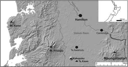
Figure 1. Locality map of the western Waikato Region.
Here we examine the volcanic history and petrologic evolution of Maungatautari by integrating geological, geomorphological, volcanological and geochemical aspects of the mountain. Building on previous work, we re-evaluate the volcanic history of Maungatautari and provide new insights into how Maungatautari relates to Early Pleistocene volcanism elsewhere in the Waikato region.
Methods
Field methods
Field observations and samples were collected from various rock outcrops across the mountain. Where pyroclastic deposits were exposed, stratigraphic logs were composed featuring descriptions of the componentry, texture, structures (if present) and contact relationships. The successions were divided into stratigraphic units, which have distinct identifiable depositional layers with clear textural or compositional boundaries.
Laboratory analysis
The geomorphology and volcanic geology of the Maungatautari edifice was examined using a combination of field observations, aerial photographs, an 8 m resolution digital elevation model (DEM) (Land Information New Zealand Citationn.d.) and descriptions of new and known exposures across the mountain. A geological map, topographical profiles, slope angles and rock avalanche volumes were all derived using ArcGIS™.
Petrographical techniques involved optical microscopy of thin sections and X-ray powder diffraction (XRD). Quantitative data on mineral and groundmass abundances were obtained by point counting with a stage interval of 0.3 mm and a minimum of 350 counts per slide. XRD was used to identify primary and secondary mineralogy on hydrothermally altered samples. Analysis was carried out on dried whole rock samples which were crushed into a fine powder using a tungsten-carbide ring mill. Prepared samples were analysed at the University of Waikato using a Panalytical Empyrean XRD and run through 2°–80° 2θ at 50 seconds per step.
Analytical methods
Major element geochemical analysis was conducted using the Bruker S8 Tiger X-ray fluorescence (XRF) spectrometer at the University of Waikato. Major element abundances cited in the text and shown on diagrams were recalculated to total 100 wt% on an anhydrous basis. Trace and rare earth elemental analysis employed LA-ICP-MS where samples were prepared using the method outlined by Eggins (Citation2003), which utilises lithium borate glass fusion beads following standard preparation procedures for XRF analysis. Data was acquired using static spot analyses with a laser beam diameter of 30 µm (60 µm for NIST standards). A summary of LA–ICP–MS analytical parameters is provided as supplementary information. Abundances of SiO2 from XRF analyses, in addition to NIST 612 were used to calibrate LA-ICP-MS results (Eggins Citation2003). Two international MPI-Ding standards, StHs6/80-G and ML3B-G, were used to ensure data quality as they are of andesitic and basaltic composition respectively, which is similar to the rock types found at Maungatautari. Mean replicate abundances of Sr, Zr, Nb, Ba, La, Ce, Pr, Sm, Dy, Ho, Th and U are within ± c. 5% of the recommended values (Jochum et al. Citation2005). Sc, V, Rb, Y, Cs, Eu, Gd, Er, Yb and Pb are within ± c. 10% of the values in Jochum et al. (Citation2005) with measurements of Nd for StHs6/80-G higher by ca 25%–35%. Sn demonstrated poor precision for both standards with values at least 50% higher than those stated by Jochum et al. (Citation2005) and was subsequently not used.
Five samples were analysed for Sr and Nd isotopes by the Geochemistry Laboratory of the School of Geography, Environment and Earth Sciences of Victoria University of Wellington, New Zealand. Following the concomitant isolation procedure of Pin et al. (Citation2014), the Sr and Nd fractions were analysed for isotopic ratios using a ThermoFinnigan Triton thermal ionization mass spectrometer (TIMS). Total procedural blanks were less than 100 pg for both Sr and Nd, which can be considered negligible compared to the >1000 and >400 ng taken for isotopic analysis for Sr and Nd respectively. Two 500 ng loads of the NBS 987 standard gave 87Sr/86Sr = 0.7102561 ± 0.000004 (2SE) and 0.7102558 ± 0.000004 (2SE). The values were identical to the long-term instrument average 87Sr/86Sr = 0.7102560 ± 0.000006 (2SD, n = 16). Two runs of the ‘in house’ J&M standard gave 143Nd/144Nd = 0.511817 ± 0.000004 (2SE) and 0.511819 ± 0.000006 (2SE). These values were identical to the long-term average for the J&M standard 143Nd/144Nd = 0.511818 ± 0.000004 (2SD, n = 34). Data was corrected for fractionation to 86Sr/88Sr = 0.1194 and 146Nd/144Nd = 0.7219 using the exponential law. The full dataset (with 2σ errors) is available as online supplementary data.
Results
Geomorphology and regional geology
Roughly circular in shape, Maungatautari is 6–8 km in diameter at its base. With a present summit altitude of 797 m above sea level, it is the second highest volcano of the Waikato region after Mount Pirongia of the Alexandra Volcanic Group (). The mountain is typified by sharply convex ridgelines with steep (>25°) slopes in the upper portions of the mountain grading down flank to more rounded, gentle to moderate (6°–25°) slopes. The flanks are dissected by deeply incised gullies, with those of the Ruapeka and Mangapiko and the Mangaohoi and Mangakara streams () on the northwestern and southern slopes, respectively, being especially broad and well developed. The volcanic vents of Kairangi, Oreipunga and an inferred eroded summit vent centred near Maungatautari Trig display a distinct northwest alignment; a trend well recognised in the nearby Alexandra and Kiwitahi volcanic groups.
Figure 2. Geologic map for Maungatautari and its surrounds with lithologies of key in situ outcrops identified.
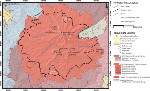
Maungatautari overlies Jurassic Manaia Hill group rocks of the Waipapa Terrane and abuts a range of the same rocks immediately to the west (Leonard et al. Citation2010). To the north, east and south, it is surrounded by a thick (>100 m) ignimbrite plateau which overlies the lowermost flanks of the mountain and is comprised of deposits of the Pakaumanu Group, which includes the Rocky Hill and Kidnappers (Raepahu Formation) and the Ahuroa (Mangaokewa Formation) ignimbrites, originating from the Mangakino caldera to the southeast (Olissoff Citation1981; Leonard et al. Citation2010). A new geological map, presented here (), is mostly consistent with that of Leonard et al. (Citation2010), except that the extended ring plain of lahar deposits to the north and encircling the mountain has been replaced here with Raepahu Formation in the east and undifferentiated ignimbrites of the Pakaumanu Group in the north and south.
Across the edifice, rock types for key sample localities are highlighted and consist of a variety of volcanic and mass wasting deposits, including volcaniclastic and hydrothermal breccias, lavas and pyroclastic deposits.
Rock avalanche deposits
On the northeastern flank of Maungatautari (), a rock avalanche is characterised by a horseshoe-shaped, steep-sided break-away scarp and large hummocks which cover a depositional area approximately 1.6 km2 in size, extending to the northeast (A). The northern and southern deposit boundaries mirror the scarp of the mountain with the hummocks becoming obscured east of Roberts Road. As such, the volume of the original rock avalanche deposit has been determined using cross-sectional GIS topographic profiles of the scarp (e.g. in B) and is estimated to be 0.28 km3.
Figure 3. Geomorphology of the Maungatautari rock avalanche. A, View eastward of the area affected by a rock avalanche from the top of the breakaway scarp. The steep-sided walls are covered in native bush and form a characteristic horse-shoe pattern surrounding predominantly flat, poor-draining land. Arrows point to large hummocks which lie to the east from the edge of the tree line. B, North-south and west-east GIS cross-sectional profiles outlined in . C, Large proximal hummock consisting of medium-sized, poorly sorted and massive angular to sub-angular blocks and matrix mantled by post-collapse tephra deposits.
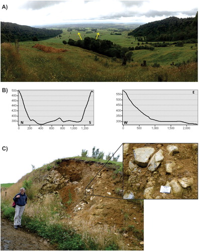
Internally, hummocks consist of poorly-sorted blocks of porphyritic andesite within a finer grained matrix of similar lithology (C). Large angular to sub-angular blocks up to 2 m wide by 3–4 m long consist of dense, feldspar-rich porphyritic andesite with coarse jointing. Some andesite blocks contain abundant, sub-spherical <10 cm-sized clasts of hornblende-rich, yellow xenoliths, interpreted by Briggs (Citation1986a) to be cognate xenoliths. A few smaller blocks, however, were found to be composed of basement-derived chipwacke. Hummocks are covered by 0.5 m of a red-orange, well-developed soil overlain by ∼15 cm of dark brown organic rich soil. The head of the collapse scarp is obscured by a steep talus slope which accumulated within the rock avalanche source area. It extends approximately 700 m into the centre of the excavated area, and is overlain by subsequent rock fall, slide and debris flow deposits.
Volcaniclastic breccias
Localised outcrops of volcaniclastic breccias occur within stream valleys throughout the upper and lower flanks of the edifice. The breccias are non- to reversely-graded and composed of angular to sub-rounded cobbles and boulders of non-vesicular, porphyritic hornblende-rich andesitic-dacitic lavas within a massive and poorly sorted (silt-pebble sized) matrix. Across the lower slopes, these breccias are stratigraphically intercalated with ignimbrites of the Pakaumanu Group (Olissoff Citation1981).
Hydrothermally-altered zones
A localised area of hydrothermally-altered andesite is exposed within the headwaters of the Mangakara Stream in a pit excavated in the late nineteenth or early twentieth century during gold prospecting (). In-situ fluid-assisted brecciation has fragmented the host lava creating a mosaic-like texture of angular clasts, 1–4 cm in size with relict porphyritic texture. Clasts show little rotation and fit together in a jigsaw-like fashion and are surrounded by an alteration matrix consisting of a fine-grained crystalline quartz-rich medium. Alteration minerology, determined by XRD analysis, consists of cristobalite, alunite and kaolinite within the intensely altered inner zone and albite in samples obtained from the outer portion of the lava flow.
Maungatautari lavas
Across the Maungatautari edifice, exposed lavas are generally non-vesicular, porphyritic andesites and dacites with varying amounts of plagioclase, clinopyroxene, orthopyroxene and hornblende phenocrysts and xenoliths. Olivine basalt was obtained from the nearby cone of Kairangi, located 7 km to the northwest of the Maungatautari trig. Kairangi cone is compositionally distinct from the range of lava compositions found across Maungatautari but has been included in this study due to the proximity of the two edifices and as the petrogenetic relationship between the two volcanoes has not been fully explored. An outcrop of hornblende dacite located at Rocky Outcrop () represents a late-stage dike, consistent with the radial dikes of Little Rock, Hook Nose (Olson Citation1950) and Te Akatarere (Briggs Citation1986a).
Petrography and mineralogy
The porphyritic Maungatautari lavas often display seriate textures with phenocrysts occasionally clustered as glomerocrysts. Whole-rock phenocryst abundances range from 22% to 53% and include plagioclase, orthopyroxene, clinopyroxene, hornblende, and opaque Fe-Ti oxides (; A–C). Samples have been differentiated using modal composition and SiO2 content based on previous classifications by Cole (Citation1978) and Briggs (Citation1986a). Olivine basalt, found exclusively at Kairangi cone (D), contains abundant olivine phenocrysts that are visible in hand specimens. The andesites and dacites of the Maungatautari volcano sensu stricto are separated into: labradorite andesites, defined as containing total modal plagioclase > pyroxene; pyroxene andesites having total modal pyroxene >15%; and hornblende andesites and dacites containing significant hornblende also visible in hand specimen. Representative modal analyses of lavas sampled in this study are presented in .
Figure 4. Representative mineralogy and micro-textures of Maungatautari A, labradorite andesite, B, pyroxene andesite, C, hornblende dacite and D, Kairangi olivine basalt. Abbreviations: Pl = plagioclase; Cpx = clinopyroxene; Opx = orthopyroxene; Hbl = hornblende, Ol = olivine.
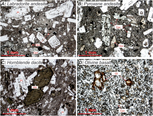
Table 1. Modal analyses (count %) of selected Maungatautari lavas based on a minimum of 350 counts per slide.
Phenocrysts are set in a fine grained, plagioclase lath-dominated groundmass with intergranular, intersertal, trachytic and hyalopilitic textures. Plagioclase is the most abundant phenocryst phase in all Maungatautari lavas, comprising from 18% to 37% of the whole rock with sizes typically 1.5–2 mm. A few megacrysts, were found to be as large as 2.5–3 mm in size. Oscillatory zoning and sieve-textures are common.
The abundance of total pyroxene ranges from <1% to 18% of the whole rock with orthopyroxene always subordinate to clinopyroxene. Crystals of both pyroxenes are euhedral to subhedral with sizes typically in the range of 0.5–1.25 mm, with rare crystals up to 2 mm observed.
Hornblende occurs predominantly in Maungatautari dacites, but it is also found in some andesites. Crystals are elongate and are <2.5 mm in length with modal abundances of up to 19%. Many crystals show alteration to fine-grained aggregates of Fe-oxides and/or pyroxene with some being completely pseudomorphed.
Pyroclastic deposits
This study is the first to document a record of explosive volcanism at Maungatautari. Two successions named Quarry #34 (Q34) and the Summit Quarry (SQ) () were divided in the field into stratigraphic units (QT1-QT9 at Q34, ; SQ1-SQ3 at SQ, ), defined as distinct identifiable depositional layers with clear textural or compositional boundaries. Units were assigned one of five different facies types based on textural and structural differences (Facies A-E below, –).
Figure 5. Quarry #34. A, Stratigraphic log showing units QT1 to 9, and the facies type assigned to each unit. B, Outcrop photograph.
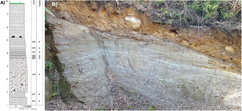
Figure 6. Summit quarry. A, Stratigraphic log showing units SQ1 to 3, and the facies type assigned to each unit. B, Outcrop photograph.
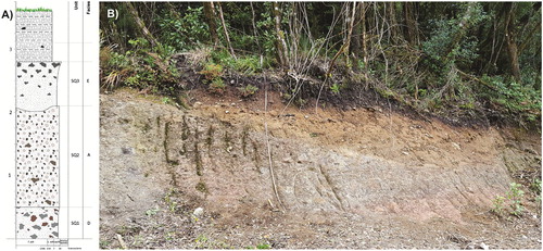
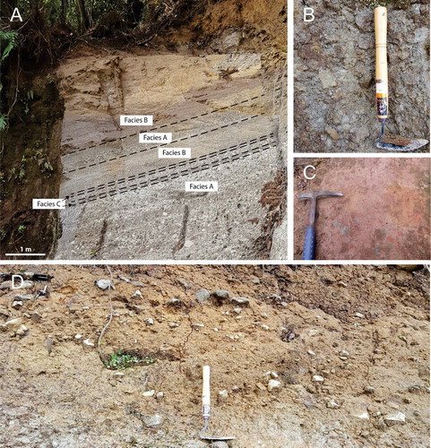
Figure 7. A, Facies A, B and C in outcrop at quarry #34 where the massive lapilli tuff of facies A contrasts with the laminated-bedded crystal and lithic-rich coarse tuff and very-fine lapilli of facies B. The thin tuff beds of facies C form two thin and laterally continuous bands across the outcrop. B, Facies A within unit SQ2 at the summit quarry. C, Facies D in outcrop at the summit quarry displaying red-coloured, matrix-supported, poorly sorted, non-welded massive lapilli-block tuff. D, Facies E of unit SQ3 within the summit quarry showing reverse grading of blocks and a fines-rich basal layer marked near the base of the photo by the top of the scraper which is used for scale.
Facies A – Massive, moderately-poorly sorted, fine to coarse lapilli tuff
Facies A is characterised by massive, moderately to poorly sorted fine to coarse lapilli tuff and comprises more than half of the stratigraphic thickness of the successions at each site and the entire thickness of units QT1, QT3, QT5, QT8 (Q34, ) and SQ1 (SQ, , B). Units vary from 0.2 m to up to 2.6 m in thickness, with the thicker units consistently found within the lower half of the successions. The upper stratigraphic units of this facies are finer-grained than the lower units and consisted of fine to medium lapilli tuff.
Facies B – Laminated to very thinly bedded crystal and lithic-rich coarse tuff and very-fine lapilli
Facies B consists of laminated (<1 cm in thickness) to very-thinly bedded (1–2 cm), crystal- and lithic-rich coarse tuff and very-fine lapilli which comprises three stratigraphic units within the Q34 succession: unit QT2, 0.4 m thick; unit QT7, 0.35 m thick; and unit QT9, 0.7 m thick ( and A).
Parallel stratification of facies B within unit QT2 occurs as very thin beds up to 2 cm thick. The maximum thickness of this unit is 0.4 m, however, the upper contact undulates which causes the thickness of this unit to range from 0.2 to 0.4 m across the exposure. The internal stratification of facies B within units QT7 and QT9 forms alternating coarse laminations, rather than thin beds, of coarse tuff and fine lapilli and both units display normal grading.
Facies C – Massive coarse tuff
The two very thin beds (0.015–0.03 m thick; QT4 and QT6 respectively) of facies C, were characterised as laterally continuous, red-coloured, massive, well sorted coarse tuff (A). This facies was only present at Q34 and directly overlies units of facies A ().
Facies D – Non-welded massive lapilli-block tuff
This facies comprises SQ1 of the SQ succession () and consists of a red-coloured, matrix-supported, non-welded, massive lapilli-block tuff (C). It is distinguished from the massive lapilli tuff of facies A by a significantly higher proportion of angular blocks and ash matrix, estimated to be 5%–7% and 60%–70% of the bulk deposit respectively.
Facies E – Massive and poorly sorted silty sandy gravel, with reversely graded blocks
The upper stratigraphic interval at SQ (unit SQ3, , D), consists of reversely graded blocks of non-vesicular, porphyritic hornblende-rich andesitic-dacitic lavas within a massive and poorly sorted (silt-pebble sized) matrix. The lensoidal geometry of this unit, lack of juvenile clasts, distinctive matrix texture and fines-rich base distinguishes this facies from those previously described.
Componentry
The major components of the eruptive deposits are lapilli- to block-sized pyroclasts comprising a mixture of (i) crystal-rich, vesicular and non-vesicular juvenile clasts, (ii) dense lithics of angular fresh, weathered and/or hydrothermally-altered andesite-dacite lava, and (iii) within units QT1 and QT3 at Q34, sub-rounded fragments of poorly sorted fine-grained sandstones. Clasts are contained within a non-welded, crystal- and lithic-rich coarse tuff matrix, except for facies E which is more poorly sorted.
Juvenile clasts include both vesicular and non-vesicular, hornblende-rich pumice which ranges from 2–3 to 20 cm in diameter. In both types, the dominant phenocryst mineral phases are plagioclase along with hornblende, rare pyroxenes and disseminated opaque minerals. Lithics include angular fragments of fresh, weathered and/or hydrothermally altered, dense, porphyritic andesite-dacite lavas and greywacke. Individual clast sizes range from 1–2 cm to up to ∼ 8 cm or 21 cm in diameter. Lithics of greywacke were found within units QT1 and the lower half of unit QT3, 1–2 m above ground level at Q34. Greywacke lithics were not observed within the deposits at SQ.
Whole-rock geochemistry of lavas
Lava compositions range from basalt at Kairangi, to med-high K andesites and dacites (57–66.45 wt.%, normalised to 100% volatile free) at Maungatautari (). No samples of basalt or basaltic andesite composition have currently been found across the Maungatautari edifice.
Table 2. Representative whole rock geochemical analyses by XRF and LA-ICP-MS for Maungatautari lavas.
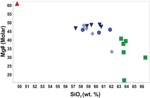
With increasing SiO2 content, there is a progressive decline in abundance of Fe2O3, CaO, MgO and TiO2, and increases in Na2O and K2O, consistent with the trends described by Briggs (Citation1986a) (). Within the trace elements, Rb, Zr, Nb, Cs, Ba and Th abundances are positively correlated with SiO2 content, whereas Sc, V, and Sr decrease with increasing SiO2 abundance. The Mg# of Maungatautari lavas varies between 30 and 49 ().
Figure 8. Selected Harker diagrams for Maungatautari and Kairangi lavas.
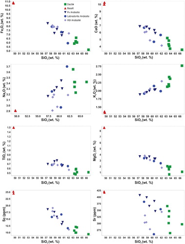
Figure 9. Mg# versus silica for Maungatautari and Kairangi lavas.
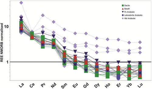
A primordial mantle-normalised multielement diagram is shown in . There is a distinct decoupling of the large ion lithophile (LIL) elements K, Rb, Cs and the high field strength (HFS) elements Zr, Nb, Th, U and rare Earth elements. Unusually high MORB normalised REE values () coupled with negative Ce anomalies and high Y concentrations (93–166 ppm) were obtained from three low-silica hornblende andesites.
Figure 10. Primordial mantle normalised multi-element diagram for representative Maungatautari and Kairangi lavas. Normalisation factors after Taylor and McLennan (Citation1985).
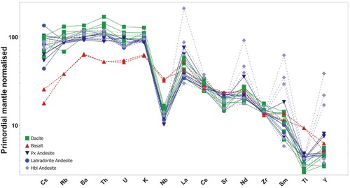
Figure 11. NMORB normalised REE diagram for representative Maungatautari and Kairangi lavas. Normalisation factors after Sun and McDonough (Citation1989).
Isotopic ratios for samples from across the main edifice show little spread (87Sr/86Sr = 0.704478–0.704784; 143Nd/144Nd = 0.512771–0.512810) and are comparable to those of the Coromandel Volcanic Zone and Alexandra Volcanic Group (). The hornblende andesite (ORE040) and dacite (ORE039b) have higher 87Sr/86Sr ratios and lower143Nd/144Nd than those obtained from the pyroxene and labradorite andesites (samples GF006 and MRd020), and displaced towards typical compositions of the Waipapa terrane metasedimentary basement rocks.
Figure 12. Radiogenic Sr and Nd isotopic compositions of representative Maungatautari and Kairangi lavas compared with Ruapehu andesites and basalts (Waight et al. Citation1999; Price et al. Citation2012), Coromandel Volcanic Zone (Huang et al. Citation2000), Mt Taranaki (Price et al. Citation1999), Alexandra Volcanics and Okete Volcanic Group (Briggs and McDonough Citation1990). Data for the regional basement terrane (Price et al. Citation2015) and MORB lavas (Ito et al. Citation1987) are also included for reference.
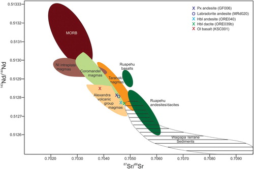
Geochemical results pertaining to the olivine basalt from Kairangi (KSC001) are typically isolated from the general trends described above. Using the Nb/Y classification diagram of Winchester and Floyd (Citation1977), this sample is classified as an alkali basalt. Whole-rock concentrations of Fe2O3, CaO, MgO and TiO2 are higher while Na2O, K2O and Al2O3 are lower than those analysed from Maungatautari () and consistently lie off general trends. A similar occurrence is present for many of the trace elements (e.g. Rb, Sr, Zr, Nb, Cs, and Ba), however, concentrations for the rare earth elements are more similar to those found in the andesites and dacites of Maungatautari (–). 143Nd/144Nd and 87Sr/86Sr isotopes are also significantly different at 0.512849 and 0.703850, which overlap with basalts of the Alexandra Volcanic Group and approach the intraplate magmas of the Okete field ().
Discussion
Volcanic geology
Revision of geological map
The geological map presented in shows the distribution of key geological units in the Maungatautari area and provides lithologies for key outcrops of volcanic rocks across the main edifice. The wider correlation of volcanic units was not undertaken during this study. Our revised map replaces the extensive ring plain deposits (c.f. Leonard et al. Citation2010) with undifferentiated ignimbrites of the Pakaumanu Group in the north and south of the mountain and Raepahu Formation to the east. This change reflects field evidence of onlapping Rocky Hill ignimbrite deposits found in the vicinity of Oreipunga cone, channelised lahar deposits (consistent with Briggs (Citation1986a)) and stratigraphic logs of water bores from Waikato Regional Council (Citationn.d) which are dominated by ignimbrite and lack volcanic breccias indicative of extensive ring plain deposits near the surface. Undifferentiated ignimbrite bluffs were also observed in road cuttings in the valley between Maungatautari and the Pukekura Hills west of Maru Road, and no fresh outcrops were observed to the north of Maungatautari.
Rock avalanche
The hummocks found extending north-east from the upper flank of Maungatautari were first described by Olson (Citation1950) as lahar mounds, but are now recognised as rock avalanche deposits resulting from large scale flank failure (also commonly referred to as debris avalanches; cf. Siebert Citation2002; Hungr et al. Citation2014). The deposits of this 0.28 km3 rock avalanche are typical, consisting of a horse-shoe-shaped, steep-sided break-away scarp and large hummocks comprised of angular to sub-angular, small to large-sized boulders of porphyritic andesite and chipwacke within a finer grained matrix of similar lithology. Basement rocks do not outcrop at the surface in the north-eastern section of the mountain and its depth below the present surface cannot be reliably determined due to the limited number of water bores and variability in the number and degree of certainty of lithological descriptions in stratigraphic logs. The presence of basement-derived blocks of chipwacke within the rock avalanche deposit, indicates that the failure plane cut below the volcanic edifice into the underlying substrata. This suggests that in the vicinity of the scarp, the basement is relatively shallow and may represent a paleo-topographic high which lies under the present edifice. Such deep seated failures are not uncommon (De Vries et al. Citation2001; Shea et al. Citation2008; Paguican et al. Citation2012) and can occur multiple times on the same volcano, often triggered by movement on underlying faults (Paguican et al. Citation2012). While no known faults lie beneath Maungatautari, active basement structures in the southern Waikato Basin at this time are unknown and therefore a tectonic-induced collapse cannot be excluded, nor can any edifice instability caused by nearby hydrothermal centres. However, as there is no evidence of contemporaneous magmatic activity, a non-volcanic trigger for the sector collapse is suggested.
Hydrothermal centres
An alteration mineral assemblage of andesitic rocks in the Mangakara Stream consisted of cristobalite, alunite and kaolinite and is characteristic of advanced argillic hydrothermal alteration and representative of a low-sulfidation hydrothermal system (Browne and Simmons Citation2000; Hedenquist et al. Citation2000). Volatiles degassing from deep underlying boiling magmatic fluids, ascend and condense into the meteoric waters of the water table, creating acidic waters, severe leaching and weakening of the host rock typically only up to several metres in thickness with temperatures seldom exceeding 100°–120°C (Hedenquist et al. Citation2000). Briggs (Citation1986a) describes a sub vertical shear or fault zone in this area and highlights the effect localised hydrothermal alteration plays in the stability of the overall edifice (e.g. Lopez and Williams (Citation1993)), and may have helped prime the north-eastern flank for failure. In addition to the Mangakara Stream site, Briggs (Citation1986a) recognised a second system in the headwaters of the Otautora Stream, suggesting that hydrothermal activity on the upper flanks may have been extensive. Surface manifestations would of consisted of highly acidic fumaroles and/or hot springs such as those found at Ketetahi springs on the upper flanks of Mt Tongariro (Simmons et al. Citation2005).
Interpretation of pyroclastic facies and eruption styles
The products of effusive volcanism dominate preserved deposits across the Maungatautari edifice as they are more resistant to erosion than those from explosive eruption styles. Where pyroclastic deposits were observed (Q34 and Summit Quarry), individual stratigraphic units have been attributed to distinct facies (A-E) with interpretation based on textural and compositional differences.
Facies A, B, C and D are interpreted to represent deposits of syn-eruptive pyroclastic density currents (PDCs). Facies A and B consist of massive to bedded, graded to non-graded, poorly-sorted lapilli to block tuffs. Compositionally similar, they are distinguished on the basis of bedding characteristics of individual units which may relate to differences in particle concentration, flow steadiness and/or depositional processes (Sulpizio and Dellino Citation2008). Facies C directly overlies units of PDC deposits of Facies A and is believed to represent fallout ash from a buoyant co-PDC plume during a pause in PDC activity (Brown and Andrews Citation2015). Facies D consists of a significantly higher proportion of angular blocks and ash matrix, lack the juvenile clasts found in Facies A and B, and has been interpreted as a block and ash flow deposit.
Facies E was only observed at the summit quarry site (SQ3) and consists of reversely graded blocks of non-vesicular, porphyritic hornblende-rich andesitic-dacitic lavas within a massive and poorly sorted (silt-pebble-sized) matrix. Based on deposit geometry, block composition, poorly-sorted matrix and distinct fines-rich base, this facies is interpreted to have been deposited by a lahar, however, whether this was generated during an eruptive event or during a period of quiescence that followed is undetermined.
Facies interpretation suggests contrasting eruptive histories for the two pyroclastic successions (Q#34 and the SQ). The succession at Q#34 depicts multiple PDC's (units QT1, QT2, QT3, QT5, QT7, QT8 and QT9; ), some with upper co-fall deposits (units QT4 and QT6). Lithics of sedimentary lithology found in units QT1 and QT3 are likely to be derived from the underlying Jurassic strata and may be attributed to either conduit erosion, fragmentation depth and/or energy increases (Hildreth Citation1987; Pardo et al. Citation2012). In contrast, the gradational change between units SQ1 into SQ2 () at the summit quarry succession depicts a block and ash flow followed by a more pumiceous pyroclastic density current, which may reflect a lava dome collapse or vent clearing episode (cf. Cole et al. Citation2015; Torres-Orozco et al. Citation2018). The upper stratigraphic unit (SQ3), is texturally distinct from all other primary volcanic facies and this unit is interpreted to be a subsequent lahar or debris flow, which has flowed downslope within an eroded channel.
Despite limited exposure outcrops across the mountain, these successions demonstrate eruptive events at Maungatautari consisted of complex, multiple phase eruptions, that may have included cycles of dome growth and collapse, lava flows and the production of explosive eruption columns probably from associated vulcanian to sub-plinian style activity, which created numerous PDCs likely centred at a now-eroded summit vent.
Petrogenesis of magmas
The decoupled LIL/HFS pattern and Nb trough in the mantle-normalised multi-element diagram (), is a distinctive feature of subduction zone magmas. The progressive decline in abundance of Fe2O3, CaO, MgO and TiO2, with concurrent increases in Na2O and K2O with increasing SiO2 content, implies, at least qualitatively, that the evolution of Maungatautari lavas was dominated by the fractional crystallisation of a parent magma. However, magma petrogenesis at Maungatautari and its subsequent evolution is much more complex. Trace element and isotopic ratios (; –) suggest that erupted magma compositions are more likely the result of mixing between more evolved crustal and primitive melts that have very different histories, though sharing the same sources and processes in various proportions (Eichelberger et al. Citation2006). This is supported texturally in plagioclase crystals which show oscillatory zoning and have sieved cores, recording complex crystallisation histories and periods of melt disequilibrium.
The eruption of high magnesium number (Mg#) lavas has occurred at numerous North Island volcanoes (Cole and Teoh Citation1975; Froude and Cole Citation1985; Booden et al. Citation2010). Defined by Kelemen et al. (Citation2013), high-Mg# andesites are rocks with >54 wt.% SiO2 and Mg# 50–60, with primitive magmas are considered to have Mg# >60. With Mg numbers of between 30 and 49, Maungatautari lavas are not primitive, nor can they be classified as high-Mg# andesites (). Eleven samples have Mg# of between >46 and 49 and are considered to represent least evolved erupted magmas which consist of pyroxene andesites and three samples of hornblende andesite. While primitive basalts occur in a variety of tectonic settings, rocks of this composition have not been found at Maungatautari, however, they may have been emplaced as plutonic rocks within the middle and upper crust (Gill Citation1981; Annen et al. Citation2006; Kelemen et al. Citation2013). Alternatively, Maungatautari magmas may have evolved from a primitive andesitic melt (Annen et al. Citation2006; Wood and Turner Citation2009).
Trace element data and isotopic ratios also suggests three separate mantle sources for the identified rock types. Across the Maungatautari edifice, most andesites and dacites are petrogenetically related and ultimately derived from a deep garnet-bearing source rock suggested by the depletion of HREE and Y, in which they are strongly compatible and retained at the expense of the melt (Alonso-Perez et al. Citation2009). The low-SiO2 hornblende andesites have LIL element concentrations consistent with other samples from the main Maungatautari edifice, but are more enriched in the HREEs and Y ( and ), and more reflective of partial melting of mantle rocks where garnet was not a stable phase. The negative Ce anomalies in apparently fresh and unaltered rocks in both hand specimen and thin section has also been documented within basalts from Hawaii (Roden et al. Citation1984) and southeast Australia (Price et al. Citation1991), along with some basaltic to andesitic samples from the Kiwitahi Volcanics of the Coromandel Volcanic Zone (Kuschel and Smith Citation1992). This phenomenon has been attributed to weathering (Roden et al. Citation1984; Price et al. Citation1991) and cryptic hydrothermal alteration (Kuschel and Smith Citation1992). In contrast, Neal and Taylor (Citation1989) suggests it reflects the recycling of crustal materials within the upper mantle. The samples in this study were collected from opposing sides of the mountain removed from any locations of known hydrothermal activity and show no evidence of weathering or major element mobility. As such, the data has been retained for the purpose of this study. The Kairangi olivine basalts have markedly different multi-element patterns being less enriched in LIL elements with a less pronounced negative Nb anomaly (). The smoother pattern in the multi-element diagrams is more reflective of intraplate over subduction-related melts (Winter Citation2014) and along with major element and isotopic data excludes the Kairangi olivine basalt from being petrogenetically related to the andesites and dacites of the Maungatautari magmatic system.
Local and regional geochemical affinity
Currently, Maungatautari is considered as a subduction-related volcano situated behind the volcanic front active approximately 1.8 Ma (Briggs Citation1986a). However, the trace and rare earth element geochemical data presented in this study have provided new insight into the relationship between Maungatautari and the other volcanic centres active c. 2 Ma.
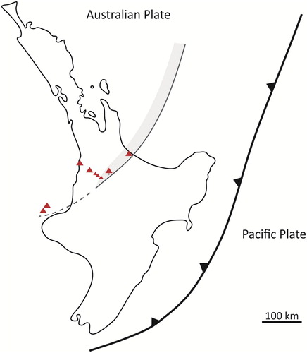
The magmatic system which produced Maungatautari lavas have multi-element and REE patterns consistent with arc-related volcanism (). A similar pattern is also seen within the Alexandra and Taranaki magmas, except with positive anomalies in Ba and Sr and higher-K contents. At Taranaki, enrichment in these elements has been attributed to a complex interplay between variations in mantle source, slab fluid compositions, degree of partial melting of source along with crustal contribution and thickness (Price et al. Citation1999, Citation2005). With negative Ba and Sr anomalies, Maungatautari's multi-element and REE patterns medium-K contents, best reflect those from Coromandel Volcanic Zone and Mt Ruapehu andesites. Volcanism at Maungatautari is therefore interpreted to represent magmatism associated with the volcanic arc front, which extended south from Tauranga to Maungatautari during this time (). The late-stage andesitic volcanism of the near-by Alexandra Volcanics is viewed as contemporaneous, behind-arc subduction-related volcanism, and was first proposed by Briggs et al. (Citation2013). The alkali olivine basalt at Kairangi displays a distinct intraplate signature and is therefore unrelated to magmatism at Maungatautari although the exact temporal relationship between the two magmatic series remains uncertain. The coeval occurrence of intraplate alkali basalts alongside subduction-related magmas is well documented within the nearby Alexandra and Okete volcanic groups (Briggs et al. Citation1989; Briggs and McDonough Citation1990), although the mechanisms which result in the occurrence of two contrasting magma series within a clearly convergent tectonic setting remains uncertain.
Figure 13. Primordial mantle normalised multi-element diagram for averaged geochemical data from the Coromandel Volcanic Zone (Booden et al. Citation2012), Kiwitahi (Booden et al. Citation2010), Ruapehu (Price et al. Citation2012), Alexandra (Briggs and Goles Citation1984; Briggs Citation1986b) and Taranaki (Price et al. Citation1999) volcanic centres and the Okete intra-plate volcanics of the western North Island (Briggs and McDonough Citation1990). Normalisation factors after Taylor and McLennan (Citation1985).
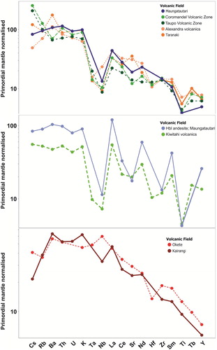
Figure 14. Schematic map showing the estimated position of the volcanic arc at c. 2 Ma and its propagation through the western North Island to include Maungatautari. Active volcanic centres are shown by red triangles. The continuation of the arc to include the western Taranaki Graben Volcanoes (dashed line) remains speculative.
Interpretation of the volcanology and evolution of Maungatautari
Age data for Maungatautari is limited and as such, the volcanic evolution of Maungatautari area is based on the stratigraphic relationships between the underlying basement rocks, the Maungatautari volcanic succession and the onlapping ignimbrite succession and mass wasting events.
Early volcanism within the Maungatautari area included the eruption of alkali olivine basalt 2.62 Ma (Briggs et al. Citation1989) to produce the small basalt cone of Kairangi which sits on uplifted and eroded Jurassic Manaia Hill group rocks of the Waipapa Terrane. The centre of volcanism then shifted 7 km southeast where, over time, the repeated eruption of intercalated small flows and domes of viscous andesitic-dacitic lavas and pyroclastic deposits from vulcanian to possibly sub-plinian eruption styles formed the roughly circular edifice of Maungatautari which has a single radiometric age of c. 1.8 Ma (Robertson Citation1983). An eruption of dacitic magma on the eastern flank led to the development of Oreipunga Cone.
Thermal energy and magmatic fluids provided by the underlying magmatic system, interacted with meteoric water to produce acidic fumaroles and hot springs on the upper slopes of the mountain in what is now the headwaters of the Mangakara and Otautora Streams.
Eventually, volcanism at Maungatautari ceased as andesitic arc-volcanism shifted south and east to the developing Taupo Volcanic Zone. The eruption of ignimbrites from the Mangakino caldera, located to the southeast, resulted in the deposition of the plateau surface, which now surrounds Maungatautari. The timing of the rock avalanche event in the northeast corner is poorly constrained, but the lack of edifice reconstruction and absence of ignimbrites over or between hummocks suggests it occurred within the last one million years after both the volcanic activity at Maungatautari had ceased and the ignimbrite plateau had been emplaced. The ongoing erosion of Maungatautari continues to shape the remains of the edifice present today.
Conclusions
Maungatautari is an andesitic-dacitic composite cone which overlies and abuts, on its western side, Jurassic Manaia Hill group rocks of the Waipapa Terrane. The northern, eastern and southern lowermost flanks are onlapped by ignimbrites derived from the Mangakino caldera to the southeast, which forms a plateau surface that buries much of the volcanic ring plain. Catastrophic failure of the northeastern flank produced a 0.28 km3 rock avalanche deposit characterised by large hummocks that cover a depositional area approximately 1.6 km2 in size, and associated landslide scarp.
Lavas at Maungatautari were derived from at least three distinct mantle-melt sources with most andesites and dacites being petrogenetically related and associated with the fractionation of subduction-related, deep, garnet-bearing, depleted mantle source rock. In contrast, the low SiO2 hornblende andesites and Kairangi olivine basalt are derived from a shallower upper mantle (garnet-free) source rock and an area of deeper enriched mantle, respectively.
Eruption styles at Maungatautari include the effusion of lava flows and domes, and vulcanian to sub-plinian explosive eruptions which produced numerous PDCs. An isolated area of hydrothermal activity on the upper flanks has modified the volcanic rocks in this area.
Volcanism at Maungatautari is interpreted to be part of the volcanic arc front, which extended south into continental New Zealand from Tauranga to Maungatautari c. 2 Ma with late stage andesitic volcanism of the near-by Alexandra Volcanics being contemporaneous, back-arc subduction related volcanoes. The alkali olivine basalt at Kairangi is more reflective of intraplate over subduction-related melts and is not petrogenetically related to magmatism at Maungatautari.
Supplemental data
Download MS Excel (33.5 KB)Acknowledgements
MLP gratefully acknowledges the Waipa District Council, Maungatautari Ecological Island Trust (MEIT), Ngāti Korokī Kahukura along with Ruakawa, Tainui and Ngāti Hauā for granting consent for this study to take place within the confines of the reserve. Practical support within the sanctuary was provided by James Matthews and Craig Laxon. Thank you also to Bill Garland, John Scott and Mo who provided unrestricted access to private land. We thank the UOW School of Sciences technical staff for their expertise and guidance, Bruce Charlier (Victoria University of Wellington) for isotope data, and the thorough reviews by two anonymous reviewers who greatly improved the presentation of our results.
Disclosure statement
No potential conflict of interest was reported by the authors.
ORCID
S. L. L. Barker http://orcid.org/0000-0002-4383-8861
Additional information
Funding
Related Research Data
References
- Alonso-Perez R, Müntener O, Ulmer P. 2009. Igneous garnet and amphibole fractionation in the roots of island arcs: experimental constraints on andesitic liquids. Contributions to Mineralogy and Petrology. 157(4):541–558. doi: 10.1007/s00410-008-0351-8
- Annen C, Blundy J, Sparks R. 2006. The genesis of intermediate and silicic magmas in deep crustal hot zones. Journal of Petrology. 47(3):505–539. doi: 10.1093/petrology/egi084
- Booden MA, Smith IEM, Mauk JL, Black PM. 2010. Evolving volcanism at the tip of a propagating arc: the earliest high-Mg andesites in northern New Zealand. Journal of Volcanology and Geothermal Research. 195(2–4):83–96. doi: 10.1016/j.jvolgeores.2010.06.013
- Booden MA, Smith IEM, Mauk JL, Black PM. 2012. Geochemical and isotopic development of the Coromandel volcanic Zone, northern New Zealand, since 18Ma. Journal of Volcanology and Geothermal Research. 219–220:15–32. doi: 10.1016/j.jvolgeores.2012.01.005
- Briggs RM. 1986a. Petrology and geochemistry of Maungatautari, a medium-k andesite-dacite volcano. New Zealand Journal of Geology and Geophysics. 29(3):273–289. doi: 10.1080/00288306.1986.10422151
- Briggs RM. 1986b. Volcanic rocks of the Waikato region, western North Island, and some possible petrologic and tectonic constraints on their origin. Late Cenozoic Volcanism in New Zealand Royal Society of New Zealand Bulletin. 23:76–91.
- Briggs RM, Goles GG. 1984. Petrological and trace element geochemical features of the Okete Volcanics, western North Island, New Zealand. Contributions to Mineralogy and Petrology. 86(1):77–88. doi: 10.1007/BF00373712
- Briggs RM, Goles GG, Maas R. 2013. Karioi volcano, western North Island, New Zealand: a behind arc polygenetic intraplate-convergent margin volcanic complex. Poster presented at the IAVCEI Scientific Assembly; Kagoshima, Japan.
- Briggs RM, Itaya T, Lowe DJ, Keane AJ. 1989. Ages of the Pliocene—pleistocene Alexandra and Ngatutura Volcanics, western north Island, New Zealand, and some geological implications. New Zealand Journal of Geology and Geophysics. 32(4):417–427. doi: 10.1080/00288306.1989.10427549
- Briggs RM, McDonough WF. 1990. Contemporaneous convergent margin and intraplate magmatism, North Island, New Zealand. Journal of Petrology. 31(4):813–851. doi: 10.1093/petrology/31.4.813
- Brown RJ, Andrews G. 2015. Chapter 36 – deposits of pyroclastic density currents. In: Sigurdsson H, editor. The encyclopedia of volcanoes. 2nd ed. Amsterdam: Academic Press; p. 631–648.
- Browne PRL, Simmons SF. 2000. Hydrothermal minerals and precious metals in the Broadlands-Ohaaki geothermal system: implications for understanding low-sulfidation epithermal environments. Economic Geology. 95(5):971–999. doi: 10.2113/gsecongeo.95.5.971
- Cole JW. 1978. Distribution, petrography, and chemistry of Kiwitahi and Maungatautari volcanics, North Island, New Zealand. New Zealand Journal of Geology and Geophysics. 21(2):143–153. doi: 10.1080/00288306.1978.10424046
- Cole P, Stinton A, Odbert H, Bonadonna C, Stewart R. 2015. An inclined Vulcanian explosion and associated products. Journal of the Geological Society. 172(3):287–293. doi: 10.1144/jgs2014-099
- Cole J, Teoh L. 1975. Petrography, mineralogy, and chemistry of Pureora andesite volcano, North Island, New Zealand. New Zealand Journal of Geology and Geophysics. 18(2):259–272. doi: 10.1080/00288306.1975.10418197
- De Vries BVW, Self S, Francis P, Keszthelyi L. 2001. A gravitational spreading origin for the Socompa debris avalanche. Journal of Volcanology and Geothermal Research. 105(3):225–247. doi: 10.1016/S0377-0273(00)00252-3
- Eggins SM. 2003. Laser ablation ICPMS analysis of geological materials prepared as lithium borate glasses. Geostandards and Geoanalytical Research. 27(2):147–162. doi: 10.1111/j.1751-908X.2003.tb00642.x
- Eichelberger JC, Izbekov PE, Browne BL. 2006. Bulk chemical trends at arc volcanoes are not liquid lines of descent. Lithos. 87(1-2):135–154. doi: 10.1016/j.lithos.2005.05.006
- Froude D, Cole J. 1985. Petrography, mineralogy and chemistry of Titiraupenga volcano, North Island, New Zealand. New Zealand Journal of Geology and Geophysics. 28(3):487–496. doi: 10.1080/00288306.1985.10421201
- Gill JB. 1981. Orogenic andesites and plate tectonics. Berlin; New York: Springer-Verlag.
- Hayward BW, Black PM, Smith IEM, Ballance PF, Itaya T, Doi M, Takagi M, Bergman S, Adams CJ, Herzer RH, et al. 2001. K-Ar ages of early Miocene arc-type volcanoes in northern New Zealand. New Zealand Journal of Geology and Geophysics. 44(2):285–311. doi: 10.1080/00288306.2001.9514939
- Hedenquist JW, Arribas A, Gonzalez-Urien E. 2000. Exploration for epithermal gold deposits. Reviews in Economic Geology. 13(2):45–77.
- Hildreth W. 1987. New perspectives on the eruption of 1912 in the valley of ten thousand smokes, Katmai National Park, Alaska. Bulletin of Volcanology. 49(5):680–693. doi: 10.1007/BF01080359
- Huang Y, Hawkesworth C, Smith I, van Calsteren P, Black P. 2000. Geochemistry of late cenozoic basaltic volcanism in Northland and Coromandel, New Zealand: implications for mantle enrichment processes. Chemical Geology. 164(3):219–238. doi: 10.1016/S0009-2541(99)00145-X
- Hungr O, Leroueil S, Picarelli L. 2014. The Varnes classification of landslide types, an update. Landslides. 11(2):167–194. doi: 10.1007/s10346-013-0436-y
- Ito E, White WM, Göpel C. 1987. The O, Sr, Nd and Pb isotope geochemistry of MORB. Chemical Geology. 62(3-4):157–176. doi: 10.1016/0009-2541(87)90083-0
- Jochum KP, Nohl U, Herwig K, Lammel E, Stoll B, Hofmann AW. 2005. Georem: a new geochemical database for reference materials and isotopic standards. Geostandards and Geoanalytical Research. 29(3):333–338. doi: 10.1111/j.1751-908X.2005.tb00904.x
- Kear D. 1964. Volcanic alignments north and west of New Zealand’s Central Volcanic Region. New Zealand Journal of Geology and Geophysics. 7(1):24–44. doi: 10.1080/00288306.1964.10420155
- Kelemen PB, Hanghøj K, Greene AR. 2013. Chapter 4.21 – one view of the geochemistry of subduction-related magmatic arcs, with an emphasis on primitive andesite and lower crust. In: Turekian KK, editor. Treatise on geochemistry. 2nd ed. Oxford: Elsevier; p. 749–806.
- Kuschel E, Smith IEM. 1992. Rare earth mobility in young arc-type volcanic rocks from northern New Zealand. Geochimica et Cosmochimica Acta. 56(11):3951–3955. doi: 10.1016/0016-7037(92)90008-7
- Land Information New Zealand. n.d. LINZ Data Service [accessed May 2017]. https://data.linz.govt.nz/.
- Leonard GS, Begg JG, Wilson CJN, compilers. 2010. Geology of the Rotorua area. Geological map 5 1:250 000. Lower Hutt, New Zealand: GNS Science.
- Lopez DL, Williams SN. 1993. Catastrophic volcanic collapse: relation to hydrothermal processes. Science. 260:1794–1796. doi: 10.1126/science.260.5115.1794
- Neal CR, Taylor LA. 1989. A negative Ce anomaly in a peridotite xenolith: evidence for crustal recycling into the mantle or mantle metasomatism? Geochimica et Cosmochimica Acta. 53(5):1035–1040. doi: 10.1016/0016-7037(89)90208-1
- Olissoff ES. 1981. Quaternary stratigraphy and ignimbrites of the Karapiro-Arapuni region [MSc thesis]. Hamilton, New Zealand: University of Waikato.
- Olson OP. 1950. Geology of the Maungatautari area, south-east of Cambridge [MSc thesis]. Auckland, New Zealand: University of Auckland.
- Paguican EMR, van Wyk de Vries B, Lagmay AMF. 2012. Volcano-tectonic controls and emplacement kinematics of the Iriga debris avalanches (Philippines). Bulletin of Volcanology. 74(9):2067–2081. doi: 10.1007/s00445-012-0652-7
- Pardo N, Cronin SJ, Palmer AS, Németh K. 2012. Reconstructing the largest explosive eruptions of Mt. Ruapehu, New Zealand: lithostratigraphic tools to understand subplinian–plinian eruptions at andesitic volcanoes. Bulletin of Volcanology. 74(3):617–640. doi: 10.1007/s00445-011-0555-z
- Pin C, Gannoun A, Dupont A. 2014. Rapid, simultaneous separation of Sr, Pb, and Nd by extraction chromatography prior to isotope ratios determination by TIMS and MC-ICP-MS. Journal of Analytical Atomic Spectrometry. 29(10):1858–1870. doi: 10.1039/C4JA00169A
- Price R, Gamble JA, Smith IE, Maas R, Waight T, Stewart RB, Woodhead J. 2012. The anatomy of an andesite volcano: a time–stratigraphic study of andesite petrogenesis and crustal evolution at Ruapehu Volcano, New Zealand. Journal of Petrology. 53(10):2139–2189. doi: 10.1093/petrology/egs050
- Price RC, Gamble JA, Smith IE, Stewart RB, Eggins S, Wright IC. 2005. An integrated model for the temporal evolution of andesites and rhyolites and crustal development in New Zealand’s North Island. Journal of Volcanology and Geothermal Research. 140(1-3):1–24. doi: 10.1016/j.jvolgeores.2004.07.013
- Price RC, Gray CM, Wilson RE, Frey FA, Taylor SR. 1991. The effects of weathering on rare-earth element, Y and Ba abundances in Tertiary basalts from southeastern Australia. Chemical Geology. 93(3):245–265. doi: 10.1016/0009-2541(91)90117-A
- Price R, Mortimer N, Smith I, Maas R. 2015. Whole-rock geochemical reference data for Torlesse and Waipapa terranes, North Island, New Zealand. New Zealand Journal of Geology and Geophysics. 58(3):213–228. doi: 10.1080/00288306.2015.1026832
- Price RC, Stewart RB, Woodhead JD, Smith IEM. 1999. Petrogenesis of high-K arc magmas: evidence from Egmont Volcano, North Island, New Zealand. Journal of Petrology. 40(1):167–197. doi: 10.1093/petroj/40.1.167
- Robertson D. 1983. Paleomagnetism and geochronology of volcanics in the northern North Island [PhD thesis]. Auckland, New Zealand: University of Auckland.
- Roden MF, Frey FA, Clague DA. 1984. Geochemistry of tholeiitic and alkalic lavas from the Koolau Range, Oahu, Hawaii: implications for Hawaiian volcanism. Earth and Planetary Science Letters. 69(1):141–158. doi: 10.1016/0012-821X(84)90079-7
- Shea T, van Wyk de Vries B, Pilato M. 2008. Emplacement mechanisms of contrasting debris avalanches at Volcán Mombacho (Nicaragua), provided by structural and facies analysis. Bulletin of Volcanology. 70(8):899–921. doi: 10.1007/s00445-007-0177-7
- Siebert L. 2002. Landslides resulting from structural failure of volcanoes. In: Evans SG, Degraff JV, editors. Catastrophic landslides: Effects, occurrence, and mechanisms. Boulder, CO: Geological Society of America Reviews in Engineering Geology; p. 209–235.
- Simmons SF, White NC, John DA. 2005. Geological characteristics of epithermal precious and base metal deposits. Economic Geology. 29:485–522.
- Sulpizio R, Dellino P. 2008. Sedimentology, depositional mechanisms and pulsating behaviour of pyroclastic density currents. Developments in Volcanology. 10:57–96. doi: 10.1016/S1871-644X(07)00002-2
- Sun S, McDonough W. 1989. Chemical and isotopic systematics of oceanic basalts: implications for mantle composition and processes. Geological Society, London, Special Publications. 42(1):313–345. doi: 10.1144/GSL.SP.1989.042.01.19
- Taylor S, McLennan S. 1985. The continental crust: its evolution and composition. London: Blackwell.
- Torres-Orozco R, Cronin SJ, Pardo N, Palmer AS. 2018. Volcanic hazard scenarios for multiphase andesitic Plinian eruptions from lithostratigraphy: insights into pyroclastic density current diversity at Mount Taranaki, New Zealand. Bulletin. 130(9-10):1645–1663.
- Waight TE, Price R, Stewart R, Smith I, Gamble J. 1999. Stratigraphy and geochemistry of the Turoa area, with implications for andesite petrogenesis at Mt Ruapehu, Taupo Volcanic Zone, New Zealand. New Zealand Journal of Geology and Geophysics. 42(4):513–532. doi: 10.1080/00288306.1999.9514858
- Waikato Regional Council. n.d. Data catalogue [accessed May 2017]. https://www.waikatoregion.govt.nz/services/data-catalogue/.
- Wilson CJN, Rowland JV. 2016. The volcanic, magmatic and tectonic setting of the Taupo Volcanic Zone, New Zealand, reviewed from a geothermal perspective. Geothermics. 59(Part B):168–187. doi: 10.1016/j.geothermics.2015.06.013
- Winchester JA, Floyd PA. 1977. Geochemical discrimination of different magma series and their differentiation products using immobile elements. Chemical Geology. 20:325–343. doi: 10.1016/0009-2541(77)90057-2
- Winter JD. 2014. Principles of igneous and metamorphic petrology. 2nd ed. Harlow, UK: Pearson Education.
- Wood BJ, Turner SP. 2009. Origin of primitive high-Mg andesite: constraints from natural examples and experiments. Earth and Planetary Science Letters. 283(1-4):59–66. doi: 10.1016/j.epsl.2009.03.032