
ABSTRACT
Aeolian concentration of iron-titanium oxides (black sand) is a common phenomenon on coasts around the world but associated aeolian detrital gold is relatively rare. In contrast, Holocene and active dunes at Waipapa beach on the coast of the southern South Island of New Zealand host aeolian black sand layers with locally abundant finely particulate (<200 µm) gold and platinum, some of which have been mined historically. Aeolian concentration of black sand, gold and platinum is driven by strong prevailing westerly winds (gusts >100 km/h) on annual or decadal time scales. Holocene fluvial recycling of aeolian sands has been important in upgrading the black sand, gold, and platinum contents. Surf concentration of black sand on the beach is minor and merely feeds the aeolian system, and this differs from other beach gold deposits around the world, which are surf-dominated. Most of the Waipapa beach gold (>90%) has flaky morphology with abundant superficial transport-related deformation reflective of fluvial transport, probably down the nearby Mataura River (∼200 km transport) between Miocene and Holocene. Minor distinctive wind-sculpted toroidal gold, and the platinum, arrived from the west (∼300 km transport) via the Waiau River and Foveaux Strait.
Introduction
Aeolian concentration of heavy minerals (black sands) in general has been described from many sites around the world (Force and Rich Citation1989; Dillenburg et al. Citation2004; Garnett and Bassett Citation2005; Hou et al. Citation2017; Dill and Buzatu Citation2022) and has been a component of iron-titanium oxide concentration in major mining operations in northern New Zealand (Christie Citation1979; Wood et al. Citation2016). However, the concentration of gold within these various aeolian settings has received comparatively little research attention (e.g. Boyle Citation1979; Youngson Citation2005; Nikiforova Citation2021). To address this research gap, we document the processes and results of aeolian gold concentration with black sands that are particularly well displayed and preserved on a modern windy beach, Waipapa beach (a–c), in southern New Zealand.
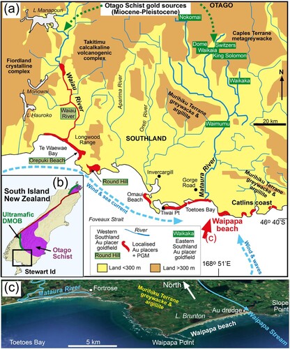
Figure 1. Location of Waipapa beach in southern New Zealand. (a) Generalised topographic and geological map of the Southland area, showing the principal goldfields of Western Southland and Eastern Southland with gold derived ultimately from Otago Schist. Locations of placers with both gold and platinum (PGM) are indicated in red. (b) Regional geological setting in the South Island. (c) Oblique aerial view (from GoogleEarth) of Waipapa beach and adjacent coastline.
In this study, we take advantage of this active and dynamic environment to define the key features, and time scales within the last century, of aeolian gold concentration that are relevant to older and more complex aeolian sites elsewhere in the world. The principal modes of gold concentration at this site are wind-driven during sand dune formation and erosion. This study incorporates, and distinguishes, observations on aeolian processes that lead to morphological modification of gold particles (Nikiforova Citation2021; Palmer and Craw Citation2024a) versus aeolian processes that concentrate gold particles (Dill and Buzatu Citation2022), with a particular focus on the latter processes.
At the Waipapa beach location for this study, strong winds dominate the surface environment (Supp. Figure S1) and aeolian concentration has been the most widespread and effective process for gold enrichment. The studied beach has been the site of several historic mining operations, culminating in a large dredge in the 1930s (c; PGM Citation1986; Papers Past Citation2024), but there has been no previous research on the nature of the gold and its distribution in this area. Like typical beach gold around the world, the material we describe is finely particulate (<200 µm) and difficult to sample (Boyle Citation1979; Eyles Citation1990; Craw and Kerr Citation2021; Kungurova Citation2021; Nikiforova Citation2021; Palmer et al. Citation2024). Despite this difficulty, we have traced gold concentration and redistribution through a range of active and young (Pleistocene to late Holocene) beach environments, assisted by prominent associated black sand accumulations.
Detrital gold can travel for long distances, up to hundreds of kilometres, in sedimentary systems, resulting in complex transport histories (Boyle Citation1979; Youngson and Craw Citation1999; Townley et al. Citation2003; Garnett and Bassett Citation2005; Chapman, Moles, et al. Citation2022; Chapman, Craw, et al. Citation2022; Palmer et al. Citation2024). Unravelling a complex transport history based on various characteristics of gold particles is therefore fraught with difficulty, although many attempts have been made at such quantification (e.g. Knight et al. Citation1999; Youngson and Craw Citation1999; Townley et al. Citation2003; Chapman et al. Citation2011, Citation2021; Chapman, Moles, et al. Citation2022; Nikiforova Citation2021). In this study, we contribute to this type of study by using morphological and mineralogical evidence to infer sources and transport pathways for the Waipapa beach gold.
General setting
Waipapa beach environment
Waipapa beach is the largest sandy beach along the Catlins coast to the east of the Mataura River mouth (a,c; Supp. Fig. S2–S7). The western end of the beach is defined by two prominent reefs of Murihiku Terrane basement rocks, and the eastern end of the beach abuts Murihiku Terrane basement rocks that form most of the Catlins coast farther east (b,c). The immediate hinterland of the beach is an extensive low-lying area of pools, lakes, wetlands and dune fields with only minor drainage across the beach (c and a; Supp. Fig. S2–S7). The largest wetland area occurs around Lake Brunton that abuts and periodically discharges across, the central portion of the beach (c). The dune fields adjacent to the beach were historically largely unvegetated, but now have become stabilised by abundant vegetation cover (c and a,b). Waipapa Stream is the only significant drainage system, with a catchment that extends from ∼10 km inland and discharges across the eastern end of the beach between the beach sands and the basement rocks (c). The lower part of this catchment has also been dominated by unvegetated sand at times historically, but is now largely vegetated (c).
The general climate is cool temperate with frequent rain events throughout the year and mean annual temperature of ∼10°C (NIWA Citation2024). The meteorological setting is dominated by Foveaux Strait winds that are almost constant, with few windless hours (Supp, Fig. S1). Wind data for this study were obtained for Tiwai Point weather station (NIWA Citation2024) which is in a similarly exposed site on the coast ∼20 km to the west (a) and provides a useful proxy for Waipapa beach. The prevailing wind is from the west (Supplementary Fig. S1), sub-parallel to Waipapa beach, which results in an environment of almost perpetual blowing sand on exposed tidal and storm beach areas and dunes (a–c). Winds of 10–50 km/h are common on an hourly basis (Supp. Fig. S1). Maximum daily gusts of 20–50 km/h are the norm, and westerly winds with gusts of 50–150 km/h are common (Supp. Fig. S1). Winds from the southerly quarter are also common, although less strong (Supp. Fig. S1). These southerly winds contribute to driving on-shore waves that arrive from Southern Ocean swells that are diverted around eastern Stewart Island (a–c).
Regional detrital gold and platinum
Orogenic and paleoplacer gold deposits sourced from the Otago Schist (a,b) have been the predominant, possibly only, contributors to detrital gold in Southland through the Cenozoic history of the area (Williams Citation1974; Craw and Kerr Citation2021; Craw, Kerr, Falconer, Citation2015; Craw, Kerr, Reith, et al. Citation2015; Upton and Craw Citation2016; Palmer et al. Citation2024). Small gold-bearing veins in the Longwood Range (a; Williams Citation1974) may have provided a minor component of Southland detrital gold. Erosion of the Longwood Range may also have contributed a small amount of detrital platinum (Williams Citation1974; Ashley et al. Citation2012), but most detrital platinum was probably derived from ultramafic rocks in the Dun Mountain Ophiolite Belt immediately southwest of the Otago Schist (b; Craw and Kerr Citation2021).
These various sources shed detrital gold and platinum into river systems that have had a complex history of drainage reconfigurations since the area emerged from below sea level in the late Oligocene (Turnbull and Allibone Citation2003; Stein et al. Citation2011; Upton and Craw Citation2016; Craw et al. Citation2024). The most abundant post-Miocene detrital gold occurs in what is now the Mataura River catchment, constituting the Eastern Southland goldfield (a; Williams Citation1974; Craw, Kerr, Reith, et al. Citation2015; McLachlan et al. Citation2018). This area has been the focus of most historic and modern gold mining in Southland (Williams Citation1974; Craw, Kerr, Reith, et al. Citation2015; Craw et al. Citation2024; McLachlan et al. Citation2018). No platinum has been detected in Eastern Southland goldfield, despite abundant opportunities for observation and collection during this widespread mining history (Williams Citation1974; Craw, Kerr, Falconer, Citation2015; McLachlan et al. Citation2018). Chromite that may have been derived from the Dun Mountain Ophiolite Belt occurs in both the Waikaka and Waimumu paleoplacer goldfields, but platinum is conspicuous by its absence in mine concentrates from these mining areas (Craw, Kerr, Falconer, Citation2015; Craw et al. Citation2024).
The Western Southland goldfield has been focused on the Waiau River and the coastline near its mouth (a), with most modern and historic mining occurring in Pleistocene beach deposits near Round Hill (a; Williams Citation1974; Turnbull and Allibone Citation2003; Craw and Kerr Citation2021; Craw, Kerr, Reith, et al. Citation2015; Palmer and Craw Citation2024a, Citation2024b, Citation2024c). Detrital platinum occurs with gold in the Waiau valley and along the coast (a; Craw and Kerr Citation2021). Pleistocene glaciers from Fiordland obscured the fluvial sedimentary history of the Waiau valley, and most modern detrital gold and platinum are shed from moraines south of Lake Manapouri (a; Turnbull and Allibone Citation2003; Craw and Kerr Citation2021; Craw, Kerr, Reith, et al. Citation2015).
Methods
Sand deposits at Waipapa beach (as outlined below) were examined in the field for locations and extents of black sand in which detrital gold has also been concentrated. These were further investigated by shallow excavations with a trowel to expose black sand layering and its relationships to other surface features and associated dunes. On a larger scale, the development of the various sand deposits on decadal time scales was examined over time by comparing historical aerial photographs from Retrolens.co.nz with Google Earth (2023 images). The best-resolved historical photographs were from 1948 (Run 1597, photos 3,5,7,9), and these were used as baseline (e.g. a) for comparison to modern (Google Earth, 2023) images at selected portions of the beach (Supplementary Fig. S4, S6, S7). Some 1994 and 2002 images from Environment Southland (maps.es.govt.nz/apps/historic-imagery/photos) were also useful for comparison. Shorter-term (years) changes in the beach environment were documented from the comparison of sequences of recent (since 1994) aerial images from the same sources.
Detrital gold samples were collected with well-cleaned plastic gold pans, with most sample concentrations done on the beach in a water-filled plastic bin. The gold is finely particulate and floats readily on water surface tension, so drops of detergent were added to limit this issue. Samples were collected from black sand concentrates in a range of topographic settings on the beach, dunes, and the Waipapa Stream. Most pan samples contained 5–20 gold particles. Concentrated gold samples with residual heavy minerals were kept in the pans and taken to a laboratory bench for final concentration. Gold in dried pans was further concentrated by sweeping across the pan with the frayed end of a wooden toothpick under a stereoscopic microscope. The fine flaky particles were remarkably difficult to manipulate as they adhered to all surfaces, possibly via electrostatic attraction, and most particles were moved with considerable difficulty. Nevertheless, the soft wood of the toothpick did not deform gold particle surfaces that were to be examined in detail in this study.
Clusters of particles were mounted on to one-centimetre aluminium stubs covered in double-sided carbon tape by inverting the stubs into the bottom of the pan. The resultant stubs hosted some residual black sand as well as gold. These mounted stubs were photographed with a stereoscopic light microscope, along with some residual particles in the pans. The stubs were then used for scanning electron microscopic (SEM) examination. Observations of the mounted stubs were made on a Zeiss Sigma VP (variable pressure) scanning electron microscope (SEM) at the Otago Micro and Nanoscale Imaging (OMNI) (University of Otago, New Zealand). The samples were not carbon coated, and low-pressure nitrogen gas was used in the instrument to limit charging on non-conductive material. Backscatter electron images (BEI) of particles were obtained at 15 kV. Semiquantitative spot analyses (3 µm beam) were obtained via energy-dispersive spectrometry (EDX), although these were limited in accuracy and precision by rough surfaces, the small sizes of some targets, and high background resulting from the adjacent black sand residues. Automated element mapping was done to obtain an estimate of relative proportions of magnetite and ilmenite in these residues, and this mapping was also hindered by high background, especially for Fe and Ti.
Results
Sand deposits at Waipapa beach
Quartz-rich sediments have been arriving at Waipapa beach since the Pleistocene, resulting in a constant supply of fresh and recycled sand (c and a–e; Supp. Fig. S2–S7). In this windy and surf-erosional setting, sand deposits are ephemeral so detailed mapping is not useful. Instead, we have defined a range of deposits on the basis of relative ages and topographic expressions, within the context of this dynamic coastal environment. All dunes, streams and beach deposits have been at least partially built from sand eroded from older dunes and the Pleistocene littoral sediments (a–e). The active storm beach truncates and locally erodes dune fields that were built through the Holocene on top of Pleistocene littoral sediments (d). These latter deposits are dominated by beach sands with varying amounts of organic material and scattered pebbles and cobbles, resting locally on soft but coherent mudstone (Supp. Fig. S4).
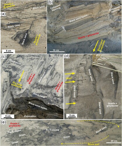
Figure 2. Waipapa beach erosion that contributes to black sand concentrates in a range of geological and geomorphological settings. (a) Aerial view of the western end of the beach in 1948 (from Retrolens.co.nz), showing abundant active dunes that have since been eroded to leave a scarp exposing underlying Pleistocene beach deposits (Supp. Figure S4). Inset is a close view from a 1994 aerial photo (Environment Southland) of the indicated beach margin (yellow line in a) showing an incipient erosional step. (b) Beach view towards the west during a light wind (estimated ∼10 km/h) with actively blowing sand (white). Remnants of storm-driven black sand concentrates are being eroded by blowing sand. (c) Reconcentration of black sand in the turbulence of active surf. (d) Black sand in Millennial and active dunes formed against the eroded scarp in Pleistocene sediments. (e) Excavated section through the contact between eroded scarp of Pleistocene sediments and a Millennial dune with numerous black sand layers truncated by surficial avalanche deposits with new black sand layers.
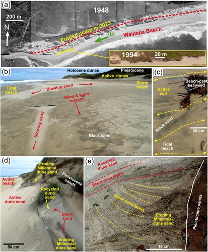
Holocene dunes and Pleistocene littoral sediments are being actively eroded by storm waves at the western end of the beach to form a prominent scarp up to 10 m high (a,d). Incipient development of this scarp had begun by 1994 (a inset). Lateral erosion of ∼60 m since at least 1985 and probably since 1994, suggests a coastal retreat rate of >1 m/year on this section of the beach (a). Blowing sand has formed dunes up to 5 m high against the eroded scarp since it developed after 1985–1994 (a,b,d). The oldest portions of these dunes against the eroded scarp are herein called Millennial dunes (d and ) after the human demographic cohort of similar vintage. Sand within these Millennial dunes is firmly compacted and the dunes have locally prominent exposures, against the eroded scarp, that are presently being eroded by wind-blown sand and storm waves (d and a–d; Supp. Fig. S5). Millennial dunes have been modified, enhanced and partially eroded on yearly time scales throughout their history (a–e; Supp. Fig. S6). These Millennial dunes are distinguished herein from the rest of the Holocene dunes that for the purposes of this study we terminate in 1985. Still, younger dunes are actively forming and reforming on daily, weekly or monthly time scales against the eroded scarp, against the Millennial dunes, and on the Holocene dunes (b,d,e and ).
Figure 3. Time sequence of aerial views of the eastern end of Waipapa beach, between 1994 and 2020 (from Environment Southland and Google Earth, all at similar scale) showing the short-term evolution of Waipapa Stream outlet through the dune field near the historic dredge site. White sand covers vegetation after a major wind event in 2011. The present stream outlet (red arrows) has taken over from an old outlet (yellow dashed arrows) and a triangle of Millennial dunes increased in height between these outlets from 2005 to 2018. These dunes contain aeolian black sand and gold concentrates (f; Supp. Fig. S5, S7). That Millennial dune field has since been shrinking slightly (2020 image and 2023 in b).
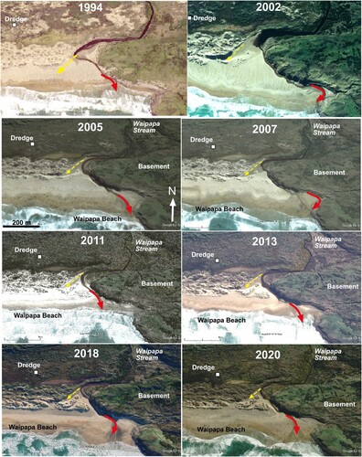
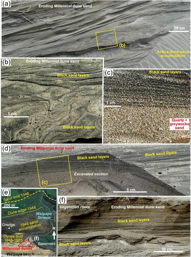
Figure 4. Aeolian black sand concentrates in eroding Millennial Waipapa beach dunes. (a) Dune cross-bedding exposed by differential wind erosion at the base of the cliff at the west end of the beach. (b) Aeolian depositional black sand layers in the dune in a, with exposed patterns caused by differential erosion. (c) Close view of excavated aeolian depositional black sand layers that have amalgamated (top) above dune sand with few heavy minerals (bottom). (d) Excavated zone of aeolian depositional black sand layers, showing the location of view in c. (e) Map view of the east end of the beach (Google Earth 2003) showing different sand ages and location of Millennial dunes (formed 1994–2011). (f) Wind-eroded cliff in Millennial dunes in e, showing dark black sand layers in dune bedding.
At the eastern end of the beach near Waipapa Stream (c), Holocene and active dunes have been accumulating sand with on-going redistribution adjacent to and beyond the storm beach right through to the present (; Supp. Fig. 7). A separate small area (∼ 200 m across) of Millennial dunes has formed at the mouth of Waipapa Stream (c, , and e,f). These dunes have developed progressively on a portion of the former fluvially dominated tidal delta since 1994, with the most active growth occurring between 2002 and 2011 ( and e,f). These Millennial dunes are free-standing, up to 10 m high, and hence are taller and have different morphology from the Millennial dunes formed against the erosion scarp at the western end of the beach (d and ). The Millennial dunes at the stream mouth have been partially vegetated, although storm wave, wind and stream incisions are eroding parts of these dunes ( and e,f).
Farther upstream in the Waipapa Stream catchment, abundant sand had accumulated and coated the landscape up to 1 km from the beach (c and e). The remnants of a historic gold dredge upstream of the Waipapa Stream delta (c) were largely buried by 1948 by blowing sand in the Holocene dunes in which it had been working, and that sand remained to the 1980s ( and e). Modified forms of these dunes still persist in the area around the dredge, although the dunes are now extensively vegetated and partially stabilised ( and e; Supp. Fig. S7). Reworking of dune sands in this eastern area by the Waipapa Stream is an on-going process (Supp. Fig. S7).
In the central portion of the beach near Lake Brunton (c), between the eroding western end and the sand accumulation areas at the eastern end, the edge of dune fields adjacent to the storm beach has undergone only minor changes in position since 1948 (a; Supp. Fig. S3). Pleistocene sediments, if still present, are completely covered by Holocene and active dunes and no erosional scarp has formed (a), so the distinction of Millennial dunes is not possible in most of the dune field. Between the Lake Brunton area and Waipapa Stream catchment, there has been pronounced progradation of the edge of the dune field towards the beach since 1948 (∼200 m; e; Supp. Fig. S3). Dune field progradation had been initiated by 1948 as a large area of wind-blown sand on the storm beach (e). This area of accumulating sand on the 1948 beach merged eastwards with the even more extensive sand accumulation in the Waipapa Stream catchment (e). These post-1948 dunes are now extensively vegetated, although a narrow (∼100 m wide) belt of active dunes persists ( and e).
Black sand deposits in dunes
Aeolian black sand layers are abundant in many of the Holocene and Millennial dunes and some active dunes at Waipapa Beach and constitute the principal repository for black sand at the beach. We focus our descriptions on the black sand in Millennial dunes as these have the best outcrop exposures (d,e and a–d; Supp. Fig. S5), although similar features can be seen in many Holocene dunes as well. In addition, the approximate ages of Millennial dunes are known from their topographic settings within the context of available aerial photography (a,d, and e). Hence, the time scales of the formation of black sand concentrates within those dunes can be quantified (). These observations demonstrate that accumulations of black sand layers can form and reform within a year, and substantial accumulations of black sand layers in larger dunes can form in less than ten years (d,e, and a–f).
An example showing time scales of Millennial dune development and modification at the western end of Waipapa beach occurred between 2012 and 2023 (as documented in images in Supp. Fig. S6). Storm waves had traversed the whole storm beach in 2012, leaving remnants of Millennial dunes at the foot of the cliff. A substantial coating of new Millennial dunes then developed immediately prior to January 2018 over the whole of the storm beach (20–40 m wide) downslope of the erosional cliff. Westerly winds at the time of dune development were strong but not abnormally so (Supp. Fig. 1), and storm waves were apparently relatively restrained so that the wide dune field could build up. By December 2018, these Millennial dunes had largely been eroded by subsequent storm waves, leaving a residue of black sand on the storm beach. By 2021, this black sand residue was almost gone, and it was completely absent in 2023. Remnants of Millennial dunes containing aeolian black sand concentrations persisted at the base of the cliff through these processes, and some of those Millennial dunes were still present during 2024 field work for this study (cf a,d and a–d).
The black sand layers in Millennial dunes range in thickness from <1 to ∼10 mm (b,d), with the thicker layers generally resulting from the amalgamation of numerous thin layers (c). The layers define cross-bedding within the dunes and are truncated at low angles by overlying beds on the 10–30 cm scale (a,b). Layers vary in thickness laterally from near-zero to >10 mm on the 10 cm scale (e.g. right side d). Differential erosion of compacted dune sands yields complex patterns of black sand distribution on remnant exposed bedding surfaces (a,b).
Dune surfaces exposed to sun and wind lose the coherence associated with original wind compaction, and the external 2-10 cm zone forms a loose sand coating to dune surfaces. This sand, at an angle of repose on eroding dunes, cascades down the dune slopes in small (metre scale) sand flows or sand avalanches (referred to as avalanches herein). These avalanches disrupt the aeolian depositional black sand layering, and density-driven sorting in the recycled sand creates new black sand concentrations on the avalanching surfaces (e and a–c; Supp. Fig. S3). The initial stages of this surficial recycling can involve the collapse of the depositional layering in internally coherent blocks at the 1–10 cm scale, but these blocks soon disintegrate and most of the avalanches have no coherence (a–c). Loading of dune surfaces with actively blowing sand can trigger these avalanches, and small avalanches were observed every few minutes at times during this field work. The end result of this avalanching process is a surficial zone with black sand layers sub-parallel to the surface and truncating the original depositional layering (e and c). From the mechanistic perspective, this gravity-driven (down-hill) layering is distinctly different from the aeolian depositional layering that was formed as wind blew sands up-hill.
Figure 5. Black sand concentrates formed by active surficial recycling at Waipapa beach. (a) Wind erosion of a Millennial dune (top) is disrupting and recycling black sand into a surficial down-slope avalanche of black sand on active dune sand. (b) Eroded face of a Millennial dune with aeolian black sand layers that are locally collapsing with coherent blocks (left and right). The blocks have disintegrated at the bottom of the image into down-slope avalanches. (c) Close view of the avalanching surface of a Millennial dune, excavated at the base, showing differential sorting to create new black sand layers sub-parallel to the avalanching surface. (d) Actively blowing dune sand, with black sand accumulating on the windward side (left) of blades of grass. (e) Irregular accumulations of heavy minerals (sorted into black and green portions) on the storm beach where storm waves have eroded black sand layers from dunes immediately up-slope.
Not all dunes contain the abundant black sand layers described above, as there is differential aeolian transport of sands of contrasting density that is controlled by wind velocity. Blowing sand observed during field work was almost entirely devoid of a black sand component despite the presence of surficial black sand on the beach (e.g. b). In these relatively light winds (<20 km/h), any black sand that was mobilised became concentrated behind even small (mm-scale) obstructions, creating ephemeral residual concentrations (a,d). As a consequence of this differential mobilisation of sand, some of the active dunes were found on excavation to contain no black sand concentrations and only minor heavy mineral components (e.g. d and a).
All the above concentration sites of black sand in dunes can be recycled by the surf on to the storm beach and the active tidal beach, and localised deposits of black sand on the beach attest to this recycling process (b,c and e). These surf-driven beach accumulations of black sand typically occur immediately downslope of dunes with abundant exposed black sand layers and have apparently been eroded from these dunes (Supp. Fig. S6). Hence, parts of the tidal and storm beach are devoid of surficial black sand. Further, excavation of tidal beach sands only rarely reveals buried black sand layers. These observations suggest that the surf concentration of black sand is volumetrically minor compared to aeolian concentration processes described above. This situation contrasts strongly with that observed on beaches near the Waiau River mouth to the west (a), where surf concentration of black sand is a daily occurrence and aeolian concentration processes are minor (Craw, Kerr, Reith, et al. Citation2015).
Recycling of Pleistocene sediments
Storm erosion of the Pleistocene littoral sediments at the western end of Waipapa beach (a,b,d) contributes a recycled component of sediment, and apparently gold-bearing black sand, to the younger dunes and beach deposits, typically with brown staining (a–h; Supp. Fig. S4). Most of the Pleistocene-derived sand clasts are distinctive because of their coating films of brown ferric iron oxyhydroxide (a,c,d). This staining is less prevalent in some of the organic-rich Pleistocene beds, but is nevertheless still present. Staining extends to the formation of cement in some parts of the Pleistocene sands (d), and cm-scale veins cut across some outcrops in the eroded scarp.
Figure 6. Pleistocene sands are recycled into Holocene and Millennial dunes, and active beaches. (a) Microscope view of quartz-dominated white blowing sand on the beach, showing a combination of white quartz and brown-stained quartz recycled from Pleistocene sands. (b) Gold from black sand on storm beach immediately downslope of eroded scarp in Pleistocene sediments and Holocene dunes. (c) Microscope view of Pleistocene sand, showing brown-stained quartz, scattered greywacke, argillite and Fe–Ti oxide clasts (dark) and minor green heavy minerals. (d) Excavated contact between Pleistocene sand and a Millennial dune blown against the eroded scarp, showing abundant cementation of Pleistocene sand by ferric oxyhydroxide. (d) Excavated unconformity between Pleistocene sand (brown) and Holocene dune sand (white), with a Holocene cm scale black sand layer resting on the unconformity. (f) Gold-bearing heavy mineral concentrate from the black sand layer in e. (g) Largely oxidised authigenic pyrite clast from black sand layer in e. (h) Detrital gold particle from Pleistocene sand from a sample taken near to e.
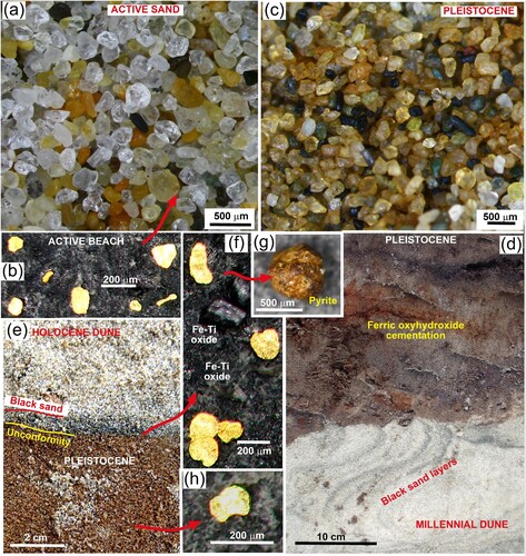
No black sand layers were seen within the Pleistocene sands in this study, although the abundant localised cementation may have obscured such layers in places. Likewise, the abundant organic material in some sand layers may also have obscured any black sand concentrations. Heavy minerals, including the Fe–Ti oxides that dominate black sands elsewhere at the beach, are distributed throughout the Pleistocene sands (c). A well-defined Holocene black sand layer resting directly on Pleistocene sand (e) has been at least partially recycled directly from the underlying sand, and this layer contained Fe–Ti oxides and coarse pyrite pseudomorphs (f,g). Hence, at least some of the abundant ferric iron oxyhydroxide stains, cement and veins in the Pleistocene sediments are presumed to have been derived from oxidation of authigenic pyrite.
Rare flaky gold occurs dispersed in the Pleistocene sand (h), and abundant flaky gold was extracted from the black sand layer resting directly on Pleistocene sand (e,f). Recycling of gold and other heavy minerals in the Pleistocene sands as the eroded scarp develops (a) contributes to the black sand deposits elsewhere on the beach and dunes (Supp. Fig. S6).
Fluvial recycling of black sand
Waipapa Stream at the eastern end of the beach is constantly reworking dune sands even at times of low flow, as it discharges from the hinterland through the dune fields to a broad tidal delta on the tidal beach ( and a–d; Supp. Fig. S7). Black sand concentrates and associated gold are re-concentrated by fluvial processes in a range of sites along the stream during this sand recycling (a–f). The tidal delta on the beach is the largest single area for this recycling, extending for ∼200 m downstream from the dune field in a zone of ephemeral channels ∼100 m wide (a). Bedded sands, including mm-cm scale black sand layers, are deposited across the storm beach by the stream during high flow periods, and these deposits are in turn recycled into active channels by bank erosion and tidal activity (a,b). The black sand is re-concentrated on the active channel beds in deposits along the stream margin and in ripple depressions on the bottom of the channel (a).
Figure 7. Waipapa Stream fluvial sediments and black sand concentrations. (a) Tidal delta on Waipapa beach, looking upstream, showing black sand layers. (b) Close view of collapsing stream bank in a, with black sand layers being recycled into the active stream. (c) Black sand concentrates formed where the stream is eroding a Millennial dune (as in ). (d) Small-scale black sand concentrates in centres of erosional channels in the eroding bank of Waipapa Stream. (e) Compilation of images of detrital gold and one particle of platinum from black sand in Waipapa Stream (as in c), all at the same scale showing a wide range of particle sizes. The smallest particle is circled at centre right. The particle on the lower right may be toroidal (cf j). (f) Flake from the same sample as (e), mounted obliquely (slope down to lower right) to show the 10 µm rim thickness (extra small scale bar added).
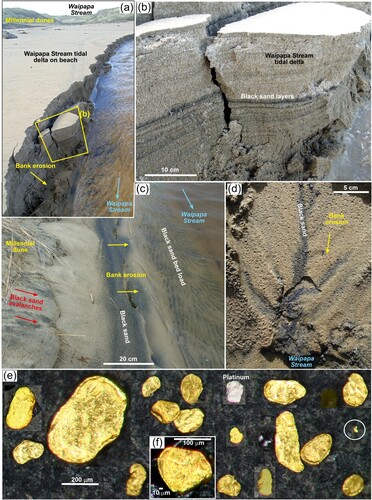
Similar fluvial black sand concentrations develop in the stream channel farther upstream in the dune field, where bank erosion of dune sand avalanches and aeolian concentrations are re-concentrated fluvially (c,d). Concentrations of black sand occur along the stream bank where they have been deposited by flowing water with fluctuating levels (c,d). Black sand migrates downstream on the stream bed where concentrates develop in ripple depressions and channel thalwegs (c,d). The stream channel through the dune field migrates laterally as dune sands are eroded into the bed (), with fluvial sand bars forming and eroding on an annual basis. The eroding stream bank in c (2024) was a broad sand bar in previous years (). These fluvial migration processes locally re-concentrate black sand or transport it to the tidal delta on the beach. Black sand layers are common in the Millennial dunes and active surficial zones of the dune field near the stream, indicating that aeolian processes are returning black sand from the beach to the dune field (; Supp. Fig. S5, S7).
Black sand mineralogy
Gold is a minor component of the black sand at all sites examined in this study, occurring in the fine or very fine sand fraction (e.g. b,f and e). Gold accompanies Fe–Ti oxides in the black sand along with rare platinum (a–c). Gold is primarily flaky in shape, with flake sizes typically ranging from ∼500 µm (rare) to ∼50 µm, with most flakes being about 100–200 µm across (b,f and e). However, the observed gold particle size is at least partially a result of limitations of gold panning as a separation technique, as finely particulate floating gold is a constant problem in field and laboratory (c). Occasional finer gold particles were observed in samples (e.g. e) but these were extremely difficult to extract from the gold pans. Platinum is also flaky or rounded in shape and of similar particle size to the gold (b), but this too may be a consequence of sampling bias.
Figure 8. Mineralogy of black sand at Waipapa beach. (a) Pan concentrate showing separation of the more dense Fe–Ti oxides from the green heavy mineral component (right). Garnets (pink and red) occur in both fractions. (b) Detrital platinum minerals. (c) A raft of Fe–Ti oxides with entrained gold (Au), floating on water in a pan concentrate. (d) Composite EDX element map of black sand concentrate with Fe (green) and Ti (red) superimposed on a backscatter electron image. Gold is white with red and green dots indicating the background. (e) Close view of concentrate showing principal minerals: A = apatite; G = garnet; P = pumpellyite; Z = zircon. (f) Garnet compositions from beaches on the Catlins coast (Mitchell Citation1996) quantifying the red (Fiordland) and pink (Otago) garnet sources in e. (g, h) Backscatter electron images of two chromite particles visible (via Fe signal) in d.
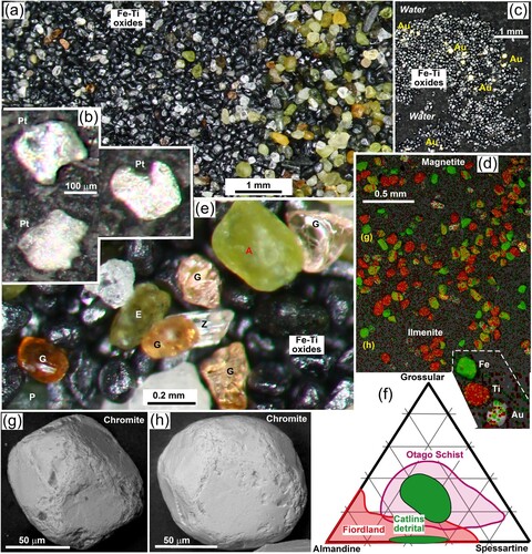
The black sand heavy mineral concentrate layers consist of two distinct components that are mixed in most layers: black Fe–Ti oxides, and green heavy minerals apatite, epidote, and pumpellyite-rich clasts (a,e). These two components readily separate during surficial dune avalanching, surf-driven beach reworking, and during gold pan concentration (e and a). The Fe–Ti oxide particles are approximately half magnetite and half ilmenite, with some of the magnetite containing detectable Ti (d). Particles of Fe–Ti oxides are mostly well rounded, but remnants of crystal shapes remain on some particles. The green mineral component of the black sand typically contains abundant zircons and scattered garnets that are mostly pale pink, with a minor component of deeper red garnets (e). Analysis of the two garnet types (Mitchell Citation1996) suggests that the common paler garnets have an Otago Schist origin whereas the dark red garnets have a Fiordland origin (f). Chromite is a rare contributor to the Fe–Ti oxide component of the black sand (d,g,h). These particles are rounded like the Fe–Ti oxides that they accompany (d), but one chromite particle was observed to have remnants of crystal form (g).
Gold morphology
Gold flakes have a wide range of detailed morphological features, as indicated by SEM backscatter images (a–e and a–g). The flakes are typically only ∼10 µm thick (f, a–d and a,b). Most flakes have some evidence of thickened rims around all or part of the particles (e and a–c). These rims have been partially enhanced in many particles by distinct folds of parts of the flakes (a,d,e), and the fold in e almost doubles the thickness of the particle. Most flakes have extensive evidence of surface smearing caused by deformation during transport (a,b,d–h). These smears dominate the surface morphology of most flakes at the 1–10 µm scales, especially on the rims (a,b,d–g). Smears have a wide range of orientations in close proximity, and smears with the same and differing orientations are locally imposed on top of one another (d–g).
Figure 9. Backscatter electron images showing the morphology of detrital gold particles from a Millennial dune at Waipapa beach. (a–e) Variably flattened and fold flakes. (f–i) Irregularly shaped fine particles. (j–l) Particles with toroidal morphology (see text).
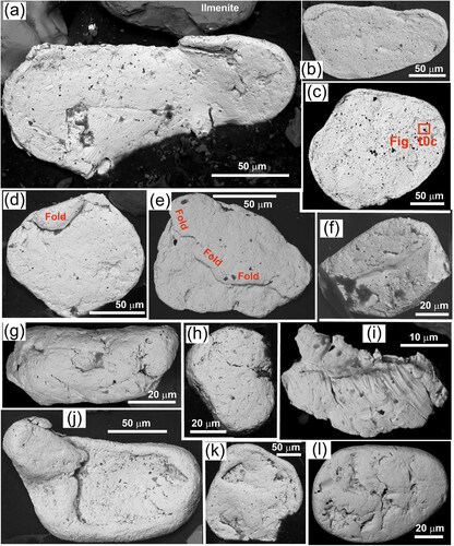
Figure 10. Backscatter electron images of detrital gold particle surface and deformation textures from a Millenial dune at Waipapa beach. (a,b) Edge view of a flake, showing the thin structure and smeared marginal overhang. (c) Close view of a little-deformed portion of a flake surface (as in c) showing straight-sided voids that may reflect primary textures. (d-h) Views of variably smeared particle surfaces, with different smear directions indicated with red arrows.
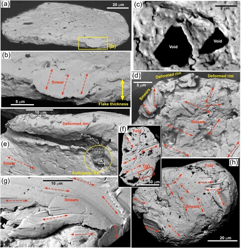
Within the flat parts of many flakes, between smears, there are numerous micron-scale pits and depressions (a–c), some of which are filled with silicate minerals, mostly quartz or feldspar. The shapes of a few of these depressions have straight sides that may reflect original quartz crystal outlines (c and c). However, most such depressions are more irregular and may have been formed by impact and forced inclusion of silicate clasts during transport, associated with the extensive smearing. However, smears also appear to cover over some of the depressions and associated inclusions (d,f–h).
The smallest gold particles are typically less flaky in shape (f–i). Rare particles have sharp outlines with comparatively little evidence of rounding (f). However, most small particles are well rounded with ellipsoidal shapes (g,h and h). One very small particle has ragged edges and surficial evidence of intense deformation (i) and may have been broken from a deformed rim protrusion of a larger particle during transport (e.g. a and d,e).
A small subset of gold particles has smooth surfaces without smears, and these particles have greatly thickened rims that create dish-shaped forms (j). More advanced rim development has led to near-complete overlapping of extended rims on to the dish-shaped central portions of the particles (k,l). These latter particles also have smooth unsmeared surfaces (k,l). The extended rims of particles in k,l partially or fully cover and incorporate silicate coatings and inclusions into the structure of the particles (j–l). These particles are distinctly different from the flakes that dominate the gold population (e.g. e and a–e), and strongly resemble the toroidal gold that occurs on beaches farther west along the coast (see Discussion below).
Authigenic minerals
Several gold flakes have vermiform authigenic gold overgrowths in cavities within the particles (e and a,b). These delicate overgrowths have been preserved, or lately formed, in sites that have been protected from deformation that has occurred elsewhere in the particles, especially under folded rims (e and a,b; Supp. Fig. S8). The vermiform gold is intimately intergrown with clay minerals, and some of the gold forms micron or sub-micron-scale spots within the clay. In addition, delicate micron and sub-micron-scale authigenic gold adheres to silicates, especially clay and pumpellyite (c–f). These latter occurrences mainly occur as isolated irregular spots and coatings on their silicate substrates (d–f).
Figure 11. Authigenic minerals from black sand in a Millennial dune at Waipapa beach. (a,b) Vermiform authigenic gold in an undeformed crevice of a flake. (c) Irregular and delicately shaped authigenic gold (left, white) adhering to a particle of clay (right, nearly electron-transparent). (d–f) Micron-scale authigenic gold (white; some in yellow circles) coating pumpellyite clasts (grey) and associated clay (nearly electron-transparent). (g,h) Authigenic silver sulphide crystals (acanthite?) adhering to a particle of ilmenite (top left in g). Minor coating mineral (brighter white in h) is an Ag-sulphate mineral (Supp. Fig. S8, S9).
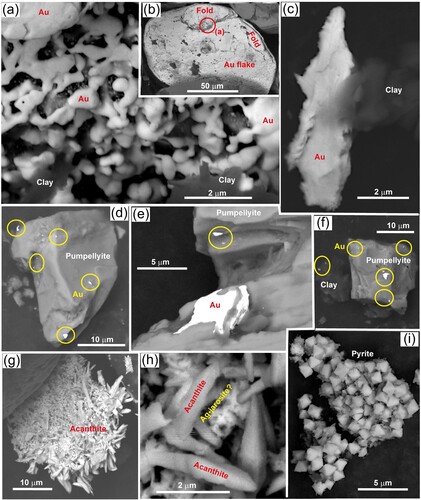
One cluster of delicate silver-bearing authigenic crystals was attached to a particle of ilmenite ( g,h). These crystals contain sulphur, and there are apparently two different Ag–S bearing minerals in the cluster ( g,h; Supp. Fig. S9). The crystals are too small for precise analysis via EDX, and there is considerable interference in EDX spectra from nearby ilmenite. Tentative identification of the dominant crystal clusters suggests that they are a sulphide mineral, possibly acanthite (Ag2S). Some crystalline authigenic pyrite occurs in the heavy mineral concentrates as well (i), so a sulphide-producing environment has been present. The possible acanthite crystals have a coating of an oxidation product with distinctly higher oxygen peak in the EDX spectrum, above the ilmenite-driven background. We tentatively interpret this to be a sulphate mineral (Supp. Fig. S8, S9).
Discussion
Gold transport pathways
The abundance of quartz sand at Waipapa beach reflects its close proximity to the lower reaches of the Mataura River (a,c; Supp. Fig. S10), which carries abundant quartz-rich sediment and has done since the Miocene (Stein et al. Citation2011; Craw, Kerr, Falconer, et al. Citation2015, Citation2024). This quartz-rich sediment was originally derived from the Otago Schist, although direct fluvial connections no longer exist (Craw, Kerr, and Falconer, Citation2015; Craw et al. Citation2024; Palmer and Craw Citation2024b). However, extensive Pliocene and Pleistocene quartz-rich sediments are found throughout the lower Mataura catchment as erosional remnants and river terraces (Supp. Fig. S10; Turnbull and Allibone Citation2003; Stein et al. Citation2011; Craw, Kerr, Falconer, et al. Citation2015; Craw et al. Citation2024), and these are being actively eroded throughout the modern river catchment. The presence of pale pink Otago Schist garnets in the beach sediments (e,f) also supports an original Otago source for the sands, as does the abundance of the green metamorphic minerals epidote and pumpellyite. The exact pathway for this sediment to reach Waipapa beach is not clear: there may have been a component of modern Mataura River sediment reaching the beach (cf Hicks et al. Citation2011), and there may have been a component being washed onshore from Pleistocene Mataura fluvial deposits in Foveaux Strait formed at times of lower sea levels (cf. Cullen Citation1967).
The presence of detrital platinum on Waipapa beach (b; PGM Citation1986) is an important indicator of sediment derivation from what is now the Waiau catchment to the west (a). Platinum is not known to occur in what is now the Mataura catchment, despite extensive mining over >100 years in Eastern Southland goldfield (Williams Citation1974; Craw, Kerr, Falconer, et al. Citation2015; Craw et al. Citation2024; McLachlan et al. Citation2018). The last gold dredge at Waipapa beach reputedly produced ∼24 ounces (∼0.74 kg) of platinum between 1935 and 1937 (PGM Citation1986). Eastward transport of the platinum may have occurred via longshore drift along the present coastline, as implied by its presence on most beaches between the Waiau River mouth and the Catlins coast (a). Alternatively, there may have been eastward sediment migration on the shallow floor of Foveaux Strait during low Pleistocene sea levels (Cullen Citation1967), followed by modern on-shore reworking by waves (a and a). Rare but distinctive toroidal gold at Waipapa beach (j–l) is also likely to have been derived from the west with the platinum that co-occurs with toroids in the Western Southland goldfield (Supp. Fig. S11; Craw et al. Citation2013; Craw, Kerr, Falconer, et al. Citation2015; Craw and Kerr Citation2021; Palmer and Craw Citation2024a, Citation2024b, Citation2024c). Red garnets derived from Fiordland (e,f) are another possible indicator of sediment passage eastwards along Foveaux Strait. However, Fiordland garnets also occur in late Cenozoic sediments in eastern Southland as a result of coastal transport at times of high relative sea level earlier in the Cenozoic (Stein et al. Citation2011; Craw, Kerr, Falconer, et al. Citation2015). Similarly, detrital chromite occurs in the Waiau River system, but chromite is also abundant in Pliocene sediments in the Eastern Southland goldfield (Craw, Kerr, Falconer, et al. Citation2015; Craw et al. Citation2024) and is therefore not definitive.
The flaky morphology of most of the gold at Waipapa beach and the associated smear deformation of most particles (e, a–e and a–h), implies fluvial transport that is different from gold that has passed through the western coastal beaches and became toroidal (Supp. Fig. S11; Craw and Kerr Citation2021; Craw, Kerr, Falconer, et al. Citation2015; Palmer and Craw Citation2024a). This is consistent with most (>90%) of the Waipapa beach gold being transported through Eastern Southland with the quartz-rich sediments (a). If so, there has been little or no wind-driven morphological modification of this fluvial gold on the Waipapa beach. Convergence of the two sediment transport pathways at Waipapa beach has therefore mixed beach gold with contrasting morphologies and contrasting transport histories (a–l). Both transport pathways are long, on the scale of hundreds of kilometres, but the western pathway is longer (∼300 km; a) than the eastern pathway (∼200 km; a). However, these long-distance pathways involved numerous steps, with recycling, over long time periods since the Miocene (a; Craw, Kerr, Falconer, et al. Citation2015; Craw, Kerr, Reith, et al. Citation2015; Craw and Kerr Citation2021; Chapman, Craw, et al. Citation2022; Palmer et al. Citation2024), and therefore each step along the pathways probably involved much shorter journeys.
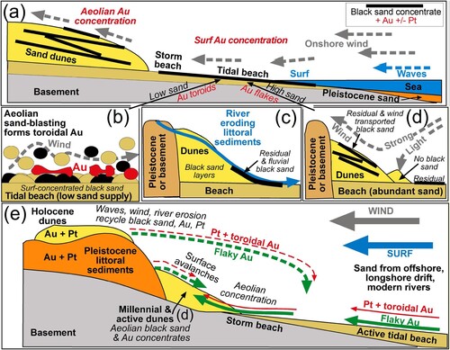
Figure 12. Schematic summary of aeolian processes affecting detrital gold on the Southland coast. (a) Generalised cross section of a beach to show the distinction between surf concentration and aeolian dune concentration. In low sand supply settings (e.g. Western Southland), aeolian sand-blasting forms gold toroids (as in b). (b) Aeolian toroidal gold formation in black sand residual concentrations on tidal beach (as in a). (c) Fluvial reconcentration of black sand by a coastal stream. (d) Aeolian black sand concentrations form in coastal dunes (as in a) during strong winds but not light winds. Abundant sand introduction and recycling from dunes limits toroid development and gold remains flaky. (e) Cross section through beach and dunes (as at Waipapa beach) where aeolian gold concentrations form in dunes and are recycled, with a mixing of flaky and toroidal gold (+ Pt) from contrasting long-distance transport pathways.
Aeolian concentration of gold
Dynamic coastal environments can form heavy mineral concentrates in a range of settings, from the surf zone to inland dune fields (Garnett and Bassett Citation2005; Hou et al. Citation2017; Dill and Buzatu Citation2022). Initial or additional concentration can result from fluvial activity where rivers meet the sea (Bluck et al. Citation2005; Hou et al. Citation2017; Dill and Buzatu Citation2022). All these processes are occurring at small scales along the southern coast of the South Island, and the most important processes in this study are wind-dominated (a–e). In particular, aeolian dune processes at Waipapa beach are the most important for the concentration of heavy minerals in that area (a,d), rather than surf concentration on the tidal beach that has occurred locally farther west (b; Craw and Kerr Citation2021; Craw, Kerr, Reith, et al. Citation2015). Aeolian concentrations of black sand at Waipapa beach pervade the dunes (e.g. a–d), in a similar manner to aeolian black sand concentrates elsewhere in the world (Force and Rich Citation1989; Dillenburg et al. Citation2004; Garnett and Bassett Citation2005; Hou et al. Citation2017; Dill and Buzatu Citation2022). However, the notable feature of the Waipapa beach dune black sand deposits, unlike most aeolian black sands elsewhere, is that they contain abundant detrital gold and minor detrital platinum (e.g. a,b).
The Millennial dunes, especially those at the Waipapa Stream mouth (), provide the best indications of the aeolian processes and time scales that lead to black sand concentrations (a–f). Sand is transported up-slope in the near-constant winds, and light winds only transport less dense minerals, mainly quartz, leaving residual black sand concentrates behind, with only minor mobilisation (a and d). When the winds are sufficiently strong, the black sand is physically mobilised with the predominant quartz, and is carried up-slope (d). However, there is also some sorting during this wind transport, so that dune bedding includes discrete black sand layers (a–d and d). Surficial black sand layers are periodically recycled short distances downslope in dry sand avalanches (b,c and e). In all these processes, the gold and platinum remain closely linked to the Fe–Ti oxide portions of the black sand layers (d) and either accumulate in the residues (light winds) or are entrained with these heavy minerals (strong winds).
Despite the on-going aeolian concentration and reconcentration of gold in the Waipapa beach dunes, most of the gold retains evidence of fluvial deformation but not incipient toroid formation (a–i and ). This observation is in stark contrast to aeolian beach gold processes in the Western Southland goldfield where toroids predominate as a result of sand-blasting on modern and Pleistocene beaches (a,b; Supp. Fig. S11; Craw and Kerr Citation2021; Craw, Kerr, Reith, et al. Citation2015; Palmer and Craw Citation2024a, Citation2024b, Citation2024c). These western beaches have relatively low sand supply, and largely lack dunes as sources of recycled sand, as the area is undergoing slow tectonic uplift creating coastal cliffs (Turnbull and Allibone Citation2003; Craw and Kerr Citation2021; Palmer et al. Citation2024). This setting with relatively low sand supply promotes abundant exposure to winds of heavy mineral concentrates at the surface of the tidal beaches for long periods (a; Craw and Kerr Citation2021; Craw, Kerr, Reith, et al. Citation2015; Palmer et al. Citation2024). In contrast, Waipapa beach apparently has a relatively abundant supply of sand from external sources and recycling of dunes, and black sand is rapidly incorporated into dune sand with only minimal surface exposure on open beaches where toroidal deformation could occur (b, and a,d,e). Similar sediment swamping of beach gold concentrates has been observed on the west coast of the South Island, with negligible sand-blasting effects on flaky fluvial gold morphology, despite abundant strong winds across the beaches (Palmer et al. Citation2024).
Authigenic mineral growth
Authigenic pyrite is widespread in Pleistocene littoral sediments at the Round Hill mining area (Craw and Kerr Citation2021; Palmer and Craw Citation2024b). The pyrite occurs as nodules, veins, cement, and mineral coatings at all scales from centimetres to microns, and was precipitated from local sulphate-bearing groundwater under low-redox conditions in a sedimentary sequence that contains abundant organic matter (Craw and Kerr Citation2021). Oxidation of this pyrite has occurred, and is occurring, wherever the sediments are exposed to the atmosphere or to higher redox groundwaters, yielding widespread ferric oxyhydroxide, jarosite and gypsum, and localised acidic waters (Craw and Kerr Citation2021; Palmer and Craw Citation2024c). The Pleistocene sediments at Waipapa beach are pervaded by secondary ferric oxyhydroxide stains, cement and veins (c,d,e), and this ferric oxyhydroxide is likely to be all or partially a result of oxidation of authigenic pyrite, similar to that exposed at Round Hill. The presence of fresh authigenic pyrite (i) and partially oxidised pyrite pseudomorphs (g) in younger dunes supports this conclusion. These observations suggest that sometime prior to the present erosional exposure of the Pleistocene sediments, they were pervaded by low-redox groundwaters (Supp. Fig. S8) similar to those that formed pyrite at Round Hill (Craw and Kerr Citation2021; Palmer and Craw Citation2024c).
Authigenic gold is widespread as overgrowths on detrital gold particles in southern New Zealand (Craw, Kerr, and Falconer, Citation2015; Craw, Kerr, Reith, et al. Citation2015; Craw and Kerr Citation2021; Palmer et al. Citation2024; Palmer and Craw Citation2024a, Citation2024b, Citation2024c). Hence, the presence of authigenic gold on several flakes from Waipapa beach (e and a,b; Supp. Fig. S8) is no surprise. However, since these authigenic overgrowths are so widespread regionally, it is not possible to define the specific timing or environment(s) in which they formed. The observed authigenic gold overgrowths are all in depressions or overhangs on the flakes (e and a,b), so they could have survived fluvial transport to the coast. It is likely that at least some of the overgrowths were added somewhere along their transport pathway, where similar gold is common, for example in the Pliocene goldfields of Southland adjacent to the Mataura River (a; Craw, Kerr, and Falconer, Citation2015).
Micron-scale authigenic gold overgrowths also occur on detrital silicate particles, and these irregular and delicate deposits are more exposed to deformation and/or potential removal by abrasion during transport (c–f). Hence, we infer that this authigenic gold has formed in the vicinity of Waipapa beach and has undergone minimal transport. Some of this authigenic gold is closely associated with clay (c), as is some of the authigenic gold overgrowths on gold flakes (a,b). Similar authigenic gold occurs associated with clay in Pleistocene sediments in the Round Hill goldfield (Palmer and Craw Citation2024a, Citation2024c). In addition, several pumpellyite clasts at Waipapa beach host micron-scale authigenic gold. This particular mineral relationship was not observed at Round Hill mine, but similar authigenic gold textures occur on a range of low-redox minerals, especially low-redox iron minerals, that were inferred to have facilitated precipitation of dissolved Au via reduction (Palmer and Craw Citation2024c).
The presence of what is interpreted to be an authigenic Ag-sulphide mineral (possibly acanthite; g,h; S9) implies some different groundwater chemical processes from those that operated at Round Hill (a) where authigenic native silver occurs in small quantities (Palmer and Craw Citation2024c). Geochemical modelling (Supp. Fig. S8) suggests that very low-redox conditions are needed to form acanthite rather than native silver in a sulphur-bearing solution. The apparent Ag-sulphate oxidation product coating the Ag-sulphide crystals (g,h) is not readily identifiable with present data, but may be Ag-bearing jarosite (Supp. Fig. S8, S9; Weisener et al. Citation2008; Craw and Kerr Citation2021).
Contrasting beach gold mining features
Mining of beach gold has occurred around the world, especially the Pacific rim, with most of these operations focusing on sands on tidal and storm beaches of various ages, where surf has been the principal driver of concentration of gold-bearing black sand deposits (Boyle Citation1979; Tan et al. Citation1994; Garnett Citation2000; Garnett and Bassett Citation2005; Kungurova Citation2021). Pleistocene-Holocene beach deposits on the west coast of the South Island of New Zealand (b) are typical examples of these sites with mineable surf-driven black sand (Williams Citation1974; Palmer et al. Citation2024). However, Pleistocene and Holocene surf beaches along the south coast of the South Island (this study) are different from the west coast in having only small accumulations of black sand concentrates and hence have only a minor mining history (Macpherson Citation1938; Williams Citation1974).
The Round Hill mining area, in the Western Southland goldfield (a; Supp. Fig. S11) has been focused on Pleistocene surf beach gold that was uplifted by regional tectonics and recycled by short Pleistocene streams into marginal marine channels (c; Macpherson Citation1938; Turnbull and Allibone Citation2003; Craw and Kerr Citation2021; Craw, Kerr, Reith, et al. Citation2015). In the Round Hill goldfield, aeolian concentration has been minor (Craw and Kerr Citation2021) but aeolian modification of gold morphology on surf beaches, prior to uplift and recycling, has produced the distinctive toroidal gold that persists along the coast to Waipapa Beach (d, (j–l) and (b); Supp. Fig. S11). The toroidal morphology survives the short fluvial recycling stages and those toroids that reach the coast may have been enhanced during further transport along the coast (a and b,c; Craw and Kerr Citation2021).
At Waipapa beach, similar fluvial recycling processes were important for past mining activity as well, although these processes are much younger as they are occurring on decadal, or even annual, time scales ((a) and (a–d)). All past mining operations at Waipapa beach have been located close to Waipapa Stream where fluvial processes have recycled gold-bearing black sand from Holocene dunes (cf. (c) and (a–d); PGM Citation1986; Papers Past Citation2024). These mining operations were forced to cease when this relatively rich ground was exhausted and the operations moved laterally into the Holocene dunes ((a–d); PGM Citation1986; Papers Past Citation2024). Without significant fluvial recycling, these dunes were apparently less economic to process. The historic operations were also hindered by the very fine particle size of the gold (Papers Past Citation2024), which we confirm herein ((f) and (a–i)). Our observations suggest that Waipapa Stream has concentrated some relatively coarse particles (up to 0.5 mm; e) that are rare in the dunes (where gold <200 µm greatly predominates), and this relatively coarse gold may have contributed to the efficiency of historic gold mining near to the stream.
Figure 13. Rejuvenation of the gold-bearing sands at the east end of Waipapa beach where historic gold dredges have processed fluvial and aeolean dune black sand concentrates. Distortions in historical photos cause some discrepancies in scales. (a) Aerial photo from 1948 (Retrolens.co.nz) shows the approximate location of the buried 1935–1937 dredge in the extensive fresh dune field (light grey area). Aeolian sand accumulation exceeded the erosional power of Waipapa Stream. (b) Aerial view (Google Earth) of the same area as a, in 2023, showing the extent of erosion of the 1948 sand accumulations. Blue dashed lines (also in a) show the present course of Waipapa Stream. (c) Aerial photo from 1967 (Retrolens.co.nz) showing persistence of aeolian sand accumulations, but Waipapa Stream had emerged and started to erode sand. (d) Aerial photo from 1985 (Retrolens.co.nz) of lower reaches of Waipapa Stream, showing re-development of the sand outwash delta. Dredge remnant has emerged from eroding dunes. The site of the establishment of Millennial dunes with abundant aeolian black sand and gold is indicated ( and a,c).
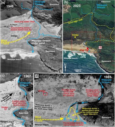
Waipapa stream as a gold repository
Despite substantial present-day coastal erosion at the western end of the beach, the beach face of the dune field farther east has had only minor changes since 1948 as it receives abundant wind-blown sand ( and a–d). However, the topography of the east end of Waipapa beach is such that prevailing winds drive sand onshore along the beach and into the extensive dune field at the eastern end. The eastern end forms a ‘corner’ in the Waipapa Stream catchment where a prominent basement ridge forms a backstop (Slope Point on the Catlins coast; a,c and a–d). Sand therefore accumulates periodically near the eastern end of the beach, especially in the middle reaches of Waipapa Stream (a). Waipapa Stream apparently flowed mainly under the sand in 1948 (a), but had mostly emerged by 1967 (c).
Much of the sand that had accumulated by 1948 in Waipapa Stream area has now been eroded by wind and Waipapa Stream ((a–d)), and presumably re-entered the beach or offshore environments (a and e). The Millennial dunes at the mouth of Waipapa Stream contain abundant aeolian black sand concentrates and gold that are being re-concentrated by Waipapa Stream ((a–f)). This combination of observable processes indicates that the Waipapa Stream area is an ideal trap and repository for black sand, and associated gold, some of which has been differentially retained (e.g. c, a and a–d) while the rest of the sand passed back into the coastal system. This provides further explanation for the east end of Waipapa beach being more attractive for gold mining (a,c,d,e) than either the western (up-wind) end, or the beaches farther along the Catlins coast that have only minor gold and platinum (Williams Citation1974; Craw and Kerr Citation2021).
A quantitative example of the significance of fluvial recycling is provided by the last dredge operation that started near to Waipapa Stream in 1935 ((a–d); Papers Past Citation2024). The dredge produced 188 ounces (oz) of gold (5.8 kg) in the first three weeks, but only another 30 oz (∼1 kg) in the following two weeks (Papers Past Citation2024). These results imply that yields dropped rapidly from an average of 63 oz/week to 15 oz/week as the most concentrated area near the stream was quickly exhausted. In the following financial year, the dredge produced 1055 oz (32.7 kg) of gold (Papers Past Citation2024), yielding an average over the year of only ∼20 oz/week. By the time the operation finished in 1937 because of waning returns, ∼2100 oz (∼67 kg) of gold had been produced (PGM Citation1986), also implying an overall average of ∼20 oz/week. Migration of the operation into the Holocene and active dunes was apparently sub-economic, although some of the reduction in production resulted from technical issues with the dredge (Papers Past Citation2024).
The dredge operation was hindered by the accumulation of blowing sand that produced dunes up to 3 m high during especially windy weather events (Papers Past Citation2024). Complete burial of the abandoned dredge site by active dunes over the following decade (a) confirms the significance of the blowing sand issue on limiting mining operations. However the gold-bearing black sand concentrates in this area have been rejuvenated over less than a century since mining ceased, as a result of the combination of aeolian and fluvial processes (, a–f and a–d). These rejuvenation processes are on-going, although stabilisation of dunes by vegetation may be limiting the effectiveness of these processes (a–d).
Conclusions
The Waipapa beach gold deposit is unusual, possibly unique, globally in having beach gold concentrated almost entirely in sand dunes by strong winds, with negligible surf-driven concentrations on the beach itself (d,e). The limited gold concentrates on the surf beach are temporary and largely derived from recycling of dunes during storms, and these concentrates are returned to the dunes by subsequent winds. The gold occurs in heavy mineral concentrates within quartz-rich sand, which are dominated by ilmenite and magnetite (black sand), accompanied by abundant green minerals apatite, pumpellyite and epidote. Black sand concentrates form layers on the mm to cm scale in the dunes and formed and reformed progressively during the Holocene. Accumulation and morphological modifications of dunes, with their contained black sand concentrates, occur on yearly and decadal time scales. The dunes are partly built on Pleistocene littoral deposits that also contain detrital beach gold, but only limited recycling of this Pleistocene gold is occurring in the modern environment. Fluvial recycling of Holocene dune sands has been important in upgrading the gold content, and historical mining focused on black sand accumulations near the largest stream, Waipapa Stream, that crosses the dune field ((c) and (a–d)).
Most of the gold (>90%) in the Waipapa beach dunes was derived from the Otago Schist via what is now the Mataura River system that passes through eastern Southland. This 200 km eastern pathway from Otago occurred in steps between Miocene and present, with multiple stages of recycling of gold and associated quartz-rich sediments during that time (a). A small proportion of the gold has aeolian toroidal morphology (b) and was derived, along with detrital platinum, from what is now the Waiau River system via eastward transport parallel to the present coast in the Pleistocene and/or Holocene. The original source of this gold was also Otago and this western transport pathway involved ∼300 km of travel, also involving multiple recycling stages since the Miocene (a). Platinum has not been reported from Eastern Southland gold deposits and is presumed to have accumulated, with the toroidal gold, on the Western Southland beaches before migrating along the coast to Waipapa beach.
The combination of these two sources of gold, the geomorphology of the Waipapa beach, and the prevailing strong westerly winds, has been important for the progressive accumulation of gold and black sand in the dune field. Sand has been blown along the beach oblique to the shoreline and periodically (decadal time scales) trapped in large volumes in a topographic cul de sac in Waipapa Stream against a backstop of a basement ridge ((a–d)). Erosion of this sand by the stream returned most of it to the coast, where it rejoined the longshore drift, leaving behind a residual component of black sand containing gold and platinum. The combination of aeolian and fluvial concentration was economically important for historic mining, and this combination of processes has been rejuvenating the gold-bearing concentrates over less than a century since mining ceased. The east-directed black sand supply is currently (since 1985) being enhanced by rapid (∼1 m/year horizontal) coastal erosion at the west end of the beach. Present vegetation on the dunes is stabilising the dune field that was previously largely unvegetated, and the processes of black sand accumulation may now be less efficient than during the Holocene and up to the 1990s. However, some dunes formed against the eroding cliff since 1985–1994, and these contain abundant layers of black sand with gold, attesting to the persistence and dominance of the aeolian concentration processes.
Acknowledgements
This project arose out of our research at the active Round Hill mine farther to the west, and the enthusiasm of Ray Stewart and Mark Skinner at that mine is much appreciated. Discussions and field visits with Donna Falconer and John Youngson in the goldfields of Southland were stimulating and helpful, although they may not agree with all our conclusions. SEM work was conducted at the Otago Micro and Nanoscale Imaging (OMNI) facility, University of Otago, New Zealand. Reviews by David Barrell and an anonymous referee substantially improved the presentation of the ms.
Disclosure statement
No potential conflict of interest was reported by the author(s).
Data availability statement
All data are included in this paper, cited references, and in a supplementary document available at figshare.com/articles/journal_contribution/Waipapa_Beach_gold_supplementary_document/26156152.
Additional information
Funding
References
- Ashley P, Craw D, MacKenzie D, Rombouts M, Reay A. 2012. Mafic and ultramafic rocks, and platinum mineralisation potential, in the Longwood Range, Southland, New Zealand. New Zealand Journal of Geology and Geophysics. 55:3–19. doi:10.1080/00288306.2011.623302.
- Bluck BJ, Ward JD, De Wit MCJ. 2005. Diamond mega-placers: Southern Africa and the Kaapvaal craton in a global context. Geological Society of London Special Paper. 248:213–245. doi:10.1144/GSL.SP.2005.248.01.12.
- Boyle RW. 1979. The geochemistry of gold and its deposits. Ottawa: Geological Survey of Canada. (Bulletin; 280. 579p).
- Chapman RJ, Banks DA, Styles MT, Walshaw RD, Piazolo S, Morgan DJ, Grimshaw MR, Spence-Jones CP, Matthews TJ, Borovinskaya O. 2021. Chemical and physical heterogeneity within native gold: implications for the design of gold particle studies. Mineralium Deposita. 56:1563–1588. doi:10.1007/s00126-020-01036-x.
- Chapman RJ, Craw D, Moles NR, Banks DA, Grimshaw MR. 2022. Evaluation of the contributions of gold derived from hypogene, supergene and surficial processes in the formation of placer gold deposits. Geological Society of London Special Publication. 516:291–311. doi:10.1144/SP516-2020-260.
- Chapman RJ, Moles NR, Bluemel B, Walshaw RD. 2022. Detrital gold as an indicator mineral. Geological Society of London Special Publication. 516:313–336. doi:10.1144/SP516-2021-47.
- Chapman RJ, Mortensen JK, LeBarge WP. 2011. Styles of lode gold mineralization contributing to the placers of the Indian River and Black Hills Creek, Yukon Territory, Canada as deduced from microchemical characterization of placer gold grains. Mineralium Deposita. 46:881–903. doi:10.1007/s00126-011-0356-5.
- Christie AB. 1979. Sedimentary structures in Quaternary iron sands at Waikato North Head, New Zealand. New Zealand Journal of Geology and Geophysics. 22:213–226. doi:10.1080/00288306.1979.10424220.
- Craw D, Campbell C, Waters JM. 2024. Miocene-Holocene river drainage evolution in Southland, New Zealand, deduced from fish genetics, detrital gold and geology. New Zealand Journal of Geology and Geophysics. 67:146–159. doi:10.1080/00288306.2022.2121289.
- Craw D, Kerr G. 2021. Physical and chemical evolution of a Pleistocene marginal marine gold paleoplacer deposit, southern New Zealand. Ore Geology Reviews. 138:104341. doi:10.1016/j.oregeorev.2021.104341.
- Craw D, Kerr G, Falconer D. 2015. Mineralogy and provenance of auriferous Waimumu Quartz Gravels, Southland, New Zealand. New Zealand Journal of Geology and Geophysics. 58:281–295. doi:10.1080/00288306.2015.1070182.
- Craw D, Kerr G, Reith F, Falconer D. 2015. Pleistocene paleodrainage and placer gold redistribution, western Southland, New Zealand. New Zealand Journal of Geology and Geophysics. 58:137–153. doi:10.1080/00288306.2015.1007462.
- Craw D, Mitchell M, McCann R, Reay A. 2013. Compositional variations and morphological evolution in platinum beach placers, southern New Zealand. Mineralium Deposita. 48:81–97. doi:10.1007/s00126-012-0417-4.
- Cullen DJ. 1967. The submarine geology of Foveaux Strait. New Zealand. New Zealand Oceanographic Institute, Memoir 33, Wellington, 67 pp.
- Dill HG, Buzatu A. 2022. From the aeolian landform to the aeolian mineral deposit in the present and its use as an ore guide in the past. Constraints from mineralogy, chemistry and sediment petrography. Ore Geology Reviews. 141:104490. doi:10.1016/j.oregeorev.2021.104490.
- Dillenburg SR, Tomazelli LJ, Barboza EG. 2004. Barrier evolution and placer formation at Bujuru, southern Brazil. Marine Geology. 203:43–56. doi:10.1016/S0025-3227(03)00330-X.
- Eyles N. 1990. Glacially derived, shallow-marine gold placers of the CapeYakataga district, Gulf of Alaska. Sedimentary Geology. 68:171–175. doi:10.1016/0037-0738(90)90110-F.
- Force ER, Rich FJ. 1989. Geologic evolution of Trail Ridge eolian heavy-mineral sand and underlying peat, northern Florida. US Geological Survey Professional Paper 1499, 16.
- Garnett RHT. 2000. Marine placer gold, with particular reference to Nome, Alaska. In: Cronan DS, editor. Handbook of Marine Mineral Deposits. Boca Raton, FL: CRC Press; pp. 67–101.
- Garnett RHT, Bassett NC. 2005. Placer deposits. Economic Geology 100th Anniversary volume, pp. 813–843.
- Hicks DM, Shankar U, McKerchar AI, Basher L, Jessen M, Lynn I, Page M. 2011. Suspended sediment yields from New Zealand rivers. Journal of Hydrology (New Zealand). 50:81–142.
- Hou B, Keeling J, Van Gosen B. 2017. Geological and exploration models of beach placer deposits, integrated from case-studies of southern Australia. Ore Geology Reviews. 80:437–459. doi:10.1016/j.oregeorev.2016.07.016.
- Knight JB, Morison SR, Mortensen JK. 1999. The relationship between placer gold particle shape, rimming and distance of fluvial transport; as exemplified by gold from the Klondike District, Yukon Territory, Canada. Economic Geology. 94:635–648. doi:10.2113/gsecongeo.94.5.635.
- Kungurova VE. 2021. Evaluating the effectiveness of fine gold extraction technologies on the example of titanomagnetite beach placers of the western coast of Kamchatka. Journal of the Mining Institute. 252:840–853. doi:10.31897/PMI.2021.6.6.
- Macpherson EO. 1938. Round Hill goldfield, Southland. New Zealand Journal of Science and Technology. 19:743–749.
- Mclachlan C, Negrini M, Craw D. 2018. Gold and associated minerals in the Waikaia placer gold mine, Northern Southland, New Zealand. New Zealand Journal of Geology and Geophysics. 61:164–179.
- Mitchell M. 1996. Alluvial platinum group minerals from southern New Zealand [unpublished PhD thesis], University of Otago, Dunedin, New Zealand. 277 pp.
- Nikiforova Z. 2021. Criteria for determining the genesis of placers and their different sources based on the morphological features of placer gold. Minerals. 11:381–404. doi:10.3390/min11040381.
- NIWA. 2024. National Institute and Water and Atmospheric Research websites: https://www.niwa.co.nz/climate; https://www.cliflo.niwa.co.nz.
- Palmer M, Craw D. 2024a. Morphology and structural evolution of fine beach gold in comparison to detrital platinum, southern New Zealand. Mineralium Deposita. 59:69–83. doi:10.1007/s00126-023-01200-z.
- Palmer M, Craw D. 2024b. Detrital gold morphology and recycling around the early Miocene St Bathans paleovalley, Central Otago, New Zealand. New Zealand Journal of Geology and Geophysics (on-line 2023). doi:10.1080/00288306.2023.2284281.
- Palmer M, Craw D. 2024c. Fine and super-fine gold in mine waste from a coastal placer in southern New Zealand. New Zealand Journal of Geology and Geophysics (on-line 2024). doi:10.1080/00288306.2024.2331475.
- Palmer M, Ritchie T, Craw D. 2024. Contrasting evolution of beach gold on two sides of an active orogen, Southern Alps, New Zealand. New Zealand Journal of Geology and Geophysics (on-line February 2024). doi:10.1080/00288306.2024.2314468.
- Papers Past. 2024. Waipapa Beach gold dredging; www.paperspast.natlib.govt.nz. Otago Daily Times, 4 March 1889, Issue 8432, p. 3; 11 September 1935, Issue 22673, p. 5; 11 December 1935, Issue 22751, p. 14; 17 March 1938, Issue 23452, p. 6. Evening Star, 18 November 1936, Issue 22499, p. 8.
- PGM. 1986. Platinum Group Metals (No Liability). Company prospectus for share issue, 60 pp.
- Stein J, Craw D, Pope J. 2011. Initial sedimentation and subsequent diagenesis in the Eastern Southland Lignite Basin, southern New Zealand. New Zealand Journal of Geology and Geophysics. 54:167–180. doi:10.1080/00288306.2010.515599.
- Tan LP, Chen CH, Yeh TK, Takeuchi A. 1994. Tectonic and geochemical characteristics of Pleistocene gold deposits in Taiwan. In: Jones M, Cosgrove J, editors. Neotectonics and resources. London: Bellhaven Press; pp. 290–305. ISBN 978-0471945130.
- Townley BK, Herail G, Maksaev V, Palacios C, De Parseval P, Sepulveda F, Orellana R, Rivas P, Ulloa C. 2003. Gold grain morphology and composition as an exploration tool: application to gold exploration in covered areas. Geochemistry: Exploration, Environment, Analysis. 3:29–38. doi:10.1144/1467-787302-042.
- Turnbull IM, Allibone AH. 2003. Geology of the Murihiku area. Lower Hutt, New Zealand: Institute of Geological and Nuclear Sciences 1:250 000 Geological map 20.
- Upton P, Craw D. 2016. Coeval emplacement and orogen-parallel transport of gold in oblique convergent orogens. Tectonophysics. 693(Part B):197–209. doi:10.1016/j.tecto.2016.01.015.
- Weisener CG, Babachuk MG, Fryer BJ, Maunder C. 2008. Microbial dissolution of silver jarosite: Examining its trace metal behaviour in reduced environments. Geomicrobiology Journal. 25:415–424. doi:10.1080/01490450802403073.
- Williams GJ. 1974. Economic Geology of New Zealand. Australasian Institute of Mining and Metallurgy. (Monograph; 4. 490p).
- Wood J, Meyers J, Vidanovich P. 2016. Aotea ironsand deposit, Waikato region, North Island. In: A.B. Christie, editor. Mineral deposits of New Zealand: exploration and research. Australian Institute of Mining and Metallurgy Monograph 31; pp. 427–434.
- Youngson JH. 2005. Diagenetic silcrete and formation of silcrete ventifacts and aeolian gold placers in central Otago, New Zealand. New Zealand Journal of Geology and Geophysics. 48:247–263. doi:10.1080/00288306.2005.9515113.
- Youngson JH, Craw D. 1999. Variation in placer style, gold morphology, and gold particle behavior down gravel bed-load rivers: an example from the Shotover/Arrow-Kawarau-Clutha river system, Otago, New Zealand. Economic Geology. 94:615–634. doi:10.2113/gsecongeo.94.5.615.