Abstract
AIMS: To determine the proportion of residential land parcels with backyard poultry in an urban and urban-rural fringe area of provincial New Zealand. To document key husbandry and biosecurity practices of owners of backyard poultry, and to identify factors that might assist animal health authorities in locating backyard poultry flocks in the event of an infectious disease emergency.
METHODS: A cross-sectional survey was undertaken, in which residents of 449 land parcels in an urban and urban-rural fringe area within and adjacent to the city of Palmerston North, respectively, were visited between February and November 2006. Residents were asked if backyard poultry were kept on the premises. Details recorded for those that kept poultry included the type and number of birds kept, and details of management and biosecurity practices. The geographical distribution of poultry-positive land parcels was assessed for evidence of spatial clustering.
RESULTS: Backyard poultry were kept on 3.5 (95% CI=2.15.0)% of land parcels; 1.6 (95% CI=0.7-3.4)% in the urban area and 18.9 (95% CI= 11.6–29.3)% in the urban-rural fringe area. There were no significant clusters of poultry-positive land parcels in either area. On all poultry-positive parcels birds were allowed, for at least a portion of the day, to range freely over the property. Three poultry-positive land parcels were within a distance of 1 km of a commercial poultry enterprise in the urban-rural fringe area. Most owners of backyard poultry used feed prepared commercially.
CONCLUSIONS: The prevalence of ownership of backyard poultry in this area of New Zealand was low, and varied according to classification of the land, viz urban, or urban-rural fringe. The close proximity of backyard flocks to the single commercial enterprise in the urban-rural fringe area reiterates the importance of strict biosecurity measures on commercial farms. In the event of an infectious disease emergency, it is proposed that a sampling frame of owners of backyard poultry might be rapidly obtained by contacting suppliers of commercial feed.
| HPAI | = |
Highly pathogenic avian influenza |
| IBD | = |
Infectious bursal disease |
| ND | = |
Newcastle disease |
Introduction
In New Zealand, as in other developed countries, there is a sizeable commercial poultry industry, in which the flocks are well characterised in terms of numbers, location, and management practices. The same cannot be said however for non-commercial (‘backyard’) poultry flocks, where relatively little is documented about their size and composition, their geographical distribution, and how they are managed. New Zealand's commercial poultry industry has a unique high health status; highly pathogenic avian influenza (HPAI) and Newcastle disease (ND) have never been diagnosed, and a programme to eradicate infectious bursal disease (IBD) is nearing completion (Brooks Citation2003; Gerber Citation2008).
Lack of knowledge about the non-commercial sector of the domestic poultry population is of concern to both the commercial poultry industry and animal health authorities, firstly because there is an increased likelihood of introduction of infectious disease into backyard flocks due to inevitably varying levels of biosecurity, and secondly, in the event of an infectious disease outbreak, backyard flocks may pose a risk to commercial poultry enterprises if links between the two types of enterprise exist. Knowledge of the key characteristics of the backyard poultry sector in terms of size and composition, geographical distribution, and management practices is important given international concern about the spread of HPAI (Jutzi Citation2005). Better understanding of these factors help to assess and mitigate the risks backyard poultry flocks pose to the commercial poultry industry.
The objective of this study was to describe the backyard poultry sector in a provincial area of New Zealand. A survey was conducted to determine the proportion of residential land parcels where backyard poultry were kept, details of the number and type of birds kept, and key husbandry and biosecurity practices. A secondary objective of the study was to identify factors that might assist animal health authorities in locating backyard poultry flocks in the event of an infectious disease emergency.
Materials and methods
Study design
A cross-sectional study was conducted to determine the proportion of residential land parcels in and adjacent to the city of Palmerston North, in the North Island of New Zealand, that kept backyard poultry. For the purpose of this study, the term ‘backyard poultry’ is used to refer to chickens, ducks, geese (anserines), guinea fowl (Numididae), peafowl (Pavo spp.), ostriches (Struthio camelus), pheasants (phasianines), pigeons (Columbidae), swans (Cygnus spp.), or turkeys (Meleagris spp.) housed in sheds or pens external to the main human-living area. The urban area was 20.1 km2 in size, located within the city limits of Palmerston North (longitude 175°, latitude -40°), and the urban-rural fringe area was 16.4 km2 in size, located adjacent to the Palmerston North city limits and within a 10–15-minute drive from the central business district of the city (Figure ).
A questionnaire was developed to provide a description of the type and number of birds kept, and details of management and biosecurity practices present on each poultry-positive land parcel (see Supplementary Table Footnote 1 ). Within the questionnaire, emphasis was placed on recording direct and indirect contacts between wild birds and backyard poultry, and the specific nature of management activities, e.g. movements of poultry and poultry product, types and sources of feed, and details of biosecurity practices.
The sampling frame for the urban area was comprised of details for 5,566 land parcels obtained from the Land Information New Zealand core record system (Anonymous Citation2007). The sampling frame for the urban-rural fringe area was comprised of details for 172 land parcels obtained from AgriBase, the national index of ownership and location of agricultural property in New Zealand (Sanson and Pearson Citation1997). Land parcels were categorised into terciles, and classified as either small (10–650 m2), medium (650–780 m2), or large (>780 m2). To determine an appropriate number of land parcels to sample, it was assumed that 50% of land parcels within each study area and area stratum had backyard poultry. Estimates of sample size based on an expected prevalence of 50% ownership of backyard poultry provided the largest sample size required for a 95% level of confidence and constant margin of error. To meet the pre-specified requirements of the survey, a total of 449 land parcels (375 urban and 74 urban-rural fringe) were selected from the Land Information New Zealand and AgriBase data frames. Land parcels to be surveyed were selected from each sampling frame at random, for each size stratum.
To ensure that residents of land parcels would be at home when they were visited for questioning, the questionnaire was administered over a series of Saturday and Sunday afternoons between February and November 2006 by the same two people. Each of the selected land parcels was visited, and residents asked if backyard poultry were kept on the property. Where poultry were present, the questionnaire was administered. In the event that the resident of the selected parcel was not at home at the time of the visit, a land parcel immediately adjacent was selected. Land parcels found to be commercial properties, schools, or non-residential were subsequently removed from the sampling frame, and the appropriate number of land parcels re-sampled and visited at a later date.
Statistical analysis
Responses to the questionnaire were entered into a relational database, and exported to the statistical package R v2.9.1 (R Development Core Team, 2009; R Foundation for Statistical Computing, Vienna, Austria) for analysis. To compare responses from the urban and rural areas Fisher's exact test was used for count data, and the Wilcoxon rank-sum test for continuous variables. Results obtained for each study area were compared for each of the factors investigated. Significance was based on α=0.05.
Figure 1. Maps showing (a) the boundaries of Palmerston North city (x = central business district) and the location of two study areas (A = urban area; B = urban-rural fringe area) relative to the city boundaries, and locations of the poultry-positive (![]() ) and -negative (
) and -negative (![]() ) land parcels in mesh-blocks comprising (b) the urban area, and (c) urban-rural fringe area.
) land parcels in mesh-blocks comprising (b) the urban area, and (c) urban-rural fringe area.
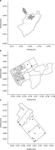
Table 1. Details of the total number of land parcels, the number of land parcels surveyed, and the number of surveyed land parcels with backyard poultry in urban and urban-rural fringe areas within and adjacent to the city of Palmerston North.
Table 2. Details of the number of birds kept, and management of backyard poultry in urban and urban-rural fringe areas within and adjacent to the city of Palmerston North.
To assess whether poultry-positive land parcels were spatially aggregated, the spatial scan statistic was used (Kulldorff and Nagarwalla Citation1995; Kulldorff Citation1997). The spatial scan statistic can be applied as a non-focussed test for spatial clustering, and operates by imposing a series of circular windows around each of a series of possible cluster centroids (in this case poultry-positive land parcels) positioned throughout each study area. For each centroid the radius of the window varies continuously in size from zero to 50% of the total population at risk, creating a number of distinct geographical circles, with each being a possible candidate for a cluster. For each location and size of the scanning window the alternative hypothesis is that there is an elevated number of poultry-positive land parcels within the window, compared with outside. Once the window with the greatest likelihood ratio statistic was identified, its sampling distribution was evaluated using a Monte Carlo test. Used in this way, the spatial scan statistic is able to identify the location of the most likely geographical cluster (in terms of its centroid and radius), and the probability that this cluster has arisen by chance.
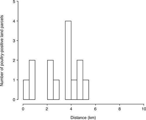
There was a single commercial poultry enterprise, as listed within AgriBase, in the urban-rural fringe area. The Euclidean distance from the farm gate of this enterprise to the centroids of each of the 14 poultry-positive land parcels within the urban-rural fringe area was computed, and plotted as a frequency histogram. The farm gate was used as the location marker for the commercial enterprise, as recorded in AgriBase.
Results
Details of the number of land parcels sampled and their backyard poultry status, stratified by size and study area, are provided in Table . Descriptive statistics for each of the variables recorded in the questionnaire, stratified by study area, are provided in Table .
The prevalence of land parcels with backyard poultry in both study areas, calculated using a technique that respected the stratified design of the study (Levy and Lemeshow Citation1999) was 3.5 (95% CI=2.1–5.0)%. In the urban area, the prevalence of land parcels with backyard poultry was 1.6 (95% CI=0.7–3.4)%; in the urban-rural fringe area, it was 18.9 (95% CI= 11.6–29.3)%. The median number of birds per parcel was similar for both the urban and urban-rural fringe areas (Table ). Poultry were mainly kept as pets in the urban area (4/6 responses), whereas in the urban-rural fringe area they were predominantly kept as a source of food (8/14 responses).
All residents of poultry-positive parcels allowed their birds to range freely within the boundaries of the property during the day, with seven respondents allowing continual access outside. In the urban-rural fringe area, 11/14 respondents provided a shed or coup, while three allowed birds to continuously free-range. In the urban area, 2/6 respondents kept birds in sheds, while four allowed birds to continuously free-range.
Methods for disposal of carcasses did not differ in the two study areas (Fisher's exact test p=0.48); for both areas burial was the method most frequently cited for disposal of carcasses. The majority of respondents in both study areas used purchased feeds as the primary source of feed; the remainder used a mixture of purchased feeds and kitchen scraps (Table ).
The two areas did not differ in terms of movement of poultry or poultry product onto (Fisher's exact test p=1.00) or off (Fisher's exact test p=0.27) premises. A total of 8/20 poultry-positive land parcel residents reported movement of poultry or poultry product either on or off their premises in the last 12 months. These were related to the movement of eggs and adult birds gifted or sold to friends.
There were no significant clusters of poultry-positive land parcels in either study area (log likelihood ratio statistic 6.74; p=0.17, and log likelihood ratio statistic 3.45; p=0.89 for the urban and urban-rural fringe area, respectively). The 14 poultry-positive land parcels in the urban-rural fringe area were located within a 6-km radius of a single commercial poultry enterprise with a capacity for 30,000 adult birds in the same area. Three of the 14 poultry-positive land parcels were within a distance of 1 km of the commercial enterprise (Figure ); the closest poultry-positive land parcel was 330 m from the commercial enterprise.
Discussion
The results from the study presented here showed that backyard poultry were kept by a small proportion of residents on residential land parcels (3.5 (95% CI=2.1–5.0)% and, if birds were kept, the size of flocks was small (median six, range 1–33). The prevalence of ownership of backyard poultry was significantly greater in the urban-rural fringe area compared with the urban area, although the number of birds kept per land parcel was similar between the two study areas. The difference in the prevalence of ownership of backyard poultry among the two areas may relate to council bylaws limiting the numbers of birds that may be kept in built-up areas of the city or due to the greater tendency for residents on ‘lifestyle’ blocks in the urban-rural fringe area to keep a range of domestic animals apart from dogs and cats. Although the prevalence of ownership of poultry in the urban-rural fringe was greater than that in the urban area, the density of birds per square kilometre in both areas was low.
Studies overseas have identified the backyard poultry sector as often the first to be affected in the event of incursions of infectious diseases such as HPAI and ND (Crespo et al. Citation1999; Capua et al. Citation2002). Because of links through common suppliers and activities, backyard poultry flocks may pose a risk to commercial poultry, especially when biosecurity measures on commercial poultry farms are poor (Rawdon et al. Citation2007, Citation2008). Infectious diseases of poultry such as HPAI and ND with short incubation periods (Mishra et al. Citation2001) and a tendency towards a rapid clinical course, require high densities of birds for spread (Mannelli et al. Citation2007; Thrusfield Citation2007). The findings from the study presented here indicated that if backyard poultry in these areas were to become infected with either of these pathogens, spread of disease would be unlikely to arise from localised, backyard flock-to-flock transmission (‘local spread’). Spread of disease, if it were to occur, would be more likely via the movement of infected material onto other enterprises via contaminated vehicles, clothing and shoes, and/or wild birds (Halvorson et al. Citation1980; Webster et al. Citation1992; Akey Citation2003; McQuiston et al. Citation2005; Boon et al. Citation2007).
Figure 2. Frequency histogram for poultry-positive land parcels within specified distances of a commercial poultry enterprise within an urbanrural fringe area adjacent to the city of Palmerston North.
In contrast to HPAI and ND, IBD virus is more stable in the environment, and has a longer clinical course with extended shedding. Based on the findings reported in this study, we believe an incursion of IBD into backyard flocks could present some risk of local spread of disease into commercial poultry flocks given backyard poultry flocks can be present within short distances of commercial farms. These risks should be considered when animal health authorities provide advice to owners of backyard flocks regarding biosecurity, and when regulatory bodies consider cut-offs for sizes of flocks for mandatory registration schemes for poultry (Houston et al. Citation2006).
No evidence of formal or informal links between residents on land parcels where backyard poultry were kept and the commercial poultry sector on the basis of movements of poultry or poultry product from poultry-positive land parcels to commercial premises, and vice versa, was found. This probably reflects the condition of employment practised by most of the major commercial poultry companies, which requires workers not to keep domestic poultry on their home premises. Movements of poultry and/or poultry product between informal and commercial poultry sectors have, in other countries, been associated with widespread dissemination of disease (Panigrahy et al. Citation2002; Garber et al. Citation2007).
In the study presented here, the prevalence of a range of practices that might increase the risk of exposure of backyard poultry to infectious disease was enumerated. Free-ranging of birds was permitted for periods of up to 24 hours in all poultry-positive land parcels, a practice likely to increase the probability of contact with wild birds. A number of studies have implicated wild birds as a source of exposure for incursions of avian influenza into both commercial and non-commercial poultry farms (Kaoud Citation2007; Saad et al. Citation2007). As part of epidemic contingency planning, effort should be applied to educate owners of backyard poultry regarding the risks that wild birds might pose in terms of disease transmission (Muller et al. Citation1999).
The predominant method of disposal of carcasses on the premises surveyed was by burial, in both study areas. This would imply that the risk of spread of disease via infected carcasses would be unlikely in the event of an infectious disease outbreak. Similar findings were reported by McBride et al. (Citation1991) in a study of backyard poultry flocks in California, in the United States of America. Purchased feed was the feed of choice for poultry in both study areas, although the use of kitchen scraps as a source of feed was common. Determining the content of kitchen scraps was not an objective of this study, but its use may result in a potential pathway for introduction of disease into backyard flocks if contaminated meat is fed; diseases such as HPAI, ND and IBD could potentially be introduced in this way. A recent study conducted to determine the ability of chicken meat to transmit avian influenza found that feeding breast or thigh meat from HPAI H5N1-infected chickens to other chickens resulted in infection and death (Swayne and Beck Citation2005). On the basis of commercially prepared feed being used commonly among owners of backyard poultry flocks we propose that, in the event of an infectious disease emergency, a sampling frame of owners of backyard poultry might be rapidly obtained by contacting commercial feed suppliers (Freier et al. Citation2004). This is important, as most of the flock owners surveyed did not belong to a poultry club or association.
A useful area of future research would be to replicate this study design in a number of regional centres throughout New Zealand. This would allow a more comprehensive picture of ownership of backyard poultry throughout the country to be developed, and would eliminate the need to attempt a census of populations of backyard poultry. In addition, such a methodology would be suitable for enumerating other species of interest, such as backyard pigs, to animal health authorities. Our experience from this particular study was that it was easy to administer the questionnaire to relatively large numbers of residents over a short period of time, given the opening question to respondents was simply “Do you keep poultry?” and, in the majority of cases, when the answer to this question was no, the interview was terminated, allowing us to move onto the next premises selected for sampling. Collection of occupancy details at the time of interview (e.g. ethnicity details, whether or not the premises were rented) and using this information in conjunction with human census data would allow predictive models of the distribution of backyard flocks to be developed, which in turn would allow the distribution of these hard-to-quantify populations to be estimated with greater certainty. This information would be invaluable to animal health authorities for developing surveillance strategies, responding to disease incursions, and when developing post-response freedom plans.
65654supplementaryinformation.pdf
Download PDF (207.4 KB)Acknowledgement
This study was funded by the Pacific Vet Avian Health Research Fund, Christchurch, New Zealand.
Notes
References
- Akey , BL . 2003 . Low-pathogenicity H7N2 avian influenza outbreak in Virginia during 2002 . Avian Diseases , 47 ( Supplement ) : 1099 – 103 .
- Anonymous Land Information New Zealand Wellington, , NZ 2007 www.linz.govt.nz/ (accessed 15 April 2010)
- Boon , AC , Sandbulte , MR , Seiler , P , Webby , RJ , Songserm , T , Guan , Y and Webster , RG . 2007 . Role of terrestrial wild birds in ecology of influenza A virus (H5N1) . Emerging Infectious Diseases , 13 : 1720 – 1724 .
- Brooks , M . 2003 . Poultry disease surveillance in New Zealand . Surveillance , 30 ( 1 ) : 13 – 14 .
- Capua , I , Dalla , Pozza M , Mutinelli , F , Marangon , S and Terregino , C . 2002 . Newcastle disease outbreaks in Italy during 2000 . Veterinary Record , 150 : 565 – 568 .
- Crespo , R , Shivaprasad , HL , Woolcock , PR , Chin , RP , Davidson-York , D and Tarbell , R . 1999 . Exotic Newcastle disease in a game chicken flock . Avian Diseases , 43 : 349 – 355 .
- Freier , J , Millar , R , Maroney , S and FitzMaurice , P . 2004 . Spatially-targeted surveillance for Newcastle disease in southern California . Proceedings of GISVET 2004 , : 13 – 13 .
- Garber , L , Hill , G , Rodriguez , J , Gregory , G and Voelker , L . 2007 . Non-commercial poultry industries: Surveys of back-yard and gamefowl breeder flocks in the United States . Preventive Veterinary Medicine , 80 : 120 – 128 .
- Gerber , N . 2008 . Infectious bursal disease eradication programme . Surveillance , 35 ( 2 ) : 30 – 30 .
- Halvorson , DA , Karunakaran , D and Newman , JA . 1980 . Avian influenza in caged laying chickens . Avian Diseases , 24 : 288 – 294 .
- Houston , CW , Gibbens , JC , Jordan , L , Wilesmith , JW , Smith , LH , Roberts , S , Paiba , GA , Parish , WEG and Lyons , RE . 2006 . Experiences in the capture of poultry population data for an emergency response . Proceedings of the 11th International Symposium on Veterinary Epidemiology and Economics , T3-1.2.3
- Jutzi , S . 2005 . Stop the disease at its source. FAO, OMS, OIE, and WorldBank Conference on Avian Influenza and Human Pandemic Influenza , Geneva, , Switzerland : Food and Agriculture Organization of the United Nations . http://www.fao.org/avianflu/documents/geneva-speech.pdf (accessed 19 March 2010)
- Kaoud , H . 2007 . HPAI epidemic in Egypt: evaluation, risk factors and dynamic of spreading . International Journal of Poultry Science , 6 : 983 – 988 .
- Kulldorff , M . 1997 . A spatial scan statistic . Communications in Statistics: Theory and Methods , 26 : 1481 – 1496 .
- Kulldorff , M and Nagarwalla , N . 1995 . Spatial disease clusters: Detection and inference . Statistics in Medicine , 14 : 799 – 810 .
- Levy , PS and Lemeshow , S . 1999 . “ Stratification and stratified random sampling ” . In Sampling of Populations; Methods and Applications , 3rd Edtn , 121 – 143 . New York, , USA : Wiley .
- Mannelli , A , Busani , L , Toson , M , Bertolini , S and Marangon , S . 2007 . Transmission parameters of highly pathogenic avian influenza (H7N1) among industrial poultry farms in northern Italy in 1999–2000 . Preventive Veterinary Medicine , 81 : 318 – 322 .
- McBride , MD , Hird , DW , Carpenter , TE , Snipes , KP , Danayeelmi , C and Utterback , WW . 1991 . Health survey of backyard poultry and other avian species located within one mile of commercial California meat-turkey flocks . Avian Diseases , 35 : 403 – 407 .
- McQuiston , JH , Garber , LP , Porter-Spalding , BA , Hahn , JW , Pierson , FW , Wainwright , SH , Senne , DA , Brignole , TJ , Akey , BL and Holt , TJ . 2005 . Evaluation of risk factors for the spread of low pathogenicity H7N2 avian influenza virus among commercial poultry farms . Journal of the American Veterinary Medical Association , 226 : 767 – 772 .
- Mishra , S , Kataria , JM , Sah , RL , Verma , KC and Mishra , JP . 2001 . Studies on the pathogenicity of Newcastle disease virus isolates in guinea fowl . Tropical Animal Health and Production , 33 : 313 – 320 .
- Muller , T , Hlinak , A , Mühle , RU , Kramer , M , Liebherr , H , Ziedler , K and Pfeiffer , DU . 1999 . A descriptive analysis of the potential association between migration patterns of bean and white-fronted geese and the occurrence of Newcastle disease outbreaks in domestic birds . Avian Diseases , 43 : 315 – 319 .
- Panigrahy , B , Senne , DA and Pedersen , JC . 2002 . Avian influenza virus subtypes inside and outside the live bird markets, 1993–2000: A spatial and temporal relationship . Avian Diseases , 46 : 298 – 307 .
- Rawdon , T , Thornton , R , McKenzie , J and Gerber , N . 2007 . Biosecurity risk pathways in New Zealand's commercial poultry industry . Surveillance , 34 ( 3 ) : 4 – 9 .
- Rawdon , T , Tana , T , Frazer , J , Thornton , R and Chrystal , N . 2008 . Biosecurity risk pathways in the commercial poultry industry: free-range layers, pullet-rearers and turkey broilers . Surveillance , 35 ( 4 ) : 4 – 9 .
- Saad , MD , Ahmed , LS , Gamal-Eldein , MA , Fouda , MK , Khalil , FM , Yingst , SL , Parker , MA and Montevillel , MR . 2007 . Possible avian influenza (H5N1) from migratory bird Egypt . Emerging Infectious Diseases , 13 : 1120 – 1121 .
- Sanson , RL and Pearson , AP . 1997 . AgriBase - a national spatial farm database . Proceedings of the 8th International Symposium on Veterinary Epidemiology and Economics , : 12.16.11 – 12.16.13 .
- Swayne , DE and Beck , JR . 2005 . Experimental study to determine if low-pathogenicity and high-pathogenicity avian influenza viruses can be present in chicken breast and thigh meat following intranasal virus inoculation . Avian Diseases , 49 : 81 – 85 .
- Thrusfield , M . 2007 . “ The transmission and maintenance of infection ” . In Veterinary Bpidemiology , 3rd Edtn , 98 – 115 . London, , UK : Blackwell Science .
- Webster , RG , Bean , WJ , Gorman , OT , Chambers , TM and Kawaoka , Y . 1992 . Evolution and ecology of influenza-a viruses . Microbiological Reviews , 56 : 152 – 179 .
- http://www.sciquest.org.nz/node/65654