
Abstract
SUMMARY: In the decades of the 1620s and 1630s the Dutch engaged in salt extraction on the island of La Tortuga, Venezuela, erecting a wooden fort, portable cannon emplacements, jetties and semi-industrial solar saltpan production facilities. The relative paucity of the archaeological record juxtaposed with the wealth of detailed documentary data and fieldwork experiences led to the operationalization of the heuristic tool of ‘scapes’. A critical construction of these socially alive portions of the island landscape and seascape demonstrates 1) how north-western European conceptions of the cultural control of nature were embodied in Dutch orderliness and industriousness; 2) how the strategy of maximization of extractive practices and minimization of risk was evidenced in the overall ephemerality of structures; and 3) how these structural imperatives were imbricated in the prose of human life and death that was unfolding from one small-scale event to another on this desolate island.
INTRODUCTION
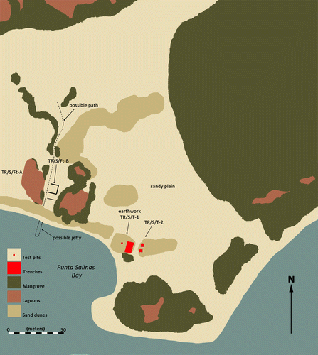
La Tortuga is the second-largest Venezuelan island (c. 24km by 10km) and is located some 87km off the north-eastern coast of the country (). This flat calcareous platform is covered by xeric, shrubby vegetation and has no permanent freshwater sources, native mammals, rodents or ophidians. It has never been occupied permanently. Archaeological survey carried out on La Tortuga in 1992 revealed the presence of one colonial and several pre-colonial sites.Footnote1 This paper focuses on the colonial site situated in the vicinity of the natural saltpans, a series of shallow landlocked lagoons spanning from south-west to north-east on the island’s south-eastern point (). The saltpans are separated from the seashore by a sandy plain where the majority of colonial features and artefacts were recovered. The seashore beyond the plain takes the form of a ridge of small dunes fronting storm terraces descending to the sea; beyond lies a bay providing anchorage. Hereafter, we refer to the lagoons, the sandy plain, the seashore and the bay as the Punta Salinas site ().
Systematic excavations were carried out at Punta Salinas in 1993, 2009 and 2010. They included the excavation of over 60 shovel pits (500 × 500mm), 41 test pits (1000 × 1000mm) and 11 trenches, the locations of which were determined by the results of shovel test pit excavations (higher frequency and diversity of archaeological materials and features). All excavation units were dug stratigraphically in layers of 100mm each; selected units, including all the trenches, were dry-sieved through a 1mm mesh. As a result of the surveys and excavations, a palimpsest of three phases of human activity emerges at the Punta Salinas site: 1) pre-colonial and early-colonial Amerindian, AD 900–1638; 2) Dutch, Spanish and Amerindian, 1624–38; and 3) Anglo-American, 1638–1781.Footnote2 Our aim in this paper is to analyse and confront the archaeological and documentary sources to shed light on the nature and dynamics of the second phase.
FIG. 1 La Tortuga Island within the wider geographical context of the Caribbean.
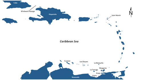
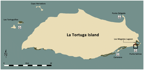
FIG. 2 Map of La Tortuga Island and its main anchorages.
The following section reviews events preceding the Dutch appearance on La Tortuga, events that figure prominently in the global expansion of the Dutch mercantile capitalism which was to usher in the Dutch Golden Age. In the succeeding sections, we operationalize the concepts of three La Tortuga ‘-scapes’ and use these to discuss the correlates between the archaeological record and the micro-scale events described by the documentary sources. Finally, we offer our conclusions and propose a few avenues for future research.
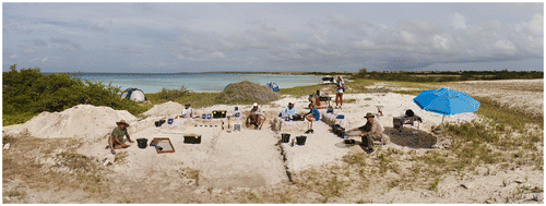
FIG. 3 Aerial view of the Punta Salinas site (photograph, José Miguel Pérez Gómez).
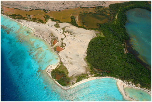
FIG. 4 Map of the saltpans and Los Mogotes Lagoon surrounding the site of Punta Salinas.
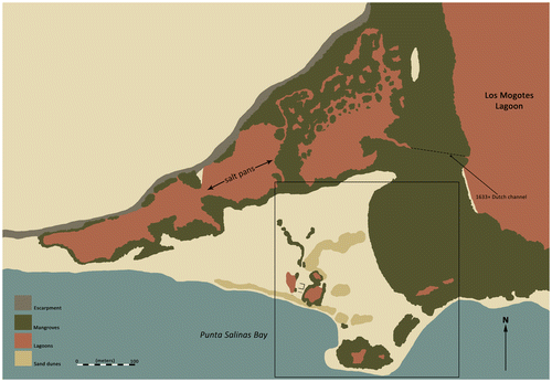
FIG. 5 Map of the site of Punta Salinas.
THE QUEST FOR SALT IN THE VENEZUELAN CARIBBEAN
On the first of June 1595, two Dutch merchant ships entered the bay of Cumaná, the modest capital of the Spanish overseas Province of Nueva Andalucía (today northeast Venezuela).Footnote3 Spanish trading vessels rarely appeared in this corner of the New World,Footnote4 so Dutch merchants eagerly strove to meet local demand for European goods. They formed part of the first wave of Dutch traders dealing directly with the Venezuelan Caribbean.Footnote5
Three years later, in an attempt to destroy the lucrative maritime trade constituting the economic backbone of the rebellious Dutch Republic, the Spanish Crown banned Dutch ships and goods from all Iberian ports.Footnote6 This measure dramatically affected the traditional Dutch supply of salt from the saline estuaries adjacent to the ports of Setubál and Aveiro in Portugal.Footnote7 Salt and salt-cured herring were fundamental products of the Dutch Mother Trade, the highly lucrative ongoing commerce with the Baltic countries.Footnote8 In response to these prohibitive measures, Dutch trade in the Caribbean, especially in Venezuela, was restructured from the ‘rich’ to the ‘bulk’ type and focused on salt.Footnote9
In 1599, merchants from West Friesian towns (chiefly Hoorn, Enkhuizen and Medemblik)Footnote10 sent the first salt-specialized fleet — lightly armed and unescorted by warships and soldiers — to the large saltpan at Punta Araya, located 13km north-west of Cumaná ().Footnote11 Between 1600 and 1605, a total of 565 salt-carrying and 51 other fluit ships (fluitschepen, or wide-bellied cargo vessels with two or three masts) sailed to the Cumaná-Araya coast.Footnote12 By 1604 the Spanish Council of the Indies had already studied potential solutions to halt the increasing influx of Dutch zoutvaerders (salt carriers), including the flooding or poisoning of the Araya saltpan. In the end, the option of a strictly military action prevailed.Footnote13 In 1605, eighteen warships of the ad hoc-assembled Armada de Barlovento sailed from Lisbon and on 6 November that year surprised the intruders in Araya. Thirteen Dutch ships, one French and three English vessels were seized. The facilities on the saltpan were destroyed; English and French interlopers were taken prisoner, while dozens of Dutchmen were executed in situ or sent to Cartagena to row in the galleys.Footnote14
The Araya blow proved effective and the activity of the zoutvaerders on the Venezuelan coast was substantially cut back. During the Twelve Years’ Truce (1609–21), the Iberian saltpans were reopened to Dutch merchants and pressure on the Caribbean saltpans ceased.Footnote15However, in 1621 the States-General granted the Charter of the Dutch West India Company (hereafter WIC)Footnote16 in which, in addition to salt extraction at Punta Araya, Caribbean profits were expected from seizing Spanish ships and their cargoes as well as smuggling with Spanish colonists.Footnote17
In September 1621, the zoutvaerders resumed operations in Araya.Footnote18 In January 1622, a large 27-ship convoy offloaded 500 harquebusiers and musketeers at the saltpan and two provisional forts were built.Footnote19 But the Spanish response was already underway. By the end of 1622 the Spanish Fort was erected at the most strategic point on the saltpan.Footnote20 On November 28, 1622, the large fleet of 43 Hoorn-led zoutvaerderswas repelled by fort defences; another 41 vessels were turned back in January 1623.Footnote21 By the end of 1623 a total of 106 salt-carriers had returned to the Dutch Republic with empty holds, 70 of them from Hoorn.Footnote22 In Europe, the Dutch salt business received another jolt. In May 1623, the zoutvaerders were again driven out of Europe’s most valuable saltpans in Portugal.Footnote23
Once the Araya saltpan had been effectively closed, the previously obscure island of La Tortuga came to the fore of Dutch interest. During campaigns to control Portuguese Brazil in 1624–25, the WIC hired salt carriers to transport troops and military supplies from the Netherlands. Once in America, the captains were encouraged to load salt so as not to arrive home empty-handed.Footnote24 Thus after accomplishing their military mission in Brazil many fluits would enter the Caribbean, stop at the islands of Bonaire and Curaçao just off the coast of Venezuela, and load salt from local saltpans facing no resistance from the reduced number of Spanish residents.Footnote25 At least three Dutch ships returned to the Netherlands with salt from Bonaire in 1624.Footnote26 On this route the fluits were obliged to navigate close to the island of La Tortuga. It is therefore no surprise that, as documentary sources establish, between September and October 1624 a squadron of ships returning from Brazil was loading salt from the La Tortuga saltpans.Footnote27 In 1625 two captains declared: ‘Being in the service of WIC, have sailed to Bahia [in Brazil] and the isle of Tortuga to load salt […]’. They added that many other captains were doing their utmost to obtain salt from this island as well.Footnote28
The Spanish still did not realize that La Tortuga would become a new threat to their overseas commercial interests. In 1626 the military engineer Juan Bautista Antonelli (the Younger) visited the island and reported that the saltpan had a circumference of some 3,000 paces. He stated that even during the best time of year for salt extraction it was impossible to load more than three or four ships.Footnote29 It seemed clear that the saltpan was not promising for large-scale exploitation. However, Antonelli seriously underestimated Dutch skill in increasing saltpan size and productivity. For its part, within a year the WIC sent two ships to assess the potential of the saltpans on the islands of La Tortuga and Saint Martin.Footnote30
In the meantime, the crisis of constricted supply of salt was worsening for the Dutch. Between 1628 and 1630, salt prices rose drastically in Amsterdam markets.Footnote31 The WIC found itself hard-pressed to assure a reliable supply of salt from the Caribbean. The attention focused on the islands of La Tortuga, Curaçao, Aruba, Bonaire, and Saint Martin. On the mainland coast, the Dutch were also attracted to saltpans located in the depression of the Unare River, some 115km west of the Araya saltpans ().Footnote32
By 1631 the Dutch had established a small colony at Great Bay, Saint Martin, dedicated mainly to salt gathering.Footnote33 However, two years later the Spanish reconquered Saint Martin, leaving the WIC without this source of salt.Footnote34 In the same year Benito Arias Montano, the recently appointed governor of the Province of Nueva Andalucía, expelled the Dutch from the Unare saltpans.Footnote35 Once again the Dutch fought back. In January 1634 the WIC took Curaçao, and in 1636 the islands of Aruba and Bonaire. These islands had natural saltpans, but their yields had been overestimated by WIC advisors.Footnote36 In the meantime Dutch zoutvaerders erected a fort with 16 cannons and guarded by 80 musketeers in Unare. Despite all these measures, a surprise attack led by Juan de Orpín again expelled them from that saltpan in 1640.Footnote37 In the turbulent decade of the 1630s, the saltpan on La Tortuga Island was the focal point of the Dutch salt merchants’ ambitions.
LA TORTUGA ‘SCAPES’
Our involvement with La Tortuga, and especially the area of the saltpans, impacted our overall research strategy. The Punta Salinas site, which in 1992 appeared merely as a depersonalized space visible on aerial photographs and maps, gradually transformed into a landscape filled with places and paths intimately familiar to the research team. A sensorial appreciation of the island’s environmental and climatic particularities and dynamics had thus begun. Indeed, we aimed at ‘bracketing’ our acculturated expectations to avoid the projection of our own cultural context onto the subject of this study.Footnote38 However, it should be emphasized that reading specific passages of documentary sources out loud in locations referenced in them allowed clearer understanding of issues that otherwise would have remained elusive.
When Dutch zoutvaerders dropped anchor in the bay of Punta Salinas their immersion in the ongoing life of La Tortuga unfolded and flowed through immediate engagement with its material manifestations.Footnote39 To understand how this occurred, we operationalize Tim Ingold’s concept of ‘taskscape’, suggesting a socially engaged landscape, ‘a pattern of activities that “collapsed” into an array of archaeologically distinguishable features’.Footnote40 It is, in other words, the congealed vibrancy of past human actions and changing colours, sounds and smells.Footnote41 The specific Dutch taskscape on La Tortuga that we aim to understand may be conceived as the interweaving of all the tasks (‘any practical operation, carried out by a skilled agent in an environment, as part of his or her normal business of life’)Footnote42 that the sailors carried out on the Punta Salinas site and on the ships anchored in the bay over a specific period of time.Footnote43 From the perspective adopted here, all life consists of tasks and thus all the time spent by the zoutvaerders on La Tortuga was task-orientated.Footnote44
Working with documentary sources (that inform us not only of the locally occurring events but also of the culturally informed practices of the early 17th-century Dutch sailors), the archaeological features and artefacts, and at the same time being conscious of ‘bracketing’ our own embodied experiences, we conceptualize the La Tortuga Dutch taskscape as a meshwork composed of three tightly interwoven ‘-scapes’: the Bayscape, the Panscape and the Battlescape. Each of these constructs involves a series of daily routine activities of humans entangled in specific sociomaterial and immaterial interrelations that were constitutive of their social and personal identities. Sets of interconnected activities were performed within relatively circumscribed portions of the landscape and seascape and were confined to the timescale of the overall mission. Each ‘-scape’ is related to a series of objects and features recovered in adjoining locations in the landscape or seascape. Such locations, connected by paths through land and sea, were socially alive places which may also have had their own referential names such as ‘the bay’, ‘the plain’ or ‘the saltpan’. We are confident that the dovetailing of the ‘-scapes’, in which the culturally informed practices of the zoutvaerders were embodied in archaeological signatures which would coincide on occasions with our own purely phenomenological perspective, allows us to come closer to understanding the gestalt of Dutch engagement with La Tortuga Island.
BAYSCAPE
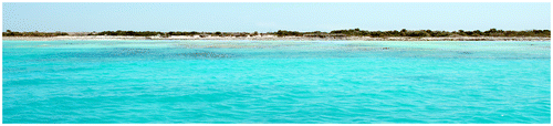
The experience of Dutch seafarers with La Tortuga began on the sea approaching the bay of Punta Salinas, if not before. As they approached the island from the east, the monotonous coastline slowly disclosed exuberantly green vegetation, white sandy beaches and shallow turquoise waters (). This view may have enchanted the newcomers, but the veterans knew it to be a deceitful mirage: the vegetation was mainly fruitless mangroves bursting with clouds of mosquitoes and sandflies, the landscape was sprinkled with spiky cacti and the placid-looking waters were replete with largely unfamiliar and dangerous creatures (rays [Batoidea], moray eels [Muraenidae], and fire coral [Milleporidae]). Somewhere behind the shoreline lay the saltpan, the target of the long and dangerous voyage.
FIG. 6 Panorama of the harbour and the site of Punta Salinas from onboard a ship anchored in the bay
On his map published in 1644, the Dutch geographer Johannes de Laet depicted the routes of five Dutch expeditions to the Caribbean carried out between 1631 and 1633.Footnote45 Four entered the sea via Barbados. Afterwards, the fleets dropped anchor off La Blanquilla Island or the Los Testigos Archipelago because these sites were uninhabited by the Spanish. The voyage from the Lesser Antilles to La Tortuga could last a few additional days. Captain David Pieterszoon de Vries (1593–1662), a Dutch navigator from Hoorn, weighed anchor at Martinique on 11 February 1635 and arrived at La Tortuga on 16 February after spending a couple of days lying off Grenada while looking for salt there.Footnote46
Punta Salinas Bay, La Tortuga, is not a good natural harbour (). De Laet warned his countrymen that ‘the bay being little appropriate [for anchoring], these [ships] can dock [there] only with difficulty’.Footnote47 Staying on board while anchored in the bay was a wearisome experience; the vessel swayed laterally day and night due to prevailing currents. The band of sea bottom appropriate for anchoring runs a few hundred metres from the shore and is relatively narrow. At that point, anchors reach bottom easily; but a few dozen more metres out, and the depth increases abruptly making anchoring impossible. Some visually distinctive elements of the coastal topography (such as especially high mangroves or promontories on the calcareous uplift) had to be memorized in order to fix the best place to drop anchor. The fluits clustered together in the bay formed an interconnected floating settlement.Footnote48 Closer to shore, waters became shallower and patches of corals threatened any small vessel that might attempt to land.
Tangible evidence of salt carrier presence in the bay may be found in the thousands of ballast stones thrown from the ships to make room for salt in the holds of the fluit ships. The Dutch, and later the Anglo-Americans, literally carpeted the bottom of the anchoring area with a layer of allochthonous stones, changing the seabed topography forever.Footnote49 It can reasonably be expected that the stones, bricks or tiles discarded by the Dutch are currently covered with later Anglo-American ballast and trash, making the seabed an attractive option for further underwater research.
Initially the La Tortuga zoutvaerders’ ships were lightly armed. In 1630, only the flagship and the ship of the second officerof the fleet of eight that anchored in the bay were armed, with two cannons each. All ships had swivels, muskets and boarding pikes. A 340-ton fluit, the fleet’s largest, had but one pistol and only the flagship had musketeers on board.Footnote50 The relaxed atmosphere of these early days was well described by a Spanish witness who related that the Dutch ‘put their people on land with so little prevention that they would have been easily overcome by ours […] they are so inebriated with the extracting and loading of the salt that they leave the fluits virtually alone and get to the land unarmed’.Footnote51
This carefree work was short-lived. In 1631, the Governor of the Province of Caracas sent Captain Benito Arias Montano with 40 soldiers and 114 Amerindians armed with bows and arrows to La Tortuga to dislodge the Dutch interlopers. Once on the island, Montano sent a detail to take control of land installations while he led an attack on two fluits anchored in the bay; one of 600 tons with 22 cannons, the second of 300 tons with six cannons. The attackers climbed on board and in hand-to-hand fighting seized control of the ships. Both fluits and prisoners were triumphantly brought to Caracas together with c. 152 metric tons of salt.Footnote52 Back on La Tortuga, the jetty and other installations were destroyed and prisoners taken.Footnote53 This dramatic experience indicated to the Dutch that future salt-raking campaigns would require an armed presence on the island, better-armed convoys, a larger contingent of musketeers and constant patrolling of the surrounding waters (see the ‘battlescape’ section). By 1638 smaller vessels were patrolling the La Tortuga coast, while large fluits were being loaded with salt in the bay.Footnote54 Despite all these measures, the ‘swaying village’ of ships anchored in Punta Salinas Bay could never again feel like a safe extension of the distant homeland.
The activities of each campaign evolved systematically with daily routines oscillating among ships, shore and saltpan. Seen by an observer, these sequences of actions flowing through a series of specific places may be conceived as the chaîne opératoire employed by the Dutch in the salt exploitation process, yet to the Dutch they were engaged in a current of ‘inter activity’.Footnote55 Each daily chapter, as well as each whole extraction campaign, began and ended on board the fluits. Occasionally, visits to the island lasted over two months.Footnote56 Once the fluits dropped anchor, shallops (light sailing boats for coastal transport) were lowered and workers, cannons, timber, wheelbarrows and tools were taken to shore.
The first construction in the bay was probably the wooden jetty. In 1632 it was 100 to 150 paces long and made of strong posts, well-locked planking,heavy beams and decking boards of pine. At its distal end the jetty was equipped with two ladders of five steps each leading down to the shallops. It also featured ‘four portholes through which the salt was thrown’ to four shallops simultaneously.Footnote57 The jetty was secured to the shore through a platform made of planks, its sides tightly wrapped with a fascine made of branches and the interior filled with sand. Traffic to and from the jetty was channelled through an entrywayand two or three cannons lowered from the ships were placed on the platform for the duration of the campaign.Footnote58 Jetties at this location were dismantled by the Spanish in 1631, burnt in 1632 and again in 1638.Footnote59 Today, faint protrusions visible in aerial photographs of the shallow water may mark the place where the jetty was repeatedly rebuilt (). A few ballast stones found underwater at this location may be the remains of the heaps that secured the jetty posts. However, these scarce archaeological remains may also correspond to a later Anglo-American jetty-like structure which most probably had to exist (despite the absence of documentary information) and might have been positioned in the same place as the Dutch structure.
Spanish sources provide the numbers of fluits grouped in Punta Salinas Bay in various years: nine between June and August of 1630, two in 1631, five in September of 1633Footnote60 and eight in May of 1638.Footnote61 Solitary ships avoided stays at La Tortuga due to the threat of Spanish and pirate attacks.Footnote62 Ships anchoring in numbers formed a floating settlement interlaced by loud voices and circulating shallops.Footnote63 The average crew of a La Tortuga fluit numbered 16 men and one boy.Footnote64 With eight ships lying at anchor, the entire Bayscape vibrated with the actions and voices of over 100 men. Except for the captain and musketeers, crew members were engaged in daily activities on land, the hauling of salt to the ships and stowing it in the holds. While waiting for the salt to crystallize, part of the crew dedicated itself to ship maintenance and preparation for the return voyage to the Netherlands. On board, the closeness to personal possessions, the scent of familiar food, the nearness of working companions and the smoking of pipes away from the sun, salt, mosquitoes and sandflies may have made the sailors feel closer to home. A hubbub of activity during the day, the bay transformed into a relatively quiet and safe cradle for the tired men at night (but see ‘panscape’ below).
Once laden with salt, the fluits weighed anchor, set sail and so at last began the long and tiresome voyage home. The mission had been accomplished. However, on each return to La Tortuga, the sight of Punta Salinas Bay was weighted with the memories of companions killed or wounded in the recurring confrontations with the Spanish and their Amerindian allies. The effects and emotions that would have overwhelmed the Dutch zoutvaerders are movingly expressed in the song written by a Dutch sailor from Medemblik who witnessed the slaughter of his companions by Spanish and Amerindian forces on La Tortuga in 1638.Footnote65
PANSCAPE
Originating on the fluits anchored in Punta Salinas Bay, the daily stream of activities first flowed towards the seashore and from there spread on to the saltpan. Once the saltworkers left the wooden jetty and stepped onto the sandy shore, the blazing heat of the interior of the island whipped their faces. Sandflies began to bite them mercilessly, and the reflection of the sun on the white sandy ground suddenly blinded their eyes. The proximity of the saline marshes was signalled by the smell of rotten mangrove leaves. Before them lay several weeks of hard work.
FIG. 7 Panorama of the flooded saltpans of Punta Salinas (photograph, José Voglar).
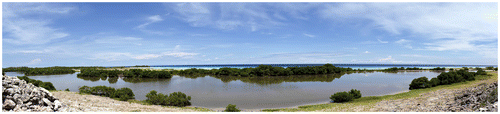
The lagoons of Punta Salinas were flooded by high tides and replenished also by heavy rains (). During April and May of each year at the end of the dry season, the prolonged lack of rainfall allowed water to evaporate from the lagoons producing hypersaline conditions only tolerated by halophytic plants, bacteria and brine shrimp (Artemia salina).Footnote66 Whitish-pink layers of salt crystallized on the surface of the lagoons until new rains dissolved them. The Dutch converted the salt marshes into solar saltpans and Los Mogotes Lagoon became the largest and most productive of these.
In 1626, when Juan Bautista Antonelli (the Younger) reported to the Spanish authorities that the La Tortuga saltpans were not productive enough to sustain large-scale exploitation, the Dutch zoutvaerders were visiting them only sporadically.Footnote67 But by the early 1630s their visits had become regular and the complexity of their saltworks increased. The report of the Spanish shipwrecked seaman Seledón de Suasola offers a detailed account of the volume of salt loaded by the Dutch from La Tortuga between June and August of 1630.Footnote68 Suasola counted c. 1,000 heaps of salt piled on the saltpan, the result of eight days’ work by the crewmembers of but one fluit which appeared a week before six others arrived. The heaps contained 10,940 wheelbarrows of salt averaging 50.5kg each, totalling c. 553 metric tons of salt. When no salt was left on the surface of the saltpan, more had to be produced. Suasola observed how the Dutch, using a type of tray (probably a wooden pan), poured seawater onto the saltpan for eight consecutive days. Given high temperatures, clouds of sandflies and permanent contact with salt and hypersaline water, this work had to be tedious and wearing in the extreme. Some 30 years before, Juan Bautista Antonelli (the Elder) had observed how saltworkers in Araya were active mornings and moonlit nights only, avoiding the hottest part of the day.Footnote69 It is very likely that the La Tortuga Panscape was similar, teeming with action and resounding with the creaking of wheelbarrows and the clatter of clogs on wooden boardwalks. During moonlit nights boisterous cheers ricocheted off the cliff walls and pipe bowls flickered everywhere like fireflies. Despite this relaxation, the harshness of the saltwork claimed human lives. A small Dutch cemetery with wooden crosses was situated on the dune rising above the Araya saltpan;Footnote70 burials might also have existed on La Tortuga where today there are crosses erected by fishermen on the site of Punta Salinas.
Suasola reported that while the water was evaporating and the salt was crystallizing, men with shovels were extracting the same mineral from subsurface layers in other parts of the saltpan. In six days of work, 1,148 wheelbarrows of this latter salt were gathered (c. 56 metric tons). Suasola related that this shovelling labour was especially gruelling. Nearly four weeks later, by 28 June 1630, salt had already crystallized again in the formerly flooded part of the saltpan. This was piled up over eight days, and during the following twelve transported to the jetty. Some 14,000 wheelbarrow loads (c. 707 metric tons) were loaded onto all seven fluits. The process was then repeated: the saltpan was inundated, salt crystallized and was heaped in eight more days, and over the next nine some 606 metric tonswere transported in 12,000 wheelbarrow trips to the jetty and onloaded. Over two and a half months, Suasola witnessed a total of 28,344 wheelbarrow loads or c. 1,431 metric tons of salt gathered, transported across the La Tortuga saltpan, and loaded onto the seven Dutch vessels.Footnote71
How did the zoutvaerders distribute the salt among the ships? How did they determine the access of each crew to each part of the saltpan? At Araya, crews from different Dutch towns used their own tools. They separately constructed, maintained and used their own boardwalks, midday shelters and flat-bottomed floats to transport salt across flooded areas. The jetty was the only installation that was jointly constructed, maintained and utilized.Footnote72 According to Suasola, all seven ships present at La Tortuga between June and August of 1630 belonged to the same four salt merchants despite coming from two different Dutch towns.Footnote73 This mercantile arrangement most probably evolved under the aegis of the WIC. It may have meant that the La Tortuga saltpan did not have to be partitioned, but was instead exploited cooperatively. Despite the fact that the crew of a fluit which had arrived a week before the remaining six had gathered all the salt from the surface, the other crews helped with the onloading. New salt subsequently produced was distributed among all the fluits, including the first (topping off its load). It could have been that the ‘rights’ of certain towns or merchants to La Tortuga salt resulted in coordinated crew activity on the island. Plausibly, over the years to come, all the Dutch on the island worked harmoniously for the success of the total mission.
But the Spaniards did not leave the Dutch in peace to extract salt from under their noses. In 1631 the captain Benito Arias Montano, acting on behalf of the Governor and Captain of the Province of Caracas, seized two fluits with c. 152 metric tons of salt at La Tortuga.Footnote74However, in October of 1632 Jacinto de Amaya, who had accompanied Montano as a soldier in 1631, was sent back to the island and reported that all the facilities dismantled by Montano had not only been rebuilt but vastly improved.Footnote75 The path of c. 250m between the jetty and the saltpan was entirely covered with 0.42m-wide pine planks, well-fitted and nailed together. Water bucketing was replaced by six manually operated pumps drawing from the sea, which were most probably versions of the well-known ship bilge pump. Towards the centre of the saltpan, Amaya saw another five pumps distributing water into various sections. All activity areas were interconnected by a boardwalk network.Footnote76 The Dutch, absent during Amaya’s visit, had left the pumps and other facilities ready for the next campaign despite the fact they could easily be destroyed by the Spanish. In fact, soon after Amaya’s visit, militiassent by the Governor of Cumaná destroyed and burnt them.Footnote77
In September of 1633 Montano appeared again on La Tortuga, killing some Dutchmen and causing eight fluits to flee. On this occasion Juan Bautista Antonelli (the Younger), accompanying Montano, reported that the saltpan — according to ‘precise measurements’ — had become so transformed and artificially extended beyond its natural borders that its circumference had increased from over 4,000m in 1626 to over 10,000m. All these ‘improvements [were] done with curious and incredible work’ and received Antonelli’s highest admiration.Footnote78 The huge input of hard labour in natural conditions so harsh as to be nearly inhuman converted the undervalued ‘natural’ Los Mogotes Lagoon into a highly productive saltpan leaving visible geomorphological impressions. Antonelli provided a description of the spatial organization and methods applied in the saltpan:
From the jetty to the salina they [the Dutch] built some boardwalks where the salt is carted in small wheelbarrows of one wheel, operated by a single man. The entire saltpan is divided and tilled by hand. It has some eras [flat, square, firm and clean pans] of 40 by 70 paces [55 × 97m], some longer and some shorter, all very flat and levelled. Alongside these eras there are streams or channels through which the water is conducted to the eras for the benefit of the salt production. At intervals along these channels there are some small water reservoirs from which a man with a device throws the water into the eras. The beneficial result — and how salt is made — is that with this device they throw into those eras 1 or 2 fingers [1 finger = c. 19mm] of water and after six days the salt is crystallized and ready. Afterwards, the salt is piled in the eras with a rodillo [flat toothless rake], making small piles and later from these small piles the salt is taken outside the eras making a large heap, where it dries and the water from the eras that it contains is drained from it. From these large heaps the salt is transported in wheelbarrows to the jetty from which it is later loaded onto the ships. As they load the wheelbarrows, they do the abovementioned procedure [in the eras] every week so that all the eras can produce, each week, 12,000 bushels of salt [606 metric tons]. All eras together can load 30 to 40 ships and in the meantime new ships may enter the bay and can also be benefitted [receive loads of salt].Footnote79
The above passage indicates that after the destruction of the pumps in 1632, the Dutch returned to manual water bucketing but installed a complex system of channels, water reservoirs and saltpans (eras) of levelled ground for salt-making. But Antonelli had arrived in 1633 to sabotage the enterprise through an elaborate plan to flood the saltpan, and he had the necessary workforce and tools to do it.Footnote80 One hundred Cumanagoto Indians and 50 Spaniards began work at the point in the lagoon where the water table level was 0.81m to 1.09m above the bottom of the saltpan. From there, they dug two canals to the seashore 100m away. All men close to the beach worked in a coordinated manner in order to break through the last sand barriers simultaneously at high tide. Water entered and inundated the entire lagoon. Antonelli calculated that even at low tide the saltpan would be covered with roughly a metre of water and, that with the larger lunar tides, water would enter and leave the lagoon with the violence of a river. Due to this periodic scouring effect, the canals would perpetuate themselves.
Antonelli suspected, nevertheless, that the next Dutch crews to arrive would attempt to close the canals. But he argued that even success in such an endeavour would be unproductive in the short term as the inundated saltpan would need at least six months to drain, after which the bottom would require the further step of manual cleaning to eliminate sludge since salt could not have crystallized underwater. His predictions were more than correct. The large Dutch saltpan was permanently converted into the much more biotic Los Mogotes Lagoon, the bottom of which filled with a thick mat of organic detritus. Antonelli suggested that the governors of Margarita and Cumaná keep systematic watch to prevent the Dutch from closing the canals to the sea. If closed, he recommended that six piraguas carrying 50 Amerindians and 20 Spaniards could reopen them with two days’ work. Not inundating the La Tortuga saltpans, Antonelli concluded, would be to waste all previous efforts to dislodge the Dutch from Araya and Saint Martin. At the same time, he warned that drastic measures had to be taken against the Dutch exploiting the Unare saltpan.Footnote81 Meanwhile, his flooding operation, as noted, achieved its goal. Reports by Montano’s periodic emissaries show that large-scale Dutch exploitation ceased, not to be reattempted until a brief and violent episode in 1638 (to be detailed in the next section).Footnote82 That episode and its aftermath resulted in new anthropogenic modifications to the saltpan area.
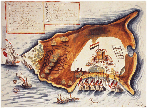
The map of the 1638 skirmish shows the artificial canal connecting the Los Mogotes Lagoon with the ponds to the west ().Footnote83 The dimensions of the formerly salt-producing Los Mogotes Lagoon were diminishing due to the cessation of salt production. The lagoon was, however, still valuable as a reservoir of hypersaline water. The map caption indicates that through the ‘small canal [the Dutch] fed [the new adjacent] saltpan [with seawater]’ (). Towards the west, the canal opens onto a rectangle with 15 quadrangular subdivisions. Together they constituted the artifice ‘through which [the Dutch] made profit from the saltpan’. This artifice consisted of levelled square pans similar to those mentioned above by Antonelli in 1633. By conveniently closing or opening the canal by means of a wooden sluice, the pans to the west could have been inundated or left to dry out as needed.
We may hypothesize that once the Los Mogotes Lagoon was permanently connected to the sea in 1633, the Dutch began to use it as a large reservoir of saltwater and connected it to the smaller lagoon to the west. Once again, the industrious Dutch managed optimal output from the Spanish damage. The once-neglected smaller ponds were converted into the Panscape that hosted the activities and artifices formerly concentrated in the Los Mogotes Lagoon area.
We may also hypothesize that the canal visible today between the Los Mogotes Lagoon and the smaller lagoon to the west, flanked by rows of tall withered mangrove trees, is a remnant of work performed on the previous Dutch canal by Arias Montano’s 1638 expedition (). Montano himself mentions that at that time, they ‘returned to flood the pans’.Footnote84 However, it would have been unreasonable for Montano to excavate a long canal from the new western saltpan to the sea because the inundated Los Mogotes Lagoon, adjacent to the east, was already an extension of the sea.Footnote85 We suggest that in 1638 the Cumanagoto Indians, supervised by the Spanish, greatly enlarged and deepened the small connection made by the Dutch between the two lagoons in order to thoroughly and permanently flood the newly created saltpan, just as had been done to the Los Mogotes Lagoon five years earlier. This new work site was particularly difficult. It was distant from the seashore in a boggy semi-inundated area, covered with mangroves and infested with insects.Footnote86 Artefactual evidence that would account for the presence of Spaniards and Amerindians in the saltpan area is absent.Footnote87 If such remains once existed they might have disintegrated due to the corrosive hypersaline environment. More surprisingly, no artefactual evidence has emerged from all the Dutch involvement in the saltpan area. This absence may partly be explained, however, by the renowned Dutch orderliness,Footnote88 which may have prevented a whole range of materials from being accidentally mixed with the precious ‘white gold’.
FIG. 8 Map of Dutch fort on La Tortuga under attack by Spanish and Cumanagoto Indians painted by Juan Bautista Antonelli (the Younger) in 1638 (España, Ministerio de Educación, Cultura y Deporte, Archivo General de Indias, AGI, MP-Venezuela, 24 – Planta de la Isla Tortuga (1638)).
Today, the salt marshes of Punta Salinas form a landscape of abandoned saltpans. Although a systematic study of the vegetation and ecological gradients of the saltpan is a matter for future research, we suppose that in the Dutch and Anglo-American time periods, this area was considerably less covered by mangroves than it is today. The ample mangrove swamps that extend to the south of the Los Mogotes Lagoon are probably the consequence of Antonelli’s and Montano’s combined work in permanently connecting the two adjacent lagoons to the sea. The constant influx of seawater lowered the salinity of the water and soil in these lagoons and their immediate surroundings. Beginning with mangroves, this led to a succession of plant communities in the intertidal zone around the margins of the lagoons including patches of Sesuvium portulacastrum and Batis maritima in the upper strata. But in the former open landscape, processions of silhouettes topped with broad-brimmed hats bent over heavy wheelbarrows burdened with salt were clearly visible as they moved along the boardwalks. Some archaeological remains of the Panscape may eventually be found under the thick layer of mud at the bottom of the Los Mogotes Lagoon.
BATTLESCAPE
In the discussion of the Bayscape and the Panscape, we saw how the Dutch interacted with one another and with La Tortuga’s harsh marine and terrestrial elements, as well as its climate, in the pursuit of their salt extraction enterprise. Here we will discuss how they also interacted with the Spanish and Amerindians from the adjacent mainland. Especially after 1630, the zoutvaerders were repeatedly observed and attacked, and their installations on the island were repeatedly destroyed by the Spanish militia and their ethnic soldiers, the Cumanagoto Indians.Footnote89 This section begins with the description of armed skirmishes at Punta Salinas, and follows by mobilizing the pertinent archaeological evidence giving flesh to the Battlescape.
In 1630, Captain Benito Arias Montano, accompanied by 24 Spaniards and 50 Amerindians, intended to raid the Dutch interlopers on La Tortuga. However, arriving on the island, he found the saltpan abandoned.Footnote90 A year later Arias Montano returned with 40 Spanish soldiers and 114 Amerindians in six piraguas.Footnote91 Two Dutch fluits anchored by the saltpan were subdued and installations on land were seized.Footnote92 In 1632, the Dutch constructed an earthen platform uniting the jetty with the shore and equipped it with ‘three cannon emplacements, one facing the ship anchorage, the other the salinas and the other the hill from where they [the Dutch] were attacked last year’.Footnote93 This facility was burnt by the Spanish that same year.
In July 1633 the Governor of Margarita, Don Juan de Eulate, sent his son Juan Alvarez and an unknown number of Spaniards and 60 Amerindians in three piraguas against 18 Dutch fluits loading salt on La Tortuga. The Dutch were defeated; the Spanish seized one fluit, killing the captain and 17 Dutchmen.Footnote94 In November of the same year, a new attack led by Arias Montano — newly appointed Governor of the Province of Nueva Andalucía — left an unspecified number of Dutch interlopers dead. The documents describing both these skirmishes of 1633 do not mention defensive structures or cannons on land.
The year 1633 was a difficult one for the zoutvaerders, and not only on La Tortuga; in June the Dutch were expelled from Saint Martin,Footnote95 and in August from Unare.Footnote96 The unrelenting Arias Montano led all of these expulsions. In light of these setbacks, in a meeting on 6 April 1634, the WIC ‘approved the takeover of the island of Curacao’ in order to have a place from which to acquire ‘salt, wood and other products’.Footnote97 However, despite the considerable efforts dedicated to exploiting salt on Curaçao, the Dutch could barely supply local demand.Footnote98
In 1638, the Dutch were back on La Tortuga and in early May of that year the Spanish were informed that eight fluits were loading salt there. Soon after, a fleet of 13 piraguas with 150 soldiers and 150 Amerindian archers and rowers led by Arias Montano left Cumaná. Navigating along the leeward coast of La Tortuga, the fleet arrived unnoticed at the island’s western point.Footnote99 But there, the attackers were spotted by a Dutch lookout ship whose sailors then sailed hastily towards Punta Salinas Bay to alert their companions. Shortly thereafter, three small reconnaissance boats appeared on the windward side of the island. Arias Montano seized one while the remaining two escaped.Footnote100 The prisoners provided information about the Dutch forces on the saltpan. The next day, before dawn, Arias Montano and his companions waited in ambush just 200 paces east of the wooden fort that the Dutch had erected by the saltpan. At sunrise, the Spanish and their Amerindian allies attacked. They stormed the fort for four hours under cannon and musket fire from both the fort and the Dutch fluits.Footnote101 At around ten o’clock, before the sun’s heat became unbearable, the attackers opened a breach in the wall of the fort with their axes. They entered and slaughtered the 40 men in the garrison, sustaining a loss of seven soldiers and four Amerindians with 20 wounded. The following is Arias Montano’s description of the Dutch defensive structure:
The fort was a square, made with boards half a yard [c. 420mm] thick and filled with [coral] stones; it was 21 feet high [5.84m] from where the infantry fought; the eight cannons it had, two on each side, were planted on the ground below; and it had a stockade about one story [c. 1.95m] high and beyond it many boards nailed with iron barbs.Footnote102
After the battle, while the fluits hurriedly took sail and departed, Arias Montano burnt the fort and the jetty and destroyed the saltworks.Footnote103 Eight cannons (one of them bronze) were transported to the continent and installed in the fort in Araya. Dutch salt extraction on La Tortuga had finally come to an end.
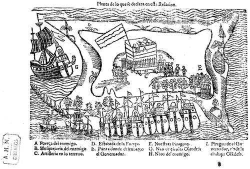
The Spanish document and map from 1638,Footnote104 which narrate and illustrate the 1638 battle, inspired and guided the 1992 archaeological survey of La Tortuga (). These sources enabled the delineation of the Punta Salinas site.Footnote105 After that, the landscape of the island was gradually experienced by the research group. The Dutch activity area and the emplacement of the wooden fort were finally located in 2009 (see below). The Spanish map, and its engraved version printed in 1639,Footnote106 are the only available iconographic windows onto the events of 1638 (). The maker of the original map, the military engineer Juan Bautista Antonelli (the Younger) presents a specific conception of space, drawing attention to the saltpan area by disproportionately oversizing it in respect to the overall size of the island. In the tiny brushstrokes, we can recognize vividly rendered people in action. They surround a wooden fort with cannons, from which musketeers fire their weapons; a flag waves in the breeze. The fluits anchored in the bay also participate in the fever of fighting. The battle evolves before our eyes and indeed, affects us. We can almost hear the shouts, the thunder of the cannons and the whizzing of the musket balls.Footnote107 In the foreground, we can observe piles of salt and the abandoned saltpans.
FIG. 9 La Tortuga skirmish of 1638 depicted on a map printed in Seville in 1639 (España, Ministerio de Educación, Cultura y Deporte. Archivo Histórico Nacional, AHN, Diversos-Colecciones, 26, N.81).
Here we turn to the examination of the archaeological features located on the Punta Salinas site, and discuss which of them may correspond to the emplacement of the wooden fort from 1638. Feature TR/S/T-1 consists of a diamond-shaped earthwork of sand, 20 × 19m, with a maximum elevation of 1.25m above sea level (). Although routine shovel test pits had been excavated in this feature before, it was in 2009 that a new test pit excavated in the central part of the earthwork yielded the first Dutch artefacts recovered on the island.Footnote108 The test pit presented a feature of conical shape and circular cross section with a diameter of 750mmin its upper part. The feature extended to a depth of 800mm and was composed of sand darker than the surrounding matrix. It contained twelve fragments of Dutch pipe stems and four pipe bowls as well as a fragment of a porringer. These fragments were dispersed randomly along the column of sand at depths between 250 and 800mm. The feature was interpreted as a possible rubbish pit or a post hole associated with the fort’s main supporting structure. Further excavation enlarged the test pit to 2 × 2m, but no other remains or such features were found.
On the eastern flank of the earthwork a 45-square-metre trench was excavated, revealing that the earthwork originated from a coastal dune which was artificially modified (). The resulting earthwork was the highest ground on Punta Salinas. The earthwork was surrounded by a metre-wide ditch on all four sides. However, it is uncertain whether this ditch had specific defensive purposes. We suggest that, guided by the structural principle of Dutch orderliness, the zoutvaerders on La Tortuga replicated the basic fort design using the simplest techniques and materials. Dikes with floodgates, water-filled moats and canals were the basic elements of Dutch military defence constructions of the time.Footnote109 It seems possible that the ditch was originally excavated down to at least the water table level. Such a mini-moat was more of a deterrent than a real defensive measure.Footnote110 However, it may also be argued that the effectiveness of the ditch might have surpassed mere deterrence because it was positioned bordering the high palisade mentioned in the sources.
FIG. 10 Plan of the excavations carried out at the Dutch features TR/S/T-1 and TR/S/T-2 and their profiles.
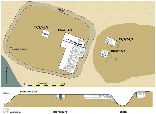
FIG. 11 Partial view of the 2010 excavation of the earthwork feature (photo, José Voglar).
The first 100mm of loose sand in the trench yielded a few fragments of 18th-century artefacts which could be associated with Anglo-American exploitation of the saltpans. The majority of the Dutch-related potsherds were recovered at depths between 200 and 400mm and lay in a sandy matrix amongst coral stones towards the eastern edge of the earthwork. Towards the centre of the earthwork ceramics were virtually absent, but several fragments of Dutch pipes and rabbit bones appeared at depths between 200 and 400mm. Small scatters of Amerindian potsherds, as well as shell and stone artefacts, were found at depths between 300 and 500mm. The Amerindian component was most probably present in the coastal dune before the Dutch converted it into the earthwork.
Aside from the aforementioned pit feature, no postholes were identified in the trench excavated on the earthwork. This may be due to the fact that the very loose sandy matrix of the site was not conducive to preservation of such features, as horizontal and vertical movement of the matrix over time may be considerable. Alternatively, this may also be due to sampling bias, and future excavations may yield postholes.
A sandy ridge of irregular shape (TR/S/T-2), with an elevation of 1.49m above sea level, extends immediately to the east of the earthwork (). Its anthropogenic origin is doubtful, although several large coral stones found on top of it were probably placed there intentionally. Dark patches of ash visible among the semi-interred stones represent the remains of fireplaces, suggesting that the stones were used as a windshield. Fragments of 18th-century Anglo-American artefacts were found on the surface and to a depth of 200mm. Such fragments were also found in the test pits excavated in the western part of the ridge. Fragments of Dutch pottery, pipes and faunal remains were recovered at depths of between 200 and 550mm. Both the artefacts and ecofacts seemed to be randomly dispersed in the matrix, similar to their disposition in the adjacent earthwork. No Amerindian cultural layer was found; only a few dispersed Amerindian potsherds were encountered.
The ridge is separated from the earthwork by the ditch. The slopes of the earthwork and the ridge that rises from the ditch are parallel. The abundant coral stones in this location suggest the remains of an embankment. Fragments of Dutch potsherds pertaining to the same vessels were recovered both in the earthwork and in the ridge, indicating that the two formations constituted a continuous dune formation that was cut through by the ditch. During the original excavation of the ditch, sand may have been thrown to both sides. This would account for the dispersal of the pottery fragments encountered, and might indicate that this site was utilized by the Dutch prior to the earthwork.
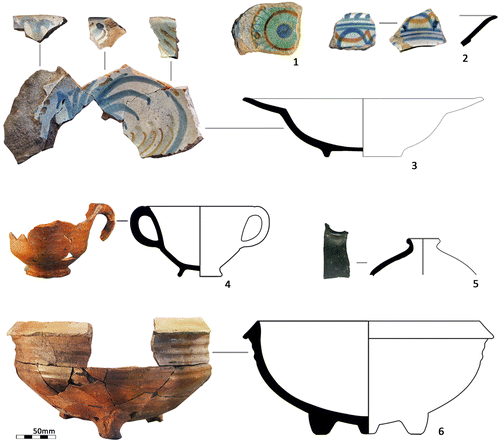
The pottery assemblage encompasses 132 fragments (114 from the earthwork and 18 from the ridge) and a minimum of 20 vessels. Three complete vessels could be reconstructed. The first is a brimmed dish, probably of Mexican majolica and attributed to the San Juan Polychrome style ().Footnote111 The remaining two vessels are Dutch lead-glazed red earthenware. The first of these is a two-handled porringer with a thick green glaze on the interior,Footnote112 and the second is a tripod saucepan ().Footnote113 Red earthenware sherds include rims and handles which, taken together, show that at least eleven other vessels of this type were used at this site including a skillet, jugs, jars and two other tripod cooking vessels.Footnote114 Of the 20 vessels, only six were examples of tableware, with two polychrome Dutch tin-glazed earthenware dishes standing out amongst them. One featured blue dashes on its rim and interlaced blue and orange curved lines below ().Footnote115 The other is a fragment with a blue, green, yellow and orange rosette in the centre ().Footnote116 The majority of vessels were storage- and cooking-wares (N=14), suggesting that some of the meals the Dutch consumed might have been prepared on site. Ceramic liquid containers are represented by two fragments of a German brown stoneware Bartmann bottle. Two identifiable glass bottle fragments that can be attributed to the Dutch occupation of the site include a Belgian ‘case’ bottle with a short restricted lip and black metal (), as well as a possibly Belgian vial with a short neck and flared finish of olive-green metal.Footnote117 A fragment of melted olive-green glass, unassociated with any hearth, was also found. This might be a product of Arias Montano’s burning of the fort once he had defeated and killed the Dutch garrison. Five fragments of mica sheets, possibly Muscovy glass, suggest that a lantern might have been lowered from the Dutch fluits for night-time illumination.
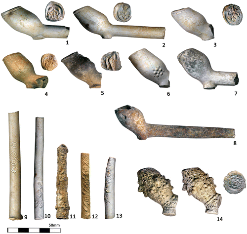
FIG. 12 Ceramics and glass recovered in the earthwork feature (TR/S/T-1). 1–2. Dutch tin-glazed earthenware dish fragments; 3. brimmed dish probably of Mexican majolica and attributed to the San Juan Polychrome style; 4. Dutch lead-glazed red earthenware two-handled porringer with a thick green glaze on the interior; 5. Belgian ‘case’ bottle fragment; 6. Dutch lead-glazed red earthenware tripod saucepan.
The earthwork yielded 125 fragments of Dutch pipe stems.Footnote118 Eighteen presented a stamped decoration of a lily within a diamond as well as moulded stylized floral motifs (). The ridge yielded 28 stems including eight decorated with similar motifs. Thirty bowls and bowl fragments were recovered from the earthwork and eight from the ridge. The majority of the bowls feature rouletted rims and marks stamped on the heels, including a rose, a tulip, a crowned rose and a lily; makers’ marks are present on some of these (). Several of the bowls have plain rims and flat and undecorated heels. Upon close inspection, eight of the stems also present clear bite marks. Most of these pipes were probably produced in Amsterdam, a dominant clay pipe production centre of the period, and can be dated to between 1625 and 1638 (the latter is the terminus ante quem for the Dutch archaeological component on La Tortuga).Footnote119 A few pipes were made in West Friesland (Hoorn/Enkhuizen) and Gouda during the same time span (). One fine pipe bowl, decorated with baroque motifs of human faces, a rooster’s head and floral design, is a rare example ().Footnote120
FIG. 13 Dutch pipes recovered in the earthwork feature (TR/S/T-1), dating between 1625 and 1638. 1. pipe with a rose mark, prob. Amsterdam; 2. Gouda pipe with a tulip mark; 3. Pipe with a crowned rose mark flanked by ‘T’ and ‘T’, Amsterdam; 4. pipe with a crowned rose mark, Amsterdam; 5. double-conical pipe with a lily mark, prob. Amsterdam; 6. pipe with molded rose on bowl; 7. West-Frisian pipe (Hoorn/Enkhuizen); 8. Poss. West-Frisian pipe; 9–13 various molded and stamped pipe stems, mostly from Amsterdam; 14. rare and finely molded pipe bowl with baroque motifs of human faces, a rooster’s head and vegetal design, poss. Gouda (Jan van Oostveen pers. comm. 2010).
Faunal remains are dominated by rabbit (Genus Sylvilagus) bones which account for 374 specimens (Number of Identified Specimens) in the earthwork and 137 in the adjacent ridge. The minimum number of eighteen individuals was established from the count of right pelvis fragments in the earthwork and the ridge. Three pelvic bones from the earthwork show marks from the cutting action of knives; the marks are patterned on two of these bones. The earthwork and the adjacent ridge are the only places in the whole archaeological site of Punta Salinas where these bones were found, and are also associated with Dutch pipes and pottery.Footnote121 This indicates that the Dutch consumed rabbits in situ. Nevertheless, the question remains open as to whether these animals were brought from the Netherlands or captured on the island. Although some sources may favour the first scenario,Footnote122 16th-century Spanish documents mention the presence of rabbits on some islands located off the Venezuelan coast.Footnote123 Indeed, the coastal dunes on Punta Salinas provide an environment where these animals could burrow.
A further 28 mammal bones indicate that beef and pork were also consumed. The remains of wild goats have not been recovered thus far. This suggests that once hunted in the interior of the island (as mentioned by Seledón de Suasola), goats were taken on board the fluits for butchery, preparation and consumption.Footnote124 Avifauna is represented by 43 bones, among which the presence of pelicans (Pelecanus occidentalis) can thus far be confirmed.
Local marine fauna are poorly represented, and this is not due to preservation and soil acidity as marine fauna remains were found in large numbers in the adjacent portions of the Punta Salinas site associated with the later 18th-century Anglo-American activity. Among 36 fish remains recovered from the earthwork, the majority are unidentified spines and vertebrae. Two spines with hyperostosis probably belonged to medium-size jacks (Carangidae). Two otoliths of snappers (Lutjanidae) and one of a grouper (Epinephelidae) pertained to medium-to-large specimens. Grunts (Haemulidae) are represented by one otolith, and one premaxilar of a porgy (Calamus sp.) was also recovered. All these fish could have been captured by hook and line directly from the fluits, or from the storm terrace close to the site.Footnote125 Molluscs from the earthwork include three shells of subadult queen conch (Lobatus gigas), a few broken nodules, and one apex of the same species. One or two shells of the following molluscs were also recovered: Cittarium pica, Natica canrena, Cypraea sp., Oliva sp., Conus sp. and Cassis sp. Two dozen chiton (Polyplacophora) plates were identified. Six opercula of Litophoma sp. and fourteen valves of Tivela mactroides complete the sample. Almost all of these species can be easily collected along the nearby coast. Intriguingly, sea turtle bones were not recovered except for three small fragments of charred carapace.Footnote126 The collection of marine animal remains is complemented by single fragments of a lobster and of an unidentified crab.Footnote127
Incorporating faunal remains into the contextual matrix of the site leads us to interpret them as food remains left by musketeers guarding the fort.Footnote128 They probably ate meals prepared on the fluits and then brought to shore, although some foods may have also been prepared on the ridge (TR/S/T-2) adjacent to the earthwork (as suggested by the presence of a skillet and various cooking vessels). No Dutch fireplaces were found; lighting fires close to the fort, which contained stores of gunpowder, was dangerous and indeed likely prohibited. The diet of the musketeers — and by extension probably the rest of the crews — was based on provisions brought from the Netherlands which left no material traces in the archaeological record. Inclusion of local marine fauna in the diet was negligible, perhaps because of the fear of poisoning.Footnote129 The available introduced animal species such as goats and rabbits — well known from the Dutch homeland — were hunted over a period of time. The goats were hunted in the interior of the islandFootnote130 and the rabbits could easily have been trapped with nets when smoked out of their coastal dune warrens.Footnote131
Remains of metal tools and utensils are rare in the earthwork. Six heavily corroded iron fragments of ladle or knife handles were recovered (). A small fragment of a possible colander was also encountered. The excavation yielded 20 corroded nails with lengths varying from 3.6 to 12mm. Another sixteen fragments of nails, which were still attached to tiny fragments of wood, could be the remains of a chest, chests or a coffer. Judging by their deposition, some of the nails may pertain to the Anglo-American period.
Fragments of arms and ammunition were also recovered from the earthwork. However, their attribution to the Dutch period is problematic. Judging by the context of deposition, a possible iron butt plate might have been hardware from a Dutch musket. Some of the copper-alloy trigger guards and ramrod pipes recovered in different spots across the Punta Salinas site may also pertain to the Dutch period. Two possible gunflints were found in the earthwork and, if such, would pertain to the later Anglo-American phase of the site as flint-lock weapons were not yet in use in the 1630s, with the firing mechanisms then being predominantly match-lock or wheel-lock (). Alternatively, these may represent flint fire-starters used by the Dutch.
Two iron cannonballs were recovered in the earthwork at a depth of 320 and 400mm.Footnote132 Both artefacts are spherical, heavily corroded and concreted, and feature large and deep fractures. The cannonballs are currently 150mm in diameter due to the expansion of the corroded iron; however, originally they were probably significantly smaller, possibly c. 90mm in diameter. The archaeologically recovered artefact weighs 2.85kg. Ammunition of similar size and weight can be attributed to small portable cannons such as the swivel gun (the Spanish pedrero), minion cannon or saker.Footnote133 They were used on both ships and land due to their portability.Footnote134 Dutch cannons were fired on La Tortuga in 1633 and 1638, and the recovered cannonballs can be attributed to the Dutch period on the basis of the context of their recovery. Due to their poor state of conservation, it is impossible to determine whether they were impacted or not. Probably they were part of the ammunition of the Dutch fort and were never fired.Footnote135
FIG. 14 Metal and stone artefacts recovered in the earthwork feature (TR/S/T-1). 1. various calibres of lead shot, both impacted and intact; 2. flint fire-starter or a gunflint of a later period; 3. iron ladle or knife handle; 4. Spanish lead cloth seal; 5. lead cloth seal of unknown provenance, length:45mm.
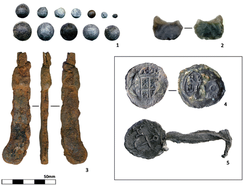
A total of 274 lead shot pellets of diverse calibres, both in good-to-unused and impacted condition, were recovered from the Punta Salinas site (). Their calibre and weight range from 0.7mm and 1.47g to 18mm and 34.26g. In contrast to the cannonballs, the lead shot pellets are in relatively fair condition. Many show melding or casting lines and sprue remains. Lighter ammunition are possibly for fowling pieces and pistols. Larger balls, with diameters of 15–18mm, can be more securely be ascribed to matchlock muskets. These military firearms were used on La Tortuga, especially during the battle of 1638. There are 154 larger-diameter balls, 112 of which are not impacted, 14 show diverse effects of impact while the condition of the remaining balls cannot be conclusively determined. The unimpacted balls were probably dropped and lost before they could be used. Nineteen 18mm balls were recovered in the earthwork and six on the adjacent ridge (TR/S/T-2). Only two were impacted; the remaining 23 were probably dropped and lost before they could be used. Three shot pellets of the same calibre, found together, were also discovered on the ridge in close proximity to one of the cannonballs. The majority of these 18mm balls were most probably the ammunition of the Dutch musketeers. The remaining smaller pellets were found dispersed across the surface of the site up to the line of mangroves towards the north. Remarkably, shot was not found along the coastline proper to the east, south and north-east of the earthwork. This spatial distribution seems to suggest that musket fire was directed from the south and south-east towards the north and north-west, a line of fire roughly corresponding to the 1638 Spanish attack, which came from the south-east towards the Dutch musketeers’ defensive position in the fort.Footnote136 This also concords with the overall object and feature distribution patterns at the Punta Salinas site. In addition, the distribution pattern aligns with the images depicted on the Spanish historic maps.
Two lead cloth seals were found at Punta Salinas, and at least one can be attributed to the Dutch period. It is a Spanish seal that was found on the surface to the west of feature (TR/S/F-2) (). Although it has not been conclusively dated, it is possible that it represents what remained of the cloth merchandise that was washed ashore when the Spanish registry ship (sent to supply Caracas) on which Seledón de Suasola was a seaman was wrecked on La Tortuga’s northern coast in 1630. The Dutch probably brought the merchandise back to the site of Punta Salinas after recovering what remained; as Suasola reported, ‘the pilot of the [Dutch] ship which was second-in-command came with the deponent and four musketeers to the place where the vessel had been wrecked; […] and having found some merchandise in the water that had come to shore […] after having picked up the clothing on shore […]’.Footnote137 The other cloth seal, found in the earthwork feature, has yet to be identified ().
Although the relationship between the earthwork and the wooden fort of 1638 is not straightforward, we argue that the overall size and form of the earthwork and the conspicuous presence of Dutch artefacts in it indicate the place where the fort was erected. The hundreds of coral stones accumulated on the eastern border of the earthwork may be remnants of the fill that was used between the two sets of planks forming the walls of the fort. Moreover, if the fort was situated on the earthwork, then the adjacent ridge might have had a simple shelter on its top where the musketeers could rest in the shade, eat and smoke their pipes (). Here they would have been close to the fort yet far enough away from the dangerous stores of gunpowder. Ranjith Jayasena has pointed out that similar military sites were usually kept clean, with the exception of clay tobacco pipes that were typically found at Dutch 17th- and 18th-century forts.Footnote138 Furthermore, as previously mentioned, there are a few wooden crosses on Punta Salinas, erected by contemporary fishermen. One set of these is located on the south-western corner of the earthwork (see ) and may possibly be where the Spaniards interred some of the Dutchmen killed in the 1638 skirmish. Analysis of this possible burial awaits future research.
A final feature (TR/S/Ft-A) begins 30m north of the seashore and 95m west of the previously described earthwork (Fig. 5). It is an elongated heap of loosely piled coral stones parallel to the shore, 0.8m high and 9m long. Ten metres further to the north lie three similar heaps arranged in the form of a rectangular enclosure but without a western side (TR/S/Ft-B). Each heap is 0.9m high and 10m long. The heaps lie on top of an esplanade of compact sand flanked by two small ponds. Immediately west of the structure,a path of compact and non-vegetated sand stretches from the seashore towards the interior of the plains ().
Archaeology sheds little light on the origin and potential function of the stone structures and the underlying esplanade for either the Dutch or the later Anglo-American entrepreneurs (or both). The surface survey yielded a few fragments of 18th-century glass bottles and stoneware as well as some unidentified iron fragments. Similar objects were also found at the basal portion of one of the coral stone heaps. Test pits excavated throughout the esplanade exposed compacted sandy matrix interspersed with small coral stones extending from the surface to the water table level. Neither artefacts nor ecofacts were found in the test pits, with the exception of six randomly dispersed pellets of lead shot.
How does the feature TR/S/Ft-A stand in the light of the documentary data? We know that the Dutch (and the Spanish and their Amerindian allies too) modified the topography of the Punta Salinas site in order to accomplish their purposes more efficiently. We may hypothesize that the 1632 earthen platform described in the sources might have been located south of the stone structures just at the point of articulation between the beach and the jetty; the original position of the jetty seems suggested by the shadowy protrusion visible on the aerial photographs (). The long boardwalk, also mentioned in the sources, could perhaps have followed the path beside the structures reaching the saltpans in the background (). Indeed, this hard-packed path is the most convenient track between the seashore and the western lagoons. It might have been in use after the Spanish inundated the first large saltpan (today Los Mogotes Lagoon) in 1633. The Anglo-Americans may have recognized the benefits of the Dutch pathway and reutilized it for decades, obliterating the evidence of its previous Dutch use.
CONCLUSIONS AND FUTURE RESEARCH
The objects and structures recovered at the Punta Salinas site do not necessarily reflect the scale of Dutch salt exploitation described by documentary sources. Artefacts are relatively scarce and spatially limited to the location of the wooden fort built in 1638. The location of the fort roughly corresponds to the 1638 Spanish map. The builders of the fort followed the Old Netherlands fortification system using a four-sided ground plan and earthen ramparts which, in this case, were reinforced by locally obtained coral stones encased in wooden boards. The whole earthwork was surrounded by a wooden palisade and ditch ().Footnote139 The Dutch expected that, in case of attack, Spanish and Amerindian enemies sailing to the island in piraguas would not be able to use heavy artillery, and could therefore be repelled by a wooden fort armed with four light cannons and a few dozen garrisoned musketeers. The activities relating to the creation of this structure, its destruction and the later use of the site by Anglo-Americans occasioned disturbances contributing to the horizontal and vertical intermingling of artefacts in the loose sandy matrix. Consequently, many objects were found in secondary contexts within the immediate area of the fort. The locations of earlier Dutch structures mentioned in the sources in the area of the saltpan, including the jetty, remain hypothetical.
The current landscape of the saltpans still bears discernible effects of anthropogenic modification resulting from the methods used by the Dutch in procuring salt. The canals that the Spanish and their Amerindian allies dug to inundate the pans as a means of preventing their use by the Dutch are also still visible. Using documentary sources and archaeological evidence we operationalized the concepts of Bayscape, Panscape and Battlescape, confident they would draw us closer to the dynamic content of short-term and small-scale events animated by the daily routines and interactions of work and rest, abruptly halted on occasion by death.Footnote140 We wished to repeople the Punta Salinas site by making human beings the central actors of the research. Otherwise, they seem mere marionettes pushed and pulled by the powerful and impersonal forces of expanding Dutch mercantile capitalism. Although we focus on the short-term and the personal, it is true at the same time that daily human experience on La Tortuga Island in the early 17th century dovetails with large-scale history and long-term phenomena.Footnote141 Approached from the longue-durée perspective, the evidence recovered on La Tortuga evokes one of the main strategies Dutch merchants adopted in the Caribbean of that time: maximization of extractive practices coupled with minimization of costly infrastructure and risk.
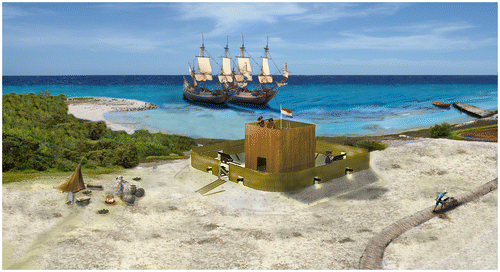
FIG. 15 Graphic reconstruction of the Dutch fort from 1638 on La Tortuga (drawing, Julijan Vermeer & Konrad A. Antczak).
If artefactual evidence of the Dutch presence at Punta Salinas is relatively limited, the material signature of other active groups is more limited still. Thus far, the archaeological record has been grudging with respect to evidence of the Spanish who are so visible in the documentary sources.Footnote142 We may expect that the majority of their militia were present only during armed clashes and the subsequent burning of Dutch facilities. The Spanish left further work on the saltpan to their Amerindian allies.Footnote143 Water and food supplies necessary for longer stays by the Spanish were almost certainly not included on these military expeditions because the seagoing piraguas from the mainland were already heavily loaded with people, armour, arms and munitions. It may be further hypothesized that most of the Spanish would have returned to the mainland almost immediately after accomplishing their missions, especially because of the likelihood they were taking their dead and wounded companions with them. Nevertheless, the sources narrate that at least in 1633, a few Spaniards did indeed spend several days on La Tortuga supervising the inundation of the saltpans by the Cumanagoto Indians.Footnote144 However, according to our current understanding of the site, a specific Spanish campsite was most probably never established. The few Spaniards may have slept either on land together with the Amerindians or aboard their canoes. The second option might have proved the more attractive for fear of attack by Dutchmen who had possibly escaped into the interior of the island, and for the purpose of staying as far away as possible from the unbearable mosquitoes. The archaeological evidence that could account for the presence of dozens of Amerindians at the site at different times, as referred to in the written sources, is currently weak and puzzling.Footnote145
Despite the challenges of the evidence, the archaeology at the Punta Salinas site is a palimpsest in which the individual events of a few years overlie the decades-long arc of Dutch mercantile projection into the world. This short time-frame invited us to engage with the scale of daily rhythms, rather than the large scale of distant impersonalized forces and processes operating beyond the perception of the local social actors. We found that this smaller scale meshed well with our own embodied experiences on La Tortuga, and also perceived this scale of events as closer to us, while the larger scale seemed more remote from the archaeological record at this site.Footnote146 In parallel, our Dutch agent-centred research enabled us to recover documentary and material traces of emotions, experiences and values that go beyond the mere sum of data extracted from the sources.Footnote147
There remain several challenges for future colonial period archaeological research on La Tortuga Island. In particular, we expect that we will be able to dispel some of the abovementioned uncertainties that currently surround the relative invisibility of the Amerindians in the archaeological record. Sound dating of relevant samples plus comparative analysis of the Amerindian materials recovered at this and other sites on the island, as well as on the adjacent mainland, may shed light on this issue. New evidence may also be provided by interdisciplinary research into Dutch, Spanish and Amerindian human remains that may be recovered at the site.
The Dutch, the Spanish and the Amerindians valued, used and categorized La Tortuga Island and its component parts in different ways. Each group brought to the island different wider identities, but at the same time different individual and sharedsubjectivities as well. The tragic deaths that occurred at the site were almost certainly perceived differently by the different social actors, even those who belonged to the same ‘faction’ that participated in the conflict. The aforementioned anonymous Dutch witness to the battle of 1638 expressed the emotional overburden of Dutch zoutvaerders’ participation in the risky business of salt exploitation through a poignant verse of his song,
So I will not sail anymore to fetch salt, For which you pay more than for gold, And which is difficult to acquire; Yes, indeed, in the end you have to pay for it With your flesh and blood.Footnote148
At least three different languages were spoken (and shouted) during the narrated events. They were employed to communicate realities to their users, mediate their interactions, and shape their inferences about and valuations of the island. Dutch, Spanish and Amerindians brought to the Punta Salinas landscape not only distinctive languages but also different ‘equipmental totalities’Footnote149 and ontologically distinctive enmeshments with human and other-than-human, animated and non-animated, material and immaterial entities. The invocation and the felt presence on the island of the spiritual entities, including the Christian God and saints, was most probably the order of the day.Footnote150 While these invocations indeed derived from a long-term structure, they functioned vitally in the moment for the individuals emotionally enmeshed in the specific life circumstances we have examined.
The Dutch perception of the environment sustained the strong nature-culture divide borne out in Western thought.Footnote151 The zoutvaerders, who were cognizant of the natural processes of salt formation on the saltpans of La Tortuga, took ‘control’ of them and even adopted the semi-industrial use of pumps, canals and floodgates. They modified the landscape in order to maximize salt output but retained a communal labour regime of task-oriented cooperation and mutual assistance. The risks were high in this business, yet the Dutch relentlessly put in practice their notions of what the solar salt exploitation process and its respective tasks and associated timeframes should entail. Even though the Spanish may have tried to deter further production through opening channels and flooding the pans, Dutch industriousness prevailed until the enterprise was finally cut off by Spanish military action.
It was around salt that the often conflicting interests of the Dutch, Amerindians and Spaniards circled and collided in the complex processes of forging colonial realities. However, the prose of life and death of those engaged with exploiting and defending La Tortuga was not merely subsumed by large-scale processes operating from beyond the Caribbean. The reconstruction of the lived experiences and emotions of the Dutch seafarers at Punta Salinas underscores their various entanglements with not only the global but also the local, constantly unfolding from one small-scale event to another.
ABBREVIATIONS
WIC Dutch West India Company
AHN Archivo Histórico Nacional
AGI Archivo General de Indias
SUMMARY IN FRENCH, GERMAN, ITALIAN AND SPANISH
RÉSUMÉ
Une affaire risquée : archéologie historique de l’entreprise hollandaise du sel sur l’île de la Tortuga, Venezuela (1624–38)
Dans les décennies des années 1620 et 1630, les Hollandais se sont engagés dans l’extraction du sel sur l’île de la Tortuga, au Venezuela, en érigeant un fort en bois, des emplacements de canons mobiles, des embarcadères et des équipements semi-industriels solaires de production de type de lac de sel. La pauvreté relative des enregistrements archéologiques juxtaposés avec la richesse des sources documentaires détaillées et des fouilles archéologiques ont menés à l’opérationnalisation de l’outil heuristique des paysages. Une construction critique de ces portions socialement vivantes des paysages insulaires ou marins montre 1) comment les conceptions au nord-ouest de l’Europe du contrôle culturel de la nature ont été intégrées dans l’organisation et l’ardeur au travail hollandais; 2) comment la stratégie d’optimisation des pratiques extractives et de minimalisation du risque a été justifiée dans l’éphémérité globale des structures, et 3) comment ces impératifs structurels ont été imbriqués dans la prose de la vie et de la mort humaines qui se déroulait à partir d’un événement à petit échelle à un autre sur cette île isolée.
ZUSAMMENFASSUNG
Riskantes Geschäft: Historische Archäologie eines holländischen Salz-Unternehmens auf der La Tortuga Insel, Venezuela (1624–38)
In den Dekaden der 1620er und 1630er Jahre beschäftigten sich Holländer mit Salzgewinnung auf der Insel La Tortuga, in Venezuela: sie errichteten ein hölzernes Ford, installierten Geschützstellungen, Anlegestellen und halb-industrielle Solar-Salzpfannen als Produktionsstätten. Der relative Mangel an archäologischen Unterlagen, im Gegensatz zum Reichtum der detaillierten Dokumentaren Daten und Feldarbeitserfahrungen, veranlaßte zum heuristischen Gebrauch von ‚-schaften‘: eine kritische Rekonstruktion dieser sozial lebendigen Teile der Insel- und Meer-Landschaften 1) wie nordwest-europäische Konzepte der kulturellen Kontrolle der Natur mit holländischer Ordnungsliebe und Tüchtigkeit verwachsen waren; 2) wie die Strategie der maximalen Extraktion bei minimalem Risiko sich in der allgemeinen Kurzlebigkeit der Strukturen zeigte; und 3) wie diese strukturellen Notwendigkeiten in der Prosa menschlichen Lebens und Sterbens sichtbar wurden von einem kleinen Vorkommen zum nächsten auf dieser desolaten Insel.
RIASSUNTO
Affari rischiosi: archeologia storica dell’impresa olandese del sale sull’isola de La Tortuga in Venezuela (1624–38)
Nei due decenni che separano il 1620 dal 1640, gli olandesi si impegnarono nell’estrazione del sale sull’isola de La Tortuga in Venezuela, costruendo un forte in legno, piattaforme per cannoni, banchine, e le strutture produttive di una salina marina semi-industriale a cielo aperto. La relativa esiguità delle testimonianze archeologiche, contrapposta alla ricchezza dei dettagliati dati documentari e delle esperienze di lavoro sul campo, ha portato alla ricostruzione euristica dei “paesaggi”.
Una ricostruzione critica di queste porzioni socialmente vitali di paesaggio terrestre e marittimo dell’isola dimostra: 1) in che modo le concezioni di controllo sulla natura, proprie dell’Europa nord-occidentale, fossero incarnate nella metodicità e nell’industriosità degli Olandesi; 2) come la strategia di massimizzazione delle pratiche estrattive e la minimizzazione del rischio emergano dalla natura complessivamente effimera delle strutture; 3) infine, come le necessità strutturali si sovrapponessero allo scorrere delle vicende umane, che si susseguivano su questa isola desolata, dipanandosi da un evento su piccola scala al successivo.
RESUMEN
Un negocio arriesgado: la arqueología histórica de la empresa holandesa de la sal en la Isla de La Tortuga, Venezuela (1624–38)
En las décadas de los años 1620 y 1630 los holandeses se dedicaron a la extracción de la sal en la isla de La Tortuga, Venezuela, levantando un fortín de madera, con emplazamientos de cañones portátiles, embarcaderos, y salinas semi-industriales. La relativa escasez de los restos junto con la riqueza de los datos documentales y un detallado trabajo de campo han conllevado la puesta en marcha de una herramienta heurística de varios ‘paisajes’. La construcción crítica de estas porciones socialmente vivas del paisaje de la isla y el paisaje marino permiten demostrar: 1) cómo se amalgamaron las concepciones europeas noroccidentales del control cultural de la naturaleza al orden y laboriosidad holandesas; 2) cómo se ha plasmado en dichas estructuras efímeras tanto la estrategia de explotar al máximo la extracción como el mantener al mínimo los riesgos que ello conllevaba; y 3) cómo los imperativos estructurales han quedado reflejados en la prosa de la vida humana y de la muerte que ocurrían de un suceso a otro en esta isla desierta.
The finds are deposited at the Unidad de Estudios Arqueológicos, Instituto de Estudios Regionales y Urbanos, Edif. MEU, piso 1, of. 124, Universidad Simón Bolívar, Sartenejas, Venezuela.
Andrzej Antczak, Leiden University, The Netherlands, and Universidad Simón Bolívar, Caracas, Venezuela [[email protected]; [email protected]]
Konrad A. Antczak, College of William & Mary, USA
Ma. Magdalena Antczak, Leiden University, The Netherlands, and Universidad Simón Bolívar, Caracas, Venezuela
ACKNOWLEDGEMENTS
The ideas expressed in this paper have greatly benefitted from the valuable comments of Daniel Bailey. We are grateful for the expertise and insights given by Arie Boomert, Don Duco, Jan van Oostveen, Menno Hoogland, Jimmy Mans, Alfonso Pleguezuelo Hernández, Emma Yanes, Geoff Egan, Bly Straube, Corinne Staal, Piet Boon, Yolia Tortolero and two anonymous reviewers. We are indebted to Michiel Bartels for his valuable observations and for drawing our attention to the Rhijnenburgh song. We thank Antonius Harmsen and Christopher Joby for their thoughtful assistance and expert translation of this song into English. Many thanks to Julijan Vermeer for his accurate modelling of the Dutch fort of 1638. Our acknowledgments go to Fundación Manoa, foremost to José Miguel Pérez Gómez and Karel Bentata, and to Fundación La Tortuga, especially to Alberto Boscari, José Voglar and Régulo Briceño. We owe our warmest thanks to Oliver Antczak, Reinaldo Suhr, Leonard Fehr, Ali Kohler, Rafael Strubiher, Carlos Rivero and Juan Salazar (Juancho) for their invaluable help during the fieldwork campaigns. We are also grateful to the Dutch, Polish and American Embassies in Caracas for their support in this research. Thanks to the Instituto de Estudios Regionales y Urbanos of the Universidad Simón Bolívar in Caracas for assistance on various important points. Finally, we acknowledge the Venezuelan Instituto del Patrimonio Cultural for the permissions given for our fieldwork. This research has received funding from European Research Council under the European Union’s Seventh Framework Programme (FP7/2007–13) ERC Grant agreement no. 319209, under the direction of Prof. Dr C. L. Hofman.
Notes
1 Antczak & Antczak 2006.
2 Antczak et al. 2011; Antczak 2015.
3 Van Ittersum 2007, 74. By 1596 Cumaná had approximately 180 Spanish colonists of both sexes and various ages (Castillo Hidalgo 2005, 357, 361, 383).
4 Castillo Hidalgo 2005, 476, table I; see also Goslinga 1971, 531, n. 63 and Sluiter 1948, 182.
5 The Dutch were perhaps encouraged by the experience of Portuguese merchant Tomé Rodriguez, who made mercantile trips to Cumaná in 1592 and 1594 (Castillo Hidalgo 2005, 480); see also Engel Sluiter (1948, 171–2) on the Dutch presence on the coast of Panama in 1572, in New Spain in 1594 and Brazil since 1587 (Sluiter 1942, 31; Israel 1990, 62).
6 Israel 1990, 56. According to Sluiter (1948, 168 and 170), there were three main seizures of foreign ships in Iberian Peninsula ports causing severe damage to Dutch merchantmen: in 1585 (100 Dutch ships seized in Lisbon and Setubál alone), 1595 (between 400 and 500) and 1598 (500).
7 Antunes 2008; Klooster 2003.
8 Prak 2009, 95; Harding 2013, 94, fig. 8.2.
9 Wallerstein 1980, 48. The ‘rich’ trade consisted of goods small in size and weight (e.g. spices) in proportion to their value; expensive and armed merchantmen were advantageous here. Salt and timber were the ‘bulk’ trade products where speed and efficiency were advantageous, armed convoys being unnecessary at least in the initial phases (e.g. Araya salt); for comparisons between diverse European salt sources of that time consult Hughes (1925, 338–40, 345), Unger (1980, 256), Israel (1990, 6, 7), Braudel (1992, 137–8, 208, 257), Herrero Sánchez (1993, 178), and Emmer (2003).
10 Bartels 2009.
11 Hulsman 2009, 54; Israel 1990, 63.
12 Ricardo Ignacio Castillo Hidalgo (2005, 491, table III) gives estimates; in 1599 between 15 and 17 Dutch fluits loaded salt in Araya while four or five English ships were dedicated to contraband (Castillo Hidalgo 2005, 488–9). According to Sluiter (1948, 177–8), from 7 June 1600 to 8 December 1605 a minimum of 611 Dutch salt ships and 55 smuggling vessels came to the Margarita-Araya-Cumaná area.
13 Vila 1980, 174; Varela Marcos 1980, 88–126.
14 Varela Marcos 1980, 202–10. The cruelty of the Spanish was emphatically described by Velius 1740 in Goslinga 1971, 123–4.
15 Sluiter 1942, 35; see also Antunes 2008, graph 2.
16 Van Hoboken 1960.
17 Boxer 1977, 25; Schmidt 2001, 194; Schnurmann 2003, 479–81; see also de Vries & Woude 1997, 399; Goslinga 1971, 87, 94, 100, 125.
18 Israel 2002, 138.
19 Felice Cardot 1982, 113–14.
20 Vázquez de Espinosa 1987 [1629], 74.
21 Felice Cardot 1982, 115–17; Goslinga 1971, 127–8.
22 Israel 2002, 138, citing Velius 1740; Felice Cardot 1982, 118; Goslinga 1971, 128. These enterprises by corporate groups of ‘small merchants’ from West Friesland are mentioned in Goslinga 1971, 126; see also Emmer 1998, 72; Wallerstein 1980, 56.
23 Israel 1977, 53.
24 Goslinga 1971, 129.
25 Rogoziski 2000, 65–6.
26 Goslinga 1971, 129.
27 Letter of Diego Acuña to the Crown, Santo Domingo, 13 February 1625, in Wright & Van Dam 1934, 203.
28 Meerhout 1625 [9 June].
29 From Antonelli’s letter to the King dated 20 November 1633 in Cumaná (Wright & Van Dam 1934, 136–40, Doc. 39), it is clear that his report from 1626 was accompanied by a sketch of the saltpan, rendered in colour, that is currently lost.
30 Jeannin 1968, 81, in Herrero Sánchez 1993, 192. By late 1620s the Dutchmen were very active off the Venezuelan coast. In 1628 alone, three important figures arrived at Bonaire: Johannes de Laet on behalf of the West Indies Company, Commander Boudewijn Hendricks, and the Rear-Admiral Piet Heyn (Haviser 1991, 176).
31 Goslinga 1971, 129; see also Van Deursen 1991, 46.
32 Documentary sources attest to the interconnections between the Dutch sailors who were targeting the La Tortuga and Unare saltpans, and the outposts at Curaçao, Saint Martin, and others (Wright & Van Dam 1934, 139, 146, 148).
33 Wright & Van Dam 1934, 161–78.
34 Rogoziński 2000, 65–6; Felice Cardot 1982, 193–6.
35 Felice Cardot 1982, 193.
36 Rogoziński 2000, 66; Goslinga 1971, 136.
37 Vila 1975, 341–5.
38 Hamilakis 2011, 208–11; Harris & Sørensen 2010, 189.
39 According to Fernand Braudel (1980, 28), the ‘mediocre accidents of ordinary life […] are proportionate to individuals, to daily life, to our illusions, to our hasty awareness’ and their short time span ‘plays a part in all forms of life’.
40 Ingold 1993, 162. Words in single quotation marks indicate Ingold’s citations from Mead 1977 [1938].
41 Ingold 1993, 162.
42 Ingold 2000, 195.
43 Ingold 1993, 158.
44 Ingold 2000, 332–3.
45 de Laet 1988 [1644], 1224–5.
46 de Vries 1857 [1655], 70.
47 de Laet 1988 [1644], 1239.
48 Wright & Van Dam 1934, Doc. 40, 141.
49 José Miguel Pérez Gómez, Jorge García, pers. comm. 2013.
50 Wright & Van Dam 1934, Doc. 35, 128.
51 Letter of Francisco Núñez Meleán, Gobernador y Capitán General de la Provincia de Venezuela, to the King, August 22, 1630, Caracas, in Wright & Van Dam 1934, Doc. 35, 124. At Araya in 1603 all Dutch zoutvaerders were involved in saltworks on land with the exception of the captain, master, pilot, steward, cook and pages who were left on the fluits (Valera Marcos 1980, 269).
52 One of the fluits was renamed Galeón Santa Cruz and served in a Real Armada that guarded the Spanish Indies (AHN, Diversos-Colecciones, 26, N.81, 2).
53 1632, 12 October, Madrid, Benito Arias Montano to the King in Wright & Van Dam 1934, Doc. 36, 129–32. In the instruction dated 3 August 1631, at La Guaira, the Governor and General Captain of the Province of Venezuela Francisco Núñez Meleán ordered Captain Pedro de Llovera to take eighteen mariners and Spanish soldiers and 24 Indian oarsmen and archers in one boat and two piraguas and sail to La Tortuga to catch the Dutch who had escaped during Montano’s attack. They were also instructed to collect ropes and anchors which were apparently cut off as the Dutch attempted escape and to destroy all Dutch facilities on the saltpans. Dutch prisoners were brought to Caracas and some of them were baptized as Catholics (Dupouy 1945, 15–17).
54 Three Dutch patrolling boats on La Tortuga are mentioned in a letter of Benito Arias Montano to Ruy Fernández de Fuenmayor of 10 June 1638, Cumaná (Wright & Van Dam 1934, Doc. 40, 140–1).
55 Ingold 1993, 163.
56 According to Seledón de Suasola, the Spanish castaway who sought help from Dutch zoutvaerders on La Tortuga, the wreck occurred on 1 June 1630 and until 16 August of that year he and his companions lived on Dutch fluits anchored in Punta Salinas Bay of La Tortuga (declaration of castaway Seledón de Suasola written on 17 August 1630 [Wright & Van Dam 1934, Doc. 35, 125–9]).
57 Letter from Núñez Meleán to the King containing the declaration of Jacinto Rodríguez de Amaya, 5 October 1632, Caracas (Wright & Van Dam 1934, Doc. 37, 134–5). This information is confirmed by two other documents: a report by Bautista Antonelli, 20 November 1633, Cumaná, in Wright & Van Dam 1934, Doc. 39, 136–40, and in a letter from Alonso Hernández de la Rosa to Núñez Meleán, 22 October 1632, Cumaná, in Wright & Van Dam 1934, Doc. 38, 136.
58 Letter of Núñez Meleán to the King containing the declaration of Jacinto Rodríguez de Amaya, 5 October 1632, Caracas (Wright & Van Dam 1934, Doc. 37, 134–5). The jetty and the ‘platform’ are also mentioned in a letter from Alonso Hernández de la Rosa to Núñez Meleán, 22 October 1632, Cumaná (Wright & Van Dam 1934, Doc. 38, 136).
59 Wright & Van Dam 1934, Doc. 36, 129–32; Doc. 38, 136; Doc. 40, 140–1.
60 The document that relates the victory of Arias Montano over the Dutch at Unare in 1633 and printed in Seville in 1634 states that there were 14 fluits on La Tortuga during Montano’s and Antonelli’s attack.
61 Wright & Van Dam 1934, Doc. 35, 125–9. Antonelli mentions that 32 fluits loaded salt between August and September of 1633, adding that during the entire year some 150 fluits or more could load salt on La Tortuga. We consider the latter number to be highly exaggerated.
62 Captain David de Vries approached La Tortuga on 16 May 1632 but ‘did not venture to stop there for salt, because we were alone’ (de Vries 1857 [1655], 70).
63 Wright & Van Dam 1934, Doc. 35, 125–9.
64 Wright & Van Dam 1934, Doc. 35, 125–9.
65 Rhijnenburgh 1661, 5–12. This song was to be sung to the tune of ‘Adieu Malacca, we depart from here’. The song opens the second edition of the book of songs; the first edition, published most probably closer to 1638, is unknown.
66 Between February and June is the lowest mean monthly precipitation (12.22 mm) on La Orchila Island, north-west of La Tortuga (Ministerio de la Defensa 1988). The beginning of the dry season coincided with the last months of wintering by the Spanish Flota de las Indias, a circumstance providing the Dutch the greatest security for operations in the Caribbean. See also Pethick 1997, 163; Viles & Spencer 1995, 187–8.
67 Wright & Van Dam 1934, Doc. 39, 136–40.
68 Declaration of castaway Seledón de Suasola, 20 August 1630, Caracas in Wright & Van Dam 1934, 127–8.
69 Varela Marcos 1980, 77.
70 Varela Marcos 1980, 77.
71 Declaration of castaway Seledón de Suasola, 20 August 1630, Caracas in Wright & Van Dam 1934, 128.
72 Varela Marcos 1980, 76.
73 The flagship and three other ships came from an unspecified town nearly 10km distant from Amsterdam; the ship of the number-two-ranking officer in the fleet and two others came from the town of Medemblik or Middleburg. Suasola obtained the information from the pilot of the Admiral ship; the town of Nostradama in the Spanish original was read as Amsterdam and Minbre as Medemblik.
74 Wright & Van Dam 1934, Doc. 36, 131.
75 Letter from Francisco Núñez Meleán, Governor and Captain of the Province of Caracas to the King, 5 October 1632, Caracas in Wright & Van Dam 1934, Doc. 37, 133–4.
76 Declaration of Jacinto de Amaya, 1 October 1632, Caracas, in Wright & Van Dam 1934, 134–5. Jacinto de Amaya proved to be an exemplary soldier of the King, in 1635 undertaking a risky reconnaissance of the new Dutch post in Curaçao (Felice Cardot 1982, 23).
77 A letter of Alonso Hernández de la Rosa to Francisco Núñez Meleán dated 22 October 1632, in Cumaná refers to fourteen pumps observed on La Tortuga, adding that two were brought to Cumaná together with some pine planks after all the rest were burnt and dismantled (Wright & Van Dam 1934, Doc. 38, 136).
78 Report of Juan Bautista Antonelli, 20 November 1633, Cumaná, in Wright & Van Dam 1934, Doc. 39, 137.
79 Wright & Van Dam 1934, Doc. 39, 137; Antonelli extrapolated the total salt production data from the amount obtained from one era.
80 In two letters written to the King on August 2 from Cumaná (before participating in Arias Montano’s defeat of the Dutch at the saltpan of Unare towards the end of August) and on 15 September 1633 (while waiting for the trip to La Tortuga with Arias Montano), Antonelli revealed his firm intention to flood the La Tortuga saltpans (Gasparini 2007, 234–5).
81 Wright & Van Dam 1934, Doc. 39, 137.
82 After the skirmish in 1633 and until 1638, Arias Montano was sending spies to La Tortuga every four months. Still in March of 1639 a few Dutch fluits approached La Tortuga, but frightened by Montano’s envoy, sailed towards Cartagena (AHN, Diversos-Colecciones, 26, N.81).
83 This canal is not depicted on the map printed in 1639 in Seville (AHN, Diversos-Colecciones, 26, N.81).
84 AHN, Diversos-Colecciones, 26, N.81.
85 Two documents related to the claims of the Títulos de Encomiendas of the descendants of the Spanish that participated in Montano’s 1638 action state that, on that occasion, the saltpans were flooded by opening a channel to the sea (Da Prato-Perelli 1990, vol. 4, 177, 311).
86 Don Sancho Zapata de Mendoza spent 28 days on La Tortuga and personally financed the infantrymen; however, whether this occurred in 1633 or in 1638 is not clear (Da Prato-Perelli 1990, vol. 1, 329).
87 Antonelli reports that the La Tortuga saltpan had been ‘flooded and razed to the ground by the Cumanagoto Indians’ (Wright & Van Dam 1934, Doc. 39, 139), indicating that this hard labour was performed by the Cumanagoto Indians while the majority of the Spanish who participated in these military actions probably returned home immediately after the action. One reason for this was that provisions had been allotted for days, not weeks. As an example, Antonelli (the Younger) spent only two days on La Tortuga in 1633, despite the large project that he had devised and, supposedly, had to supervise.
88 Schama 1997, 375.
89 Whitehead 1990.
90 Wright & Van Dam 1934, 130. Arias Montano financed both actions himself, donated one of the ships to the Armada and asked the King for the governorship of Caracas. He was granted the governorship of Nueva Andalucía instead, assuming it in 1633.
91 The largest dugout canoe held 24 persons with paddles (Wright & Van Dam 1934, 130).
92 Marley 1998, 118.
93 Wright & Van Dam 1934, 133. Another testimony mentions the emplacement for ‘gun ports’ for two or three cannons (Wright & Van Dam 1934, 135).
94 Letter from Don Juan de Eulate, Governor of Margarita to the King of Spain dated 20 July 1633, in which he describes the reconnaissance undertaken on La Tortuga on his orders (The Trinidad Historical Society, 1633).
95 Felice Cardot 1982, 194.
96 Felice Cardot 1982, 166–7.
97 Hamelberg 1901, 18–19 in Felice Cardot 1982, 204.
98 By the mid 1630s, the Spanish informants were repeatedly reporting that despite the efforts made by the Dutch, salt production on Curaçao was meagre (Wright & Van Dam 1934, 204, 219, 225, 229, 236–7).
99 Wright & Van Dam 1934, 140–1.
100 The data drawn from Spanish sources is confirmed by the Dutch song (Rhijnenburgh 1661). The author of the song was apparently on board of the Dutch ship King Daniel captained by Iacob Tomesz de Jongge from Medemblik which, accompanied by three boats, was fetching water at the westernmost point of La Tortuga (see ). This vessel was considered a lookout ship by the Spanish (Rhijnenburgh 1661, 7–8).
101 See Rhijnenburgh (1661, 12–13) for further details on the account of the anonymous author of the above song, which offers further details on Amerindian participation in the attack and the Dutch surrender.
102 Wright & Van Dam 1934, 141 (report by Benito Arias Montano dated 10 June 1638, in Cumaná). A similar stockade with poles topped by iron barbs curving outwards was also seen at the Dutch fortifications on Curaçao, according to Spanish documents from 1635 and 1636 (Wright & Van Dam 1934, 203, 232).
103 According to Spanish sources, in 1636 two Dutch fortifications on Curaçao had some 460 men, of whom 25 were sailors and the remaining soldiers (300 veterans and the remaining greenhorns), mainly English, French, Scottish, Walloons, Zealanders, Germans (Wright & Van Dam 1934, 233), and Scandinavians (Enthoven 2005, 162).
104 Benito Arias Montano to Ruy Fernández de Fuenmayor, Cumaná, 10 June, 1638 in Wright & Van Dam 1934, 140, 141; AGI, MP-Venezuela, 24 – Planta de la Isla Tortuga.
105 In 1997 and 1999 the members of the Amsterdam Archaeological Centre, University of Amsterdam, carried out a survey along the coast of Venezuela with the objective ‘to find traces of the salt-gathering activities of Dutch sailors’ (Van Beek, 2002, 84). On La Tortuga, the team visited the small bay of Carenero to the west of the Punta Salinas archaeological site (see also Van Beek et al. 1999).
106 AHN, Diversos-Colecciones, 26, N.81.
107 These actions are depicted in the images from the time () and vividly rendered in words in the Rhijnenburgh song (1661).
108 Three shovel test pits were excavated in this structure in 1992 but were sterile.
109 Haviser 2010, 172.
110 For a similar conclusion related to the moat at Fort de Goede Hoop from 1652 in Cape Town, South Africa, see Abrahams 1993, 13.
111 Deagan 1987, 74, 109, pl. 3, E; Emma Yanes pers. comm. 2012.
112 Klijn 1995, 217, fig. 4.b. 143; Allan & Barber 1992, 232, 236, fig. 3, 21.
113 Schaefer 1994, fig. 15 (1 & 7), 382–3.
114 Hurst et al. 1986, 134–6.
115 Scholten 1993, 26–7, fig. 24; Korf 1981, 27, fig. 14.
116 Korf 1981, 32–3, fig. 29.
117 Van den Bossche 2001, 308, 167.
118 The numbers of stems and bowls recovered in the earthwork and specified here include those recovered from the feature in the central part of the earthwork and described at the beginning of this section.
119 Don Duco pers. comm. 2010; Jan van Oostveen pers. comm. 2010.
120 Jan van Oostveen pers. comm. 2010; Duco 1987, fig. 466.
121 One partial carcass of a rabbit was found by the authors lying on the ground surface a few kilometres west of the Punta Salinas site; fishermen confirm sightings of rabbits on the island.
122 For early presence of rabbits in the Netherlands see Lauwerier & Zeiler (2001, 89) and Van Dam (2001, 167). Rabbits were often carried on board ships at sea and placed on islands to provide food for the shipwrecked; alternatively, the wrecking of a ship could cast the rabbits onto an island where they had not previously been present (Armstrong 1982, 354–5). Rabbit remains were also numerous on site at the Royal Navy Victualing Yard in London during the second part of 16th and 17th centuries (West 1995).
123 Rabbits were introduced on La Tortuga in pre-Dutch times. In 1578, the Governor of the Province of Venezuela, don Juan de Pimentel, while describing the islands off the coast of Venezuela including La Tortuga, said that ‘in one or two of [the islands] there is a lot of salt, [many] rabbits, and an abundance of fish in all of them &…’ (Pimentel 1578 in Nectario María 1979, 331–51). La Tortuga, with an area of nearly six hectares, is within the lower range of island areas that are capable of supporting permanent rabbit populations (Armstrong 1982, 360).
124 The butchery of game on fluits avoided the problem of sand and flies that were ubiquitous on land, especially in the saltpan area.
125 During the fieldwork, members of the archaeological team fished with hook-and-line and caught all of the stated types of fish with the exception of Carangidae.
126 Sea turtles were abundantly eaten by the permanent occupants of the Dutch Fort Amsterdam on Saint Martin (Dutch Sint Maarten), Netherlands Antilles, who also ate cattle, pigs and goats (Baart et al. 1988, 274–5). Menkman (1935, 195) mentions that the Dutch on La Tortuga hunted goats and turtles. The unexpected absence of turtle bones in Dutch-related deposits on Punta Salinas site may be attributable to the temporary character of the land installations, butchery on board, or differentiated consumption and discard.
127 It is possible that many local marine animals unfamiliar to the Dutch sailors might have been considered venomous or ‘unhealthy’, judging from mid 16th-century observations made by the Italian merchant Galeotto Cey in Santo Domingo and Venezuela (Cey 1995, 30, 32). However, accounts from 1626 mention the use of fishing nets by the Dutch sailors in Mochima on the north-eastern coast of Venezuela (Wright & Van Dam 1934, 62).
128 Analyzing the 1661 song (Rhijnenburgh 1661, 13) it seems likely that captains of ships at anchor in the bay took night shifts in the fort accompanied by their crew members (cannon operators and surgeons), while permanent mercenary musketeers might have been the minority of the fort garrison if they were present at all. If so, the food consumed in or around the fort during the watch would have been prepared on the watchkeepers’ respective ships.
129 See Floore & Jayasena 2010, 336 for similar conclusions. This attitude might have corresponded to the counteractive model expected among the 17th-century Dutchmen, according to which the human bodily complexion was formed ‘in opposition or through resistance to the environment’ and, especially, if the environment was new and unknown (Floyd-Wilson & Sullivan 2007, 5). Reports from Curaçao indicate that by the end of the 1630s fluits were bringing almost all necessary food from Holland; these victuals were paid for by the WIC (Wright & Van Dam 1634, 226, 227, 236).
130 Wright & Van Dam 1934, 121.
131 Wright & Van Dam 1934, 166–7.
132 The first was recovered in systematic archaeological excavation, while the second was found by a metal detectorist who allowed the authors to examine it and precisely described the site and depth of its discovery. No other cannonballs were recovered, although an amateur explorer reportedly found one of unknown size at the Punta Salinas site in the 1970s.
133 These measurements are roughly confirmed by the Dutch witness to the 1638 battle who stated that Dutch fort defenders were shooting 5- to 6-pound cannonballs (Rhijnenburgh 1661, 9).
134 Manucy 1955, 6, 18–20.
135 The 1638 Dutch-Spanish/Amerindian battle is the only one referenced in the documentary sources in which Dutch cannons were fired from the anchored fluits towards the enemies that attacked the fort on the seashore.
136 A Dutch source confirms that the Spanish and Amerindians came ‘from the woods’, meaning from the mangrove thickets to the southeast of the fort (Rhijnenburgh 1661, 8).
137 Wright & Van Dam 1934, 127.
138 Jayasena 2006, 119–22.
139 Similar parameters have been applied at other contemporary Dutch forts (see Jayasena 2006, 112; Floore & Jayasena 2010, 322; Haviser 2010).
140 Drawing from their dreadful experience on La Tortuga during the decade of the 1630s, the Dutch zoutvaerders could not contribute positively to the appearance of the Noble Savage allegory in the Old World. In some other Dutch outposts in the region where the Amerindians were no longer a direct threat to their colonial interests, these people could indeed be depicted in benevolent terms (see Oostindie & Paasman 1998, 353).
141 Robb & Pauketat 2013.
142 Unless the brimmed dish of probable San Juan polychrome Mexican majolica may be considered a remnant of the Spanish presence at the site. This find was included in the Dutch assemblage due to its depositional characteristics.
143 Spanish military engineer Antonelli (the Younger) spent only two days on La Tortuga in 1633; but we may deduce that he had to stay longer as, supposedly, he had to supervise the works on the inundation of the saltpan which he himself had designed.
144 We suspect that the number of Spaniards involved in the labour was lower than the 50 individuals reported by Antonelli. Note also that the saltpan at Unare, on the mainland coast of Venezuela, was also inundated to prevent its exploitation by the Dutch, and eight Spaniards and 50–60 Amerindians were involved in that effort (Wright & Van Dam 1934, 158).
145 Stevanato et al. 2012.
146 Hodder 2000, 30.
147 Brumfiel 2000, 252.
148 Rhijnenburgh 1661, 13.
149 See George 2000, 80–5 for a succinct explanation of Martin Heidegger’s ‘equipmental totality’ concept.
150 While the spiritual reference points of the Dutch and Spanish were with different Christian denominations, the Amerindians (including any converts) were almost certainly still largely imbued with an ontologically different perspectival participation in the life of the surrounding world (see Viveiros de Castro 1998; Descola 2013).
151 Glacken 1976.
Related Research Data
Bibliography
- Abrahams, G. 1993, ‘The Grand Parade, Cape Town: archaeological excavations of the seventeenth-century Fort de Goede Hoop’, S. African Archaeol. Bull. 48, 3–15.
- Allan, J. & Barber, J. 1992, ‘A seventeenth-century pottery group from Kitto Institute, Plymouth’, in Gaimster & Redknap 1992, 225–45.
- Antczak, K.A. 2015, ‘“Tavern” by the saltpan: New England seafarers and the politics of punch on La Tortuga Island, Venezuela, 1682–1781’, Int. J. Hist. Archaeol. 19:1, 159–87.
- Antczak, K.A., Antczak, A., Antczak, Ma. M. & Pérez Gómez, J.M. 2011, ‘Historical archaeology of the 18th-century Atlantic connections of La Tortuga Island, Venezuela’, Fort-de-France, Martinique: Paper presented at the 24th Congress of the International Association for Caribbean Archaeology.
- Antczak, Ma. M. & Antczak, A. 2006, Losídolos de las Islas Prometidas: arqueología prehispánica del Archipiélago de Los Roques, Caracas: Editorial Equinoccio.
- Antunes, C. 2008, ‘The commercial relationship between Amsterdam and the Portuguese salt-exporting ports: Aveiro and Setúbal, 1580–1715’, J. Early Mod. Hist. 12:1, 25–53.
- Archivo General de Indias, AGI 1638, MP-Venezuela, 24 – Planta de la Isla Tortuga, Ministerio de Educación, Cultura y Deporte, España.
- Archivo Histórico Nacional, AHN 1639, Diversos-Colecciones, 26, N.81., Ministerio de Educación, Cultura y Deporte, España.
- Armstrong, P. 1982, ‘Rabbits (Oryctolkgus cuniculus) on islands: a case-study of successful colonization’, J. Biogeogr. 9, 353–62.
- Baart, J.M., Krook, W. & Lagerweij, A.C. 1988, ‘Fort Amsterdam. Archeologisch onderzoek op Sint Maarten, Nederlandse Antillen’, Bull. KNOB 6, 270–6.
- Bartels, M. 2009, ‘Hoorn and Enkhuizen, West Frisia’, in Wright & Ottaway, 73–90.
- Bartels, M., Cordfunke, E.H.P. and Sarfatij, H. (eds) 2002, Hollanders uit en thuis. Archeologie, geschiedenis en bouwhistorie gedurende de VOC-tijd de Oost, de West en thuis. Cultuurhistorie van de Nederlandse expansie, Hilversum: Uitgeverij Verloren.
- Becco, H.J. (compiler) 1987, Venezuela Imágenes de Cuatro Siglos: Testimonios de Viajeros, Caracas: Fundación de Promoción Cultural de Venezuela.
- Boxer, C.R. 1977, The Dutch Seaborne Empire, 1600–1800, London: Hutchinson.
- Braudel, F. 1980, On History, Chicago: University Press.
- Braudel, F. 1992, Civilization and Capitalism, 15th–18th Century: The Structures of Everyday Life, Berkeley: University of California Press.
- Brumfiel, E.M. 2000, ‘On the archaeology of choice: agency studies as a research stratagem’, in Dobres & Robb 2000, 249–55.
- Castillo Hidalgo, R.I. 2005, Asentamiento español y articulación interétnica en Cumaná (1560–1620), Biblioteca de la Academia Nacional de la Historia 259, Caracas: Academia Nacional de la Historia.
- Cey, G. 1995, Viaje y descripción de las Indias 1539–1553, Caracas: Fundación Banco Venezolano de Crédito.
- Da Prato-Perelli, A. 1990, Las encomiendas de Nueva Andalucía en el siglo XVIII: visita hecha por don Fernando de la Riva Agüero, oidor de la Audiencia de Santo Domingo 1688, Caracas: Biblioteca de la Academia Nacional de La Historia.
- Deagan, K. 1987, Artifacts of the Spanish Colonies of Florida and the Caribbean, 1500–1800, Washington: Smithsonian Institution Press.
- Descola, P. 2013, Beyond Nature and Culture, Chicago: University Press.
- de Vries, D.P. 1857 [1655], Voyages from Holland to America, A. D., 1632 to 1644, Collections of the New York Historical Society, 2nd ser., vol. 3, part 1, 9–137, New York: D. Appleton.
- de Vries, J. & Van der Woude, A. 1997, The First Modern Economy: Success, Failure, and Perseverance of the Dutch Economy, 1500–1815, Cambridge: University Press.
- Dobres, M.-A. & Robb, J. (eds) 2000, Agency in Archaeology, New York: Routledge.
- Duco, D.H. 1987, De Nederlandse Kleipijp: Handboek Voor Dateren en Determineren, Leiden: Stichting Pijpenkabinet.
- Dupouy, W. 1945, ‘Datos para la historia de la Isla de la Tortuga, Venezuela’, Separata de la Memoria de la Sociedad de Ciencias Naturales La Salle 5:13, 3–19.
- Emmer, P.C. 2003, ‘The first global war: The Dutch versus Iberia in Asia, Africa and the New World 1590–1609’, E-Journal Portuguese Hist. 1:1.
- Emmer, P.C. 1998, The Dutch in the Atlantic Economy, 1580–1880: Trade, Slavery and Emancipation, Brookfield (Vt.): Ashgate.
- Enthoven, V. 2005, ‘Dutch crossings: migration between the Netherlands and the New World, 1600/1800’, Atl. Stud. 2:2, 153–76.
- Felice Cardot, F. 1982, Curazao hispánico: antagonismo flamenco-español, Caracas: Ediciones de la Presidencia de la República.
- Floore, P.M. & Jayasena, R.M. 2010, ‘In want of everything? Archaeological perceptions of a Dutch outstation on Mauritius (1638–1710)’, Post-Medieval Archaeol.44:2, 320–40.
- Floyd-Wilson, M. & Sullivan, G.A. 2007, ‘Introduction: inhabiting the body, inhabiting the world, in environment and embodiment’, in Floyd-Wilson & Sullivan 2007, 1–13.
- Floyd-Wilson, M. & Sullivan, G.A. 2007, Early Modern England, New York: Palgrave MacMillan.
- Gaimster, D. & Redknap, M. (eds) 1992, Everyday and Exotic Pottery from Europe c. 650–1900: Studies in Honour of John G. Hurst, Oxford: Oxbow Books.
- Gasparini, G. 2007, Los Antonelli: arquitectos militares italianos al servicio de la Corona española en España,África y América, 1559–1649, Caracas: Editorial Arte.
- George, V.A. 2000, The Experience of Being as Goal of Human Existence: The Heideggerian Approach, Washington: The Council for Research in Values and Philosophy.
- Glacken, C.J. 1976, Traces on the Rhodian Shore: Nature and Culture in Western Thought from Ancient Times to the End of the Eighteenth Century, Oakland: University of California Press.
- Goslinga, C.Ch. 1971, The Dutch in the Caribbean and on the Wild Coast, Gainesville: University of Florida Press.
- Hamelberg, J.H. 1901, Documenten behoorende bij De Nederlanders op. De West-Indische Eilanden. I, Curaçao, Bonaire, Aruba. Bijeen Verzameld, Amsterdam: Gedrukt en Uitgeven Bij. J.H. de Bussy.
- Hamilakis, Y. 2011, ‘Archaeologies of the Senses’, in Insoll 2011, 208–25.
- Harding, A. 2013, Salt in Prehistoric Europe, Leiden: Sidestone Press.
- Harris, J.T. & Sørensen, T.F. 2010, ‘Rethinking emotion and material culture’, Archaeol. Dialogues 17:2, 145–63.
- Haviser, J.B. 1991, The First Bonaireans, Curaçao: Archaeological-Anthropological Institute of the Netherlands Antilles.
- Haviser, J.B. 2010, ‘The “Old Netherlands Style” and seventeenth-century Dutch fortifications of the Caribbean’, in Klingelhofer 2010, 167–87.
- Herrero Sánchez, M. 1993, ‘La explotación de las salinas de Punta de Araya. Un factor conflictivo en el proceso de acercamiento hispano-neerlandés (1648–1677)’, Cuadernos de Historia Moderna 14, 173–94.
- Hodder, I. 2000, ‘Agency and individuals in long-term processes’, in Dobres & Robb 2000, 21–33.
- Hughes, E. 1925, ‘The English monopoly of salt in the years 1563–71’, Engl. Hist. Rev. 40:159, 334–50.
- Hulsman, L.A.H.C. 2009, ‘Nederlands Amazonia: Handel met Indianen Tussen 1580 en 1680’, University of Amsterdam doctoral thesis.
- Hurst, J.G., Neal, D.S. & Van Beuningen, H.J.E. 1986, Pottery Produced and Traded in North-West Europe 1350–1650, Rotterdam Papers VI, Rotterdam: Museum Boymans-van Beuningen.
- Ingold, T. 1993, ‘The temporality of the landscape’, World Archaeol.25:2, 152–74.
- Ingold, T. 2000, The Perception of the Environment: Essays on Livelihood, Dwelling and Skill, New York: Routledge.
- Insoll, T. (ed.) 2011, The Oxford Handbook of the Archaeology of Ritual and Religion, Oxford: University Press.
- Israel, J.I. 1977, ‘A conflict of empires: Spain and Netherlands 1618–1648’, Past and Present 76, 34–74.
- Israel, J.I. 1990, Dutch Primacy in World Trade 1585–1740, Oxford: Clarendon Press.
- Israel, J.I. 2002, Diasporas within a Diaspora: Jews, Crypto-Jews, and the World of Maritime Empires 1540–1740, Leiden: Brill.
- Jayasena, R.M. 2006, ‘The historical archaeology of Katuwana, a Dutch East India Company fort in Sri Lanka’, Post-Medieval Archaeol. 40:1, 111–28.
- Jeannin, P. 1968, ‘Le marche du sel marin dans l’Europe du nord du XIV au XVIII siècle’, in Mollat 1968, 73–93.
- Klijn, E.M.Ch.F. 1995, Lead-Glazed Earthenware in the Netherlands: the Collection of the Netherlands Openluchtmuseum, Arnhem: Netherlands Openluchtmuseum.
- Klingelhofer, E. (ed.) 2010, First Forts: Essays on the Archaeology of Proto-colonial Fortifications, Leiden: Brill.
- Klooster, W. 2003, ‘An overview of Dutch trade with the Americas, 1600–1800’, in Postma & Enthoven 2003, 365–83.
- Korf, D. 1981, Nederlandse Majolica, Haarlem: De Haan.
- Lauwerier, R.C.G.M. & Zeiler, J.T. 2001, ‘Wishful thinking and the introduction of the rabbit to the Low Countries’, Envir. Archaeol. 6, 87–90.
- Manucy, A. 1955, Artillery through the Ages: A Short Illustrated History of Cannon, Emphasizing the Types Used in America, Interpretive Series History No. 3. Washington: US Government Printing Office.
- Marley, D.F. 1998, Wars of the Americas: A Chronology of Armed Conflict in the New World, 1492 to the Present, Santa Barbara: ABC-CLIO.
- Mead, G.H. 1977 [1938], ‘The process of mind in nature’, in Strauss 1977, 85–111.
- Meerhout, J. 1625 [June 9], Not. Arch. 256/f. 189, Amsterdam: Notarial Archives, Amsterdam City Archives.
- Menkman, W.R. 1935, ‘Twee belangrijke uitgaven’, West-Indische Gids 17, 193–212.
- Ministerio de la Defensa 1988, Boletín Climatológico Anual 1987, Caracas: Comandancia General de la Armada, Observatorio Cagigal, Departamento de Meteorología.
- Mollat, M. (ed.) 1968, Le Role du sel dans l’historie, Paris: Presses Universitaires de France.
- Nectario María, Hno. 1979, Historia de la conquista y fundación de Caracas, Caracas: Gráficas La Bodoniana.
- Oostindie, G. & Paasman, B. 1998, ‘Dutch attitudes towards colonial empires, indigenous cultures, and slaves’, Eighteenth-Century Stud. 31:3, 349–55.
- Pethick, J. 1997, An Introduction to Coastal Geomorphology, New York: Wiley-Blackwell.
- Postma, J. & Enthoven, V. (eds) 2003, Riches From Atlantic Commerce: Dutch Transatlantic Trade and Shipping, 1585–1817, Leiden: Brill.
- Prak, M. 2009, The Dutch Republic in the Seventeenth Century: The Golden Age, Cambridge: University Press.
- Rhijnenburgh, C. 1661, Vreugde-bergh, het tweede deel. Bestaende in nieu-jaers en kars-gesanggen, ziel-suchten, en andere opmerckende deuntjes, 2nd edn, Claesz Theunisz: Medemblik.
- Robb, J. & Pauketat, T.R. 2013, ‘From moments to millenia: theorizing scale and change in human history’, in Robb & Pauketat 2013, 3–34.
- Robb, J. & Pauketat, T.R. (eds) 2013, Big Histories, Human Lives: Tackling Problems of Scale in Archaeology, Santa Fe: School for Advanced Research Press.
- Rogoziński, J.A 2000, A Brief History of the Caribbean: From the Arawak and Carib to the Present, New York: A Plume Book.
- Schaefer, R.G. 1994, ‘A Typology of Seventeenth-Century Dutch Ceramics and its Implications for American Historical Archaeology’, University of Pennsylvania doctoral thesis.
- Schama, S. 1997, The Embarrassment of Riches: An Interpretation of Dutch Culture in the Golden Age, New York: Vintage Books.
- Schmidt, B. 2001, Innocence Abroad: The Dutch Imagination and the New World, 1570–1670, Cambridge: University Press.
- Schnurmann, C. 2003, ‘“Wherever profit leads us, to every sea and shore &…”: the VOC, the WIC, and Dutch methods of globalization in the seventeenth century’, Renaiss. Stud.17:3, 474–93.
- Scholten, F.T. 1993, Dutch Majolica and Delftware: 1550–1700, Amsterdam: E. Van Drecht.
- Sluiter, E., 1948, ‘Dutch-Spanish rivalry in the Caribbean area, 1594–1609’, Hispanic Am. Hist. Rev. 28:2, 165–96.
- Sluiter, E., 1942, ‘Dutch maritime power and the colonial status quo, 1585–1641’, Pac. Hist. Rev. 11:1, 29–41.
- Stevanato, L., et al. 2012, ‘Neutron-non-destructive assay of archaeological samples from La Tortuga Island of Venezuela’, J. Phys. Astron. 1:1, 21–5.
- Strauss, A. (ed.) 1977, George Herbert Mead on Social Psychology, Chicago: University Press.
- The Trinidad Historical Society 1633, Publication No. 61 ‘Letter from Don Juan de Eulate, Governor of Margarita to the King of Spain’, <http://ufdc.ufl.edu/UF00080962/00049> [accessed 6 November 2014].
- Unger, R.W. 1980, ‘Dutch herring, technology, and international trade in the seventeenth century’, J. Econ. Hist. 40:2, 253–80.
- Van Beek, B.L. 2002, ‘Zout uit het Caribisch gebied. Archeologische verkenningen nabij het fort Araya en op het eiland La Tortuga, Venezuela’, in Bartels, Cordfunke & Sarfatij 2002, 71–84.
- Van Beek, B.L., Meetz, V.H. & Ortiz Troncoso, O.R. 1999, ‘“Zonder zout kunnen zij niet leven”. Zoutvaart op Venezuela in de Gouden Eeuw’, Spiegel Historiael 5:34, 209–13.
- Van Dam, P.J.E.M. 2001, ‘Status loss due to ecological success. Landscape change and the spread of the rabbit’, Innovation14:2, 157–70.
- Van den Bossche, W. 2001, Antique Glass Bottles: Their History and Evolution (1500–1850), New York: Antique Collectors’ Club.
- Van Deursen, A.T. 1991, Plain Lives in a Golden Age: Popular Culture, Religion and Society in Seventeenth-Century Holland, Cambridge: University Press.
- Van Hoboken, W.J. 1960, ‘The Dutch West India Company: the political background of its rise and decline’, J. Brit. Neth. 1:9, 41–61.
- Van Ittersum, M.J. 2007, ‘Mare Liberum in the West Indies? Hugo Grotius and the case of the swimming lion, a Dutch pirate in the Caribbean at the turn of the seventeenth century’, Itinerario 31:3, 59–94.
- Varela Marcos, J. 1980, Las salinas de araya y el origen de la armada de Barlovento, fuentes para la historia colonial de Venezuela, Biblioteca de la Academia Nacional de la Historia 146, Caracas: Academia Nacional de la Historia.
- Vázquez de Espinosa, A. 1987 [1629], Compendio y descripción de las Indias Occidentales, in Becco 1987, 72–4.
- Velius, T. 1740, Chronijck van Hoorn. Daer in verhaelt werden des selven stadts eerste begin, opcomen en gedenckweerdige geschiedenissen tot op den jare 1630, 4th edn, Hoorn.
- Vila, M.A. 1980, Síntesis geohistórica de la economía colonial de Venezuela, colección histórico-económica Venezolana, vol. XVIII, Caracas: Banco Central de Venezuela.
- Vila, P. 1975, Gestas de Juan Orpín en su fundación de Barcelona y defensa de Oriente, Caracas: Universidad Central de Venezuela.
- Viles, H. & Spencer, T. 1995, Coastal Problems: Geomorphology, Ecology and Society at the Coast, London: Edward Arnold.
- Viveiros de Castro, E. 1998, ‘Cosmological deixis and Amerindian perspectivism’, J. Roy. Anthropol. Inst. 4:3, 469–88.
- Wallerstein, I. 1980, The Modern World-System II: Mercantilism and the Consolidation of the European World-Economy 1600–1750, New York: Academic Press.
- West, B. 1995, ‘The case of the missing victuals’, Hist. Archaeol. 29:2, 20–42.
- Whitehead, N.L. 1990, ‘Carib ethnic soldiering in Venezuela, the Guianas, and the Antilles, 1492–1820’, Ethnohistory 37:4, 357–85.
- Wright, I.A. & Van Dam, C.F.A. 1934, Nederlandsche zeevaarders op de eilanden in de Caraїbische zee en aan de kust van Columbia en Venezuela gedurende de jaren 1621–1641, Utrecht: Kemink en Zoon.
- Wright, S.M. & Ottaway, P. (eds) 2009, The Netherlands: Report and Proceedings of the 154th Summer Meeting of the Royal Archaeological Institute in 2008, Vol. 165, London: Royal Archaeological Institute.