Abstract
We investigated the spatiotemporal variability of drought incidence in Pakistan during 1960–2007 by calculating Standardized Precipitation Index fields for 3-, 6- and 12-month scales using gridded precipitation data. Principal component analysis revealed that droughts are wide-spread and often occur simultaneously over large areas. Furthermore, spectral analysis identified a 16-year drought recurrence period. Three such drought-intensive periods were identified: the late 1960s to early 1970s; the middle 1980s; and the late 1990s to early 2000s. Hence, drought patterns need to be integrated into long-term water planning as well as emergency preparedness.
Introduction
Pakistan, a South Asian country, home to about 195 million people (as of 2011), faces significant water scarcity. Although Pakistan has a diverse climate, about two-thirds of the land area lies in semi-arid and arid climate zones (Chaudhry & Rasul, Citation2004). Furthermore, the pressures of population growth, urbanization, industrialization and agricultural development are rapidly increasing demands on the country’s water resources. Experts therefore predict severe water shortages for Pakistan in the coming decades (World Bank, Citation2005).
In addition to the water scarcity Pakistan faces in normal years, droughts could further intensify the water stress the country faces. As a type of climate extreme, droughts may have far-reaching socio-economic impacts. For example, the drought starting in 1998 is estimated to have led to a negative agricultural growth of 2.6% during 2000–2001 (Ahmad, Hussain, Qureshi, Majeed, & Saleem, Citation2004).
Drought, although common worldwide and easily describable, remains difficult to quantify precisely. Thus, scholars have proposed numerous drought indices over the past few decades to facilitate measurement and quantification (Gibbs & Maher, Citation1967; Palmer, Citation1965, Citation1968; Shafer & Dezman, Citation1982). Heim (Citation2002) and Zargar et al. (Citation2011) offer reviews of major drought indexes in operation.
This paper investigates the spatiotemporal variability of drought incidence in Pakistan during 1960–2007. The study is based on an analysis of a calculated space-time field of the Standardized Precipitation Index (SPI), as proposed by McKee, Doesken, & Kleist Citation(1993). Compared to its peers, SPI offers several advantages. First, SPI is probability-based and normalized, and therefore it is easy to interpret and allows for comparison across space and time. Secondly, its calculation requires only precipitation data and the data requirement is relatively easy to meet. For these reasons, SPI has been extensively applied in drought assessment and monitoring in the Mediterranean (Bordi, Frigio, Parenti, Speranza, & Sutera, Citation2001), Portugal (Santos, Pulido-Calvo, & Portela, Citation2010) and Iran (Raziei, Bordi, & Pereira, Citation2011). To our best knowledge, no other studies have offered a detailed spatiotemporal analysis on drought history in Pakistan based on SPI, although the Pakistan Meteorological Department has adopted SPI for drought monitoring purposes (Pakistan Meteorological Department, Citation2013).
The rest of the paper is organized as follows. The Data and Method section describes the SPI calculation and the precipitation data-set used for calculating SPI values in Pakistan. The calculated SPI values allow identification of drought events that occurred during the past five decades and identification of the spatiotemporal patterns of their occurrence, which are described in the Results section. The next section discusses the implications of the identified drought patterns for water resource management. The paper concludes with a summary of the primary findings and main conclusions from this study.
Data and method
The program for SPI calculation was obtained from the Colorado Climate Center (http://ccc.atmos.colostate.edu). The method for computing SPI and the way to interpret the calculated SPI series are explained in detail by McKee et al. Citation(1993) and subsequent articles (Agnew, Citation2000; Tsakiris & Vangelis, Citation2004; WMO, 2012); the method is described only briefly below.
The definition of SPI is rooted in probabilistic modelling of precipitation. It is worth noting that SPI can be calculated at varying time scales. The first step in calculating SPI at an n-month time scale involves summarizing the monthly precipitation series data using an n-month sliding window. In summarized precipitation data series, the precipitation in a month actually denotes the cumulative precipitation in that month and the previous n – 1 months. The computed cumulative precipitation data series are fitted using a selected probability model, and an equiprobability transformation is applied to transform that variate to one with standard normal distribution. The SPI for a particular month is thus the z-score of the standard normal distribution for the precipitation amount in that month. SPI is a versatile precipitation index; it can be used to evaluate extremes of both wetness and dryness. Drought occurs when the precipitation is below the average, or the SPI drought index is below zero. In this paper, discussions focus on the drought aspect. The absolute value of SPI determines the severity of drought. The SPI-based drought intensity classification scheme proposed by McKee et al. Citation(1993) is shown in .
Table 1. The classification of drought severity based on the Standardized Precipitation Index (McKee et al., Citation1993)
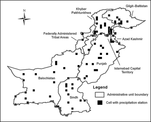
Either ground-based or grid-based precipitation data can be used to compute SPI. In this study, we calculated SPI for 3-, 6- and 12- month scales on a 0.25° by 0.25° latitude-longitude grid using a high-resolution daily precipitation data product for Asia, Monsoon Asia (v1101), obtained from APHRODITE’s Water Resources project (http://www.chikyu.ac.jp/precip). The compilation of APHRODITE precipitation is based on ground-based precipitation observations obtained from rain-gauge observation networks in Asian countries (Yatagai et al., 2009, Citation2012). shows the locations of APHRODITE rain gauges in Pakistan (including the northern territories-in-dispute, Gilgit–Baltistan and Azad Kashmir). During the data compilation, quality control was performed to handle errors in input raw data; the ratio of daily precipitation to long-term mean daily precipitation was interpolated at a resolution of 0.05°, and the interpolated precipitation field was released at 0.25° and 0.5° as final data products. Since similar results were obtained from SPI analysis using the data at the two resolutions, only the results at 0.25° are presented in this paper. Temporally, the Monsoon Asia (v1101) data product covers a 57-year period from 1951 through 2007. In checking the rain-gauge information associated with the precipitation product, it was found that the rain gauges used to create this data product in Pakistan in the 1950s were very sparse. Thus, in this study SPIs were calculated using only the data from 1960 through 2007.
Figure 1. Rain-gauge network in Pakistan.
As noted above, the calculated values of SPI depend on the probability model chosen for probabilistic precipitation modelling. In McKee et al.’s (Citation1993) work, which utilized the same SPI calculation algorithm employed in this study, precipitation was fitted to a two-parameter gamma distribution. The probability density function of the gamma distribution is
Table 2. Rejection rates of the Kolmogorov–Smirnov goodness-of-fit test for gridded APHRODITE data
The SPI series calculated using APHRODITE precipitation estimates for Pakistan has high dimensionality. To analyze the co-variability of SPI space-time fields, a principal component analysis (PCA) was performed in S mode (Richman, Citation1986). PCA is also known (in geoscience) as empirical orthogonal function (EOF) analysis (Lorenz, Citation1956). It is a nonparametric multivariate data analysis technique often used for dimension reduction. PCA essentially involves applying a linear transformation to project data onto a new space. The basis of the new space consists of eigenvectors of a covariance matrix of the data, which are orthonormal and called principal components (PCs). They are selected to maximize the variance of transformed variables in such a way that the first principal component has the largest variance any linear combination can have and the ith has the largest variance among linear combinations orthogonal to the (i – 1)th, etc. An inspection of the first several principal components that account for the majority of the variance of the transformed variances enables identification of the major spatial pattern and temporal modes in a high-dimensional data-set.
Results
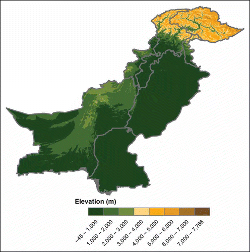
PCA of the SPI fields reveals that the first principal components (PC1) have not only the largest, but also the most dominant contributions to the total variance after the orthonormal linear transformation: on 3-, 6- and 12-month scales, the PC1 explained 52.8%, 53.4% and 51.9%, respectively, of the total variance. shows the loadings (correlation coefficients between the PC scores and the original variables) of the first principal component (PC1). A similar zonal pattern was identified across the three loadings maps: the correlations tend to be high and positive in central and southern Pakistan. The high-correlation region is centred on east Balochistan, southwest Punjab and north Sindh, which together cover much of the territory of Pakistan as well as the key agricultural areas of the country. The values of correlation coefficients are typically above 0.6. Low correlations (with typical correlation coefficients less than 0.3) are observed in northern Pakistan, covering Gilgit–Baltistan, northern Khyber Pakhtunkhwa and a small fraction of the westernmost area of Balochistan. A factor that might help explain the correlation variation between northern and central Pakistan is topography. Pakistan is located in the west of the Indian subcontinent, bounded by the Hindu Kush, the Himalayan and Karakorum ranges to the north and the Arabian Sea to the south. The areas with low SPI-PC1 score correlations on the northern frontier coincide with mountainous areas with average elevations greater than 3000 m above sea level ().
Figure 2. PCA loadings maps of SPI on (a) 3-month, (b) 6-month, and (c) 12-month scales.

Figure 3. Elevation in Pakistan.
The scores of PC1s on 3-, 6- and 12-month scales are shown in . These graphs serve to indicate the temporal variability of SPI series in regions in central and southern Pakistan with high positive correlations between SPI and PC1 score series identified in Figure 2. Visual inspection shows no obvious linear trend in any of the three PC1 score time series. To demonstrate this point more formally, the statistics computed from trend-detection analysis – using trend-free pre-whitening (Yue, Pilon, Phinney, & Cavadias, Citation2002) – are shown in . As suggested by the small values of Sen’s slope and Kendall’s p-value, no trend was detected in the analysis for PC1 scores at the three time scales ().
Figure 4. Scores of first principal component (PC1) for SPI on (a) 3-month, (b) 6-month, and (c) 12-month scales.
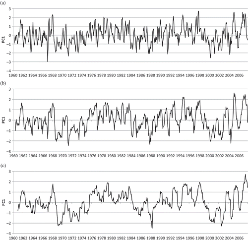
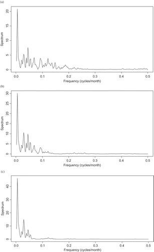
Although the PC1 score time series are free of linear trend, all three PC1 score series exhibit cyclic behaviours: periods of intensive drought incidence, which are indicated by frequent low values of PC1 scores, alternate with wet periods, indicated by frequent high PC1 score values. More specifically, according to the PC1 score series shown in Figure 4, we can identify three major drought-intensive periods between 1960 and 2007. These occurred in the late 1960s, the mid-1980s and the late 1990s, respectively. Each drought-intensive period lasted four to five years and was followed by a multi-year wet period. To quantify the observations on the cyclic behaviours of the PC1 score series noted above, a spectral analysis (Bloomfield, Citation1976; Percival & Walden, Citation1993) was carried out. Spectral analysis decomposes time series into linear combinations of sinusoids with different frequencies using the Fourier transformation technique. The periodogram, or estimated spectral density, from the analysis provides an indication of the contributions of sinusoids at varying frequencies to the data series: a relatively large periodogram value indicates a relatively greater contribution. shows periodograms for the time series of PC1 score on 3-, 6- and 12-month scales. In all three periodograms, the largest spike occurs at a frequency of 0.0052 cycles per month, which corresponds to a period of 1 / 0.0052 192 months, or 16 years. That is to say, the PC1 scores appear to observe a 16-year cycle.
Table 3. Results of trend detection for PC1 scores
Figure 5. Periodograms of PC1 scores on (a) 3-month, (b) 6-month, and (c) 12-month scales.
Implications for water resources management in Pakistan
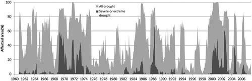
The spatiotemporal variability identified by PCA has immediate implications for water resources management in Pakistan. First, the PCA presented in the preceding section reveals that the variation of SPI series in central and southern Pakistan is strongly correlated with PC1 score series. This implies that drought tends to occur simultaneously in these regions, affecting a large part of the country. Figure 6 shows how the extent of the drought-affected area (as a percentage of the total area of the country) in different drought-intensity categories evolved during the study period according to the 12-month SPI fields. It provides further verification for the results of the PCA and the inferred implications. Similar patterns (not shown) were found for the 3- and 6-month SPI fields calculated in this grid-based analysis. The classification of drought intensity is based on the scheme shown in . The light shading represents the total area under any level of drought (mild + moderate + severe + extreme), and the dark shading represents the area affected by severe or extreme drought (severe + extreme). Since the regions in central and southern Pakistan with high positive SPI-PC1 score correlations account for the majority of the total land area in Pakistan, the drought-intensity variations in Figure 6 are dominated by the variations in these high-correlation regions. As is evident in , the extent of the drought-affected area expands as the PC1 score in Figure 4(c) drops. During the three identified main drought-intensive periods, more than 90% of Pakistan’s total territory was affected, and the percentages of area under severe and extreme drought were as high as 50–60%.
Figure 6. Temporal evolution of drought-affected area in Pakistan.
The large spatial extent of the drought-affected areas, plus the long duration of the drought-intensive periods, undoubtedly pose great challenges for water management in Pakistan. Pakistan is a country with a very strong anthropogenic impact on its natural water resources system (Oki & Kanae, Citation2006), meaning that water resources have been heavily appropriated for so-called productive uses. Agriculture is the main consumer of water resources. The Indus River boasts one of the largest irrigation systems in the world for a single river basin. Nationwide, nearly 90% of the total cultivated area, some 20 million ha, is equipped with irrigation systems (AQUASTAT, 2013), and 90% of all food produced in the country is derived from irrigated agriculture drawing on basin water resources. Importantly, the key agricultural areas are spatially correlated with drought areas, making it difficult to reduce adverse drought impacts through inter-regional trade within Pakistan.
The SPI is based on precipitation, and its value reflects the abundance or lack of precipitation during designated periods and on selected time scales (Briscoe & Qamar, Citation2007; Kamal, Citation2009). Drought, or reduced precipitation, usually intensifies tensions in water allocation. The large extent of droughts and the long accumulated duration of consecutive drought events call for concerted and dedicated efforts in water resources management across the country. We note that annual precipitation in the areas vulnerable to extensive and persistent droughts in central and southern Pakistan is rather low, and as a result, crop production in these areas relies heavily on irrigation water diverted from the Indus River, of which the majority of inflow comes from the mountains in northern Pakistan as well as neighbouring India and China. Further research is needed to analyze the relationship of drought occurrences in the irrigation command areas in Pakistan and head source areas in the upstream Indus Basin. Nevertheless, the findings in this paper may contribute to improved drought preparedness by highlighting the risks of synchronous droughts over vast, agriculturally important areas in Pakistan.
In addition to the above-discussed finding from PCA and its implications for water resources management, spectral analysis of cyclic behaviour in PC1 scores in this study also shows that the variation of PC1 scores, or drought and wetness occurrence in central and southern Pakistan, is under the influence of a long cycle, with a period of 16 years. This finding may imply some good news for water managers and policy makers. Periodicity implies predictability. If the periodicity does exist, there could be opportunities to develop better plans to prepare for the risks brought about by climate extremes. Of course, due to the limited length of the SPI series, there is considerable uncertainty in ascertaining long-term periodicity, and what causes this periodicity is still unclear. Additional future research is needed to further verify the existence of this low-frequency periodicity and to identify physical reasons for it.
Conclusions
Pakistan is a country facing a great threat of water scarcity. Drought, as a natural hazard, exacerbates the water-scarce situation and brings significant adverse socio-economic impacts. This paper investigated the spatiotemporal variability of drought incidence during 1960–2007 in Pakistan. The analysis was based on the calculation of Standardized Precipitation Index fields for 3-, 6- and 12-month scales using a gridded precipitation data product. PCA of the calculated SPI fields revealed that the incidence of drought in Pakistan is characterized by a large spatial extent of affected area and is influenced by a 16-year cycle, each cycle including a drought-intensive period which may last for several years. These identified patterns of drought incidence in Pakistan highlight the challenging nature of drought management in the country and the needs for well-coordinated water resources planning and drought preparedness, as well as effective and efficient emergency responses during drought events.
Acknowledgement
The research presented in this paper was supported by the CGIAR Research Program on Climate Change, Agriculture and Food Security (CCAFS) (under the project Impacts of Climate Extremes on Future Water and Food Security in South Asia and East Africa) as well as the CGIAR Research Program on Policies, Institutions, and Markets (PIM) through the Pakistan Strategy Support Program (PSSP). Any findings, conclusions and opinions expressed in this papers are those of the authors and do not necessarily reflect the views of the CGIAR Research Programs and PSSP.
References
- Abadie, A. (2002). Bootstrap tests for distributional treatment effects in instrumental variable models. Journal of the American Statistical Association, 97(457), 284–292.
- Agnew, C. T. (2000). Using the SPI to identify drought. Drought News Network, 12(1), 6–12.
- Ahmad, S., Hussain, Z. A., Qureshi, S., Majeed, R., & Saleem, M. (2004). Drought mitigation in Pakistan: Current status and options for future strategies. Working Paper 85. International Water Management Institute, Colombo, Sri Lanka.
- AQUASTAT, the Food and Agriculture Organization of the United Nations (FAO). Retrieved January 5, 2013, from http://www.fao.org/nr/water/aquastat/dbase/index.stm
- Bloomfield, P. (1976). Fourier analysis of time series: An introduction. New York, NY: Wiley.
- Bonaccorso, B., Bordi, I., Cancielliere, A., Rossi, G. , & Sutera, A. (2003). Spatial variability of drought: An analysis of the SPI in Sicily. Water Resources Management, 17, 273–296.
- Bordi, I., Frigio, S., Parenti, P., Speranza, A. , & Sutera, A. (2001). The analysis of the Standardized Precipitation Index in the Mediterranean areas: Regional patterns. Annals of Geophysics, 44(5–6), 979–994.
- Briscoe, J. , & Qamar, U. (2007). Pakistan’s Water economy running dry. Karachi, Pakistan: Oxford University Press, Commissioned by World Bank.
- Chaudhry, Q. Z. , & Rasul, G. (2004). Agroclimatic classification of Pakistan, Science Vision, 9(1–2 & 3–4), (July–Dec, 2003 & Jan–Jun, 2004), 59.
- Gibbs, W. J. , & Maher, J. V. (1967). Rainfall deciles as drought indicators. Bureau of Meteorology Bulletin No. 48. Melbourne: Commonwealth of Australia.
- Heim Jr, R. R. (2002). A review of twentieth-century drought indices used in the United States. Bulletin of the American Meteorological Society, 83(8), 1149–1165.
- Kamal, S. (2009). Pakistan’s water challenges: Entitlement, access, efficiency, and equity. In M. Kugelman. & R. M. Hathaway (Eds.), Running on empty: Pakistan’s water crisis. Washington, DC: Woodrow Wilson International Center for Scholars. Retrieved from www.wilsoncenter.org.
- Labedzki, L. (2007). Estimation of local drought frequency in central Poland using the Standardized Precipitation Index SPI. Irrigation and Drainage, 56(1), 67–77.
- Lorenz, E. N. (1956). Empirical orthogonal functions and statistical weather prediction (48pp). Scientific Report No. 1, Statistical Forecasting Project. Cambridge, MA: MIT.
- Massey, F. J. (1951). The Kolmogorov-Smirnov test for goodness of fit. Journal of the American Statistical Association, 46(253), 68–78.
- McKee, T. B., Doesken, N. J., & Kleist, J. (1993). The relationship of drought frequency and duration to time scales. Preprints, 8th Conference on Applied Climatology, pp. 179–184. January 17–22, Anaheim, California.
- Oki, T. , & Kanae, S. (2006). Global hydrological cycles and world water resources. Science, 313(5790), 1068–1072.
- Pakistan Meteorological Department. (2013). Drought Bulletin of Pakistan: January–March 2013
- Palmer, W. C. (1965). Meteorological drought. Research Paper No. 45. Washington, DC: U.S. Department of Commerce Weather Bureau.
- Palmer, W. C. (1968). Keeping track of crop moisture conditions, nationwide: The new Crop Moisture Index. Weatherwise, 21, 156–161.
- Percival, D. B. , & Walden, A. T. (1993). Spectral analysis for physical applications. Cambridge: Cambridge University Press.
- Raziei, T., Bordi, I. , & Pereira, L. S. (2011). An application of GPCC and NCEP/NCAR datasets for drought variability analysis in Iran. Water Resources Management, 25, 1075–1086.
- Richman, M. B. (1986). Rotation of principal components. Journal of Climatology, 6, 293–335.
- Santos, J. F., Pulido-Calvo, I. , & Portela, M. M. (2010). Spatial and temporal variability of droughts in Portugal. Water Resources Research, 46, W03503. doi:10.1029/2009WR008071
- Shafer, B. A., & Dezman, L. E. (1982). Development of a Surface Water Supply Index (SWSI) to assess the severity of drought conditions in snowpack runoff areas. In Proceedings of the Western Snow Conference, Reno, NV, April 19–23, 1982, pp. 164–175.
- Tsakiris, G. , & Vangelis, H. (2004). Towards a drought watch system based on spatial SPI. Water Resources Management, 18, 1–12.
- World Bank. (2005). Pakistan country water resources assistance strategy – Water economy: Running dry. South Asia Region, Agriculture and Rural Development Unit Report No. 34081-PK. Washington, DC.
- World Meteorological Organization. (2012). Standardized precipitation index user guide. WMO-No 1090.
- Yatagai, A., Arakawa, O., Kamiguchi, K., Kawamoto, H., Nodzu, M. I. , & Hamada, A. (2009). A 44-year daily gridded precipitation dataset for Asia based on a dense network of rain gauges. SOLA, 5, 137–140.
- Yatagai, A., Kamiguchi, K., Arakawa, O., Hamada, A., Yasutomi, N. , & Kitoh, A. (2012). APHRODITE: Constructing a long-term daily gridded precipitation dataset for Asia based on a dense network of rain gauges. Bulletin of the American Meteorological Society, 93(9), 1401–1415.
- Yue, S., Pilon, P., Phinney, B. , & Cavadias, G. (2002). The influence of autocorrelation on the ability to detect trend in hydrological series. Hydrological Processes, 16, 1807–1829.
- Zargar, A., Sadiq, R., Naser, B. , & Khan, F. I. (2011). A review of drought indices. Environmental Reviews, 19, 333–349.