
Abstract
This review paper critically examines one of the most popular flood hydrograph modelling techniques for ungauged basins, the synthetic unit hydrograph (SUH), and its recent developments and advances. For this purpose, the SUH models were first grouped into four main classes, as follows: (a) traditional or empirical models; (b) conceptual models; (c) probabilistic models; and (d) geomorphological models. It was found that the geomorphological class is the most useful and interesting, since it is able to employ topographic information, so limiting the role of the calibration parameters. This review is expected to be helpful to hydrologists, water managers and decision-makers searching for models to study the flood hydrograph, modelling techniques and related processes in ungauged basins. It was completed as the International Association of Hydrological Sciences (IAHS) Decade (2003–2012) on predictions in ungauged basins (PUB), drew to a close.
Editor D. Koutsoyiannis; Associate editor S. Grimaldi
Citation Singh, P.K., Mishra, S.K., and Jain, M.K., 2013. A review of the Synthetic Unit Hydrograph: from the empirical UH to advanced geomorphological methods. Hydrological Sciences Journal, 59 (2), 239–261.
Résumé
Cet article de synthèse examine de façon critique l’une des techniques les plus courantes de modélisation des hydrogrammes de crue pour les bassins non jaugés, à savoir l’hydrogramme unitaire synthétique (HUS), ses développements et les progrès récents. A cet effet, les modèles d’HUS ont d’abord été regroupés comme suit en quatre grandes catégories: (a) les modèles traditionnels ou empiriques, (b) les modèles conceptuels, (c) les modèles probabilistes, et (d) les modèles géomorphologiques. Nous avons constaté que la classe des modèles géomorphologiques est la plus utile et la plus intéressante, car elle est susceptible d’utiliser l’information topographique, limitant ainsi le rôle des paramètres de calage. Cette revue devrait être utile aux hydrologues, aux gestionnaires de l’eau et aux décideurs à la recherche de modèles pour étudier l’hydrogramme de crue, les techniques de modélisation et les processus connexes dans les bassins non jaugés. Elle a été réalisée alors que la décennie 2003–2012 de l’Association internationale des sciences hydrologiques (AISH) sur la prévision dans les bassins non jaugés (PUB), touchait à sa fin.
1 INTRODUCTION
Unit hydrograph (UH) theory is a potentially powerful tool in watershed hydrology analogous to the unit-impulse response (UIR) function in fields such as electronics and telecommunication or electrical and structural engineering. More than 75 years since the inception of UH theory by Sherman (Citation1932), it is still one of the methods most widely used for development of Flood Prediction and Warning Systems (FPWSs) for gauged basins with observed rainfall–runoff data. Sherman paved the way for the advancement of watershed rainfall–runoff analysis with his UH technique. In its development, Sherman made assumptions that are the basis for much of modern hydrology; these can be summarized as: The hydrologic system is linear and time invariant (Dooge Citation1973). While failing to describe the runoff distribution precisely, because of its limiting assumptions, the theory is recognized as being a good predictive tool and the UH is seen to reflect the characteristics of the basin it represents. However, this data-driven traditional approach limits the derivation of UH to gauged watersheds only. The synthesis of the UH from physical basin characteristics is necessary for extension of the theory to ungauged basins (Hoffmeister and Weisman Citation1977). In this context, many studies have been completed relating UH or instantaneous unit hydrograph (IUH) parameters to their basin parameters to synthesize a UH for an ungauged basin, e.g. Bernard (Citation1935), Snyder (Citation1938), Taylor and Schwarz (Citation1952), Gray (Citation1961), Hedman (Citation1970), Murphey et al. (Citation1977), Boyd et al. (Citation1979), Rodríguez-Iturbe and Valdés (Citation1979), Croley (Citation1980), Gupta et al. (Citation1980), Aron and White (Citation1982), Rosso (Citation1984), Singh et al. (Citation1985), Singh (Citation1988), Bras and Rodriguez-Iturbe (Citation1989), Haan et al. (Citation1994), Usul and Tezcan (Citation1995), Yen and Lee (Citation1997), Bhadra et al. (Citation2008) and Bhunya et al. (Citation2009).
Sherman (Citation1932) was the first to see the possibilities of extending the UH theory he had developed. He listed the physical basin characteristics that he thought would be reflected in a UH, and which could be used to estimate the streamflow for an ungauged basin from given rainfall data. These characteristics were drainage area, size and shape, distribution of water courses, slope of main stream, slope of valley sides and pondage due to surface or channel obstructions. Sherman’s idea has been the basis of many synthetic unit hydrograph (SUH) procedures (Hoffmeister and Weisman Citation1977). Most procedures seek to establish relationships between parameters used to describe the UH and parameters used to describe the basin. The procedures differ either in the relationships established or in the methodology employed. The Sherman UH concept used for estimating the storm runoff hydrograph at the gauging site in a catchment corresponding to a rainfall hyetograph is a widely accepted and admired tool in hydrological analysis and synthesis. It is one of the first tools available to the hydrological and water resources community to determine the complete hydrograph shape rather than the quantum of peak discharge only (Todini Citation1988). As discussed above, the UH concept needs observed rainfall–runoff data at the gauging site for hydrograph generation; the paucity of such data sparked the idea of the SUH concept. The term “synthetic” here denotes the UH derived from watershed characteristics rather than rainfall–runoff data.
Research on the hydrology of ungauged basins has received much attention since the early 1990s, and especially during the decade 2003–2012 on Predictions in Ungauged Basins (PUB) of the International Association of Hydrological Sciences. The main purpose of this review paper is to assess the progress in the development of SUH techniques in the past and to provide a quick reference guide for researchers exploring new methods that can be used for hydrological prediction in ungauged basins. In this study, the available SUH models have been classified into four groups as: traditional (or empirical), conceptual, probabilistic and geomorphological. The traditional SUH models are based on different empirical equations and have certain region-specific constants/coefficients varying over a wide range. The conceptual models are based on the continuity equation and linear storage discharge relationship. Using these models, the basin is simulated by either a linear channel (LC) or a reservoir. The probabilistic or probability distribution function-based models use a parametric approach and employ the density functions for SUH derivation. The geomorphological class uses basin geomorphology to develop IUH for flood hydrograph modelling for ungauged basins. The following sections deal with the models grouped under these four classes and critically review and discuss their applicability and limitations, and their future applications.
2 TRADITIONAL SYNTHETIC UNIT HYDROGRAPH METHODS
The beginning of the SUH concept can be traced back to the distribution graph proposed by Bernard (Citation1935) to synthesize UH from watershed characteristics, rather than the rainfall–runoff data. Examples of some of the traditional methods of SUHs include Snyder (Citation1938), Taylor and Schwarz (Citation1952) and Soil Conservation Service (SCS Citation1957). In traditional synthetic unit hydrograph (TSUH) development, some degree of subjectivity is involved in fitting the remaining points on the SUH. In addition, simultaneous adjustments are also required to ensure that the area under the SUH is unity corresponding to unit rainfall-excess. The empirical equations encountered have certain constants, which vary over a wide range. However, despite their inconsistencies, these methods are still widely used in engineering problems; brief descriptions of some are given here.
2.1 Snyder method
Snyder (Citation1938) was perhaps the first to establish a set of empirical relations among watershed characteristics, such as area (Aw) (km2); length of main stream (L) (km); and the distance from the watershed outlet to a point on the main stream nearest to the centre of the area of the watershed (Lc) (km) and the three basic parameters of the UH, i.e. tp, the lag or time to peak (h), Qp, the peak discharge rate (m3/s), and tb the base time (d), to describe the shape of the UH. These relationships can be expressed as:
where Ct and Cp are non-dimensional constants. Equations (1) and (2) were obtained from the study of catchments varying in size from 10 to 10 000 square miles (26–259 000 km2) in the USA. Snyder (Citation1938) found Ct to vary from 1.8 to 2.2 and Cp from 0.56 to 0.69. More recently, Das (Citation2009) reported Ct and Cp as 0.65 and 0.94, respectively, for the Ramganga catchment in the Himalayan range, India. Equations (1)–(3) hold good for rainfall-excess duration (or unit duration) tR = tp/5.5.
However, if the duration of rainfall-excess, say tR1, differs from the above defined duration (tR), a modified lag time tMP is determined as:
One can sketch any number of UHs through the three known characteristic points of the UH, i.e. Qp, tp and tb, with its specific criteria, i.e. that the area under the SUH be unity. To overcome this ambiguity associated with Snyder’s method, the US Army Corps of Engineers (USACE Citation1940) proposed empirical relations between widths of the UH at 50% (W50) and 75% (W75) of Qp as a function of Qp/Aw = qp, expressed as: W50 = 830/qp1.1 and W75 = 470/qp1.1. The units of W50 and W75 are hours. Thus, one can draw a smooth curve through the seven points (Qp, tp, tb, W50 and W75) relatively more easily with less degree of ambiguity, and can keep the area under the SUH as unity. However, in practical applications, this procedure is very tedious and involves a great degree of subjectivity and error due to the manual fitting of the points and simultaneous adjustments for the SUH area.
2.2 Taylor and Schwarz model
The Taylor and Schwartz (TS) model was proposed by Taylor and Schwarz (Citation1952) for SUH derivation using the data of 20 watersheds having drainage areas varying from 20 to 1600 mi2 (52–4144 km2). While deriving the SUH, the model specially considers the average slope of the main channel of the watershed and the other watershed characteristics, i.e. Aw, L and Lc similar to those in Snyder’s method. The average slope of the main channel is determined as:
where Sc is the average slope of the main channel, Si is the slope of the ith reach of the main channel and N is the total number of reaches.
The empirical equations relating the UH characteristics to watershed characteristics are expressed as:
where m1 = 0.212 (L Lc)-°.36, m2 = 0.121Sc.142 − 0.05 − m1, D is rainfall duration, and tp, L, Lc, tb, tr are the same as in Snyder’s method. However, the peak discharge rate (Qp) is expressed in units of ft3 s-1 mi-2. Similar to Snyder’s method, the TS model also estimates W50 and W75 using the equations proposed by USACE (Citation1940) for smooth sketching of the SUH. From equation (8), tb appears to be close to five times tp (Singh Citation1988). However, the basic inconsistencies associated with the TS model remain the same as with Snyder’s method.
2.3 Soil Conservation Service method
The SCS (Citation1957) method of the US Department of Agriculture (USDA), developed by Victor Mockus, synthesizes the UH using a specific average dimensionless UH derived from the analysis of a large number of natural UHs for watersheds of varying size and geographic location (Singh Citation1988). To enable definition of the time base, tb, in terms of time to peak, tp, and time to recession, trc, the SCS method represents the dimensionless UH as a triangular UH, which further facilitates the computation of the runoff volume (V) and peak discharge (qp) as:
where qp is in mm h-1 mm-1; V is in mm; tp and trc are in hours. To determine the complete shape of the SUH from the non-dimensional (q/qp versus t/tp) hydrograph, the time to peak is computed as:
where tL is lag time (h) from the centroid of rainfall-excess to peak discharge (qp) and tr is the excess-rainfall duration (unit duration) (h). The lag time (tL) can be estimated from the watershed characteristics using the curve number (CN) procedure as:
where L is the length of the main stream or hydraulic length of the watershed (m), CN is the CN (50 ≤ 95) and Y is the average catchment slope in (m/m).
Alternatively, equation (11) can be expressed as:
where Qp is peak discharge in m3 s-1 cm-1 of rainfall-excess, and Aw is watershed area in km2. Thus with known qp, tp and a specified dimensionless UH, the SUH can be easily derived.
3 CONCEPTUAL SYNTHETIC UNIT HYDROGRAPH METHODS
This section discusses the popular conceptual models of Clark (Citation1945) and Nash (Citation1957) along with some recently developed conceptual models used for SUH derivation. We also explore some of the conceptual models already available in the hydrological literature which have ample potential to be transmuted into SUH, and thus require the attention of the PUB research community for their analysis.
3.1 Clark IUH model
According to Chow (Citation1964), Clark (Citation1945) proposed his model after an era of hydrology referred to as the Period of Empiricism from 1900 to 1930. These years saw the development of many unsatisfactory empirical equations that often relied on the judgement and experience of the user. Clark was part of what is considered the Period of Rationalization encompassing the years from 1930 to 1950. As Clark states in his paper, the studies done since the 1930s had “improved the concept and understanding of physical factors which influence runoff and flood producing capacity of streams” and subsequently the development of improved UH and flood routing tools. Clark’s method for developing an SUH involves the application of an instantaneously applied unit (1 inch or 1 mm) of rainfall excess over a watershed and thereafter, the precipitation is mathematically conveyed to the watershed outlet through two components: a translation hydrograph and a linear reservoir (LR) routing.
For derivation of an IUH, the Clark model uses two parameters: (a) time of concentration (TC) in hours, and (b) storage coefficient (K) in hours of a single LR, in addition to the time–area diagram. The governing equation of the Clark IUH model can be expressed as:
where Ui is the ith ordinate of the IUH and Ai the ith ordinate of the time–area diagram; C1 and C2 are Clark’s routing coefficients and can be computed by the following expressions:
where Δt is the computational interval in hours.
Finally, a UH of desired duration (D) is derived using the equation:
where Ui is the ith ordinate of the UH of D-hour duration and computational interval Δt hours; and N is the number of computational intervals in D-hours, D/Δt.
“It was Clark’s intention that the synthesized unit hydrograph would reflect the influence of the shape of the drainage area, provide for the separation of hydrograph features due to specific drainage area characteristics, and have a standardized calculation procedure that would yield similar results when used by different people” (Kull and Feldman Citation1998). Although not stated as a purpose, Clark’s model was the first fully time-distributed SUH technique. However, for ungauged basins, TC and K are difficult to estimate (Kull and Feldman Citation1998).
3.2 Nash IUH model
Nash (Citation1957) developed a conceptual model based on a cascade of n equal LRs with equal storage coefficient K for derivation of the IUH for a natural watershed. Notably, in the model formulation, an instantaneous unit depth of effective rainfall is allowed into only the farthest (nth) reservoir in a series (in the Nash model the reservoir closest to the outlet is the first reservoir and the farthest in the series is the nth reservoir) and is then routed through the remaining reservoirs. The outflow of each reservoir serves as the inflow into the next reservoir in the series as the flow moves towards the outlet of the watershed. The outflow of the first reservoir of the series, at the outlet of the watershed, is considered to be the IUH for the watershed. The analytical form of the model can be expressed as:
where q(t) is the depth of runoff per unit time per unit effective rainfall. It is noteworthy that parameter n is dimensionless and K has the unit of time. The area under the curve defined by equation (19) is unity. Thus, the rainfall-excess and direct surface runoff depths are equal to unity. The parameters n and K are often referred to as the shape and scale parameters of the Nash model, respectively, which can be computed using the method of moments or empirical equations available in the literature (e.g. Singh Citation2000, Bhunya et al. Citation2003). To obtain the SUH, the parameters of equation (19) are related to catchment characteristics. The IUH (equation (19)) is used to derive the resultant flood hydrograph for a given input rainfall.
It is one of the most popular and widely accepted approaches to approximating the real system (Bhunya et al. Citation2008). The model is frequently used for determining the direct runoff hydrograph, e.g. Singh et al. (Citation1985), Boufadel (Citation1998), Singh (Citation2000), Jeng and Coon (Citation2003), Agirre et al. (Citation2005) and Bhunya et al. (Citation2008). The Nash model has also been applied successfully in sedimentation and environmental engineering by Kumar and Rastogi (Citation1987), Sharma et al. (Citation1992) and Sharma and Murthy (Citation1996). More recently, Singh et al. (Citation2008) and Bhunya et al. (Citation2010) developed a conceptual sediment graph model based on the Nash model for estimation of time-distributed sediment yield (sediment graph).
However, in spite of its wider applicability, the Nash model has been a topic of much discussion among the hydrological community for its inherent discrepancies, including the following:
a conceptual flaw is that the instantaneous unit rainfall is input into only the farthest reservoir from the outlet of the watershed; this is equivalent to saying that for a given watershed, only the farthest area from the outlet receives any rainfall, and that this area receives the entire unit rainfall (Jeng and Coon Citation2003);
the value of n, which should ideally be an integer, generally comes out to be a fractional value when derived from observed data (Singh Citation1988) and forms a major limitation; and
the model ignores the concept of translation, essential for describing the behaviour of a dynamic system, and assumes a uniform storage coefficient K to derive the output at the basin outlet.
3.3 Dooge IUH model
Dooge (Citation1959) used the concept of a LC and represented the basin (system) by a series of LCs and LRs. The outflow from the LC was represented by a time–area diagram which, together with outflow from the preceding sub-area, serves as the inflow to the LR. The expression developed for the IUH can be expressed as:
where S is the input volume taken as unity; T is the total transmission time of the basin (=LC with L as the total channel length of the basin and C the translation coefficient for all LCs); i is the order of reservoirs equal to 1, 2, 3 … counted downstream to the basin outlet; i(τ) is the function of τ representing an integer equal to the order number of the sub-area; Ki is the storage coefficient of the ith reservoir; D is the differential operator (d/dt); δ(t – τ) is the Dirac-delta function, where t is the elapsed time, τ is the translation time between the elements in the sub-area and the outlet; and ω is the ordinate of a dimensionless time–area diagram.
3.4 Nonlinear IUH model
Singh (Citation1964) developed an IUH model based on a nonlinear modelling approach considering the overland and channel flow components separately in the rainfall–runoff process. The model consists of a LC of translation coefficient τ and two LRs of different storage coefficients K1 and K2, in series. The IUH model can be expressed as:
where K1 and K2 are the storage coefficients of the first and second LRs; T is the total translation time of the basin. Surprisingly, the model has not received as much attention from the research community compared to the Nash and Clark models, despite having a translation component incorporated in the rainfall–runoff simulation process.
3.5 Urban parallel cascade IUH model
In an attempt to improve the parallel cascade modelling (Diskin Citation1964) concept, Diskin et al. (Citation1978) proposed an urban parallel cascade (UPC) IUH model by representing the basin system as the combination of two parallel branches having a series of equal LRs and each branch representing the impervious area and pervious area of the catchment. Mathematically, the proposed model can be expressed as:
where αA and αB are the scaling factors representing the fractions of impervious and pervious areas in the watershed and αB = (1 – αA); nA, KA and nB, and KB represent the number of LRs and their storage coefficients, respectively, for branches A and B, as shown in .
Fig. 1 Structure of an urban parallel cascade IUH model.
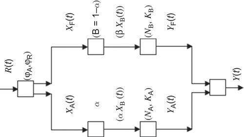
The model has greater flexibility than the single cascade model of Nash. One of its most striking features is that it estimates separately the contribution of the impervious area of the watershed and that of the pervious area, and is thus useful for deriving flood hydrographs both for existing conditions in a watershed and for proposed changes in the degree of urbanization. Despite its uniqueness, the model has not been explored regarding its capabilities for better hydrological results. Second, the model can also be considered for SUH derivation.
3.6 Hybrid model
Given that n (Section 3.2) should ideally be an integer value and simultaneously, to simulate a complete IUH with a rising limb (or tp > 0), the Nash model requires a minimum of two reservoirs connected in series. Building on this idea, Bhunya et al. (Citation2005) developed a hybrid model (HM) for derivation of SUH by splitting the Nash single LR into two serially connected reservoirs of unequal storage coefficients (one hybrid unit) to give a physically realistic response, as shown in . The analytical expression of the model for two hybrid units in series is:
Fig. 2 Arrangement of the first and second units of the hybrid model.
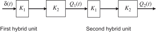
where Q2(t) is the output from the second hybrid unit (mm h-1 mm-1); and K1 and K2 are the storage coefficients of the first and second reservoirs (h), respectively, of each hybrid unit. Equation (23) represents the output response function of the second hybrid unit due to a unit impulse perturbation at the inlet of the first hybrid unit and defines the complete shape of the IUH.
3.7 Extended hybrid model
Given that the concept of translation is an essential component to describe the associated dynamism of hydrological systems (Dooge Citation1959, Diskin Citation1964, Singh Citation1964), Singh et al. (Citation2007) modified the HM model by inserting a LC between the two LRs having different storage coefficients, to derive an SUH. The basin system was represented as a series of hybrid units, where each hybrid unit consists of two LRs connected by a LC in a specific order, i.e. (LR-LC-LR) as shown in . The analytical geometry of the model for two hybrid units in series is expressed as:
Fig. 3 Representation of a basin system by a series of hybrid units.
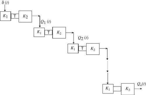
where Q2(t) is the output from the second hybrid unit (m h-1 m-1) or from the system; K1 and K2 in units of hours are the storage coefficients of the first and second LRs, respectively and T (h) is the translation time of the LC. It can be seen that equation (24) reduces to the HM model for T = 0 and the Nash model for K2 = T = 0 for a series of two hybrid units.
In summary, it can be inferred from the above analytical review that a number of available conceptual models can also be further explored for their transmutation into SUH models.
4 PROBABILITY DISTRIBUTION FUNCTION-BASED SUH METHODS
Use of probability distribution functions as SUH has a long successful hydrological history. Due to similarity in the shape of statistical distributions and a conventional UH, several attempts have been made in the past to use their probability density functions (pdfs) for derivation of the SUH. In practice, two approaches are followed for deriving a UH from recorded flood hydrographs and simultaneous rainfall records. The first is a non-parametric approach based on a discretization technique, i.e. determination of a model at a finite number of discrete points. This includes the least-squares method (Snyder Citation1955), matrix inversion (Eagleson et al. Citation1966), linear programming (Collins Citation1939), nonlinear programming (Mays and Taur Citation1982) and the transfer function method (Yang and Han Citation2006).
The second one is a parametric approach that fits some prescriptive functional curves with a limited number of parameters, and these parameters are estimated by means of optimization using an objective function or through any suitable approach. For instance, Nash (Citation1957) derived an IUH (equation (19)) based on the concept of n LRs of equal storage coefficient and showed that the IUH shape can be represented by a two-parameter gamma distribution (2PGD). He derived the parameters of the 2GPD by the method of moments using observed hyetographs and hydrographs. The non-parametric methods are believed to be more accurate because they use a larger number of points for UH derivation. Therefore, they are widely used for UH derivation despite the disadvantage that there are a large number of correlated parameters in the UH model, which makes the estimation problem ill-formed and sometimes yields negative UH ordinates. Further, the large number of parameters involved in the derivation of the UH using these methods can lead to the problems of computational instability, which restricts the practical application of these techniques.
In contrast, the parametric approach fits the UH through selected salient points such as (tp, qp), (tp, ti) or (qp, ti), where tp is the time to peak (T), qp is peak runoff rate (T−1) and ti is the point of inflection after the peak (T). The parametric approach has also been used in SUH derivations, with the most common analytical forms being the triangular and the gamma-pdf (Koutsoyiannis and Xanthopoulos Citation1989). Their simplicity and ease of development can characterize these SUHs as they require less data and yield a smooth and single-valued shape corresponding to one unit runoff volume, which is essential for UH derivation. The SUH methods of Gray (Citation1961), Croley (Citation1980), Aron and White (Citation1982), Singh and Chowdhury (Citation1985), McCuen (Citation1989), Haktanir and Sezen (Citation1990), Singh (Citation2000), Bhunya et al. (Citation2003, Citation2008, Citation2009) are but a few of them. Singh (Citation1987) explored the applicability of the Weibull distribution derived from the Principal of Maximum Entropy (POME) in hydrological modelling. Koutsoyiannis and Xanthopoulos (Citation1989) presented eight suitable analytical forms for UH originated from known pdfs or their transformations. The proposed distributions can be explored for SUH derivation. Haktanir and Sezen (Citation1990) explored the applicability of 2PGD and three-parameter beta distributions (3PBD) for SUH derivation. Following this, Bhunya et al. (Citation2007) explored the potential of four popular pdfs, i.e. 2PGD, three-parameter beta (3PBD), two-parameter Weibull (2PWD), and one-parameter chi-square distribution (1CSD) to derive SUH.
Recently, Nadarajah (Citation2007) explored the usefulness of 11 of the most flexible probability distributions for SUH derivation. He also derived expressions for the unknown parameters in terms of the time to peak (tp), the peak discharge (qp) and the time base (tB). Sarkar et al. (Citation2010) explored the adequacy of several distributions for UH derivation. This section chronologically reviews some of the prominent works related to the application of distribution functions for SUH derivation.
4.1 Gray’s method
Gray (Citation1961) developed a dimensionless graphical (empirical in nature) procedure based on the 2PGD function and watershed characteristics to derive an SUH. The geometry of the dimensionless graph can be expressed as:
where Qt/PR = percentage flow/0.25 PR at any given (t/PR) value; PR is the time from beginning of surface runoff to the occurrence of peak discharge (minutes); γ′ is a dimensionless parameter = γPR; λ′ is shape parameter = 1+ γ′; γ is a scale parameter; and Γ is the gamma function. One of the striking features of the study is that 2PGD was used for SUH derivation in the early 1960s and hence serves as a way for pdf application in SUH derivation.
4.2 Croley method
The 2PGD is ideal for use as a hydrograph model since it is predicted from physical–conceptual models (Bedient and Huber Citation2002). It has also been used to represent both hydrographs and dimensionless hydrographs by several agencies and individuals such as SCS (Citation1957), Haan and Barfield (Citation1978), and Boufadel (Citation1998). Following this, Croley (Citation1980) developed an SUH by fitting 2PGD for different sets of boundary conditions: (tp, qp), (tp, ti) or (qp, ti). These boundary conditions are used to estimate the parameters n and K of the distribution. The general expression for SUH is:
where ti is the point of inflection [T], qp is the peak discharge per unit area per unit effective rainfall [T-1], tp is the time to peak (T) and n and K are the shape and scale parameters, respectively. It is interesting to note that if V corresponds to the volume of runoff produced by a unit depth of rainfall-excess uniformly applied both spatially over the watershed area and temporally over the storm duration, q(t) (equation (26)) is by definition, the “UH” for that area and for that storm duration.
Thus, the method provides an initiation to working with parametric expressions of probability distribution functions for SUH derivation. The works of Singh (Citation2000) and Bhunya et al. (Citation2003) seem to be much inspired by Croley’s work. Jeng (Citation2006) developed a continuous time function with two parameters for a synthetic curvilinear dimensionless unit hydrograph (SCDUH) using 2PGD. The equations of continuous time functions thus derived are useful and can be used in place of the Natural Resources Conservation Service (NRCS) CDUH tabulation and the NRCS linear triangular UH.
4.3 Transmutation approach
Singh (Citation2000) transmuted the traditional methods of SUH, e.g. Snyder, SCS, and the Gray method into a gamma distribution in a very lucid and simplified manner. The approach gives a smooth-shaped SUH and the area under it is guaranteed to be unity. Specifically, the possible unified conceptual interpretation of the popular SUHs in line with the conceptual models of IUH was presented. Assuming that equation (19) represents a UH of unit duration, the condition at the peak (t = tp) dq(t)/dt, yields:
Using equations (19) and (28), a simple analytical expression relating the number of LRs n and a dimensionless term β was developed as:
where β is a product of peak flow rate qp and time to peak flow rate tp. The parameter β is also known as the shape factor and has generally been observed to vary between 0.35 and 1.25. Its value is greater for steep and fast-responding catchments and is less for slow-responding catchments in flat regions. Inversion of equation (29) gives the value of n for a known value of β.
Substituting the approximate expression for the gamma function in equation (29), the following simple analytical equation for inverting equation (29) was obtained as:
Equation (30) can be used to calculate β, if n is known from other sources. It was found that equation (30) gives slightly higher values of n than its true value and the percentage error in n decreases with an increase in the value of β.
4.4 Simplified gamma approach
Bhunya et al. Citation(2003) introduced simplified versions of 2PGD to derive SUHs more conveniently and accurately than the popular Snyder, SCS, Gray and Transmutation approaches. They derived simple relationships between n and β, to obtain simplified versions of the gamma distribution for SUH derivation as:
where COD is the coefficient of determination. Hence, for partial data availability conditions or ungauged catchments, equations (31)–(32) and (28) can be used for estimation of parameters n and K, respectively, and thus the complete shape of the SUH. A relationship between λ and β was also developed as:
According to equation (33), β varies not only with the physical characteristics of the catchment, but also with its storage characteristics, which, in turn, depend on storm characteristics. Thus, the approach corrects the previous finding of Rodríguez-Iturbe and Valdés (Citation1979) and Singh (Citation2000) that β varies only with the physical characteristics of the catchment.
5 GEOMORPHOLOGICAL INSTANTANEOUS UNIT HYDROGRAPH-BASED SUH METHODS
The geomorphological models, coupling the principles of hydrological systems with quantitative geomorphology, were proposed to represent the IUH of a given basin, and are popularly known as geomorphological instantaneous unit hydrograph (GIUH) models. In this regard, several attempts were made in the past to establish relationships between the parameters of the models for ungauged catchments, and the physically measurable watershed characteristics; e.g. Bernard (Citation1935), Snyder (Citation1938), Taylor and Schwarz (Citation1952), Gray (Citation1961), Boyd (Citation1979), and Boyd et al. (Citation1979). However, the pioneering works of Rodríguez-Iturbe and Valdés (Citation1979), Valdés et al. (Citation1979), Rodríguez-Iturbe et al. (Citation1979) and Gupta et al. (Citation1980), which explicitly integrate the geomorphology details and the climatological characteristics of a basin, in the framework of travel time distribution, are the boon for streamflow synthesis in ungauged basins or cases with partial information on storm event data (Singh et al. Citation1985).
Recently, hydrologists have found it more convenient to couple the distribution function-based approach with the classical GIUH approach for development of SUH models by harvesting the geographic information systems (GISs) and remote sensing (RS) technologies. This section deals with the GIUH approach right from its origin to the most recent developments and applications in hydrological sciences.
As discussed in Section 3.2, Nash (Citation1957) built a theory on an analogy between the basin and a series of LRs and proposed a gamma-law type analytical expression of the UH. The main point of this model is the gamma-law type, since Nash considered it to be the characteristic basin UH shape. For the same a priori reason, much work in hydrological sciences is based on this model only. Thereafter, the idea of identifying a basin-scale transfer function (TF) from some geomorphological characteristics emerged in order to give physical basis to the UH. Thus, linking quantitative geomorphology with basin hydrological characteristics can provide a simple way to understand the hydrological behaviour of different basins, particularly ungauged ones. These characteristics relate to the physical characteristics of the drainage basin as well as the drainage network. The physical characteristics of the drainage basin include drainage area, basin shape, ground slope and centroid. Whereas in a drainage network, the important channel characteristics include the number of channels of different orders, their lengths and slopes, etc. shows the different useful geomorphological parameters of a basin.
Table 1 Formulae used to estimate different geomorphological parameters.
Dooge (Citation1959) initiated a kind of quest by affirming that such a theory would be gratifying and “should help to remove many of the subjective elements from unit hydrograph analysis and also to release the problem of synthesis from its present dependence on empirical relationships derived from localized data”. Regarding the geomorphological basis itself for UH identification, Rodríguez-Iturbe and Valdés (Citation1979) formulated the geomorphological IUH (GIUH) trying to reach universality “with the conviction that the search for a theoretical coupling of quantitative geomorphology and hydrology is an area which will provide some of the most exciting and basic developments of hydrology in the future”. The roots can be traced back to Horton (Citation1945) who originated the quantitative study of channel networks and developed a system for ordering stream networks and derived laws relating the stream numbers (N), stream lengths (L) and catchment area (A) associated with streams of different order. The quantitative expressions of Horton’s laws are:
where Nw is the number of streams of the order w, is the mean length of stream of order w and
is the mean area of basin of order w. RB, RL and RA represent the bifurcation ratio, length ratio and area ratio, respectively, whose values in nature are normally between 3 and 5 for RB, between 1.5 and 3.5 for RL and between 3 and 6 for RA.
5.1 The GIUH model
Rodríguez-Iturbe and Valdés (Citation1979) expressed the initial state probability of one droplet of rainfall in terms of geomorphological parameters as well as the transition state probability matrix. The final probability density function (pdf) of droplets leaving the highest-order stream into the trapping state is nothing but the GIUH. An exponential holding time mechanism, equivalent to that of an LR was assumed in its conceptualization, as discussed here.
Let fTs,i(t) be an exponential pdf of travel time Ts,i which is a subset of Ts, the part of the travel time of the specific path s through Strahler state i within the catchment, and P(s) the probability that a water droplet will follow that specific path. The latter depends upon the product of the probability that a droplet will originate from a segment draining to a stream of a particular order, and the transition probabilities of moving between different orders of streams within the network. Thus, fTs,i (t) is expressed as:
where Ks,i-1 is the mean travel time in channels of order i of the path s. The convolution of fTs,i(t) for i = [1; Ω] gives fTs which can be used to compute q(t) as follows:
Thus, for a catchment of order Ω, according to the Strahler (Citation1957) ordering scheme of drainage networks, the Rodríguez-Iturbe and Valdés (Citation1979) formulation of the IUH takes the form:
where q(t) is the geomorphological IUH or GIUH [T-1]; and
are functions of RA, RB, RL, λΩ, λ* [T-2]; v is the mean stream flow velocity or characteristic velocity [L T-1]; L is the mean length of the highest-order stream or length of the main stream [L];
is a function of RA, RB, RL, λi [T-1]; λi is the inverse mean waiting time in the ith-order stream equal to vLi-1 [T-1];
is the modified higher-order inverse mean waiting time [T-1]; and Li is the mean length of the ith-order stream [L].
The expression derived by Rodríguez-Iturbe and Valdés (Citation1979) yields full analytical, but complicated expressions for the IUH. Therefore, they suggested that it is adequate to assume a triangular IUH and only specify the expressions for the time to peak (tp) and peak value (qp) of the IUH. These expressions were obtained by regression of tp as well as qp of IUH derived from the analytic solutions for a wide range of parameters with those of the geomorphological characteristics and flow velocities. The model was parameterized in terms of Horton’s order laws of drainage network composition and Strahler’s stream ordering scheme. The expressions for peak flow (qp), time to peak (tp) and time to base (tB) of the IUH are given as:
where L is the length of main channel or length of highest-order stream in km, v is the average peak flow velocity or characteristic velocity in m/s; qp and tp are in units of h-1 and h, respectively. Note that equations (40) and (41) are based on regression with limited determinism and global properties (Nasri et al. Citation2004).
Further, Rodríguez-Iturbe and Valdés (Citation1979) defined a non-dimensional term β (=shape factor) as the product of qp (equation (41)) and tp (equation (42)):
In equation (43), β is independent of the characteristic velocity v and length of highest-order stream or scale variable L, i.e. the storm characteristics, and hence is a function of only the catchment characteristics. If one of the IUH parameters qp or tp is known, say from observed records or some regional IUH analysis, the terms vL-1 and v-1L in the right-hand side of equations (40) and (41), respectively, can be computed from the geomorphological data of the catchment. And, on substituting the values of vL-1 and v-1L, the other IUH parameter (qp or tp) can be obtained. Thus, with qp and tp known, a suitable two-parameter pdf can be used to describe the complete shape of the UH. Thus, the GIUH provided a scientific basis for the hydrograph fitting and yielded a smooth and single-valued shape corresponding to unit runoff volume.
Since the GIUH requires only a priori evaluation of either a dynamic parameter (Rodríguez-Iturbe and Valdés Citation1979) or basin lag (Gupta et al. Citation1980), its application to ungauged basins is very promising (Singh et al. Citation1985). The GIUH approach was further reformulated and simplified by Gupta et al. (Citation1980) for better understanding of the underlying natural processes. The GIUH model has generated a wealth of literature over the 30+ years since its conception. However, the model has been criticized for several issues such as: (a) the assumption of an exponential distribution of travel times of water droplets, and (b) the selection of the most appropriate value of v, which has proved to be one of the most widely debated aspects of the GIUH approach. The exponential holding time mechanism assumption is not physically justified and has been criticized by Gupta and Waymire (Citation1983), Kirshen and Bras (Citation1983) and Rinaldo et al. (Citation1991). According to Pilgrim (Citation1977), the velocity at any moment of a given storm may be assumed to be the same throughout the whole drainage basin; however, in practice, it changes during the storm and hence the GIUH changes. The velocity also changes from one storm to another. In the view of some researchers, the response to rainfall input coming out of each drain is either an exponential function (Rodríguez-Iturbe and Valdés Citation1979), a single-valued function (Gupta et al. Citation1980, Gupta and Waymire Citation1983), or else a gamma function (Van der Tak and Bras Citation1990, Jin Citation1992, Kirchner et al. Citation2001). Regarding the velocity component, research has suggested that it can be the average flow velocity (Rodríguez-Iturbe and Valdés Citation1979), or the velocity at the instant of peak discharge (Rodríguez-Iturbe et al. Citation1979), or the velocity of the flood wave (Kirshen and Bras Citation1983), or the flood wave celerity (Troutman and Karlinger Citation1985). In support of their velocity concept, Rodríguez-Iturbe et al. (Citation1979) found that the error in qp and tp estimation is less when the velocity is taken as equal to the velocity at the peak discharge. Rodriguez-Iturbe et al. (Citation1982a, Citation1982b) rationalized the velocity parameter as a function of the effective rainfall intensity and duration, and described the concept of a geomorpho-climatic instantaneous unit hydrograph (GCIUH). The governing equations in GCIUH are the functions of the mean effective rainfall intensity, Manning’s roughness coefficient and average width and slope of the highest-order stream. Franchini and O’Connell (Citation1996) found that the velocity should be considered purely as a calibration parameter. They developed a prediction equation for v in terms of the Horton length ratio and the length of the highest-order stream of the catchment, along with time of concentration derived from the time base of the IUH. Al-Wagdany and Rao (Citation1997) investigated the dependency of average velocity of GIUH on climatic and basin geomorphological parameters and found that the average velocity varies inversely with effective rainfall depth.
Duchesne et al. (Citation1997) and Cudennec et al. (Citation2004) proposed a gamma-law type TF model based on the self-similarity of drainage characteristics in terms of simple observable parameters, which introduces some degree of universality, especially for ungauged catchments. Rinaldo and Rodriguez-Iturbe (Citation1996) and Rodríguez-Iturbe and Rinaldo (Citation1997) expressed the pdf of travel times as a function of the basin forms characterized by the stream networks and other landscape features. Chutha and Dooge (Citation1990) reformulated the GIUH on a deterministic platform rather than on Markov and statistical mechanics approaches. Kirshen and Bras (Citation1983) investigated the assumption of the exponential travel-time distribution and proposed instead a time distribution based upon the linearization of equations of motion, the solution of which was developed by Harley (Citation1967). The resultant IUH was referred to as the HGIUH (hydraulically based GIUH), and was found to have a different shape from the GIUH. Cudennec et al. (Citation2004) provided a geomorphological explanation of the UH concept based on statistical physics reasoning (similar to Maxwell’s reasoning) that considers a hydraulic length symbolic space, built on self-similar lengths of the components, and derived the theoretical expressions of the pdfs of the hydraulic length and the lengths of all the components in the form of gamma pdfs in terms of geomorphological parameters.
Allam and Balkhair (Citation1987) discussed several issues related to the probabilistic and hydraulic structure of the GIUH concept. Allam (Citation1990) coupled the HGIUH model with the popular Philip’s infiltration equation. Peña et al. (Citation1999) incorporated the topological properties into GIUH and developed a new version. They found that there is not a unique hydrograph for distinct watersheds with similar Horton ratios. Jain et al. (Citation2000), Jain and Sinha (Citation2003), Sahoo et al. (Citation2006) and Kumar et al. (Citation2007) applied a GIS-supported GIUH approach for estimation of design flood. Lee and Chang (Citation2005) incorporated a sub-surface flow mechanism into the GIUH approach. López et al. (Citation2005) analysed UH models based on watershed geomorphology represented as a cascade of reservoirs. Similarly, the works of Bérod et al. (Citation1995), Sorman (Citation1995), Bhaskar et al. (Citation1997), Yen and Lee (Citation1997), Hall et al. (Citation2001) and Fleurant et al. (Citation2006), based on the GIUH approach for estimation of the design flood for gauged as well as ungauged basins are noteworthy. The geomorphological nonlinear cascade model (GNC; Bérod et al. Citation1995) couples the classical cascade of storage reservoirs and the geomorphological representation of the catchment based on the Horton-Strahler ordering scheme. Zhang and Govindaraju (Citation2003) developed a geomorphology-based artificial neural network (GANN) that explicitly accounts for the geomorphological characteristics of the watershed within its architecture, to compute runoff hydrographs.
Following Rosso’s philosophy (Citation1984), a very interesting effort was made by Bhunya et al. (Citation2008) to parameterize 2PWD and 2PGD using the GIUH approach, and simplified analytical relationships for parameter estimation in terms of Horton’s ratios were developed. Discussions about the suitability and adequacy of the geomorphological descriptions for modelling purposes can be found in Gupta and Waymire (Citation1983), Beven et al. (Citation1988) and Shamseldin and Nash (Citation1998). Despite many issues, it is appropriate to quote Singh et al. (Citation1985) “… that the GIUH computational simplicity together with its link with the main features of channel network indicates that the use of other less accurate approximations is not warranted ...”.
5.2 GIUH-based 2PGD Nash model
The possibility of preserving the form of the SUH through a two-parameter gamma pdf was analysed by Rosso (Citation1984), and Nash model parameters were related to Horton’s order ratios using equation (43). For this, the problem was approached by equating the dimensionless products (β) of the peak (qp) and time to peak (tp) resulting from the two formulations, i.e. equations (43) and (29). Rosso used an iterative computing scheme and proposed the following equations for n and K:
where K* = KvL-1 is a dimensionless scale parameter. Thus, for an observed v, the parameters of 2GPD and the shape of UH can be computed from the geomorphological parameters of the catchment. It seems that under the same framework, a similar approach can also be applied to other suitable probability distribution functions for development of SUH models from ungauged catchments. Jin (Citation1992) developed a GUH based on a gamma distribution and suggested a way to parameterize the distribution based on path types and a streamflow velocity. In Jin’s GUH, the initial estimate of velocity is based on a peak observed discharge for a basin, thus some kind of streamflow record would be required.
5.3 Width function-based GIUH model
One of the most important hydrological characterizations of geomorphology can be represented by the geomorphological width function W(x), defined as the probability measure obtained by dividing the number of links at a given distance x from the outlet by the total number of links in the network, x being the distance to the outlet of the ith link measured along the network and normalized by the maximum path distance along the streams from source to outlet (Rinaldo and Rodriguez-Iturbe Citation1996). The width function W(x) provides a good first step in quantifying the influence of the network geometry on the runoff response of a basin (Kirkby Citation1976, Mesa and Mifflin Citation1986, Naden Citation1992). The form of the width function also reflects the shape of the GIUH (Botter and Rinaldo Citation2003).
From the mathematical standpoint, the width function W(x) can be represented as (Gandolfi and Bischetti Citation1997):
where n is the number of links in the network, xui and xdi are the distances of the upstream and downstream ends of link i from the outlet, and the function b(x) is denoted as follows:
As discussed above, to compare the width functions of different networks, it is convenient to put W(x) in the normalized form as:
where = l/L, L is the length of the longest flow path and l is the total network length. Using the W(x) approach, different formulations of GIUH were developed by Kirkby (Citation1976), Gupta et al. (Citation1986), Mesa and Mifflin (Citation1986), Gupta and Mesa (Citation1988), Naden (Citation1992), Rinaldo et al. (Citation1995), Rinaldo and Rodriguez-Iturbe (Citation1996), Franchini and O’Connell (Citation1996), Gandolfi and Bischetti (Citation1997) and Grimaldi et al. (Citation2010).
Franchini and O’Connell (Citation1996) carried out a comparison between GIUH and width function-based GIUH (WFIUH) (Naden Citation1992) to identify the effects of different geomorphological and hydraulic components describing the movement of a drop of water along a stream. Recently, the concept of re-scaled width function (WF; Rinaldo et al. Citation1995) has been used by Botter and Rinaldo (Citation2003) and D’Odorico and Rigon (Citation2003) to develop GIUH formulations. Notably, the re-scaled WF (Rinaldo et al. Citation1995) is employed in the more realistic cases where different transport processes occur within channelled and hillslope regions. D’Odorico and Rigon (Citation2003) developed a new framework to analyse the relevance of hillslope with respect to channel processes in the generation of the hydrologic response (GIUH) at different scales within the framework of the re-scaled width function W′(x′) (Rinaldo et al. Citation1995). The re-scaled function, W′(x′), is defined by measuring the length of the drainage paths as the sum of the portion inside the river network, xc, and that across the hillslope, xh, with the latter being amplified by a factor r = uc/uh, where uc and uh are the velocities in channels and hillslopes, respectively. Botter and Rinaldo (Citation2003) suggested that the dominant features of the hydrological response are not, as originally claimed, strictly of a geomorphological nature. What really matters at all the scales is a combination of kinematic and geomorphological effects derived from hillslope–channel transitions and their relevant spatial, kinematic and diffusive scales, which have a profound effect on the GIUH. A re-scaled width function was used to describe the effects of hillslopes on GIUH.
Grimaldi et al. (Citation2010) developed an improved version of the WFIUH based on travel time function (flow time) as a valuable tool for rainfall–runoff modelling in ungauged basins. The travel time function was estimated by implementing a spatially distributed characterization of hillslope flow velocities computed using different uniform flow formulas such as Manning, Darcy, Maidment and SCS, within an automated digital elevation model (DEM)-based (terrain analysis) algorithm. More recently, Grimaldi et al. (Citation2012) developed a parsimonious WFIUH model (WFIUH-1par) based on the width function approach using river network flow velocity. The model estimates the hillslope velocities in a distributed way and the channel velocity conditioning the basin concentration time.
Thus, the width function W(x) provides a representation of the spatial pattern of the watercourses within a catchment. The function has the advantage that it can be easily derived from maps or, more appropriately in the case of large catchments, from digital data sources, such as DEMs. Gyasi-Agyei et al. (Citation1995) examined the effects of the vertical resolution of the DEM and the map scale on geomorphological parameters using high-resolution DEMs. It was found that for small catchments, order change may occur at different map scales for the different vertical resolution DEMs of the same catchment, causing a significant change in order-related parameters such as Horton ratios. The vertical resolution of the DEM of a catchment can be considered satisfactory for most hydrological applications, if the ratio of the average drop per pixel and vertical resolution is greater than unity. Petroselli (Citation2012) suggested that the higher spatial resolution of light detection and ranging (LiDAR)-derived data should be preferred and can introduce more detailed information about basin hydro-geomorphic behaviour. Molnár and Julien (Citation2000) studied the effects of grid-cell size on surface runoff modelling. They found that overland flow is more sensitive to grid-cell size channel flow. These studies show the dependency of hydrologic and geomorphic features (e.g. river network, slope, flow direction (FD), etc.) on map scale and DEM resolution.
Although the network width function approach is a recent development in the field of PUB, it has its practical limitations of extracting the network widths, particularly for large catchments with complex network structures (Sahoo et al. Citation2006). However, the W(x) approach could play a significant role in modelling the geomorphological–hydrologic response at the small basin scale.
5.4 Applications of DEMs for GIUH-based hydrological modelling
With the recent development of GIS tools, it is now possible to determine hydrological and watershed geomorphological parameters using DEMs/digital terrain models (DTM) (Jenson and Domingue Citation1988, Maidment et al. Citation1996, Olivera and Maidment Citation1999, and Maidment Citation2002). Since so much of hydrology is linked to processes at the Earth’s surface, the connection with the topographic, computer-based methodology known as GIS was a predictable step in the evolution of hydrological sciences (DeVantier and Feldman Citation1993). A GIS links land cover data to topographic data and to other information concerning processes and properties related to geographic location. When applied to hydrologic systems, non-topographic information can include description of soils, land use, ground cover, groundwater conditions, as well as man-made systems and their characteristics on or below the land surface. The application of GIS in natural resources and engineering can be traced back to 1980–1990, and since then, continued efforts have been put into research and development and exponential growth has occurred in GIS applications in natural resources, particularly land and water resources. The review papers of DeVantier and Feldman (Citation1993) and Tsihrintzis et al. (Citation1996), dealing with application of GIS in hydrology and water resources, are noteworthy.
The automatic characterization of stream networks is a necessary preliminary step for many computer-based hydrologic and geomorphic models (e.g. Moore et al. Citation1991, Bouraoui and Dillaha Citation1996, Wilson and Gallant Citation2000, Nardi et al. Citation2006, Citation2008), and therefore, the development of DEM processing algorithms as well as relevant software tools to extract hydrologic information from DEM, has been at the forefront of research (e.g. O’Callaghan and Mark Citation1984, Costa-Cabral and Burges Citation1994, Wolock and McCabe Citation1995, Moore et al. Citation1996, Tarboton Citation1997, Wilson and Gallant Citation2000, Orlandini et al. Citation2003, Citation2007). The majority of stream network identification approaches are based on the estimation of FDs using DEMs (Jenson and Domingue Citation1988, Tarboton and Ames Citation2001). An updated treatise on tools and techniques of terrain analysis can be found in Wilson and Gallant (Citation2000). Wilson et al. (Citation2007) compared the performance of five different flow routing algorithms: D8 (O’Callaghan and Mark Citation1984), Rho8 (Fairfield and Leymarie Citation1991), FD8 (Quinn et al. Citation1991), Digital Elevation Model Network (DEMON) (Costa-Cabral and Burges Citation1994) and D∞ (Tarboton Citation1997). Flat area removal and FD algorithms were applied and a physically based DEM correction model was developed by Nardi et al. (Citation2008) for investigating their influence on the topological properties of the channel network, the Hortonian parameters and the hillslope width function. More recently, Grimaldi et al. (Citation2012) applied different flow routing algorithms and approaches for hydrological PUB. Moore et al. (Citation1996) introduced different algorithms to extract catchments from a DEM. The ArcGIS and ILWIS software packages are commonly used to process DEMs to extract the hydrological parameters or physical characteristics of a catchment and can serve for GIUH model-based simulations.
Tarboton et al. (Citation1991) introduced criteria to properly extract a drainage network. Moore et al. (Citation1991) reviewed many applications of DEM for different disciplines, including hydrology. Walker and Willgoose (Citation1999) compared published cartometrics and DEMs of various grid spacing with a ground-truth data set. They found that the inferred catchment sizes and stream networks from published DEMs were significantly different from those of the ground-truth in most instances. Snell and Sivapalan (Citation1994) examined the development of GIUH for two catchments in the southwestern region of Australia using three approaches: Horton order ratio, extraction of probability directly from Strahler-ordered network and use of DEM to extract the initial and transitional probabilities. In the hydrological literature, DEMs have more often been adopted for network extraction, e.g. Peucker and Douglas (Citation1975), Mark (Citation1984), O’Callaghan and Mark (Citation1984), Jenson (Citation1985), Band (Citation1986, Citation1989), Jenson and Domingue (Citation1988), Morris and Heerdegen (Citation1988), Fairfield and Leymarie (Citation1991), Freeman (Citation1991), Quinn et al. (Citation1991), Tarboton et al. (Citation1991), Tribe (Citation1991, Citation1992), Chorowicz et al. (Citation1992), Lee (Citation1998), Bhadra et al. (Citation2008), Nardi et al. (Citation2008), Nourani et al. (Citation2009), Sarkar and Rai (Citation2011) and Grimaldi et al. (Citation2010, Citation2012).
As discussed above, one of the most important tasks of theoretical, as well as practical hydrology, is to find the laws of runoff processes in river basins. The difficulty of this task increases when there is a lack of hydrological data. Where no hydrological data are available at all, one of the possibilities is the determination of the runoff hydrograph by means of a relationship between characteristics of the quantitative geomorphology of drainage basins and channel networks and the parameters of an IUH (Pristachova Citation1990). In the last few years, the usual cartographic representation of basin morphological parameters has been gradually substituted by digital representations in the form of DEM. The ease with which such information can be processed has stimulated the development of automatic procedures that alleviate the burden of some typical hydrological pre-elaborations (e.g. drainage basin and sub-basin delineation, drainage path calculation, drainage network extraction, basin and stream ordering, geomorphological/morphometric parameters and indices and other useful information) (Gandolfi and Bischetti Citation1997).
Based on these notable works, it can be concluded that the recent exponential developments in RS technologies and GIS facilities can be effectively utilized to address the lack of hydrological data in PUB. Consequently, the hydrological models for PUB should be able to use these new kinds of data, e.g. DEM, land-surface change indexes such as normalized difference vegetation index (NDVI), soil moisture and other land surface information.
6 SUMMARY OF THE SUH MODELS/APPROACHES REFERRED TO IN THIS REVIEW FOR PUB
Prediction in Ungauged Basins (PUB; Sivapalan et al. 2003) is one of the most important components of hydrological research in ungauged basins, and SUH methods are widely used for flood hydrograph modelling of ungauged basins. In this study, the SUH models/approaches available in the literature, including the latest ones based on recent advances in RS and GIS systems and improved soft computing techniques/algorithms, were thoroughly reviewed and summarized for their capabilities and limitations. The models were classified into four groups: Traditional (or Empirical), Conceptual, Probabilistic and Geomorphological models. The pros and cons of all four classes of models were enumerated with regard to their wider applicability. To provide a quick reference for readers, all the SUH models/methods/approaches falling under the four classes referred to in this study are summarized in .
Table 2 Summary of the important/recent SUH models/methods/approaches referred to in this study.
Though the traditional methods of Snyder and SCS are widely used for SUH derivation, they have several inconsistencies. The conceptual models of Nash and Clark define the standard shape of the UH using the minimum number of parameters and have witnessed myriad applications in hydrological studies, including for the areas they were not originally intended to solve. The HM and EHM models can be thought of as an improvement over the Nash model for simulating the ungauged basin system. However, models such as Dooge IUH, UPC, HM and EHM require further exploration, given their enhanced efficacy and applicability. The probabilistic models of Gray (Citation1961), Croley (Citation1980), Koutsoyiannis and Xanthopoulos (Citation1989), Haktanir and Sezen (Citation1990), Singh (Citation2000), Nadarajah (Citation2007), and Bhunya et al. (Citation2009) for deriving the complete shape of UH for ungauged catchments can be considered as a major advance in PUB hydrology. The probabilistic approach avoids subjective sketching of UH shape in order to satisfy the constraint of unit volume.
With the development of GIUH models (Rodríguez-Iturbe and Valdés Citation1979, Gupta et al. Citation1980), it was possible to compute salient parameters of an ungauged basin and to get the complete SUH shape. These models have had many applications in PUB hydrology. The GIUH theory was further extended to develop GCIUH (Rodríguez-Iturbe et al. Citation1982a, Citation1982b), HGIUH (Kirshen and Bras Citation1983) and GANN (Zhang and Govindaraju Citation2003) models for flood prediction. The GCIUH model was conceived as a random function of climate and geomorphology. More recently, the WF and re-scaled WF-based IUH models (WFIUH) () have been developed for prediction in ungauged basins. In this regard, the parsimonious WFIUH (WFIUH-1par) model of Grimaldi et al. (Citation2012) has only one parameter, i.e. channel flow velocity and can be specifically useful for synthetic design-hydrograph estimation in small and ungauged basins (SUB). The developments in RS technologies to avail high-resolution DEMs and simultaneous advances in DEM processing software and algorithms for extracting geomorphological information has improved the practical applicability of these models manifold. Notably, these advances have facilitated extraction of typical hydrological information (e.g. drainage basin and sub-basin delineation, drainage path calculation, drainage network extraction), thus limiting the role of calibration parameters.
7 CONCLUSIONS
In this review study, the SUH models widely used for flood hydrograph modelling from ungauged basins were critically reviewed and thoroughly summarized for their uses and limitations. The reviewed SUH models were classified into four groups as: (a) traditional or empirical, (b) conceptual, (c) probabilistic and (d) geomorphological. The applicability of each class of models in PUB hydrology was considered. It was found that the traditional SUH models have several inconsistencies associated with them; however, these models are widely used for SUH derivation. The strong mathematical and conceptual basis of probabilistic SUH models and the models based on geomorphological perception of a drainage basin, successfully fill the technological niche for flood hydrograph estimation from ungauged catchments. Therefore, the geomorphological class of the SUH models can be thought of as the most useful and appealing approach for PUB hydrology. In this regard, the facilities provided by various organizations such as the US National Aeronautics and Space Administration (NASA) for Shuttle Radar Topographic Mission (SRTM) DEM and Japan’s Advanced Space borne Thermal Emission and Reflection Radiometer (ASTER) Global DEM and other regional institutions are noteworthy.
Acknowledgements
The authors are highly indebted to both the anonymous reviewers and Dr Salvatore Grimaldi, Associate Editor of Hydrological Sciences Journal, and wish to sincerely acknowledge their painstaking efforts in going through the manuscript and providing philosophical and in-depth constructive comments. The authors would also like to acknowledge Professor Demetris Koutsoyiannis, Co-editor of Hydrological Sciences Journal, for his valuable help at different stages of the manuscript.
Related Research Data
REFERENCES
- Agirre, U., et al., 2005. Application of a unit hydrograph based on sub watershed division and comparison with Nash’s instantaneous unit hydrograph. Catena, 64, 321–332. doi:10.1016/j.catena.2005.08.013.
- Allam, M.N., 1990. Geomorphologic rainfall‐runoff model: incorporating Philip’s infiltration expression. Journal of Water Resources Planning and Management, 116 (2), 262–281. doi:10.1061/(ASCE)0733-9496(1990)116:2(262).
- Allam, M.N. and Balkhair, K.S., 1987. Case study evaluation of geomorphologic instantaneous unit hydrograph. Water Resources Management, 1, 267–291. doi:10.1007/BF00421880.
- Al-Wagdany, A.S. and Rao, A.R., 1997. Estimation of velocity parameter of geomorphologic instantaneous unit hydrograph. Water Resources Management, 11, 1–16. doi:10.1023/A:1007923906214.
- Aron, G. and White, E.L., 1982. Fitting a gamma distribution over a synthetic unit hydrograph. Water Resources Bulletin, 18 (1), 95–98. doi:10.1111/j.1752-1688.1982.tb04533.x.
- Band, L.E., 1986. Topographic partition of watersheds with digital elevation models. Water Resources Research, 22 (1), 15–24. doi:10.1029/WR022i001p00015.
- Band, L.E., 1989. A terrain-based watershed information system. Hydrological Processes, 3, 151–162. doi:10.1002/hyp.3360030205.
- Bedient, P.B. and Huber, W.C., 2002. Hydrology and floodplain analysis. Englewood Cliffs, NJ: Prentice-Hall.
- Bernard, M., 1935. An approach to determinate stream flow. Transactions of the American Society of Civil Engineers, 100, 347–362.
- Bérod, D.D., et al., 1995. A Geomorphologic Non-linear Cascade (GNC) model for estimation of floods from small alpine watersheds. Journal of Hydrology, 166, 147–170. doi:10.1016/0022-1694(94)02591-X.
- Beven, K.J., Wood, E.F., and Sivapalan, M., 1988. On hydrological heterogeneity—catchment morphology and catchment response. Journal of Hydrology, 100, 353–375. doi:10.1016/0022-1694(88)90192-8.
- Bhadra, A., et al., 2008. Development of a geomorphological instantaneous unit hydrograph model for scantily gauged watersheds. Environmental Modelling and Software, 23, 1013–1025. doi:10.1016/j.envsoft.2007.08.008.
- Bhaskar, N.R., Parida, B.P., and Nayak, A.K., 1997. Flood estimation for ungauged catchments using the GIUH. Journal of Water Resources Planning and Management, 123 (4), 228–238. doi:10.1061/(ASCE)0733-9496(1997)123:4(228).
- Bhunya, P.K., et al., 2005. Hybrid model for derivation of synthetic unit hydrograph. Journal of Hydrologic Engineering, 10 (6), 458–467. doi:10.1061/(ASCE)1084-0699(2005)10:6(458).
- Bhunya, P.K., et al., 2007. Suitability of gamma, chi-square, Weibull and beta distributions as synthetic unit hydrographs. Journal of Hydrology, 334, 28–38. doi:10.1016/j.jhydrol.2006.09.022.
- Bhunya, P.K., et al., 2008. Comparison between Weibull and gamma distributions to derive synthetic unit hydrograph using Horton ratios. Water Resources Research, 44, W0442. doi:10.1029/2007WR006031.
- Bhunya, P.K., et al., 2010. A Simple conceptual model of sediment yield. Water Resources Management, 24 (8), 1697–1716. doi:10.1007/s11269-009-9520-4.
- Bhunya, P.K., Mishra, S.K., and Berndtsson, R., 2003. Simplified two parameter gamma distribution for derivation of synthetic unit hydrograph. Journal of Hydrologic Engineering, 8 (4), 226–230. doi:10.1061/(ASCE)1084-0699(2003)8:4(226).
- Bhunya, P.K., Singh, P.K., and Mishra, S.K., 2009. Fréchet and chi-square parametric expressions combined with Horton ratios to derive a synthetic unit hydrograph. Hydrological Sciences Journal, 54 (2), 274–286. doi:10.1623/hysj.54.2.274.
- Botter, G. and Rinaldo, A., 2003. Scale effect on geomorphologic and kinematic dispersion. Water Resources Research, 39 (10), 1286. doi:10.1029/2003WR002154.
- Boufadel, M.C., 1998. Unit hydrographs derived from the Nash model. Journal of American Water Resources Association, 34 (1), 167–177. doi:10.1111/j.1752-1688.1998.tb05969.x.
- Bouraoui, F. and Dillaha, T.A., 1996. ANSWERS-2000: runoff and sediment transport model. Journal of Environmental Engineering, 122 (6), 493–502. doi:10.1061/(ASCE)0733-9372(1996)122:6(493).
- Boyd, M.J., 1979. A storage-routing model relating drainage basin hydrology and geomorphology. Hydrological Sciences Bulletin, 24, 43–69.
- Boyd, M.J., Pilgrim, D.H., and Cordery, I., 1979. A storage routing model based on catchment geomorphology. Journal of Hydrology, 42 (3–4), 209–330.
- Bras, R.L. and Rodriguez-Iturbe, I., 1989. A review of the search for a quantitative link between hydrologic response and fluvial geomorphology. In: M.L. Kavvas, ed. New directions for surface water modelling. IAHS Publications 181. Wallingford: IAHS Press, 149–163.
- Chorowicz, J., et al., 1992. A combined algorithm for automated drainage network extraction. Water Resources Research, 28 (5), 1293–1302. doi:10.1029/91WR03098.
- Chow, V.T., 1964. Handbook of applied hydrology. New York: McGraw-Hill Book.
- Chutha, P. and Dooge, J.C.I., 1990. The shape parameters of the geomorphologic unit hydrograph. Journal of Hydrology, 117 (1–4), 81–97. doi:10.1016/0022-1694(90)90087-E.
- Clark, C.O., 1945. Storage and unit hydrograph. Transactions of the American Society of Civil Engineers, 110, 1419–1446.
- Collins, W.T., 1939. Runoff distribution graphs from precipitation occurring in more than one time unit. Civil Engineering, 9 (9), 559–561.
- Costa-Cabral, M.C. and Burges, S.J., 1994. Digital Elevation Model Networks (DEMON): a model of flow over hillslopes for computation of contributing and dispersal areas. Water Resources Research, 30, 1681–1692. doi:10.1029/93WR03512.
- Croley II., T.E., 1980. Gamma synthetic hydrographs. Journal of Hydrology, 47, 41–52. doi:10.1016/0022-1694(80)90046-3.
- Cudennec, C., et al., 2004. A geomorphological explanation of the unit hydrograph concept. Hydrological Processes, 18, 603–621. doi:10.1002/hyp.1368.
- D’Odorico, P. and Rigon, R., 2003. Hillslope and channel contributions to the hydrologic response. Water Resources Research, 39 (5), 1113. doi:10.1029/2002WR001708.
- Das, G., 2009. Hydrology and soil conservation engineering. New Delhi: PHI Learning Private Limited.
- DeVantier, B.A. and Feldman, A.D., 1993. Review of GIS Applications in hydrologic modeling. Journal of Water Resources Planning and Management, 119 (2), 246–261. doi:10.1061/(ASCE)0733-9496(1993)119:2(246).
- Diskin, M.H., 1964. A basic study of the linearity of the rainfall–runoff process in watersheds. Thesis (PhD). University of Illinois, Urbana.
- Diskin, M.H., Ince, M., and Kwabena, O.N., 1978. Parallel cascades model for urban watersheds. Journal of Hydraulics Division, Proceedings ASCE, 104 (2), 261–276.
- Dooge, J.C.I., 1959. A general theory of the unit hydrograph. Journal of Geophysical Research, 64 (2), 241–256. doi:10.1029/JZ064i002p00241.
- Dooge, J.C.I., 1973. The linear theory of hydrologic systems. Technical Bulletin, US Dept. Agric., no. 1468. Washington, DC: US Government Printing Office.
- Duchesne, J., Cudennec, C., and Corbierre, V., 1997. Relevance of the hu model to predict the discharge of a catchment. Water Science & Technology, 36 (5), 169–175. doi:10.1016/S0273-1223(97)00471-X.
- Eagleson, P.S., Mejia, R., and March, F., 1966. Computation of optimum realizable unit hydrographs. Water Resources Research, 2, 755–764. doi:10.1029/WR002i004p00755.
- Fairfield, J. and Leymarie, P., 1991. Drainage networks from grid digital elevation models. Water Resources Research, 30 (6), 1681–1692.
- Fleurant, C., Kartiwa, B., and Roland, B., 2006. Analytical model for a geomorphological instantaneous unit hydrograph. Hydrological Processes, 20, 3879–3895. doi:10.1002/hyp.6162.
- Franchini, M. and O’Connell, P.E., 1996. An analysis of the dynamic component of the geomorphologic instantaneous unit hydrograph. Journal of Hydrology, 175 (1–4), 407–428. doi:10.1016/S0022-1694(96)80018-7.
- Freeman, T.G., 1991. Calculating catchment area with divergent flow based on a regular grid. Computers and Geosciences, 17 (3), 413–422. doi:10.1016/0098-3004(91)90048-I.
- Gandolfi, C. and Bischetti, G.B., 1997. Influence of the drainage network identification method on geomorphological properties and hydrological response. Hydrological Processes, 11, 353–375. doi:10.1002/(SICI)1099-1085(19970330)11:4<353::AID-HYP436>3.0.CO;2-L.
- Gravelius, H., 1914. Flusshunde. [Compendium of hydrology, vol. 1: Rivers.]. Berlin: Göschen. (German).
- Gray, D.M., 1961. Synthetic unit hydrographs for small drainage areas. Journal of Hydraulics Division, ASCE, 87 (4), 33–54.
- Grimaldi, S., et al., 2010. Flow time estimation with spatially variable hillslope velocity in ungauged basins. Advances in Water Resources, 33 (10), 1216–1223. doi:10.1016/j.advwatres.2010.06.003.
- Grimaldi, S., Petroselli, A., and Nardi, F., 2012. A parsimonious geomorphological unit hydrograph for rainfall–runoff modelling in small ungauged basins. Hydrological Sciences Journal, 57 (1), 73–83. doi:10.1080/02626667.2011.636045.
- Gupta, V. and Waymire, E., 1983. On the formulation of an analytical approach to hydrologic response and similarity at the basin scale. Journal of Hydrology, 65, 95–123. doi:10.1016/0022-1694(83)90212-3.
- Gupta, V.J., Waymire, E., and Rodriguez-Iturbe, I., 1986. On scales, gravity and network structure in basin runoff. In: V.K. Gupta, I. Rodriguez-Iturbe, and E.F. Wood, eds. Scale problems in hydrology. Dordrecht: Reidel, 159–184.
- Gupta, V.K. and Mesa, O., 1988. Runoff generation and hydrologic response via channel network geomorphology—recent progress and open problems. Journal of Hydrology, 102, 3–28. doi:10.1016/0022-1694(88)90089-3.
- Gupta, V.K., Waymire, E., and Wang, C.T., 1980. A representation of an instantaneous unit hydrograph from geomorphology. Water Resources Research, 16 (5), 855–862. doi:10.1029/WR016i005p00855.
- Gyasi-Agyei, Y., Willgoose, G.R., and De Troch, F.D., 1995. Effects of vertical resolution and map scale of digital elevation models on geomorphological parameters used in hydrology. Hydrological Processes, 9, 363–382. doi:10.1002/hyp.3360090310.
- Haan, C.T. and Barfield, B.J., 1978. Hydrology and sedimentology of surface mined lands. Kentucky: University of Kentucky, Office of Continuing Education and Extension, College of Engineering.
- Haan, C.T., Barfield, B.J., and Hayes, J.C., 1994. Design hydrology and sedimentology for small catchments. San Diego, CA: Academic.
- Haktanir, T. and Sezen, N., 1990. Suitability of two-parameter gamma and three-parameter beta distributions as synthetic unit hydrographs in Anatolia. Hydrological Sciences Journal, 35 (2), 167–184. doi:10.1080/02626669009492416.
- Hall, M.J., Zaki, A.F., and Shahin, M.M.A., 2001. Regional analysis using the geomorphoclimatic instantaneous unit hydrograph. Hydrology and Earth System Sciences, 5 (1), 93–102. doi:10.5194/hess-5-93-2001.
- Harley, B.M., 1967. Linear routing in uniform open channels. Master Thesis. National University of Ireland, Galway.
- Hedman, E.R., 1970. Mean annual runoff as related to channel geometry of selected streams on California. Arlington, VA: USGS-WSP. 1999-E, 17.
- Hoffmeister, G. and Weisman, R.N., 1977. Accuracy of synthetic hydrographs derived from representative basins [La précision des hydrogrammes synthétiques dérivés des bassins représentatifs]. Hydrological Sciences Journal, 22 (2), 297–312. doi:10.1080/02626667709491719.
- Horton, R.E., 1932. Drainage basin characteristics. Transactions American Geophysical Union, 13, 350–361. doi:10.1029/TR013i001p00350.
- Horton, R.E., 1945. Erosional development of streams and their drainage basins; Hydrophysical approach to quantitative morphology. Bulletin of the Geological Society of America, 56, 275–370. doi:10.1130/0016-7606(1945)56[275:EDOSAT]2.0.CO;2.
- Jain, S.K., Singh, R.D., and Seth, S.M., 2000. Design flood estimation using GIS supported GIUH approach. Water Resources Management, 14, 369–376. doi:10.1023/A:1011147623014.
- Jain, V. and Sinha, R., 2003. Derivation of unit hydrograph from GIUH: analysis for a Himalayan river. Water Resources Management, 17, 355–376. doi:10.1023/A:1025884903120.
- Jeng, R.I. and Coon, G.C., 2003. True form of instantaneous unit hydrograph of linear reservoirs. Journal of Irrigation and Drainage Engineering, 129 (1), 11–17. doi:10.1061/(ASCE)0733-9437(2003)129:1(11).
- Jeng, R.L., 2006. NRCS (SCS) synthetic curvilinear dimensionless unit hydrograph. Journal of Irrigation and Drainage Engineering, 132 (6), 627–631. doi:10.1061/(ASCE)0733-9437(2006)132:6(627).
- Jenson, S.K., 1985. Automated derivation of hydrologic basin characteristics from digital elevation model data. In: Proceedings of the digital representations of spatial knowledge (Auto-Carto 7), 11–14 March, Washington, DC. Falls Church, VA: American Society for Photogrammetry and American Congress on Surveying and Mapping, 301–310.
- Jenson, S.K. and Domingue, J.O., 1988. Extracting topographic structure from digital elevation data for geographic information system analysis. Photogrammetric Engineering and Remote Sensing, 54 (11), 1593–1600.
- Jin, C.-X., 1992. A deterministic gamma type geomorphologic instantaneous unit hydrograph based on path types. Water Resources Research, 28 (2), 479–486. doi:10.1029/91WR02577.
- Kirchner, J., Feng, X., and Neal, C., 2001. Catchment-scale advection and dispersion as a mechanism for fractal scaling in stream tracer concentrations. Journal of Hydrology, 254, 82–101. doi:10.1016/S0022-1694(01)00487-5.
- Kirkby, M.J., 1976. Tests of the random network model, and its application to basin hydrology. Earth Surface Processes and Landforms, 1, 197–212.
- Kirshen, D. and Bras, R., 1983. The linear channel and its effect on the geomorphologic IUH. Journal of Hydrology, 65, 175–208. doi:10.1016/0022-1694(83)90216-0.
- Koutsoyiannis, D. and Xanthopoulos, T., 1989. On the parametric approach to unit hydrograph identification. Water Resources Management, 3, 107–128. doi:10.1007/BF00872467.
- Kull, D.W. and Feldman, A.D., 1998. Evolution of Clark’s unit graph method to spatially distributed runoff. Journal of Hydrologic Engineering, 3 (1), 9–19. doi:10.1061/(ASCE)1084-0699(1998)3:1(9).
- Kumar, R., et al., 2007. Runoff estimation for an ungauged catchment using geomorphological instantaneous unit hydrograph (GIUH) models. Hydrological Processes, 21, 1829–1840. doi:10.1002/hyp.6318.
- Kumar, S. and Rastogi, R.A., 1987. A conceptual catchment model for estimating suspended sediment flow. Journal of Hydrology, 95, 155–163. doi:10.1016/0022-1694(87)90122-3.
- Lee, K.T., 1998. Generating design hydrographs by DEM assisted geomorphic runoff simulation: a case study. Water Resources Association, 34 (2), 375–384. doi:10.1111/j.1752-1688.1998.tb04142.x.
- Lee, K.T. and Chang, C.H., 2005. Incorporating subsurface-flow mechanism into geomorphology-based IUH modeling. Journal of Hydrology, 311 (1–4), 91–105.
- López, J.J., et al., 2005. Analysis of a unit hydrograph model based on watershed geomorphology represented as a cascade of reservoirs. Agricultural Water Management, 77, 128–143. doi:10.1016/j.agwat.2004.09.025.
- Maidment, D., 2002. ArcHydro—GIS for water resources. Redlands, CA: ESRI Press, 220.
- Maidment, D.R., et al., 1996. Unit hydrograph derived from a spatially distributed velocity field. Hydrological Processes, 10, 831–844. doi:10.1002/(SICI)1099-1085(199606)10:6<831::AID-HYP374>3.0.CO;2-N.
- Mark, D.M., 1984. Automated detection of drainage networks from digital elevation models. Cartographica, 21 (2–3), 168–178.
- Mays, L.W. and Taur, C.K., 1982. Unit hydrographs via non-linear programing. Water Resources Research, 18 (4), 744–752. doi:10.1029/WR018i004p00744.
- McCuen, R.H., 1989. Hydrologic analysis and design. Englewood Cliffs, NJ: Prentice-Hall.
- Mesa, O. and Mifflin, E., 1986. On the relative role of hillslope and network geometry in hydrologie response. In: V.K. Gupta, I. Rodriguez-Iturbe, and E.F. Wood, eds. Scaling problems in hydrology, Chapter 1. Dordrecht: Reidel, 1–17.
- Miller, V.C., 1953. A quantitative geomorphic study of drainage basin characteristics in the Clinch Mountain area, Virginia and Tennessee. Project NR 389042, Tech. Rept. 3, Columbia University, Department of Geology, ONR, Geography Branch, New York.
- Molnár, D.K. and Julien, P.Y., 2000. Grid-size effects on surface runoff modeling. Journal of Hydrologic Engineering, 5, 8–16. doi:10.1061/(ASCE)1084-0699(2000)5:1(8).
- Moore, I.D., 1996. Hydrologic modeling and GIS. In: F.M. Goodchild, et al., eds. GIS and environment modelling. Collins: GIS World, 143–148.
- Moore, I.D., Grayson, R.B., and Landson, A.R., 1991. Digital terrain modelling in hydrology. Hydrological Processes, 5, 1–42. doi:10.1002/hyp.3360050102.
- Morris, D.G. and Heerdegen, R.G., 1988. Automatically drained catchment boundaries and channel networks and their hydrological applications. Geomophology, 1, 131–141. doi:10.1016/0169-555X(88)90011-6.
- Murphey, J.B., Wallace, D.E., and Lane, L.J., 1977. Geomorphic parameters predict hydrograph characteristics in the southwest. Water Resources Bulletin, 13 (1), 25–37. doi:10.1111/j.1752-1688.1977.tb01987.x.
- Nadarajah, S., 2007. Probability models for unit hydrograph derivation. Journal of Hydrology, 344, 185–189. doi:10.1016/j.jhydrol.2007.07.004.
- Naden, P., 1992. Spatial variability in flood estimation for large catchments: the exploitation of channel network structure. Hydrological Sciences Journal, 37 (1), 53–71. doi:10.1080/02626669209492561.
- Nardi, F., et al., 2008. Hydrogeomorphic properties of simulated drainage patterns using digital elevation models: the flat area issue [Propriétés hydro-géomorphologiques de réseaux de drainage simulés à partir de modèles numériques de terrain: la question des zones planes]. Hydrological Sciences Journal, 53 (6), 1176–1193. doi:10.1623/hysj.53.6.1176.
- Nardi, F., Vivoni, E.R., and Grimaldi, S., 2006. Investigating a floodplain scaling relation using a hydrogeomorphic delineation method. Water Resources Research, 42, W09409. doi:10.1029/2005WR004155.
- Nash, J.E., 1957. The form of the instantaneous unit hydrograph. Hydrological Sciences Bulletin, 3, 114–121.
- Nash, J.E., 1959. Synthetic determination of unit hydrograph parameters. Journal of Geophysical Research, 64 (1), 111–115.
- Nasri, S., et al., 2004. Use of a geomorphological transfer function to model design floods in small hillside catchments in semiarid Tunisia. Journal of Hydrology, 287 (1–4), 197–213.
- Nourani, V., Singh, V.P., and Delafrouz, H., 2009. Three geomorphological rainfall–runoff models based on the linear reservoir concept. Catena, 76 (3), 206–214. doi:10.1016/j.catena.2008.11.008.
- O’Callaghan, J.F. and Mark, D.M., 1984. The extraction of drainage networks from digital elevation data. Computer Vision, Graphics, and Image processing, 28, 323–344. doi:10.1016/S0734-189X(84)80011-0.
- Olivera, F. and Maidment, D.R., 1999. GIS tools for HMS modeling support. Proceedings of the 19th ESRI users conference, July 26–30, San Diego, CA.
- Orlandini, S., et al., 2003. Path-based methods for the determination of nondispersive drainage directions in grid-based digital elevation models. Water Resources Research, 39 (6), 1144. doi:10.1029/2002WR001639.
- Peña, A., Ayuso, J.L., and Giráldez, J.V., 1999. Incorporating topologic properties into the geomorphologic instantaneous unit hydrograph. Physics and Chemistry of the Earth, Part B: Hydrology, Oceans and Atmosphere, 24 (1–2), 55–58.
- Petroselli, A., 2012. LIDAR data and hydrological applications at the basin scale. GIS Science and Remote Sensing, 49 (1), 139–162. doi:10.2747/1548-1603.49.1.139.
- Peucker, T.K. and Douglas, D.H., 1975. Detection of surface-specific points by local parallel processing of discrete terrain elevation data. Computer Graphics and Image Processing, 4, 375–387. doi:10.1016/0146-664X(75)90005-2.
- Pilgrim, D.H., 1977. Isochrones of travel time and distribution of flood storage from a tracer study on a small watershed. Water Resources Research, 13, 587–595. doi:10.1029/WR013i003p00587.
- Pristachova, G., 1990. Quantitative geomorphology, stream networks and instantaneous unit hydrograph. In: L. Molnar ed. Hydrology of mountainous areas. IAHS Publication. 190. Wallingford: IAHS Press, 369–375.
- Quinn, P., et al., 1991. The prediction of hillslope flow paths for distributed hydrological modelling using digital terrain models. Hydrological Processes, 5, 59–79. doi:10.1002/hyp.3360050106.
- Rinaldo, A., Marani, A., and Rigon, R., 1991. Geomorphological dispersion. Water Resources Research, 27 (4), 513–525. doi:10.1029/90WR02501.
- Rinaldo, A. and Rodriguez-Iturbe, I., 1996. Geomorphological theory of the hydrological response. Hydrological Processes, 10, 803–829. doi:10.1002/(SICI)1099-1085(199606)10:6<803::AID-HYP373>3.0.CO;2-N.
- Rinaldo, A., et al., 1995. Can one gauge the shape of a basin? Water Resources Research, 31 (4), 1119–1127. doi:10.1029/94WR03290.
- Rodríguez-Iturbe, I., Devoto, G., and Valdés, J.B., 1979. Discharge response analysis and hydrologic similarity: the interrelation between the geomorphologic IUH and the storm characteristics. Water Resources Research, 15 (6), 1435–1444. doi:10.1029/WR015i006p01435.
- Rodríguez-Iturbe, I., González-Sanabria, M., and Bras, R.L., 1982a. A geomorphoclimatic theory of the instantaneous unit hydrograph. Water Resources Research, 18 (4), 877–886. doi:10.1029/WR018i004p00877.
- Rodríguez-Iturbe, I., GonzBlez-Sanabira, M., and Caamaño, G., 1982b. On the climatic dependence of the IUH: a rainfall-runoff analysis of the Nash model and the geomorpho-climatic theory. Water Resources Research, 18 (4), 887–903. doi:10.1029/WR018i004p00887.
- Rodríguez-Iturbe, I. and Rinaldo, A., 1997. Fractal river basins; chance and self-organization. Cambridge University Press.
- Rodríguez-Iturbe, I. and Valdés, J., 1979. The geomorphologic structure of hydrologic response. Water Resources Research, 15 (6), 1409–1420. doi:10.1029/WR015i006p01409.
- Rosso, R., 1984. Nash model relation to Horton order ratios. Water Resources Research, 20, 914–920. doi:10.1029/WR020i007p00914.
- Sahoo, B., et al., 2006. Flood estimation by GIUH based Clark and Nash models. Journal of Hydrologic Engineering, 11 (6), 515–525. doi:10.1061/(ASCE)1084-0699(2006)11:6(515).
- Sarkar, S. and Rai, R.K., 2011. Flood inundation modeling using Nakagami-m distribution based GIUH for a partially gauged catchment. Water Resources Management, 25 (14), 3805–3835. doi:10.1007/s11269-011-9890-2.
- Sarkar, S., Goel, N., and Mathur, B., 2010. Performance investigation of Nakagami-m distribution to derive flood hydrograph by genetic algorithm optimization approach. Journal of Hydrologic Engineering, 15 (8), 658–666. doi:10.1061/(ASCE)HE.1943-5584.0000220.
- Schumm, S.A., 1956. The evolution of drainage systems and slopes in badlands at Perth Amboy, New Jersey. Geological Society of America Bulletin, 67, 597–646. doi:10.1130/0016-7606(1956)67[597:EODSAS]2.0.CO;2.
- SCS (Soil Conservation Service), 1957. Use of storm and watershed characteristics in synthetic hydrograph analysis and application. Washington, DC: US Department of Agriculture, Soil Conservation Service.
- Shamseldin, A.Y. and Nash, J.E., 1998. The geomorphological unit hydrograph—a critical review. Hydrology and Earth System Sciences, 2 (1), 1–8. doi:10.5194/hess-2-1-1998.
- Sharma, K.D., Dhir, R.P., and Murthy, J.S.R., 1992. Modelling suspended sediment flow in arid upland basins. Hydrological Sciences Journal, 37 (5), 481–490. doi:10.1080/02626669209492613.
- Sharma, K.D. and Murthy, J.S.R., 1996. A conceptual sediment transport model for arid regions. Journal of Arid Environments, 33, 281–290. doi:10.1006/jare.1996.0065.
- Sherman, L.K., 1932. Stream flow from rainfall by the unit hydrograph method. Engineering News Record, 108, 501–505.
- Singh, K.P., 1964. Non-linear instantaneous unit-hydrograph theory. Journal of the Hydraulics Division, ASCE, 90 (HY2), 313–347.
- Singh, P.K., et al., 2007. An extended hybrid model for synthetic unit hydrograph derivation. Journal of Hydrology, 336, 347–360. doi:10.1016/j.jhydrol.2007.01.006.
- Singh, P.K., et al., 2008. A sediment graph model based on SCS-CN method. Journal of Hydrology, 349, 244–255. doi:10.1016/j.jhydrol.2007.11.004.
- Singh, S.K., 2000. Transmuting synthetic unit hydrographs into gamma distribution. Journal of Hydrologic Engineering, 5 (4), 380–385. doi:10.1061/(ASCE)1084-0699(2000)5:4(380).
- Singh, V.P., 1988. Hydrologic systems: rainfall–runoff modeling. Englewood Cliffs, NJ: Prentice-Hall.
- Singh, V.P. and Chowdhury, P., 1985. On fitting gamma distribution to synthetic runoff hydrographs. Nordic Hydrology, 16, 177–192.
- Singh, V.P., Corradini, C., and Melone, F., 1985. A comparison of some methods of deriving the instantaneous unit hydrograph. Nordic Hydrology, 16, 1–10.
- Singh, V.P., 1987. On application of the Weibull distribution in hydrology. Water Resources Management, 1, 33–43. doi:10.1007/BF00421796.
- Sivapalan, M., et al., 2003. IAHS decade on Predictions in Ungauged Basins (PUB), 2003–2012: shaping an exciting future for the hydrological sciences. Hydrological Sciences Journal, 48 (6), 857–880.
- Snell, J.D. and Sivapalan, M., 1994. On geomorphological dispersion in natural catchments and the geomorphological unit hydrograph. Water Resources Research, 30 (7), 2311–2323. doi:10.1029/94WR00537.
- Snyder, F.F., 1938. Synthetic unit-graphs. Transactions American Geophysical Union, 19, 447–454. doi:10.1029/TR019i001p00447.
- Snyder, W.M., 1955. Hydrograph analysis by the method of least squares. Proceedings American Society of Civil Engineers, 81, 1–24.
- Sorman, A.U., 1995. Estimation of peak discharge using GIUH model in Saudi Arabia. Journal of Water Resources Planning & Management, 121 (4), 287–293. doi:10.1061/(ASCE)0733-9496(1995)121:4(287).
- Strahler, A.N., 1957. Quantitative analysis of watershed geomorphology. Transactions, American Geophysical Union, 38 (6), 913–920. doi:10.1029/TR038i006p00913.
- Tarboton, D.G., 1997. A new method for the determination of flow directions and upslope areas in grid digital elevation models. Water Resources Research, 33, 309–319. doi:10.1029/96WR03137.
- Tarboton, D.G. and Ames, D.P., 2001. Advances in the mapping of flow networks from digital elevation data. World water and environmental resources congress, Orlando, FL, 20–24, ASCE.
- Tarboton, D.G., Bras, R.L., and Rodriguez-Iturbe, I., 1991. On the extraction of channel networks from digital elevation data. Hydrological Processes, 5, 81–100. doi:10.1002/hyp.3360050107.
- Taylor, A.B. and Schwarz, H.E., 1952. Unit hydrograph lag and peak flow related to basin characteristics. Transactions, American Geophysical Union, 33, 235–246. doi:10.1029/TR033i002p00235.
- Todini, E., 1988. Rainfall–runoff modeling-past, present and future. Journal of Hydrology, 100, 341–352. doi:10.1016/0022-1694(88)90191-6.
- Tribe, A., 1991. Automated recognition of valley heads from digital elevation models. Earth Surface Processes and Landforms, 16, 33–49. doi:10.1002/esp.3290160105.
- Tribe, A., 1992. Automated recognition of valley lines and drainage networks from grid digital elevation models: a review and a new method. Journal of Hydrology, 139, 263–293. doi:10.1016/0022-1694(92)90206-B.
- Troutman, B.M. and Karlinger, M.R., 1985. Unit hydrograph approximations assuming linear flow through topologically random channel networks. Water Resources Research, 21, 743–754. doi:10.1029/WR021i005p00743.
- Tsihrintzis, V.A., Hamid, R., and Fuentes, H.R., 1996. Use of Geographic Information Systems (GIS) in water resources: a review. Water Resources Management, 10 (4), 251–277. doi:10.1007/BF00508896.
- U.S. Army Corps of Engineers (USACE), 1940. Engineering construction–flood control. Fort Belvoir, VA: Engineering School, USACE.
- Usul, N. and Tezcan, B., 1995. Determining synthetic unit hydrographs and parameters for four Turkish basins. Journal of Soil and Water Conservation, 50 (2), 170–173.
- Valdés, J.B., Fiallo, Y., and Rodríguez-Iturbe, I., 1979. A rainfall-runoff analysis of the geomorphologic IUH. Water Resources Research, 15 (6), 1421–1434. doi:10.1029/WR015i006p01421.
- Van der Tak, L. and Bras, R., 1990. Incorporating hillslope effects into the geomorphologic instantaneous unit hydrograph. Water Resources Research, 26, 2393–2400. doi:10.1029/WR026i010p02393.
- Walker, J.P. and Willgoose, G.R., 1999. On the effect of digital elevation model accuracy on hydrology and geomorphology. Water Resources Research, 35 (7), 2259–2268. doi:10.1029/1999WR900034.
- Wilson, J.P., Lam, C.S., and Deng, Y., 2007. Comparison of the performance of flow routing algorithms used in GIS-based hydrologic analysis. Hydrological Processes, 21, 1026–1044. doi:10.1002/hyp.6277.
- Wilson, J.P. and Gallant, J.C., 2000. Digital terrain analysis. In: J.P. Wilson and J.C. Gallant, eds. Terrain analysis: principles and applications. New York: John Wiley and Sons, 1–27.
- Wilson, J.P., Repetto, R.L., and Snyder, R.D., 2000. Effect of data source, grid resolution, and flow-routing method on computed topographic attributes. In: J.P. Wilson and J.C. Gallant, eds. Terrain analysis: principles and applications. New York: John Wiley and Sons, 133–161.
- Wolock, D.M. and McCabe, G.J., 1995. Comparison of single and multiple flow direction algorithms for computing topographic parameters in TOPMODEL. Water Resources Research, 31, 1315–1324. doi:10.1029/95WR00471.
- Yang, Z. and Han, D., 2006. Derivation of unit hydrograph using a transfer function approach. Water Resources Research, 42, W01501. doi:10.1029/2005WR004227.
- Yen, B.C. and Lee, K.T., 1997. Unit hydrograph derivation for ungauged watersheds by stream order laws. Journal of Hydrologic Engineering, 2 (1), 1–9. doi:10.1061/(ASCE)1084-0699(1997)2:1(1).
- Zhang, B. and Govindaraju, R.S., 2003. Geomorphology-based artificial neural networks (GANNs) for estimation of direct runoff over watersheds. Journal of Hydrology, 273, 18–34. doi:10.1016/S0022-1694(02)00313-X.